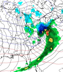
Last night’s models showed significant agreement that a classic coastal snow storm (“Miller type B”) will develop Tuesday night into Wednesday and intensify as it moves up the coast. Current QPF values are very high- as much as 1.80 to 2.00 inches water. This has the potential of translating into 14-20 inches of snow assuming a ratio of 1:10.
Current track is a ‘sweet spot’ for snow development in PHL and westward. Highest amounts on either side of the I-95 corridor.

Right now, current thermal profiles support snow, not a mix.
I’ll update later this morning with the latest models.
