Update Sat @ 9:51 AM — Our neck of the woods has about 5 inches of snow, just below the low range of last night’s NBM forecast for here (5.9″)
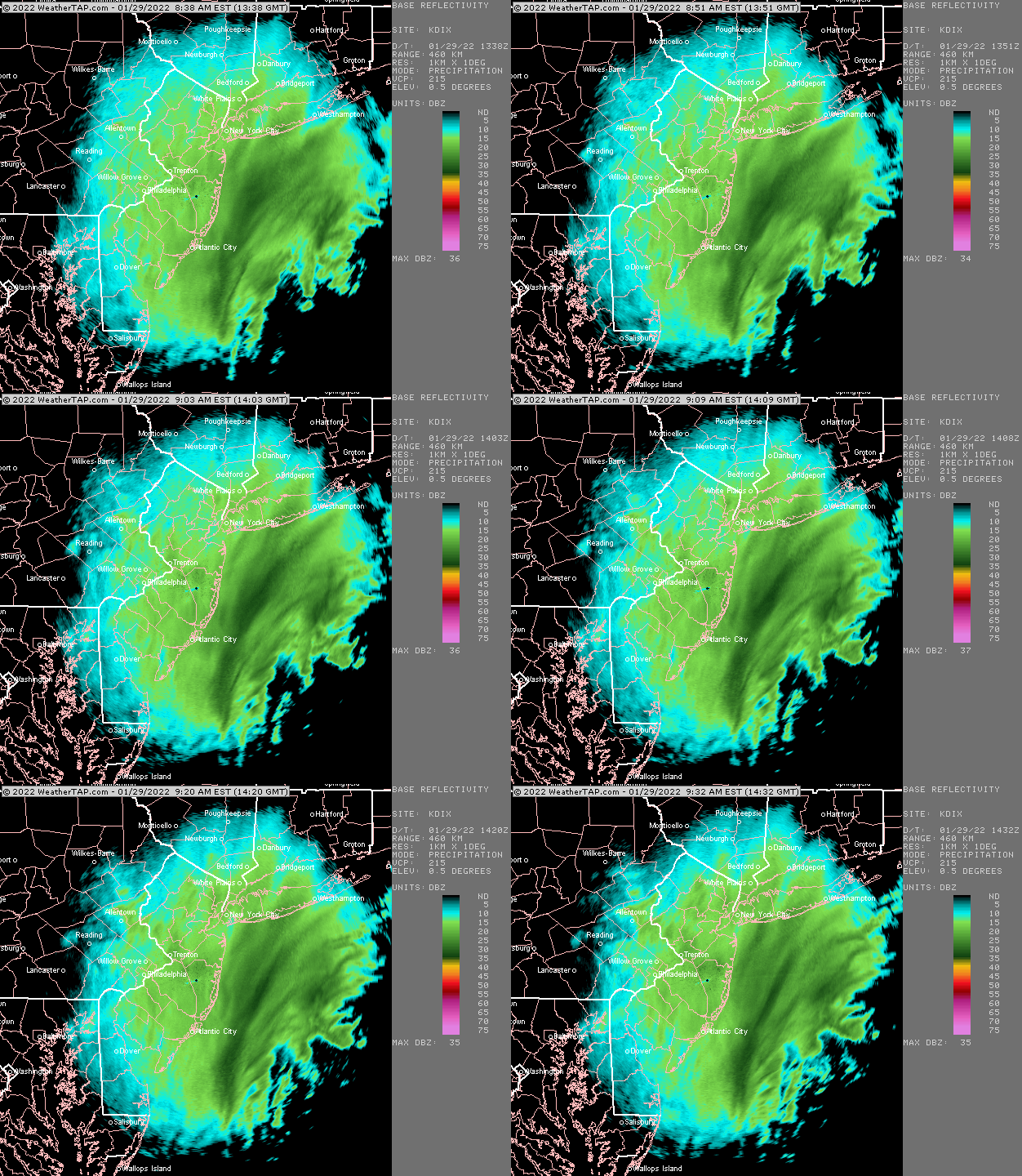
Additional snow until noon is expected. Here’s the current radar loop—
Nexrad Radar 9:32 AM loop, courtesy of https://.weathertap.com (Click on image for a larger view.)
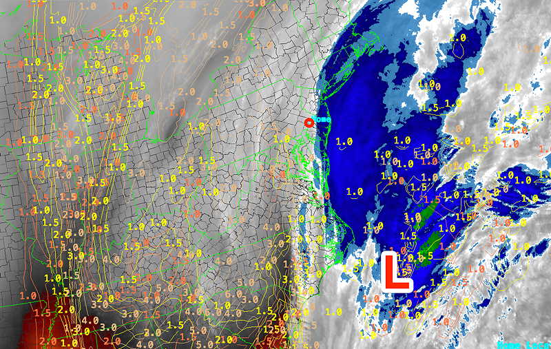
Of interest is the water vapor image which shows a possible low pressure center developing near the coast of NJ in response to the upper low passing through.
Upper air low center developing some circulation off the southern coast of NJ at 9:30 AM (Click on image for a larger view.)
This will likely provide some late enhancement of snow towards its final taper.
Update Fri @ 10:54 PM — Tonight’s GFS just came out. Consistent with the range of the NBM model just posted, a little higher accumulation in western sections.
Update Fri @ 10:13 PM — Tonight’s models are fairly consistent with the afternoon runs. Several models have moved a bit lower with snow totals (specifically the NAM, Canadian GEM and ICON) and some have moved higher (RAP, HRRR)
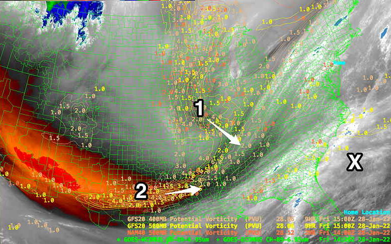
The current developing storm is fairly consist with the models, based on the latest water vapor imagery—
WV image with superimposed potential vorticity. (Click on image for a larger view.)
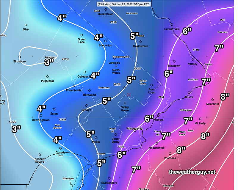
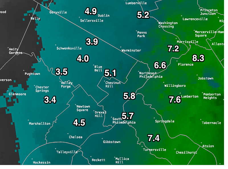
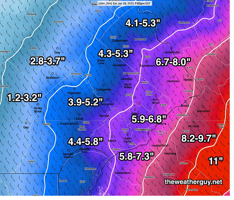
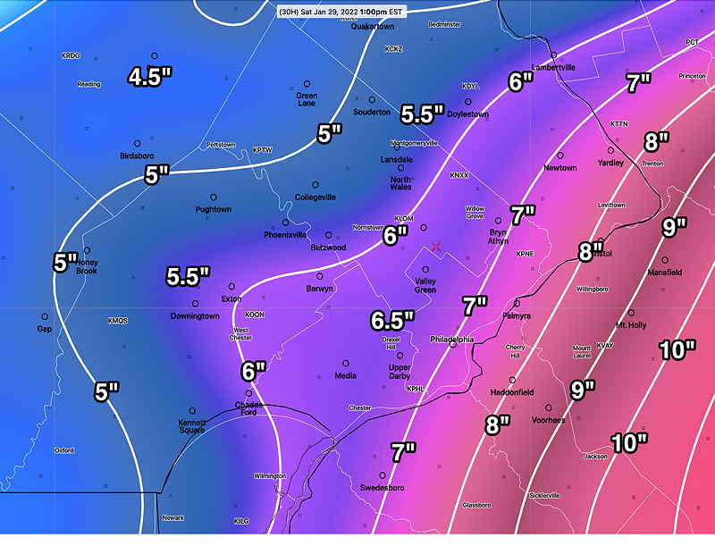
Again, I’m going to lean on the NBM model (model blend) which is designed to do all the hard work of coming up with a composite snow total.
NBM 00z percentile range snow totals for this storm. I’m leaning towards the lower number, especially from Philadelphia westward. (Click on image for a larger view.)
My present inclination, based on the NAM trend, is to lean towards the lower range number in the NBM from Philadelphia and westward.
Update Fri @ 5:25 PM — Today’s snowfall was more widespread and lasted longer than previously forecast. Does that bode well for the rest of the forecast?
The afternoon models have become available. Both the GFS and NAM are in a similar range as this morning, but with a trend downward of about 0.5″-1′ overall in Philadelphia and surrounding areas. That can simply be model variation. Snow totals are posted below.
I did notice that the water vapor image and the GFS/NAM model vorticity do not superimpose very well, suggesting some modeling error. I guess we’ll find out.
Water Vapor and forecast Potential Vorticity . Are the models too far west with their forecast? I guess we’ll see. (Click on image for a larger view.)
Snow starts this evening and lasts through the morning in the Philadelphia area. Ends by noon or so. Longer at the shore.
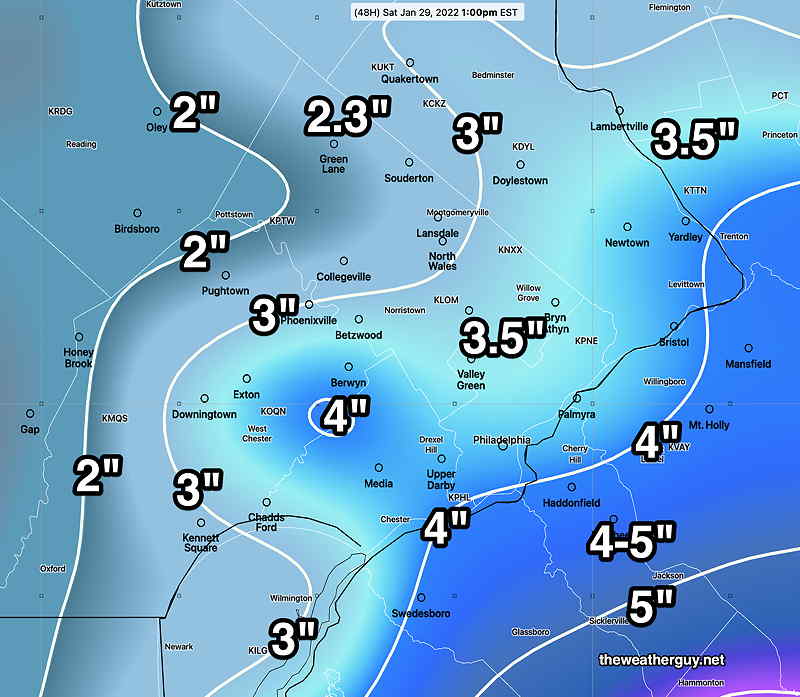
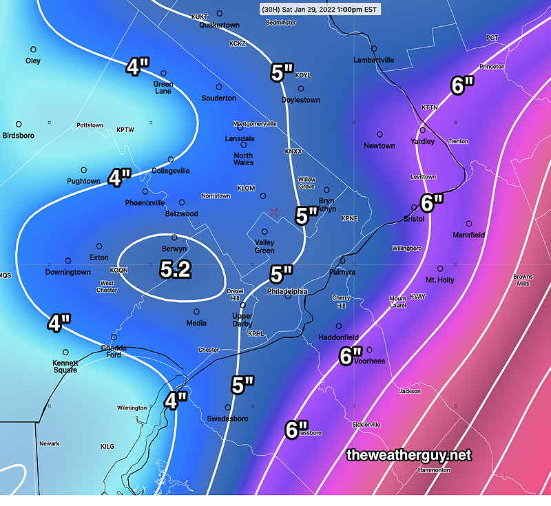
The model blend (NBM) is designed to do all the heavy lifting and here’s its current forecast—
NBM Model Thur 19z Average (mean) snow totals by 2 PM Saturday (Click on image for a larger view.)
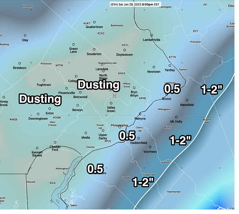
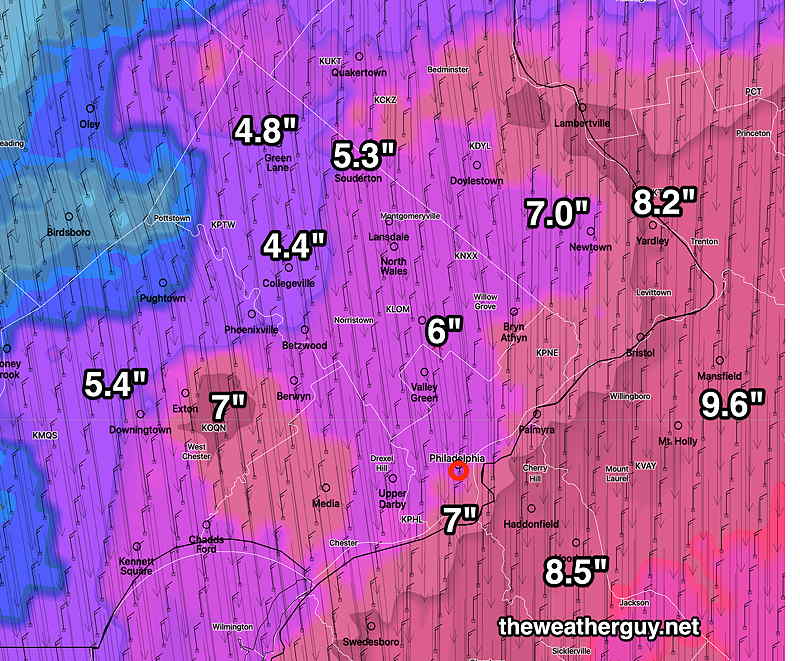
This afternoon’s high resolution HRRR has this forecast—
HRRR 18z snow totals by 1 PM Saturday (Click on image for a larger view.)
I’m probably going to stay with this forecast. This evening’s models run the risk of not necessarily being more accurate due to lack of adequate model spin-up time. But I will chime in if there are major changes.
Update Fri @ 11:02 AM — The latest GFS just became available. As is almost always the case, its totals are somewhat less than the NAM—
GFS 12z snow totals White contours are 1 inch increments. (Click on image for a larger view.)
I’m providing this morning’s NAM forecast again for easy comparison—
NAM 12z (Click on image for a larger view.)
My rule of thumb is to average the GFS and NAM for a best forecast.
Food for thought. The latest HIRESW-ARW 2.5 KM (high resolution)— (possibly too high?)
HIRESW-ARW 2.5KM high resolution. White contours are 1 inch increments. (Click on image for a larger view.)
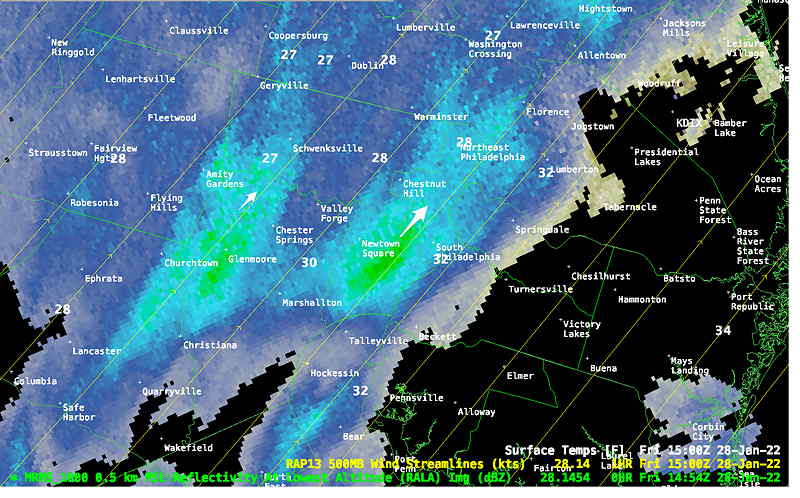
Update Fri @ 10:06 AM — FYI, the light snow this morning was predicted yesterday, although the amounts appear to be more than forecast.
MRMS RADAR 9:54 AM (Click on image for a larger view.)
The new 12z models are beginning to come in. (The 12z models, along with the 00z models, are important because they are the two daily model runs that include fresh directmeasurementupper air data from weather balloons launched globally.)
The trend is for an increase in snowfall with snow lingering into noontime Saturday in Philadelphia and later at the NJ shore.
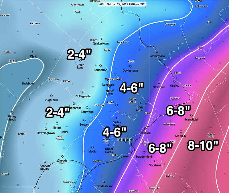
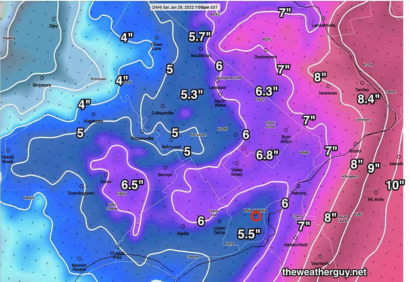
Latest NAM model just available—
NAM 12z snow totals 1 PM Saturday. (Click on image for a larger view.)
The model blend (NBM model) 12z —
NBM Model blend with median snow totals as white contours in 2″ increments. The ranges (in smaller type) show the 25th percentile and 74th percentile ranges for that area. The 75th percentile means that 75% of the models are at or below that amount. It’s tricky. (Click on image for a larger view.)
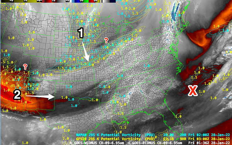
Things seem to be coming together, based on the latest Water Vapor image and superimposed NAM/GFS potential vorticity (see explanation below)—
Last night's (Thurs) Water Vapor with Potential Vorticity
Friday Morning Water Vapor showing Potential Vorticity
Update Thu @ 11:16 PM — Quick update. Latest GFS has increased snow totals almost as much as NAM.
GFS 00z Contours are 1″ increments (Click on image for a larger view.)NAM 00z Snow totals (Click on image for a larger view.)
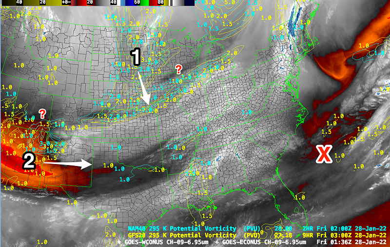
Update Thu @ 9:55 PM — One way of deciding if the models are on the right track is to see how their forecasts, in the short term, line up with actual observed conditions.
It turns out that a specific model derived parameter, “potential vorticity” corresponds very well with with warmer (darker) areas on satellite water vapor images.
Here’s tonight’s recent water vapor image with superimposed potential vorticity from this afternoon’s NAM and GFS forecasts. It looks pretty good, but there are some areas that are a bit off, designated as “?” below—
Major areas of potential vorticity (1) and (2) will combine and develop deep low pressure in area (X). There are a few areas, designated as (?), which are not perfectly forecast by this afternoon’s NAM/GFS models. That’s why forecasts need to change; models can’t exactly capture the future state of the atmosphere, but they can come close. (Click on image for a larger view.)
Tonight’s models are becoming available. The general trend has been an increase in snow totals.
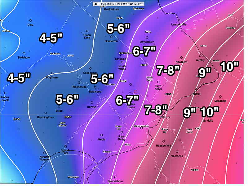
Here’s the latest NAM forecast Saturday 3 PM—
NAM 00z Snow forecast depth (Click on image for a larger view.)
I think the NAM might be a tad too high. (Tonight’s NAM-NEST is an inch or two below these amounts.) Ultimately I think we’re going to go with an average of the GFS and NAM.
The GFS is out about 11:05 PM. I may not be able to update until tomorrow morning.
Previously Posted Thu 5:32 PM —
The storm late Friday through Saturday time frame has entered into the range of the high resolution models.
Our weather Friday through Saturday will be influenced by a sharp upper air trough and a deep storm developing in the western Atlantic.
Everyone knows that there has been much uncertainty regarding the track and snow potential here around Philadelphia. The models have been back and forth regarding position of the storm and the size of the precipitation shield westward.
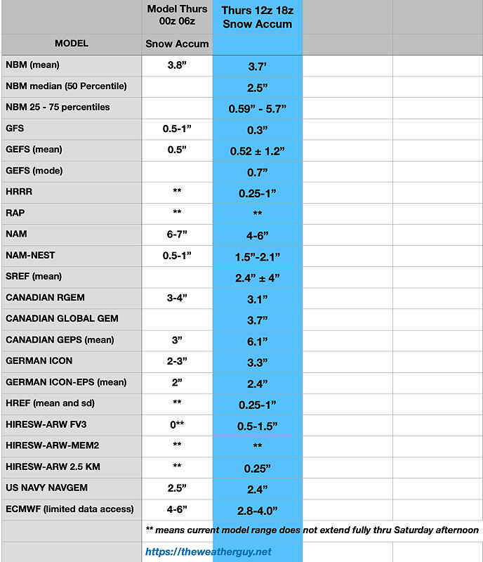
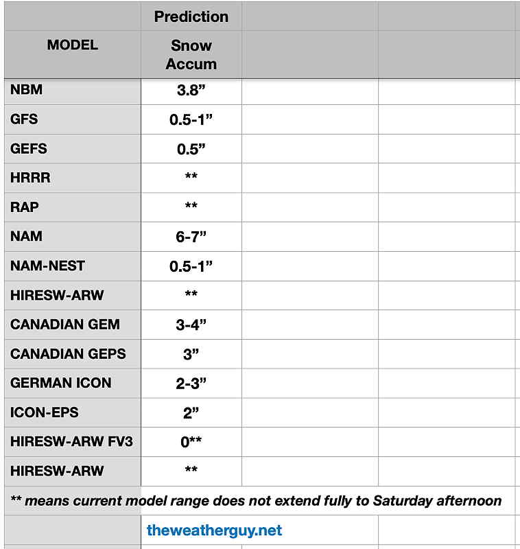
Here’s a summary (you’ll only find this here!)
Most recent snow forecast in blue column. THIS IS FOR A SINGLE LOCATION- BLUE BELL PA. YOUR MILEAGE MAY VARY. (Click on image for a larger view.)
Regular readers know my motto, “Never Ignore the NAM”. And it’s time not to ignore it.
Here’s the latest NAM Model forecast–
NAM 18z snow forecast (Click on image for a larger view.)
Here’s the latest GFS which has just joined the rest of the models with significant snow here—
GFS 18z forecast for 1 PM Saturday (Click on image for a larger view.)
I am going with an average of the NAM and GFS models at this timeas the most likely snow totals.
With the high resolution models coming into the mix, here’s the forecast:
Friday:
An upper air disturbance and cold front will move through. We’ll have light snow break out northwest of the city as early as late morning Friday. Light snow/flurries on and off, mostly north and west of the city. Accumulation a dusting to 1/2 inch. High 34º sd 1.7º NBM model Blue Bell.
Snow starts Friday evening.
Most of our snow with this storm will occur Friday night into early Saturday morning.
Saturday:
Cloudy, cold and WINDY. Snow tapering and ending in the morning but lingering at the NJ shore. High 23.2 sd 2.9º NBM model Blue Bell
Update Thu @ 11:13 AM — The new GFS model’s snow forecast just became available—
GFS 12z forecast Snow totals by 8 PM Saturday. (Click on image for a larger view.)
I’ll try to make sense of these giant differences later this afternoon. Right now I’m inclined to go with the GFS, but that could change.
Update Thu @ 10:17 AM — This morning’s early models are becoming available and their higher resolution forecast ranges are taking us to 1 PM or 7PM Saturday timeframe.
The dichotomy between the NAM and GFS still exists. Here’s the very latest NAM snow forecast—
NAM 12z snow forecast through Saturday 7PM (Click on image for a larger view.)
Despite the new NAM forecast,the other new models entering into the picture this morning are tending towards the much lower snow totals of the GFS.(about 1 inch in Philadelphia and less west)
The new GFS comes out just after 11 AM. I’ll take a look and update. Stay tuned.
Update Thu @ 8:43 AM — A quick update with last night’s 00z and 06z model trends. The GFS remains as the eastern outlier with the NAM back with a significant snowfall. European ECMWF still shows 4-6″.
Here’s current snow totals by model (for grid point: Blue Bell PA)
Current model snow forecasts by model for Blue Bell PA. (areas east will have more; this is only one point data)





 Last night's (Thurs) Water Vapor with Potential Vorticity