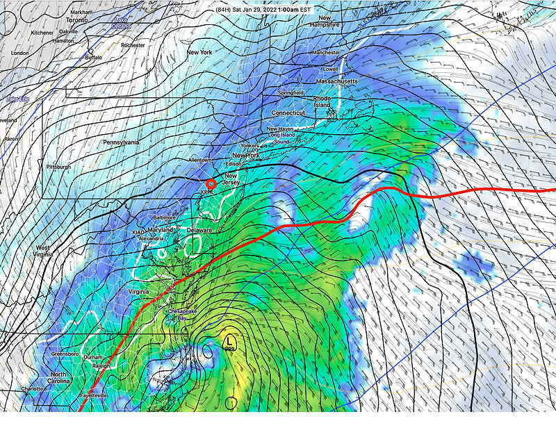
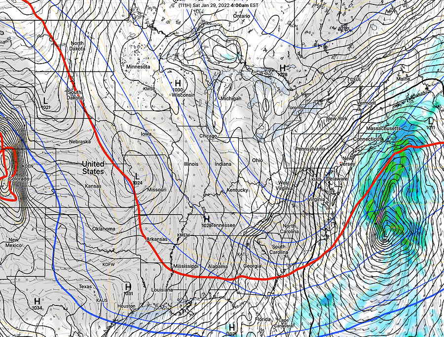
Update Thu @ 11:13 AM — The new GFS model’s snow forecast just became available—
GFS 12z forecast Snow totals by 8 PM Saturday. (Click on image for a larger view.)
I’ll try to make sense of these giant differences later this afternoon. Right now I’m inclined to go with the GFS, but that could change.
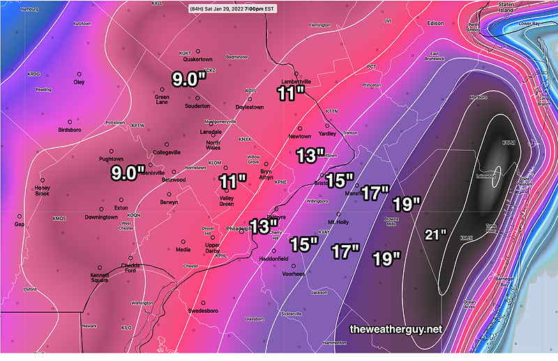
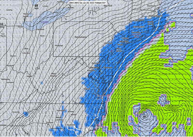
Update Thu @ 10:17 AM — This morning’s early models are becoming available and their higher resolution forecast ranges are taking us to 1 PM or 7PM Saturday timeframe.
The dichotomy between the NAM and GFS still exists. Here’s the very latest NAM snow forecast—
NAM 12z snow forecast through Saturday 7PM (Click on image for a larger view.)
Despite the new NAM forecast, the other new models entering into the picture this morning are tending towards the much lower snow totals of the GFS.(about 1 inch in Philadelphia and less west)
The new GFS comes out just after 11 AM. I’ll take a look and update. Stay tuned.
Update Thu @ 8:43 AM — A quick update with last night’s 00z and 06z model trends. The GFS remains as the eastern outlier with the NAM back with a significant snowfall. European ECMWF still shows 4-6″.
Here’s current snow totals by model (for grid point: Blue Bell PA)
Current model snow forecasts by model for Blue Bell PA. (areas east will have more; this is only one point data)
More updates later… stay tuned.
Update Wed @ 11:11 PM — A quick look at tonight’s GFS just available shows virtually no snow in Philadelphia from this storm . Only eastern NJ. Stay tuned.
Update Wed @ 9:47 PM — This afternoon’s Canadian RGEM and German ICON are very similar to the earlier GFS with low snow accumulations in the immediate PHL area and westward.
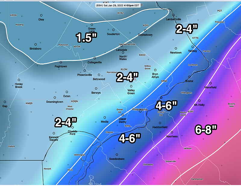
However, just when I thought I could put this storm to bed, tonight’s models have started to become available. The NAM has reverted back to somewhat higher snow totals—
NAM snow totals for Saturday 4 PM (Click on image for a larger view.)
Tonight’s model blend (NBM) maintains a wide range of snow totals, reflecting remaining uncertainty.
Tonight’s NBM (00z)— Be certain to look at the wide percentile ranges in smaller font
NBM Median (50 percentile) snow forecast, with 25 percentile and 75 percentile in smaller type (Click on image for a larger view.)
The latest GEFS (18z) shows increased uncertainty of position after 10 AM Saturday in the storm’s western quadrant—
GEFS forecast at 1 PM Saturday shows increased uncertainty (high standard deviation) in northwestern quadrant; likely too late to affect our weather. (Click on image for a larger view.)
Not clear whether the uncertainty translates into higher snow totals.
The NAM-Nest forecast isn’t much use yet since it only forecasts up to 60 hours.
The new GFS becomes available about 11:05. I’ll update if I’m not asleep! 🙂
Update Wed @ 5:13 PM — Wow, this storm at least for Philadelphia, has fizzled out. The latest GFS just available continues with the trend of the storm moving away from us.
GFS forecast for Noon on Saturday. Precipitation barely makes it into Philadelphia. (Click on image for a larger view.)
GFS snow totals—
This afternoon’s 18z GFS just available Snow accumulation by Saturday afternoon (Click on image for a larger view.)
Update Wed @ 3:54 PM — A quick update. Today’s GFS, GEFS and Canadian GEM are all pointing to an eastern storm track, much lower snow accumulations. The SREF just available has backed away from extreme totals of the NAM as well.
Incredibly (and not atypical for the NAM) the 18z NAM just became available and it has the storm virtually missing us! Those wild swings in the NAM are the reason “Never ignore the NAM” does not apply for its longer range forecasts. Seen it before!
Latest GEFS snow totals with standard deviation (sd)—
GEFS forecast, mean with standard deviation. For those rusty about statistics, a standard deviation is a quantification of spread (uncertainty) in a group; in a normal distribution, approx 67% of the models fall within 1 standard deviation of the mean. (Click on image for a larger view.)
I’ll have new graphics a bit later this afternoon, but the GFS forecast just below is looking about right for now.
Update Wed @ 11:14 AM — I wasn’t going to update until later, but I took a peek at the new GFS that just came out and it still has a minimal storm for us! ( A fraction of the snowfall of the NAM forecast).
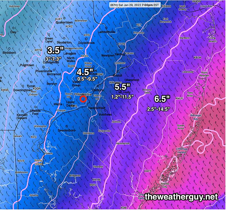
GFS snowfall (latest)—
GFS Snowfall totals by 7 PM Saturday (Click on image for a larger view.)
I’ll try to make sense of this later this afternoon. Stay tuned.
Update Wed @ 10:04 AM — The new morning models are coming in and despite the shift of the GFS eastward last night, it’s almost close enough to invoke the mantra, “Never ignore the NAM”
The storm is now within forecast range of the NAM model. The NAM continues with its more coastal (westward) storm with severe intensification Saturday morning. The NAM has moved into the range of the European ECMWF
Today’s 12z NAM show intense deepening of this storm (976 millibar central pressure) and large precip shield with a more westward track. (Click on image for a larger view.)
Here are the latest NAM snow totals. Too early to hang one’s hat on this forecast, but I think it’s helpful to know the range currently being forecast—
This morning’s NAM snow forecast by Saturday 7 PM (The white contours are every 2 inches.) (Click on image for a larger view.)
Stay tuned for more updates, likely later this afternoon.
Update Wed @ 8:02 AM — A quick update:
Note that this morning’s GEFS models are tracking a bit more eastward, resulting in a rapid decrease in snow totals from Philadelphia westward.
Here’s the latest NBM percentile snow totals by Saturday afternoon. Note the tremendous range between the 25th percentile and the 75th percentile.
The 50th percentile is the larger number. (Percentiles are tricky concepts….the 50th percentile indicates that half of the models have this snowfall amount or less;half of the models have more. It’s NOT the model average, nor is it necessarily the most likely amount.)
NBM model snowfall percentiles. 25, 50 and 75th percentile. The 50th percentile, also referred to as the median, is the larger number. (Click on image for a larger view.)
Update Tue @ 9:56 PM — This storm will come into the range of more models tomorrow. For tonight, we have a new GEFS and a new SREF which provide some new insights about the uncertainty in the forecast path and speed of the storm. Both model ensembles have the mean position of the low pressure system in similar positions, and similar to other models, although the SREF is a bit more east.
Both suggest the most uncertainty (standard deviation) is northeast of the center, suggesting that the storm may move faster than shown and/or the storm will be deeper than shown at 7 AM.
The GEFS also suggests slightly greater uncertainty (?) west of the center, suggesting that the storm may be slightly closer to the coast.
I still don’t yet see much support for the European ECMWF model, which is predicting a major snowstorm for us.
I should mention that the latest ICON model has shown a track consistently eastward with little snow for us.
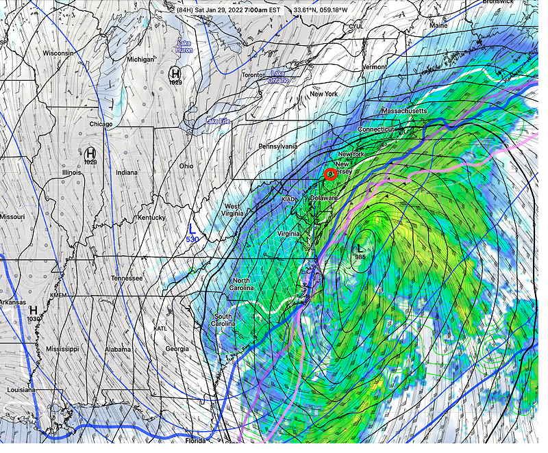
Also just available is tonight’s NAM which forecasts out to 84 hours. The NAM currently is fairly close to the coast at 7 AM and is forecasting about 2-3 inches by that time. While my regular readers know my mantra, “Never ignore the NAM”, that applies just 24 hours before an event. This far out, the NAM storm tracks are unreliable.
NAM forecast Saturday 7 AM (Click on image for a larger view.)
Update Tue @ 5:25 PM — With this afternoon’s models, there’s been some interesting trends. The GFS has trended a bit closer to the coast compared to the GEFS as well as its position forecast from this morning. That said, it keeps most of the snow in NJ, with a fast taper to an inch or so in Philadelphia.
I did get a chance to look at limited data from the European ECMWF, which currently forecasts a deeper storm than the GFS, closer to the coast. It has a significant snowstorm for New Jersey into the Philadelphia area. I’m not ready to get on the ECMWF band wagon.
This storm will be huge and intense. It seems that despite its eastward track, the precipitation shield may be large enough to still throw back snow over our region. At this point, any accumulation forecast would be just a guess. But it’s fair to say that New Jersey will likely see more than Philadelphia and accumulations will decrease from east to west.
The meso-scale models that extend their forecasts out 84 hours (NAM, Canadian RGEM) are finally coming within forecast range of this upcoming weekend’s storm.
The latest NAM is interesting in that it has a decidedly closer, more westward position of the storm at 84 hours (1 AM Saturday, its current forecast limit ) —
Today’s 18z NAM model forecast for Saturday 1 AM. The position of the main low center is much closer to the coast with snow extending into our area. (Click on image for a larger view.)
(This afternoon’s Canadian RGEM just available, has the storm moving much faster and eastward. Right now, it’s in its own camp, but it leans towards little snow in Philadelphia.)
The tonight’s run of the NAM will become available about 9:45PM. I’ll update after that time. Stay tuned.
Update Tue @ 12:49 PM — For the snow lovers out there not willing to give up on hope, the latest Canadian Global model still shows about 2-3 inches of snow for us on Saturday —
Canadian Global 12z forecast for Saturday 7 PM showing precipitation type and 32º line (Click on image for a larger view.)
So the track of the Canadian model is not necessarily closer, but it shows a wider precipitation shield than the GFS (below).
By the way, I took a look at the GFS snow totals and it does show about 1-2 inches in Philadelphia, despite the eastward track.
Update Tue @ 12:02 PM —This morning’s new GFS ( 12z )just became available. Very consistent with its previous statistical counterpart, the GEFS. The GFS still shows its snow shield barely making it into Philadelphia. (see snow total update above) Things can still change, and I hate to disappoint the snow lovers out there, but there has been too much model consistency to believe at this time that it will come closer to us.
This morning’s latest GFS forecast little change in track, essentially missing us. (Click on image for a larger view.)
This morning’s ICON-EPS (ensemble) model just became available. It no longer shows uncertainty towards us and the east coast. Instead, uncertainty is in speed and direction northeastward—
ICON-EPS (ensemble) 12z forecast for Saturday 7 AM showing pressure and pressure standard deviation (shading) Uncertainty is no longer towards us. (Click on image for a larger view.)
We’re at the 96 hour forecast point, still only in the range of the global models. We have to wait for the forecast point to get to 60-84 hours for other models to make their forecasts. Other global models and ensembles will be available this afternoon.
Update Tue @ 9:01 AM — Last night’s model runs (00z and 06z) of the global models moved the coastal storm decidedly eastward, away from us. That said, there’s still highest uncertainty (standard deviation) in our direction.
Graphics below show consistent eastern track, with snow shield just brushing our area. Uncertainty graphic (darker colors) show similarity with greatest uncertainty westward and northeastward—
Canadian GEPS uncertainty (darker color) 7 AM Saturday
So this storm was never shown to hug the coast and current forecast track is consistent between models and with previous runs. Still, there is uncertainty as shown by high standard deviations to the east and northeast. Some snow still possible, as we get the northwestern fringe with current track. Stay tuned.
Update Mon @ 8:18 PM — Comparing today’s 18z GFS, GEFS, Canadian GEPS, and ICON model’s s forecast at 7AM Saturday—
GFS 18z Forecast 7 AM Saturday
GEFS (ensemble) 7 AM Saturday
ICON 18z Forecast for 7 AM Saturday
Canadian 12z GEPS Forecast 7 AM Saturday
The above graphic shows that the latest version (18z) of the GFS is forecast to be further away from us than either the 18z statistical version (GEFS) or the the latest ICON. The Canadian 12z GEPS (not run at 18z) is very different with speed and position. Click on the above graphic to animate.
Update Mon @ 5:24 PM — I was just about to consider a separate web page for this possible upcoming weekend storm. But the very latest GFS 18z just became available and it has the storm taking an eastern track, mostly missing us.
GFS 18z showing eastern track of storm with precipitation missing us. (Click on image for a larger view.)
In this time frame, the statistical ensemble models are generally used, to try to minimize the “model of the hour” or “model of the day” effect. But it is interesting that there’s been this shift eastward again. Stay tuned.
Update Mon @ 11:45 AM —Here’s the latest on the potential Nor’easter for the Philadelphia area late Friday into Saturday.
While previously looking like it would miss us, the latest trend is for the storm to be closer to the coast. The GFS as well as the GEFS mean and GEFS mode have all trended westward. The potential for several inches of snow by Saturday morning is there. The Canadian models have different speeds but somewhat similar westward trends.
Here’s the very latest GFS forecast for 7 AM Saturday—
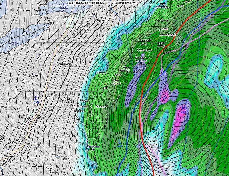
GFS forecast 7 AM Saturday showing precipitation rates. Anything west and north of the red 540 thickness line would be snow. The other thickness lines along the coast suggest NJ would have sleet and freezing rain. An evolving situation with much time for things to change. (Click on image for a larger view.)
This is an evolving situation with plenty of time for things to change in a multitude of ways before Friday. Stay tuned.
Previously Posted Sun 9:07 PM —
January Thaw? The almostannual warm up usually occurring the third to fourth week in January is nowhere in sight. It looks like we’re going to have to wait (until at least February) to get our annual thaw.
A cold, wide upper air trough will remain with us for this week, with a slight warm up on Tuesday before another cold front moves temperatures at or below seasonal averages.
This is what the models are showing for this week.
A relatively quiet seasonably cold flow will change to a highly amplified flow by Friday. Energy in the northern jet is expected to dive south Friday and phase with the southern jet stream, creating an intense coastal storm. Multiple models are forecasting this storm and multiple models have the storm somewhat missing us.
Previously Posted Sun 9:07 PM —
GEFS statistical mode forecast with bias-corrected precipitation—
Wide cold trough over us on Wednesday through Thursday
Jet stream dives south on Friday
Coastal storm develops east late Friday into Saturday
Right now, we would be on the very western fringe of the precipitation (snow), with the main storm missing us. As is always the case with a forecast 5 days ahead, things are likely to change. Stay tuned.


 GEFS forecast for Saturday 7 AM


 Wide cold trough over us on Wednesday through Thursday
