
#weather #paweather #wx #pawx #philadelphia #phillywx
Sunday Forecast Update — Monday Outlook
Update Sun 06/11 @ 9:01 AM — Today, we’ll finally see some summer-like weather. High temperatures 89º (Blue Bell) to 91º (Philadelphia). Some areas will experience some cloudiness at times during the afternoon today, but “partly to mostly sunny” is the standard terminology.
Dew points, according the the NBM, will be in the upper 50s instead of the upper 60s (as forecast yesterday), so it won’t be as humid as previously predicted.
Monday looks to be “interesting”, as a cold front moves through with much needed rain. Things are looking better for a good soaking in many (but not all) areas. The Canadian models are treating this as a warm front in the morning, followed by a cold front in the evening.
As a result, the RGEM and HRDPS have been predicting some shower activity as early as the late morning, followed by thunder showers from the afternoon through 9 PM.
Our NOAA models are underplaying the warm front and emphasizing the strong cold front, with showers and thunderstorms, from mid afternoon into the evening.
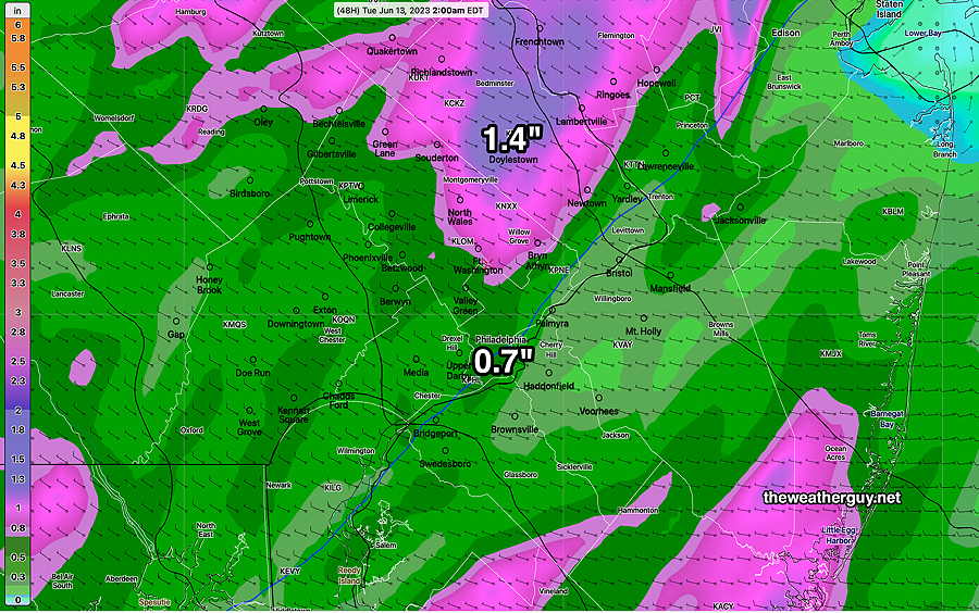
Precipitable water (PWAT) is in the 1.7″ to 2″ range, so some areas may get rainfall in that upper range. Generally 0.6″ to 2+ inches of rain is expected.
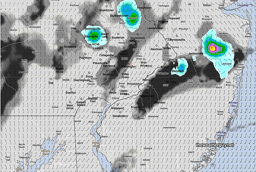
No tornadic activity is expected, and while strong storms are possible, many of the severity parameters are in the moderate range.
(I’m sure there will be official “severe thunderstorm warnings”, since there are liability issues in not issuing these. If you or your house gets hit by lightning, I guess it’s ‘severe’. )
Severity parameter forecasts have a strange way of dramatically increasing the day of the event, so I’ll be keeping an eye on this.
Saturday-Sunday Forecast Update
Update Sat 06/10 @ 9:28 AM — There’s some uncertainty with the amount of cloud cover for Sunday afternoon. Last night’s models showed only high level cirrus cloudiness, but several models are suggesting some periods of some mid and low level clouds (with sunny breaks) by mid afternoon.
The Canadian HRDPS is also showing the possibility of widely scattered showers/thundershowers far north of the city by 3-4 PM
Previously Posted Fri 5:30 PM —
Following the passage of an upper air trough through our area Friday evening, high pressure in the western Atlantic will circulate warmer air into our area over the weekend—
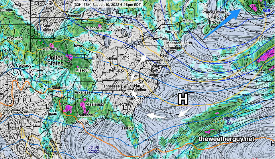
As mentioned last week in several posts, there appears to be a breakdown happening in the long-standing Omega block (Ω) that has been responsible for our cooler and dry weather for the past 5 weeks.
The new pattern, expected by the end next week, will likely be much warmer for us, but it’s unclear that it will become much wetter as well.
Indeed, Monday’s cold front that should bring some significant showers and thunderstorms to areas west of us, but may not bring all that much rain to Philadelphia and New Jersey. We’ll have to see.
Saturday
Mostly sunny.
High temperature 80.4 sd 2.0º ( NBM model— location Blue Bell, PA)
Sunday
Mostly sunny in the morning, gradually increasing cloudiness in the afternoon as some moisture from the system in the Midwest moves in aloft.
High temperature 88.0º sd 1.5º ( NBM model— location Blue Bell, PA)
Rain tomorrow will be welcome.
Is there any indication that the frontal passage tomorrow will usher in a pattern change with the possibility of more regular rain? Or so far is tomorrow more of a “blip” and dry weather will likely return?
That’s a great question and honestly, I’m not sure. I’m thinking that it will be hotter but not necessarily much wetter. (Then again, it wouldn’t take much to become ‘wetter’.) Looking at the extended GEFS, it looks like the general pattern moves to a typical summer-time ridge in the central US. Much hotter for us than it’s been over the past 5-6 weeks. In this pattern, disturbances can move over the ridge and thunderstorms are more likely than the opportunities we’ve had.
A Bermuda high sets up which can rotate moisture from the south and southwest, again more summer-like. I’m definitely concerned that any thunderstorms may run into that high pressure “wall” where they dissipate, just like last summer.
Despite the rain tomorrow, the actual change in pattern doesn’t really start until the middle to end of this week. In the short term, after we get the rain tomorrow, things look dry through next Sunday. The rain with the front tomorrow will be associated with an upper low that hangs out again in northeastern Canada, not to dissimilar to what we’ve had over the past several weeks. But the true Omega block looks like it’s flattening out.