SNOW ON SUNDAY

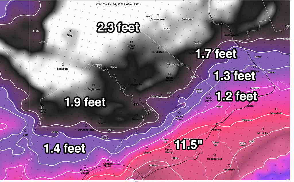
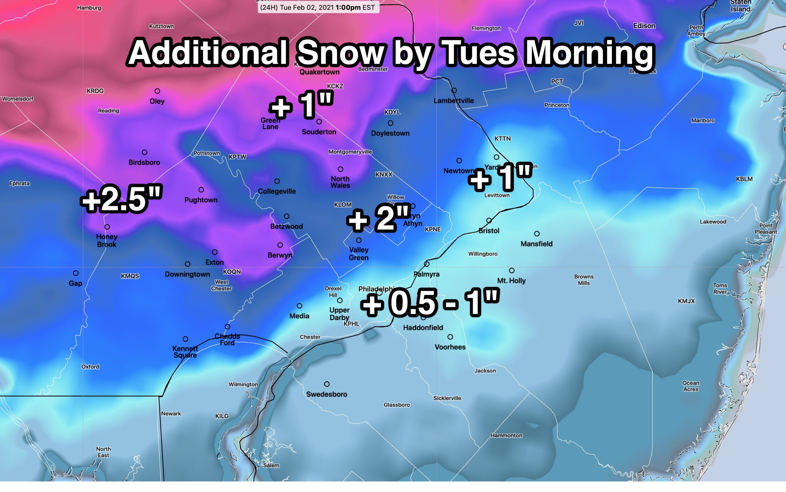
Forecast Updated Sun 8:00 AM— Last night’s model blend  has continued to reduce final snow totals by about 1 inch less those posted below.  Dynamic cooling has only reduced surface temps to above or about 32º which may limit full accumulation on roadways.  

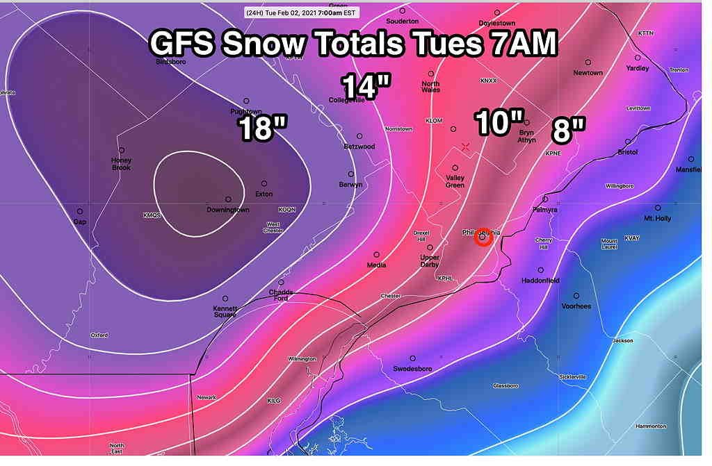
8:11 AM. It should be noted that the NAM continues to predict almost 6 inches.

New models by about 9:15 AM


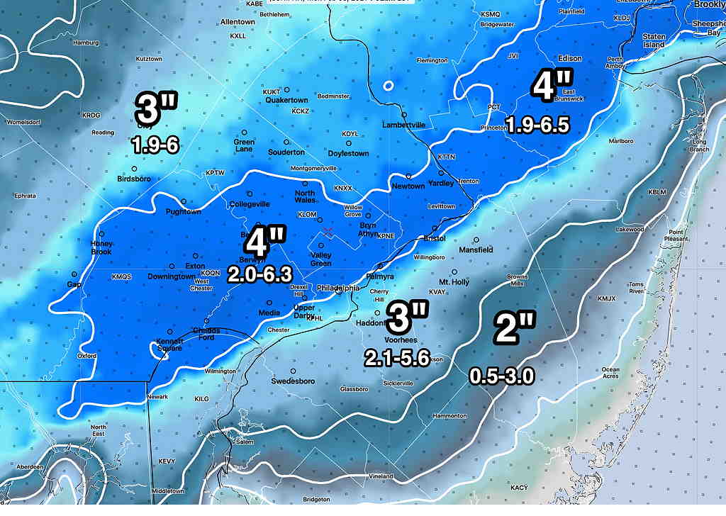
Forecast Updated Sat 9:11 PM — Tonight’s NBM, HRRR, RAP and NAM models have become available.  The model blend (NBM) continues with the trend of slightly lower snow totals, although the spread of possibilities remains somewhat large—

NBM 00z snow totals (50 percentile) with 25 and 75 percentiles in smaller text.  Spread remains large. (Click on image for a larger view.) 


The NBM 3 inch snow totals are in line with the RAP (4 inches) and ICON (3.5 inches), HRRR 2.5 inches. 

The latest NAM, just available, is highest and still shows 6 inches, which accounts for the high spread in the percentiles.  

I’m inclined to go with the NBM model numbers and probably 3-4 inches is a good forecast at this point for most of the area.


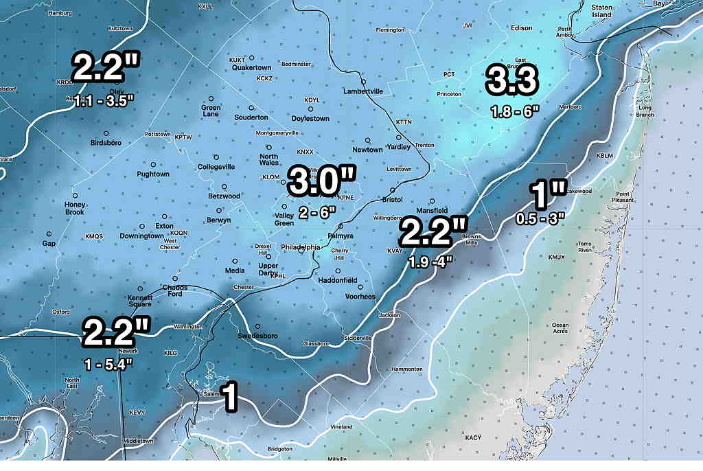
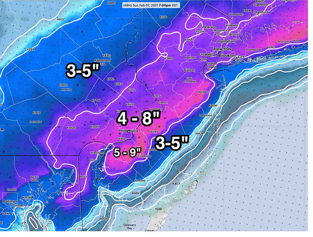
Forecast Updated Sat 6:10 PM — The 4PM Model Blend has reduced the 50 percentile snow totals by about 1/2 inch.  See graphic below.


Forecast Updated Sat 5:18 PM — This afternoon’s 1PM, (18z) models are in.

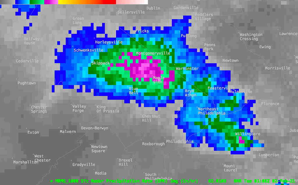
The models are in good agreement that the predominant precipitation type will be snow in the immediate Philadelphia area, starting  between 5 and 7 AM and ending around 2-4 PM.

QPF values are stable in the 0.4-0.55 inches water equivalent.   Current GFS water -snow ratio is in the 9.8 to 1 range. That is in good agreement with the current Model Blend  (NBM) percentiles. 

The NBM 50 percentile is shown below shaded with the 25 and 75 percentiles below it.  (Remember,  if you are were in the 90 percentile in your school test grade, it meant that your score was equal or greater than 90 percent of the other students.  It doesn’t mean that 90 percent of the other students got the same test score as you.)

NBM 50 percentile snow accumulation  (shading) with 25 and 75 percentiles shown in smaller type size.   (Click on image for a larger view.)


Food for thought is the ICON model which is remarkably similar to the NBM 50 percentile—

ICON 12z model snow totals.(Click on image for a larger view.)

It’s not expected to be windy during the storm. Winds pick up Sunday evening.


Forecast Updated Sat 9:01 AM — The trend is back to mostly snow for Philadelphia but less total QPF.

First some model info:

The major numerical weather prediction models are run every 12 hours,  or twice a day,  at 00z and 12z  (7 AM and 7PM EST).  Depending upon the model, it takes 1.5 to 6 hours to complete their calculations.  

Some of these major models have an additional run at “06z” and “18z”  (at 1 AM and 1 PM EST.)   (Not to complicate, there are hourly models too.)

Looking at the both of these major model runs from last night, the trend is for a lower QPF (total quantity of precipitation falling) than had been predicted Friday afternoon.  As an example, the NAM QPF for Philadelphia has reduce to almost 1/2 the amount from yesterday’s model run.

The models have clustered at a total QPF for our area between 0.3 and 0.6 inches of water or snow-water equivalence.  For areas that will be all-snow, that translates into 3-6 inches of snow based on a 1:10 ratio.

Here’s the latest ICON model from 06z which is at the high range

ICON model snow water equivalence.  (Click on image for a larger view.)


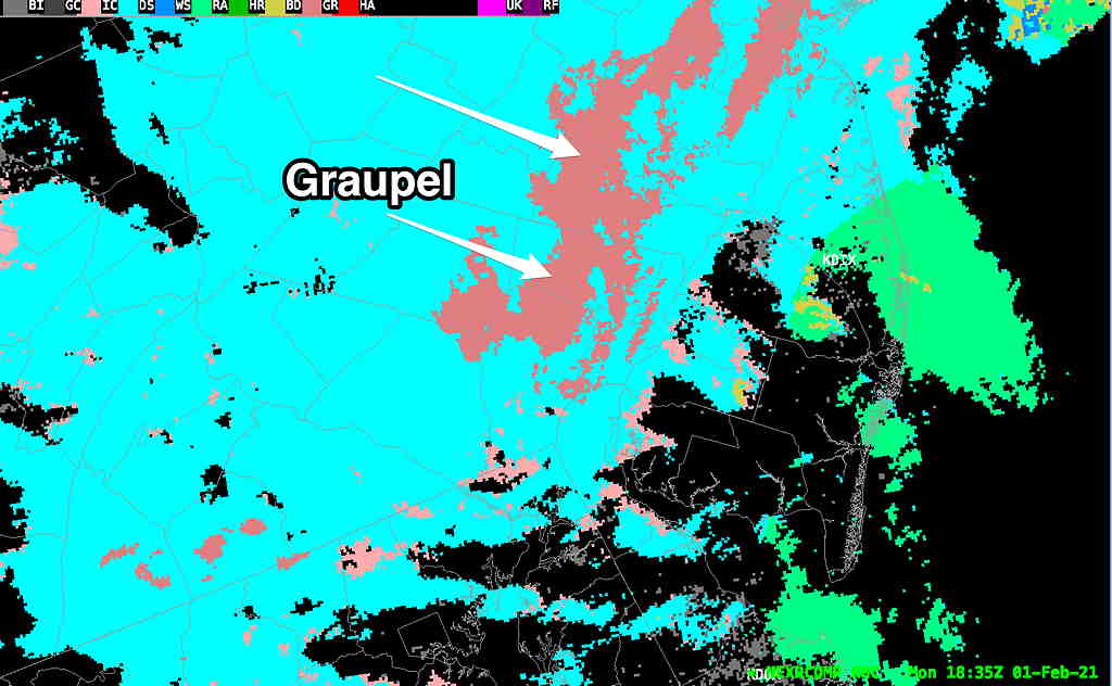
Here’s the SREF model showing precip type that I referenced last night.  Notice that it now has the snow-rain line south of Philadelphia, meaning more snow, less rain, for the immediate PHL area.   A significant change—

Latest SREF forecast model showing rain-snow line. Included are “critical thickness lines” The red line is 500-1000 critical thickness, a good quick rain vs snow determinant.  Also notice the white line, the surface freezing isotherm, is north of PHL, meaning snow may fall but it may be too warm to fully accumulate.  (Click on image for a larger view.)


Final forecasts of the rain snow line, surface temperatures and the amount of QPF will need to wait until this evening’s models come in.

Stay tuned.


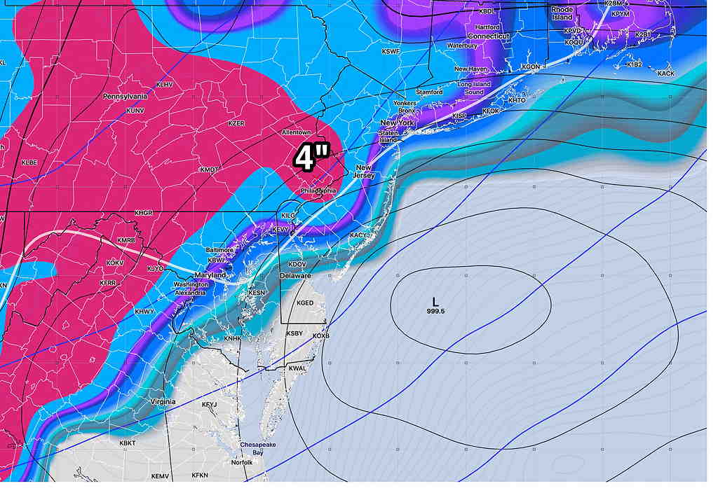
Forecast Updated Fri 9:27 PM —  A significant forecast complication has emerged.  Tonight’s models just becoming available show the low pressure system closer to the coast, bringing milder air in.   What was going to be all snow may now mix with sleet and rain, reducing snow totals significantly from what I had just posted below.   Here’s the latest SREF forecast showing the critical “thickness lines” (measures of average density of atmosphere layers correlated with temperatures)  are now north of Philadelphia by 1 PM

SREF forecast with critical thickness lines and snow/rain (Click on image for a larger view.)

If this trend continues, those high snow totals are going to wrong.

I used the latest NBM model (from 7PM-  00z ) for the snow totals below.  Unfortunately, the way the NBM model works, it takes at least 6 hours for the new models (with their warmer forecast)  to work their way into the NBM blend. 


Weekend Weather Forecast & Sunday Snow Update Fri 8:45 PM —

First, the regular Weekend Weather Forecast:  Saturday, mostly sunny.  Cloudiness moves in towards evening.  High 37º ± 2º (Blue Bell- NBM model).  Winds 10-15 mph with gusts to 30mph mid-day.

Sunday: Snow begins 4-6 AM as low pressure develops and moves just south of us.  Snow heavy in the morning, tapering off in the afternoon.   The trend has been for increasing snow totals and the trend for the heaviest snow right over Philadelphia and just east.  

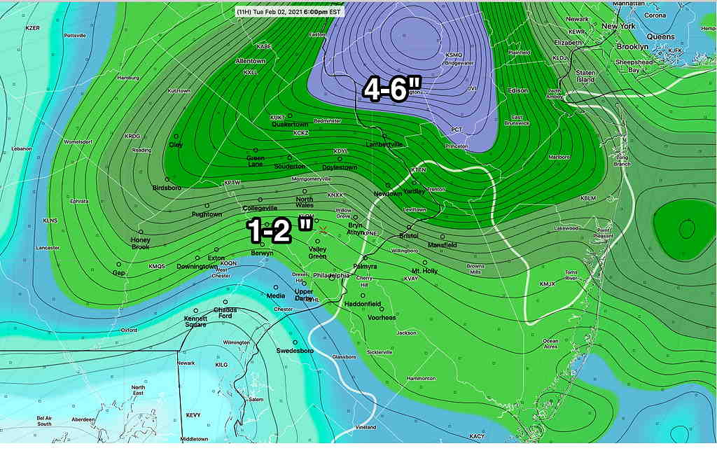
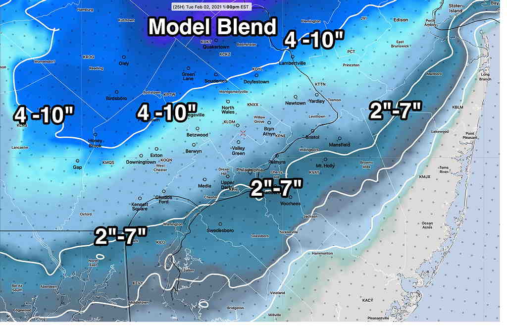
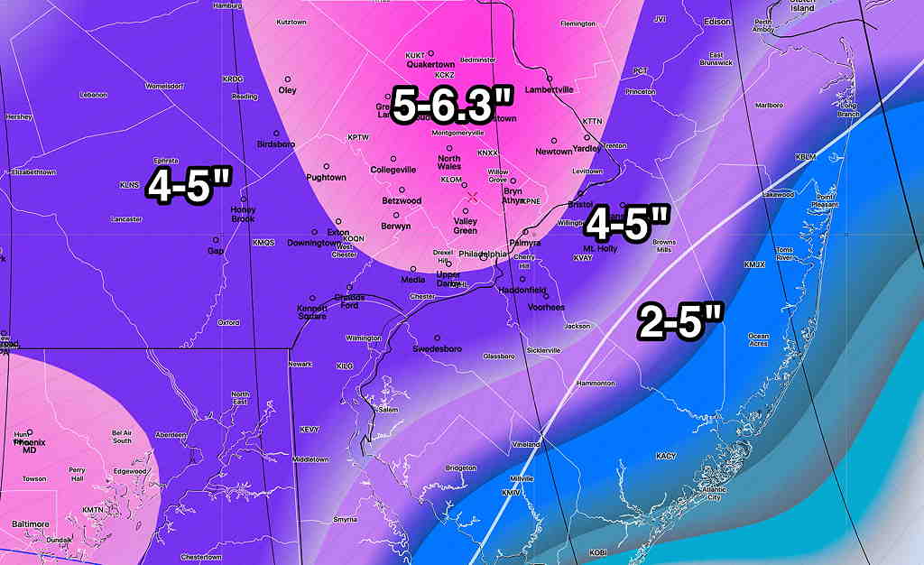
Using the model blend (NBM) 24 hour snow accumulation percentiles here’s where things look right now—

National Blend of Models (NBM) 24 hour snow accumulation 50-90 percentiles (Click on image for a larger view.)

The spread is large because I’m using the NBM 25/50 and 90 percentiles;  I’m including the 90 percentiles because this afternoon’s NAM was predicting in the high range. 

(A 25 percentile means that 25% of the models are predicting up to that amount;  a 50 percentile means that half of the models are predicting less than that amount and half are predicting more:  a 75 percentile means that 75% of the models are predicting less than that amount.    But it does NOT mean that 75% are predicting that amount.  You gotta wrap your head around it.)

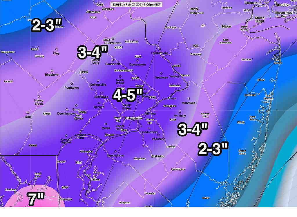
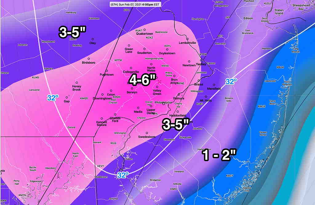
The latest ICON model from this afternoon has the following—

This afternoon’s ICON snow water equivalence converted to snow 1:10 ratio. 

Why am I using the ICON model??  It was one of the first this week to consistently show significant snow for us.  During our last storm, it was surprisingly good.

Stay tuned …


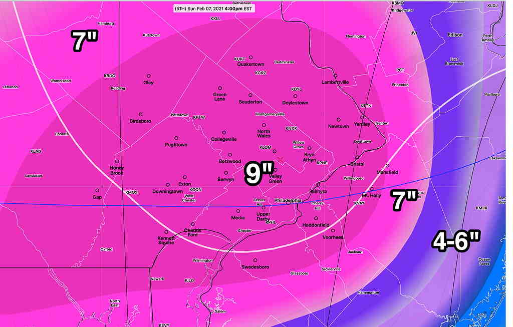
Forecast Updated Fri 5:51 PM — This afternoon’s models are pointing to a more significant snowfall for Sunday, starting before daybreak and ending in the afternoon.  Most of the immediate Philadelphia area will have all snow.  Using my old technique of snow-water equivalence,  4-10 inches of snow is possible in the immediate PHL area.  The  ICON model shows these snowfall totals—

ICON Model snow totals by Sunday afternoon  (Click on image for a larger view.)

The latest NAM model forecasts  2-4 inches greater than the above totals and the latest GFS is at the upper end of the range shown in the graphic.

This marks a major change in the forecast for this storm, that previously had been expected to pass by to our south,  missing us.

Stay tuned for an additional update with tonight’s models.

Additional Snow on Sunday?


Forecast Updated Fri 5:35 PM — This afternoon’s models are pointing to a more significant snowfall for Sunday, starting before daybreak and ending in the afternoon.  Most of the immediate Philadelphia area will be all snow.  Using my old technique of snow-water equivalence,  6-10 inches of snow is possible in the immediate PHL area.  The  ICON model shows these snowfall total—

ICON Model snow totals by Sunday afternoon  (Click on image for a larger view.)


The latest NAM model forecasts higher amounts by 2-3 inches from the above values and the GFS is on the upper end the range shown.


Forecast Updated Fri 11:51 AM — The latest GFS model has 2-4 inches of snow in the immediate Philadelphia area, starting Sunday  very early morning and ending early to mid afternoon.  Temperatures rise slightly above freezing in the afternoon.

The Canadian GEM 4 inches.  The ICON model has 4-5 inches of snow.  The NAM 4-6 inches.   More details later Friday with the regular “Weekend Weather Forecast”.


This week’s models have been inconsistent with a forecast of snow for this coming Sunday.  The European (ECMWF) model was the first to predict this, while all models other models at the time kept the development and track to our south, missing us.

The German ICON model joined the ECMWF yesterday for a storm for us, but the GFS and Canadian Global continued to predict less phasing and a track to our south.

This morning, the GEFS, GFS and ICON show possibly 4 inches of snow on Sunday.  The ECMWF, the first to predict this,  now has the storm missing us to our south.  The Canadian has it missing us.

ICON model Sunday 2 PM (Click on image for a larger view.)


So there’s uncertainty, but the possibility remains of another coastal storm affecting us during the early part of Sunday.   Stay tuned…


STORM UPDATE

Forecast Updated Tue 8:27 AM — Periods of light intermittent snow should continue to affect us through this evening.  Additional accumulations should be a coating to 6 inches (see graphic below). 

Here’s an interesting FYI tidbit—  Each model run’s “snow depth parameter” starts at time zero and has shows an “initialization analysis” amount at the start of the model run.  

As an example, the 7AM run of the hourly HRRR model has a “time zero” at 7 AM.  Today’s 7 AM HRRR  time zero shows a snow depth at my home of 18″.  But the measured snow depth at my home at 7AM is actually 11″. 

So all subsequent snow total depth maps for the HRRR (e.g., the  snow total at noon) are going to be high by about 7 inches!  All the models do the it the same way.   For a long snow event like this one, the snow depth parameter becomes increasingly off by the an increasing error of the previous model run’s error. 

That’s why I had to do a “back of the envelope” calculation for incremental increases in snow totals yesterday.

Instead of a snow depth parameter, the models really need an “accumulated snow over time” parameter.   The new NBM model has such a parameter, the “accumulated snow in 24 hours”, but it does it as statistical percentiles. 

The other way that snow totals are calculated is using the the “accumulated precipitation water” over a set period of time and multiplying it by a factor of 8-15 depending upon the temperature and expected snow density/compaction.   So if 0.15 inches water is expected to fall between 7 AM and 12 noon, about 1.5 additional inches of snow is expected if the ratio is 1:10.  Determining the ratio is an art/science in itself and the technique’s mathematics is often named for the researcher who created it.

The point is, without correct actual snow measurements going into the model at time zero, the snow depth parameter becomes increasingly wrong with long snow events and even worse with mixed precip events.  

Using the above accumulated precip technique with the latest NAM model, assuming 1:10 ratio,  the forecast is 1-6 additional inches of snow today depending upon location.

Additional snow possible Tuesday through 6 PM (Click on image for a larger view.)


Forecast Updated Mon 8:40 PM —  This has been a difficult forecast and it’s appearing that my “additional snow forecast” from late this afternoon is already very wrong! 

Extremely heavy snow banding and snow accumulation has set up just north of the Philadelphia area. (Areas in violet – Maple Glen, Montgomeryville, Schwenksville – have been getting over 4″ of snow per hour!) 

Radar (MRMS- Multi-Radar Multi Sensor) at 8:06 PM  (Click on image for a larger view.)

Meanwhile, some ‘dry-slotting’ has been moving into West Chester and Malvern and snow has ended there at least for now.

Even the GFS and ECMWF models with its high snow totals didn’t predict correctly, nor did they get the placement correct. 

I’ve gone from thinking that the graupel/sleet was eroding final snow accumulation to now thinking we’ll have way more than previously forecast.

So let’s try this again.  Here’s tonight’s latest HRRR model snow totals—

HRRR Snow totals 8 AM Tuesday. (yes, it’s in FEET!) (Click on image for a larger view.)


I don’t know what to say.   Who got this one right?

Sorry for the multiple repeat Twitter postings this afternoon.  I had a wrong setting on a WordPress plugin.


Forecast Updated Mon 4:36 PM So far, the snow totals have been not been as high as forecast due to as-yet unexplained extended period of sleet and graupel in the Philadelphia area.   The Model Blend showed a mix, but still maintained fairly high snow totals.  In retrospect, perhaps the only model that really got it very close in my neck of the woods (and pretty much ignored by me) was the NAM-NEST

So, doing a back of the envelope calculation based on the latest NAM-NEST, here are the additional snow accumulations (from about now) expected by Tuesday morning superimposed on the total snowfall depth coloration predicted by the NAM-NEST model—

NAM-NEST additional accumulation from 4 PM through Tuesday mid morning.  (Click on image for a larger view.)


Whatever snow you have at 4-5 PM today, add the above.

The latest GFS has come out.  If you’re a GFS model fan, just add about 1 inch more to above incremental amounts.

While intermittent light snow may linger through Tuesday afternoon, very little additional accumulation is forecast.


Forecast Updated Mon 1:18 PM —There’s no question that the models (and most radars) are incorrectly identifying ice pellets, sleet and “graupel” as snow. Indeed graupel is snow with super-chilled water condensed on it.  

Most radars are incorrectly showing it as heavy snow. Here is the NWS AWIPS depiction, clearly showing it as graupel—

AWIPS Hydrometeor classification radar

None of the models are picking this up, but it suggests that the snow depth totals are going to be highly overdone by Tuesday morning if this continues.  (Yesterday’s NAM low snow estimates are looking better and better.)

The latest Model Blend (NBM) just available shows a wide range between the 25 percentile snow totals and 50 percentile snow total.  Note that this represents additional snow accumulation from what we have at noon today.

Latest Model Blend percentile snow total range.  This is additional snow accumulation. (Click on image for a larger view.)


I wish this forecast was more straightforward.


Forecast Updated Mon 10:51 AM — Latest GFS model snow totals to 7AM Tuesday.     Snow continues into later Tuesday!


Forecast Updated Mon 10:21 AM — Latest HIRESW model has snow through much of Tuesday.  Low pressure remains off Jersey shore and is blocked from moving away!


Forecast Updated Mon 9:13 AM —The latest NAM and HRRR have become available. The graphics and the info have gotten too thick so I’m going to distill the rest out and keep it simple.

  • Mix changes to all snow about noon today (Monday).
  • Snow continues well into Tuesday morning!
  • Additional 1.1 inches of water equivalent falls mostly as snow.  Expect an additional 10-12 inches of snow on top of whatever you have now (at 9 AM) by Tuesday mid-morning.

from earlier this morning…

As [more] correctly predicted by the NAM model, a substantial area of our region has changed over to a mix of sleet, rain and snow, limiting the accumulations this morning and compacting down the snow that has already fallen.

Here is current radar in “hybrid hydrometeor classification mode” showing that most precip has changed to rain and sleet right now (7:45AM)—

Radar composite at 7:45AM showing actual precipitation type falling.(Click on image for a larger view.)


The storm so far has been the first of a double system.  This has been the warm front type snowfall.  The coastal low still remains to affect us. 

Last night’s ECMWF (European) has already reduced its snow totals somewhat from yesterday.

I think this morning’s models will better capture the snow totals for this second system, which is expected to start affecting our region late morning today.  Those models will start becoming available between 9AM and 11 AM.   I’ll update later this morning.


Weather… and Other Things 'Up in the Air'