Forecast Updated Mon 5:24 PM — It still looks like all rain for tonight.  (see meteogram below)

Thursday's storm look like snow, quickly changing to sleet and then all rain, according to the NAM.  Starts Thursday morning about 7-9AM.

Forecast Updated Mon 7:19 PM —The GFS has more snow than the NAM prior to the changeover.
HIRESW-FV3 1 hour accumulated Precipitation Blue Bell PA (Click on image for a larger view.)
From Sunday…
The forecast has been difficult regarding specifics beyond a day or two in advance this winter. That said, I think I can try to pin down the wintry and rainy forecast for Monday into Tuesday.
First, tonight there may be another period of verylight freezing rain about 4AM which should taper to widely scattered precip after daybreak. During the day, Monday, there may be some sprinkles, but most of the day will be dry.
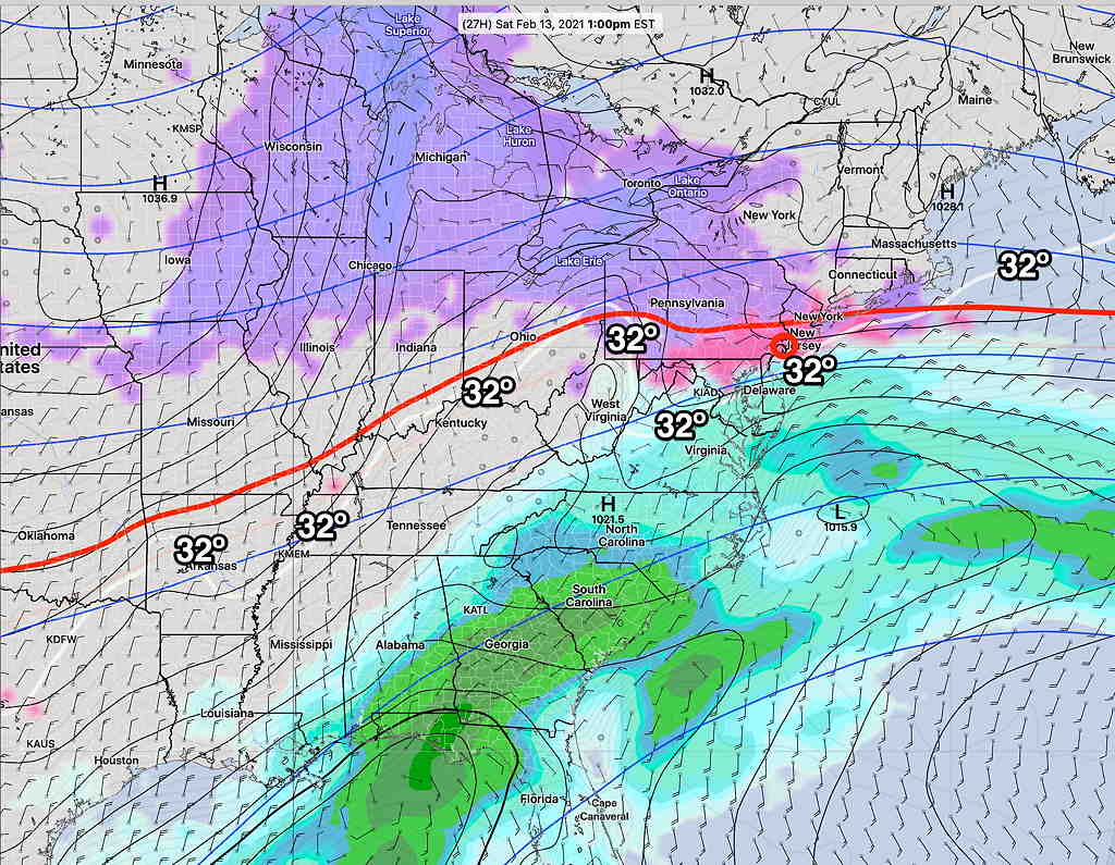
Low pressure will approach later Monday and affect our area Monday night into Tuesday morning. Instead of a coastal storm as forecast last week, Monday into Tuesday’s storm will move up the Appalachian mountains and no coastal development is expected.
GFS combined surface forecast Monday 8 PM (Click on image for a larger view.)
According to the Model Blend (NBM), surface temperatures will be above freezing as early as the early afternoon Monday and remain above freezing. Any sleet or mixed rain during the late afternoon shouldn’t accumulate.
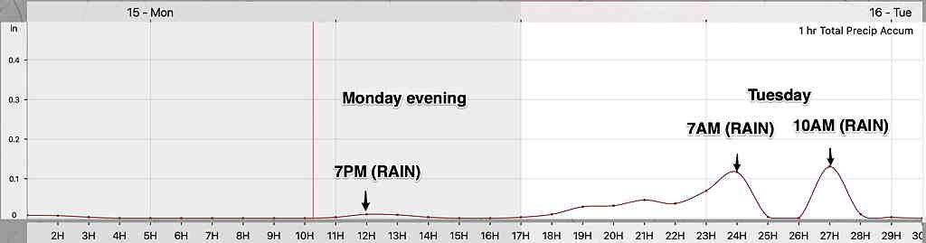
I’m always looking for ways to convey the forecast more succinctly. What might best capture this event is a simulated radar time-line (a “meteogram”) showing light possible mixed precipitation before 8 PM, then increasing heavier precip until 9-10 AM Tuesday.
NAM simulated Radar Meteogram. Any precip before 8 PM Monday will be extremely light. Heavy rain 0.8 inches of water! (Click on image for a larger view.)
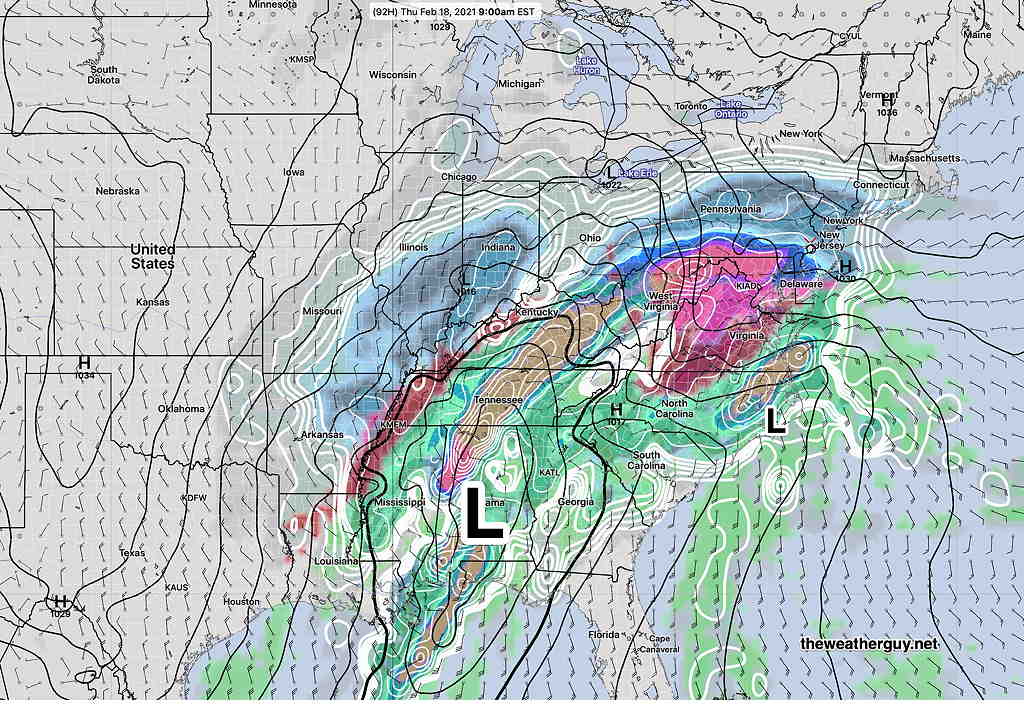
Of greater interest is a large storm expected beginning Thursday morning. Another complex precip event which may begin as snow, but the GFS is pointing to secondary low pressure development off the coast which may bring a change back to all snow. Much uncertainty with this storm.
GFS Model 9 AM Thursday (Click on image for a larger view.)
Those of you getting tired of this weather can look towards next week, where the long range models are showing milder and less stormy conditions taking hold.
Forecast Updated Sat 5:21 PM —  The light freezing rain will continue through this evening with a heavier batch moving through about 10 PM.  Precip tapers off towards morning Sunday.


For Sunday, just cloudy in the morning and the HRRR has some brightening skies in the afternoon.

Another batch of wintry precipitation midday Monday, likely in the freezing rain/sleet variety that will change to heavy rain by Monday night.  Stay tuned for more updates.
Forecast Updated Fri 9:07 PM —
Tonight’s (00z) models are just becoming available. The HRRR is showing a light coating of snow during the late morning Saturday before a changeover to light sleet and freezing rain. The 00z Model Blend has this happening early to mid morning, while most models have some light snow/sleet/freezing rain between 11 AM and 2 PM.
The SREF shows all light sleet/freezing rain with no snow. A few weeks ago, the SREF was the only model to get the precip type (PTYPE) correct.
All models have only 0.05 to 0.10 inches water equivalent, so we’re talking about light precip. Nonetheless, if it’s freezing rain, it can be a travel issue, especially when it continues after sunset. (We’re getting to the point in the calendar year where higher sun angle and solar “insolation” through clouds can help melt precip on dark asphalt surfaces.)
Freezing precip ends around daybreak Sunday. Sunday still looks very cloudy and somewhat milder. High temp 37.8º ± 1.7º
Added Fri 10:35 PM : Tonight’s NAM and HIRESW-ARW have some breaks of sun midday Sunday.
We may luck out with the storm mentioned in my earlier post for Monday into Tuesday. Some models are showing it will be mostly rain here.
posted Friday afternoon…
Cold surface temperatures with warmer flow at 3000 feet will be a setup for freezing rain and sleet Saturday into Saturday night. Another light freezing rain/sleet/snow event Sunday night and a more significant storm for Monday night into Tuesday!
Low pressure moving off to the south and a front to our west will maintain sub-freezing surface conditions, but the wind flow above 3000 feet will keep temperatures too warm for snow on Saturday.
SREF Short Range Ensemble Forecast For Saturday 1 PM Low pressure moving off to the south and a front to our west will maintain sub-freezing surface conditions, but the wind flow above 3000 feet will keep temperatures too warm for snow on Saturday. (Click on image for a larger view.)
Saturday:
Cloudy early morning with darker, lower clouds by afternoon.
Very light precipitation is predicted by most models (a few hundredths of an inch of water), but it will fall as freezing rain and sleet for the immediate Philadelphia area.
The first period of precip expected late morning and early afternoon. Another period of light mostly freezing rain/sleet later afternoon and evening.
SREF Precipitation type 8 PM Saturday (Click on image for a larger view.)
Slippery conditions are ikely with ice accumulation Saturday evening and night.
High temperature Saturday 27.7º ± 2.2º Blue Bell.
Sunday:
Sunday starts with the same dark, low cloudiness, but the low level clouds will lift to mostly mid-level cloudiness by the afternoon. No sun expected. We should reach a high of 36º± 1.7º, which could be our high temperature for the week.
Forecast uncertainties: There’s a range of values for the quantity of precipitation falling (QPF) as a mix for Saturday into Saturday night. While most models have things on the very light side, freezing rain can be very problematic if large QPF values allow buildup on power lines and tree branches.
Additional light freezing rain Sunday night!
A significant storm is expected Monday night into Tuesday with more sleet, freezing rain, possibly changing to snow.
Forecast Update Thurs 10:25 PM— Tonight’s models are suggesting that light mixed precipitation may start Saturday afternoon.
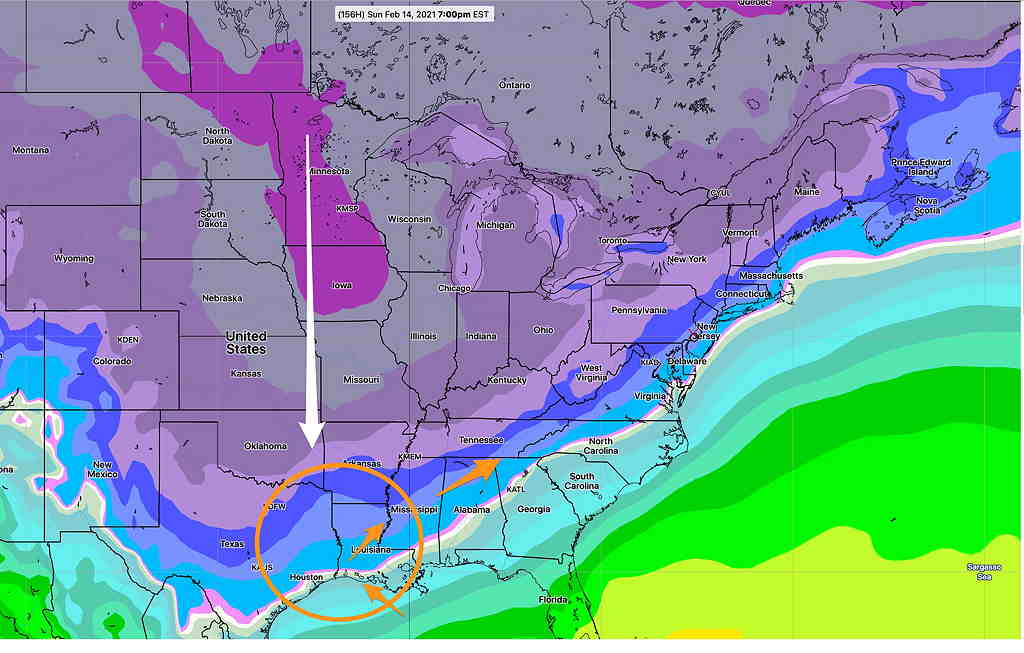
Earlier this week it became clear that an imminent plunge in cold air from Canada would be the ingredient for stormy winter weather here.
Monday’s GEFS Temperature forecast for Sunday
Today’s (Thursday’s) GEFS forecast for Monday morning. Temperatures will be in the minus 30s in the Midwest. (temperatures, not wind chills!) (Click on image for a larger view.)
Monday’s forecast for three storms hasn’t played out as expected— the plunge and amplification of the jet isn’t exactly what was forecast. The cold air is deeper than forecast in the Midwest and moving more south than southeast.
We had the first snow last night. Tonight into Friday’s storm will move south of us, missing us giving us a rest.
Saturday will be mostly cloudy and continued cold.
The next storm will affect us on Saturday night through Sunday. Right now, a light, mixed (sleet-freezing rain-rain) precipitation event is what is forecast with the main system moving to our south.
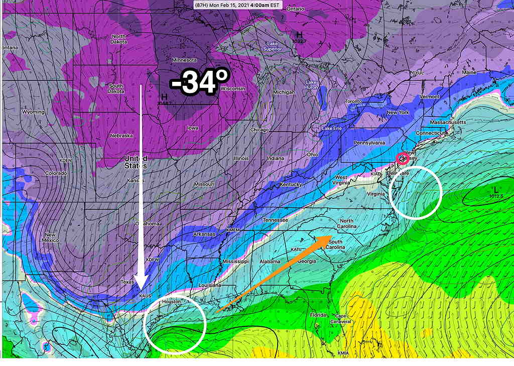
GEFS Sunday 1 PM Precipitation Type (PTYPE) forecast (Click on image for a larger view.)
We’ll have mostly sleet and some snow with this Saturday through Sunday system as warm air is expected to move in from the Atlantic. On Sunday, we may have our high temperature for the entire next week of about 37º! It would not take much for this forecast to change in to either a snow storm or a miss. But the models are in general agreement that it’s going to be a sleet mix with little accumulation.
The next significant storm is expected Monday night into Tuesday. This may give us 4-6 inches of snow. Of course, it’s way too early to predict accumulation.
Following the Tuesday storm, temperatures will get into the single digits at night.