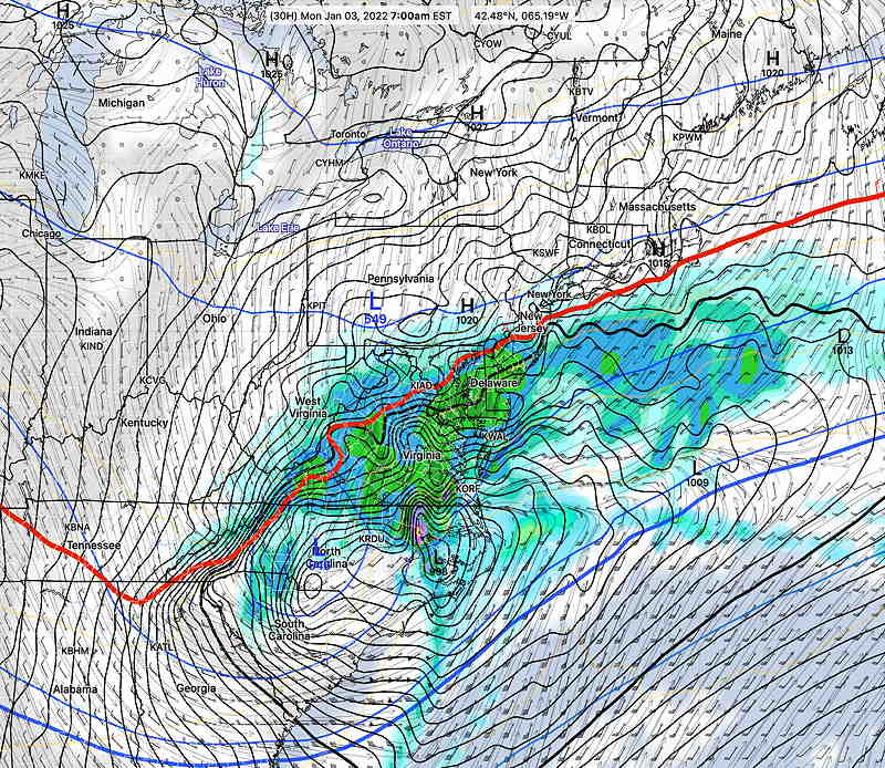
First, of course, is the NAM model, while being a late-comer to the idea of snow in NJ, accurately predicted the northern and western cutoff of the snow. 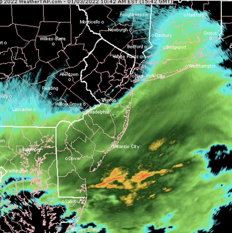
The NAM is a relatively older model, and NOAA stopped developing it further in 2017 to devote its resources to newer models. But when it comes to snowstorms in Philadelphia, the NAM still has a unique advantage.
As I said several times over these past few days, “Never ignore the NAM” model, even when it’s an outlier. But I have to admit, I was reluctant to go fully with it.
Another thing I wanted to point out. Right across the river in NJ, they’re having a major snowstorm. Where were the regular TV and radio weather people on Friday/Saturday regarding this storm? I watched one of the Saturday 6 o’clock evening news shows. Hardly a peep about this. Driving late afternoon Saturday , listening to our local news radio station, not a word about this storm. I can imagine that to many, it probably seemed like the storm came out of nowhere. But it didn’t. The potential of this storm was evident last Friday and a possibility last Tuesday.
Finally, this is the second storm in two weeks where the new GFS (version 16.x) has over-predicted snowfall for our area. While it got the large scale aspects of the storm correct, important details were off. Something is not right.
Anyhow, I love predicting the weather and the snow, but I really don’t like the snow after its fallen. So I’m not at all disappointed that I’m not digging out the driveway right now.
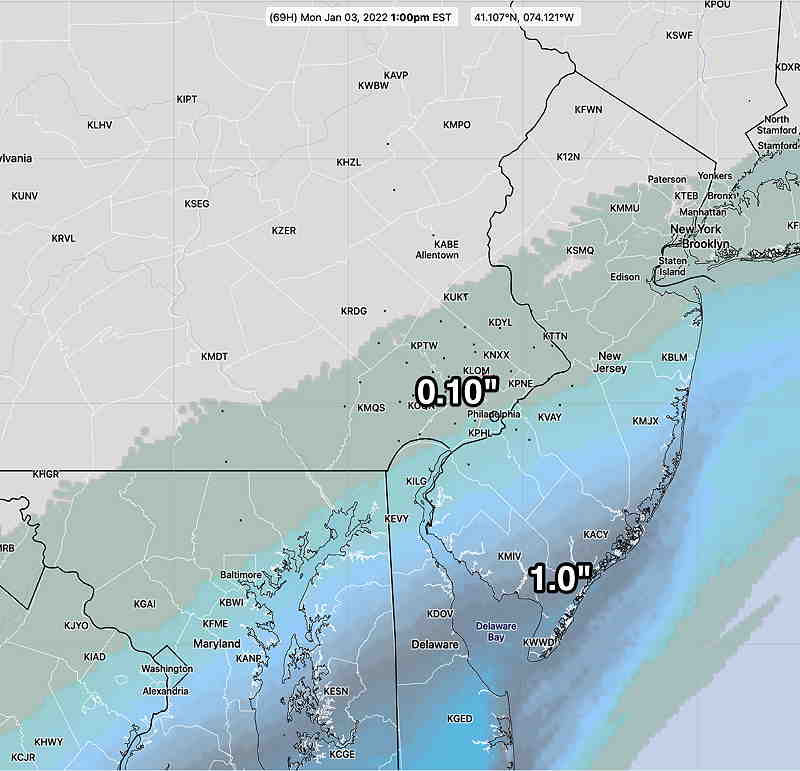
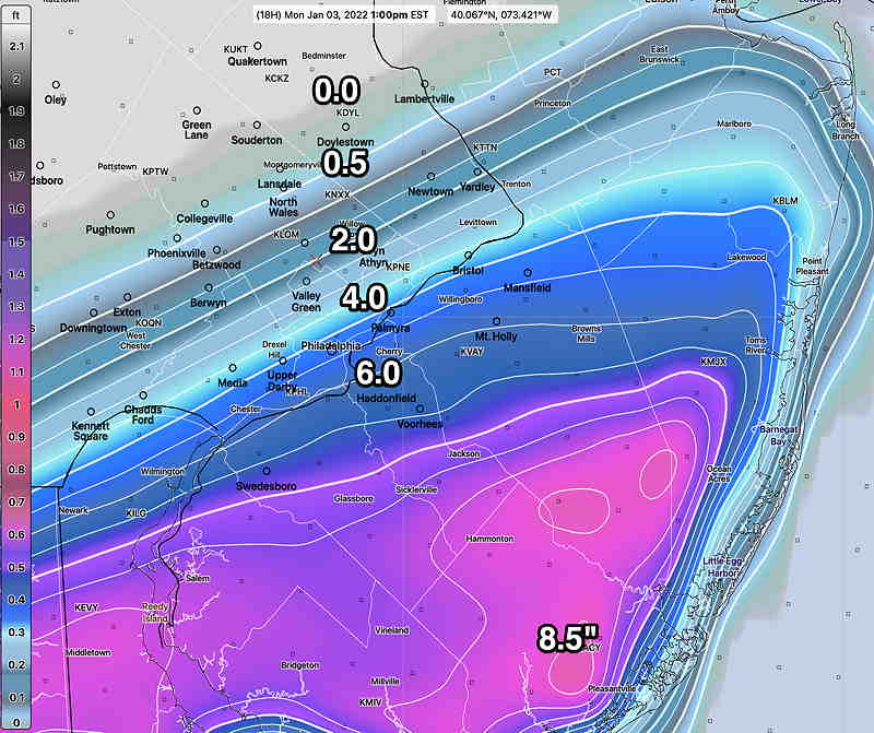
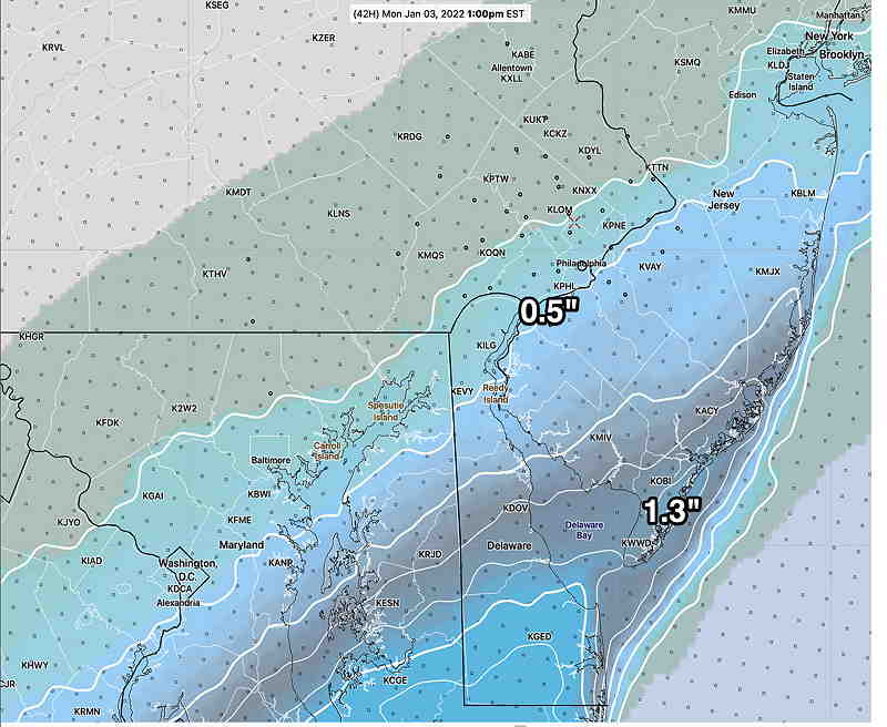
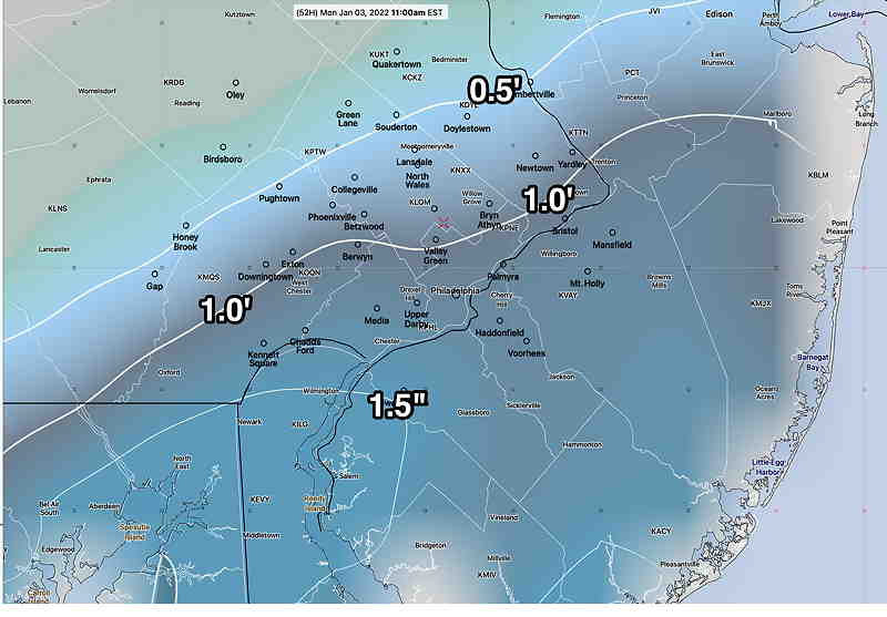
Based on MRMS data and a 10:1 ratio, here’s likely snow totals to 1 PM:
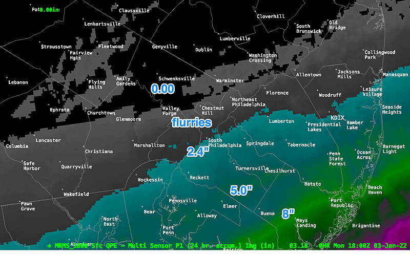
Update Mon @ 9:00 AM — The radar image at 9 AM has not changed appreciably from that posted below one hour ago.
For new visitors to this site, this is my mantra when it comes to snowstorms in Philadelphia—
“Never ignore the NAM”
So here’s the very latest NAM snow totals—

While I’m at it, here’s some other models from this morning.
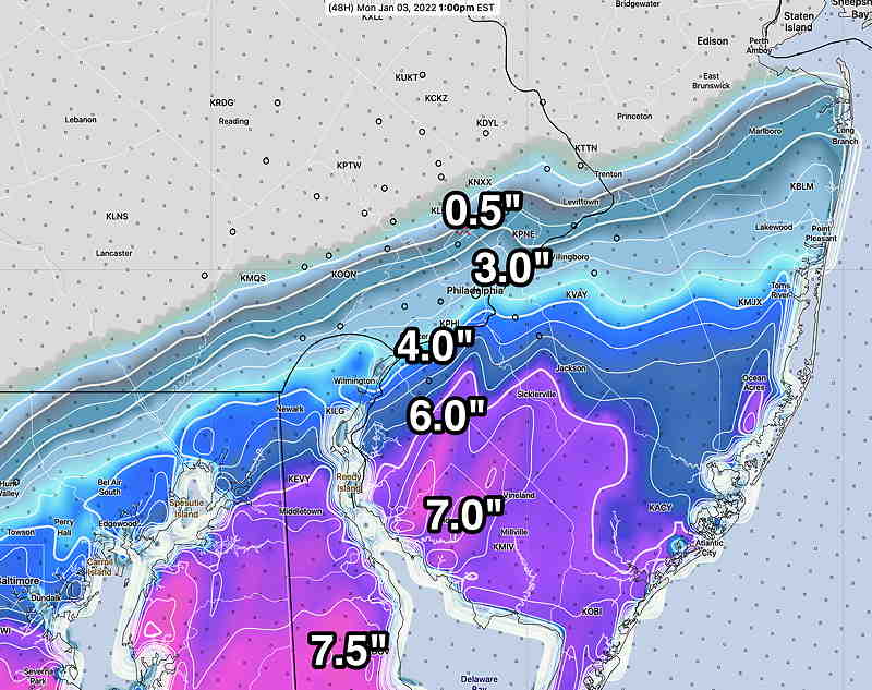
The latest HRRR snow totals just became available—

The Model Blend (NBM) latest forecast—

Update Mon @ 7:43 AM— Next major model update of the HRRR becomes available around 8:30 AM. Next update of NAM-NEST about 9:15 AM. I’ll update this forecast about 9:30 AM.
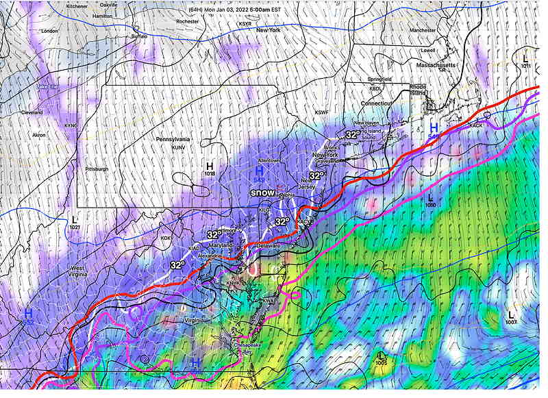
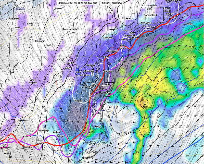
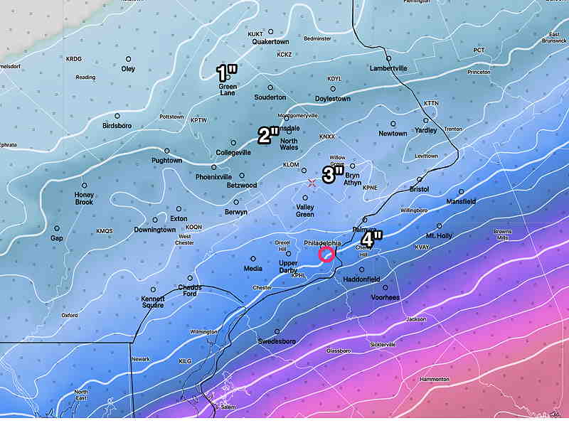
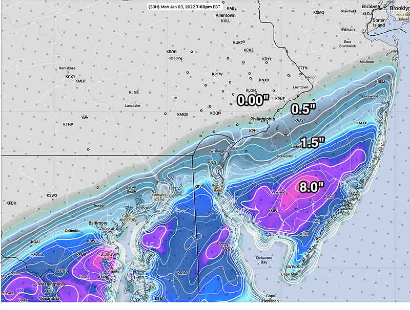
Here’s the latest radar showing the sharp cutoff of snow, best predicted by the NAM and NAM-NEST—
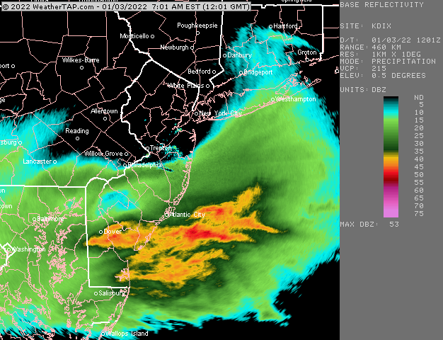
Update Mon @ 7:16 AM — Last night’s / early morning models – HRRR and NAM maintain the sharp cut off in snowfall from Philadelphia westward. Here’s yesterday’s NAM graphic. (I’ll update with a new graphic shortly). Here’s the latest NAM NEST showing little to no snow just west of Philadelphia.
“Never ignore the NAM”
Update Sun @ 11:13 PM — Tonight’s GFS
And newer NBM Model Blend ( but the NBM graphic with the range of snow totals is the better forecast.)
Update Sun @ 9:30 PM — It’s time to make a forecast. The early evening models just became available. Tonight’s NAM has finally moved into the category of having snow in Philadelphia and its snow totals are close to those of the more modern models, the HRRR and the NBM.
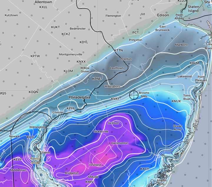
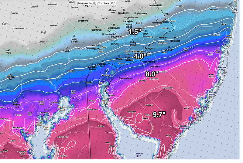
So here’s the forecast, best represented by tonight’s 00z model blend (NBM). Snow starts about 8-9 AM and ends about 1-2 PM in and around Philadelphia. Earlier start in NJ and ends later.
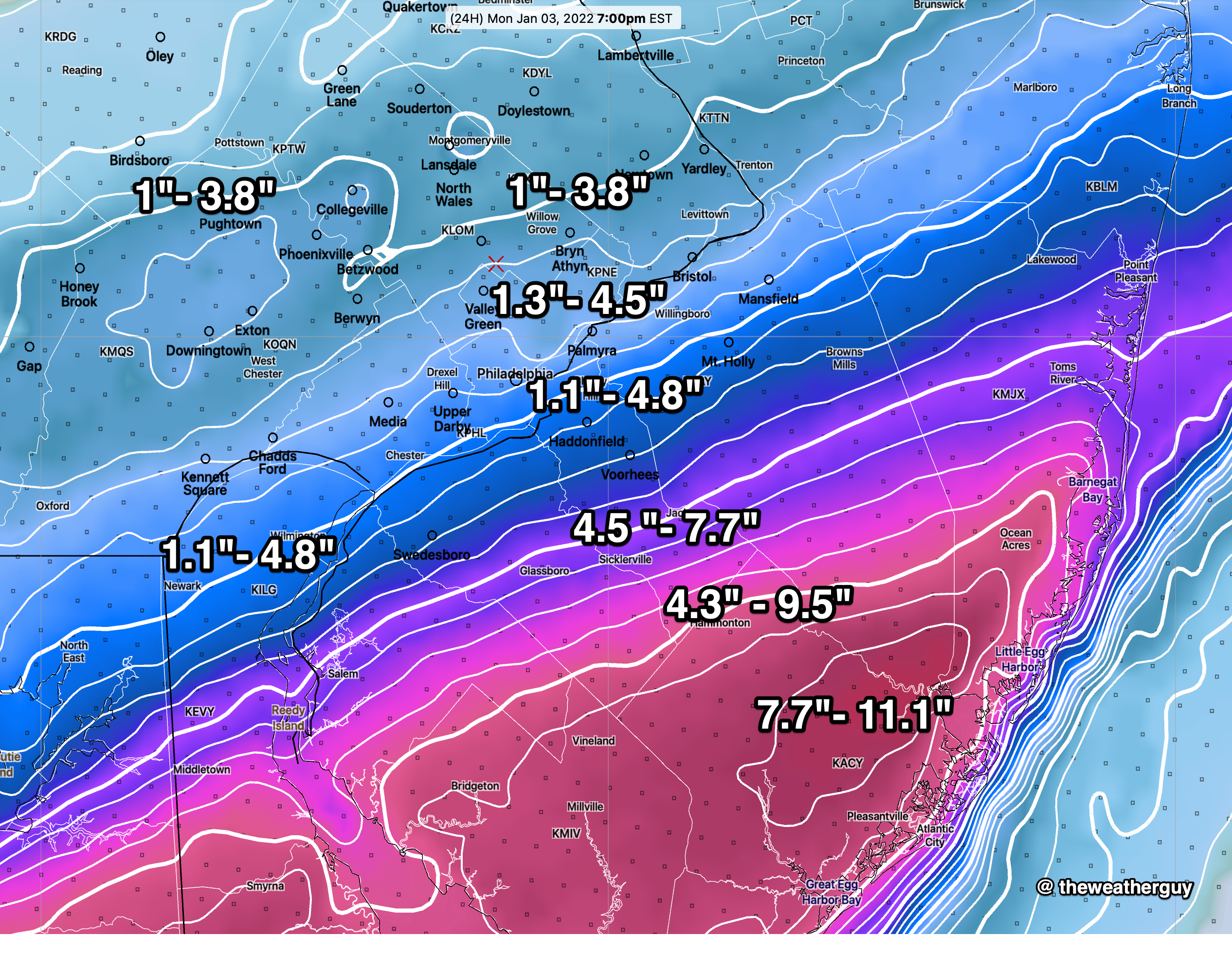
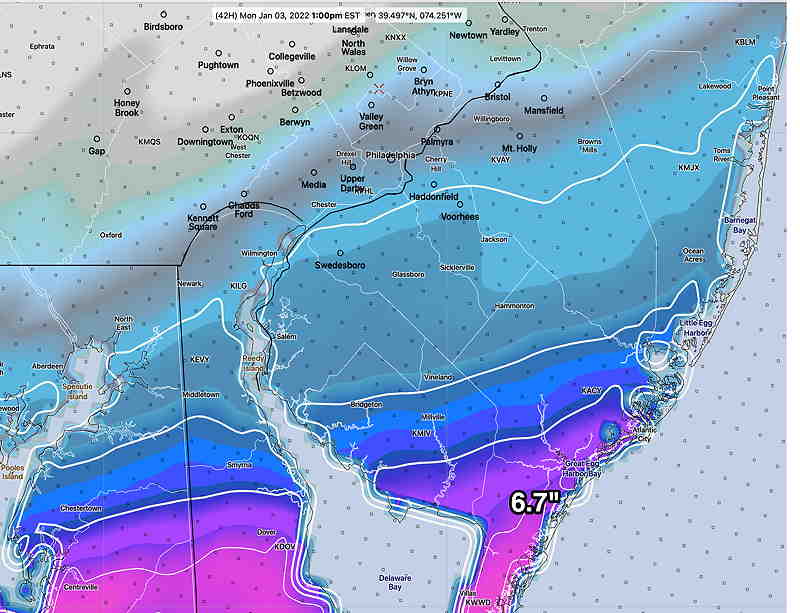
The snow totals forecast includes a range to represent uncertainty and the range shown is the 25th and 75th percentile snow totals—
I’ve updated this graphic to be higher resolution and easier to read. Click for larger view.
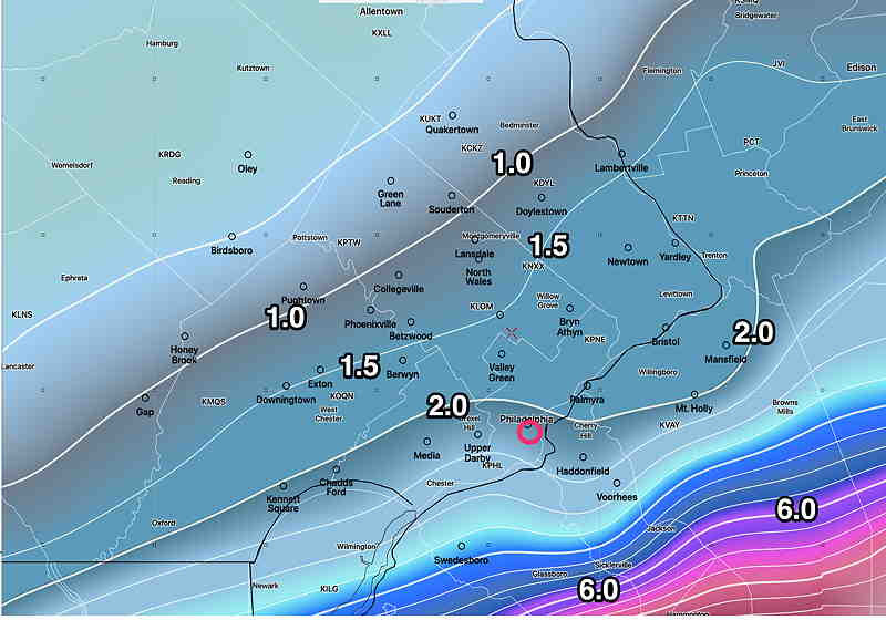
For those of you who like more deterministic forecasts, here’s the latest HRRR (00z)—

Here’s tonight’s NAM which shows a sharp cut off to our west—
I think that does it! I’ll look at the GFS which becomes available about 10:45 PM. But I think I’m going to leave this forecast with the NBM, unless the GFS shows something wild.
I’ll probably do an update tomorrow morning.
Oh… one more thing.. the SREF model has obscene amounts of snow falling tomorrow. I’m going to ignore it.
Update Sun @ 5:32 PM — There’s still uncertainty in the snow forecast for Monday.
The latest GFS (18z) still maintains a forecast of accumulating snow for Philadelphia—
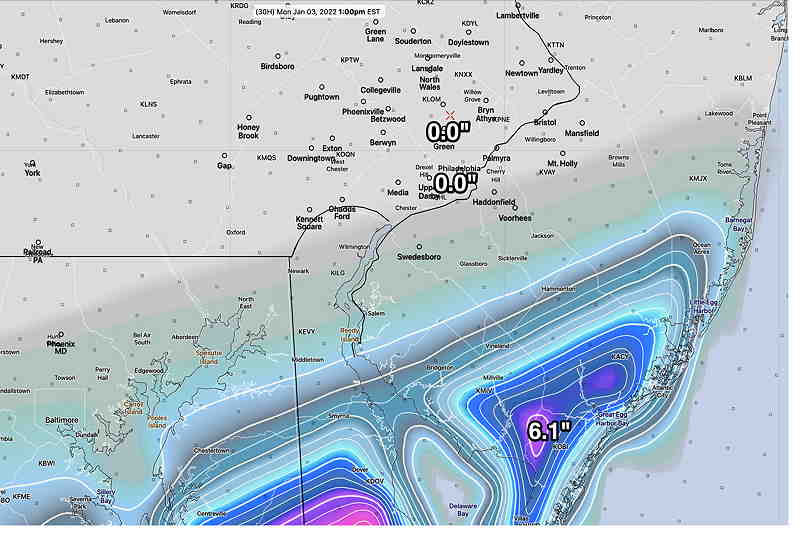
Here’s the NAM-NEST with most of the immediate PHL area getting little to zero—
As I posted just two hours ago, I’m leaning towards the NAM with little to no accumulation expected in Philadelphia, but I have to confess, it’s a leap of faith since most (but not all models) have some snow here.
The next NAM model will be available about 9:05 PM tonight. The GFS will be available about 10:45 PM. I’ll be updating this evening. Stay tuned.
Update Sun @ 3:10 PM — Latest HRRR has made a major shift, with no snow in Philadelphia. Previously, the HRRR has been in the high westward accumulating camp.
The latest NAM has a similar profile with no snow in Philadelphia and accumulating snow in southern NJ.
“Never ignore the NAM”

So despite all the fancy models, graphics and statistical jargon, I’m leaning towards the NAM with accumulating snow staying east of Philadelphia.
Update Sun @ 2:30 PM — An Eagles half-time update. The latest GFS, GEFS and SREF still have extremely high snow totals, but as you can see below, there is quite a high uncertainty and spread in possibilities, as shown by a high standard deviation (sd).
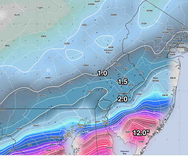
The NAM and a few HIRESW versions have close to zero in Philadelphia, but high totals in Cape May county.

Stay tuned…
Update Sun @ 9:12 AM — Long time follower’s of my blog may recall that I have a ‘saying’ when it comes to snow storms here—
“Never ignore the NAM”
Here’s the current NAM which has been anything but consistent with this forecast. Nonetheless, we can’t ignore the latest NAM’s 0.00″ total for Philadelphia—
Update Sun @ 8:58 AM — Some early morning models coming in. The latest NBM has snow starting before daybreak and ending about noon here in Philadelphia, but as late as 4 PM in eastern NJ.

Latest HRRR 12z just available at 9 AM
Update Sun @ 7:18 AM — Last night’s models continue with the possibility of a snowfall for Monday morning, especially for South Jersey.
The NWS forecast office in Mt Holly just posted this last earlier this morning —
"A major change in the forecast has occurred,
at least for southern portions of the area. A potentially
significant snowstorm is now expected to impact portions of the
region Sunday night into Monday. This is a rapidly evolving forecast
and users should monitor the forecast closely through the course of
today as additional changes, potentially significant, are possible."
Numerous models have joined the trend, first set by the GFS. Even the NAM and NAM NEST have moved somewhat towards a possible snowfall.
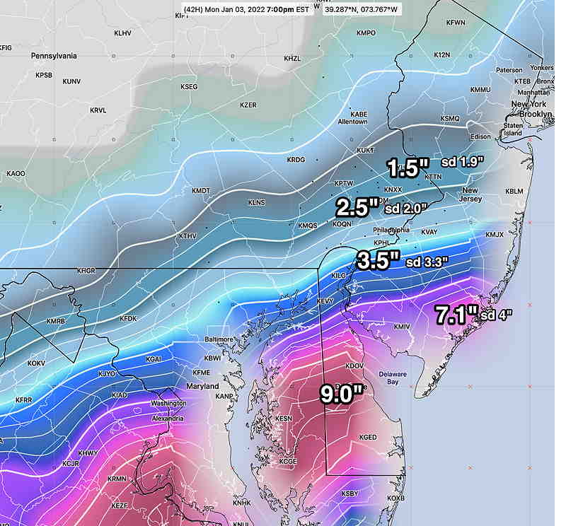
Here’s the latest GFS ensemble forecast (GEFS). The GEFS consists of 30 “perturbations” and a “control” of the GFS model. (This statistical approach, based on chaos theory, tries to compensate for inherent errors in initial conditions and measurement of data, data assimilation and numerous other issues with numerical weather prediction.)
The 30 variations or perturbations allow for quantification of potential error and uncertainty.
Here’s the latest GEFS snow forecast with sd (standard deviations)—
Stay tuned for updates today.
Update Sat @ 10:11 PM — It hasn’t gone unnoticed that the TV/radio weather people haven’t really mentioned anything about the snow possibility for our region on Monday morning. I’m truly perplexed by it. But I guess that’s why you’re here reading this blog.
I must mention that the NAM, NAM NEST and ICON models have shown zero snow until this evening. ( They now show snow in southern NJ only.) Very strange to have such a wide divergence of forecasts.
Here’s tonight’s HRRR model, which continues to show snow, as does the NBM and the SREF.

With all these models, the most likely forecast is snow in Southern New Jersey and a rapid taper to zero just west of the city. The surprise would be if the SREF just above is correct.
Update Sat @ 4:18 PM — I have more interesting data to share and chew on regarding snow early Monday. The most recent run of the HRRR (which forecasts out 48 hours) has more than moved in the direction of the GFS regarding possible snowfall for Monday. Here’s the latest HRRR snow totals for Monday morning—
Several models, including the Canadian GEM, the Canadian GEPS and the ICON Ensemble (ICON-EPS) have moved in the direction of the GFS with accumulating snow, especially for South Jersey. Their snow totals have a similar profile, decreasing towards Philadelphia, with maximum snow of 2.0 inches in Cape May County.
The possibility of snow has been a ongoing possibility since since I mentioned it in Tuesday’s blog post. It’s been on again, off again. The above HRRR is the latest, possibly the most extreme possibility.
If you’re just joining this this blog forecast discussion, I recommend you read the background info below.
Stay tuned.
Update Sat @ 11:10 AM — The latest GFS model just became available minutes ago. Hard to believe (literally), but here’s the snow the GFS is predicting by Monday morning. I’m just throwing this out there —
Update Sat @ 9:58 AM — The period between Sunday and Monday is just coming into range of the higher resolution short range models.
Saturday —rainy and mild.
Sunday- Cloudy with a thinner cloud deck into the afternoon. Very mild until the front moves through.
The front moves through between 3 and 5 PM. Gusty winds with highly scattered light sprinkles as temps begin to drop.
Despite last night’s GFS model’s snow prediction, the other models all keep any precipitation to our to our far south and east. Even the NBM has removed snow from its forecast. So no snow late Sunday night into Monday.
Updated Sat @ 8:10 AM — No significant change in Saturday’s forecast. The spotty light rain drizzle in the morning today will become more steady by the afternoon.
The trend for late Sunday is for any measurable snow to be in Delaware and southern NJ (Cape May).
The GFS still has measurable snow here by Monday morning. The higher resolution short range models have no snow in our neck of the woods. The GFS ensemble still shows light precipitation falling as snow before daybreak south and east of the city, but no accumulation around PHL. (As was the case last week, the GFS over-predicted snow here. I’m going to lean away from the GFS this time around.)
With all these models, the most likely forecast is snow in Southern New Jersey and a rapid taper to zero just west of the city. The surprise would be if the SREF just above is correct.
The possibility of snow has been a ongong possibility since since I mentioned it in Tuesday’s blog post. It’s been on again, off again. The above HRRR is the latest, possibly the most extreme possibility.
If you’re just joining this this blog forecast discussion, I recommend you read the background info below.
Despite last night’s GFS model’s snow prediction, the other models all keep any precipitation to our to our far south and east. Even the NBM has removed snow from its forecast. So no snow late Sunday night into Monday.
The trend for late Sunday is for any measurable snow to be in Delaware and southern NJ (Cape May).
The GFS still has measurable snow here by Monday morning. The higher resolution short range models have no snow in our neck of the woods. The GFS ensemble still shows light precipitation falling as snow before daybreak south and east of the city, but no accumulation around PHL. (As was the case last week, the GFS over-predicted snow here. I’m going to lean away from the GFS this time around.)
Update Thur 6:40 PM— The GFS forecast below for Sunday is currently an outlier, with the European (ECMWF) Canadian (GEM) and German (ICON) models have the precipitation missing us, exiting to our south. This is an evolving forecast.
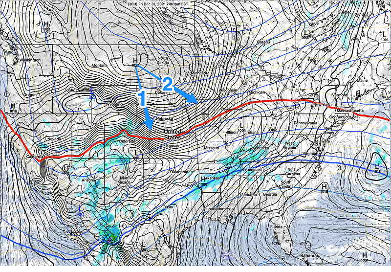
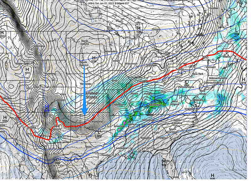
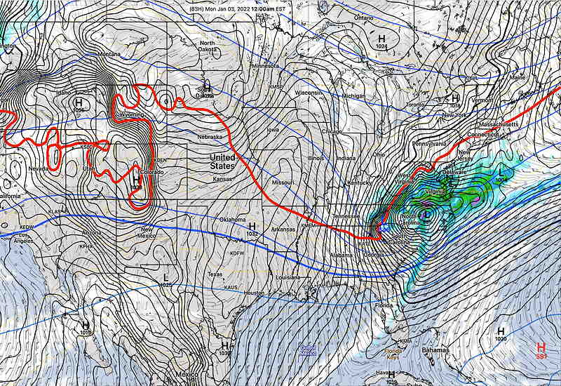
Cold air, which has been conspicuously absent this past month, has been building up in northern Canada and indications are that it has reached enough critical mass to plunge (at least temporarily) down into the continental US and into our area by the end of this weekend.
A strong frontal boundary has developed separating the very cold air from unseasonably warm air. Low pressure systems have been developing and ejecting towards us in this warm sector, giving us the clouds and occasional showers these past few days.
Currently, the cold air is expected to plunge southward and then eastward. Depending upon how far southward vs eastward will determine the shape of the jet stream and the path of low pressure expected to develop on the front.