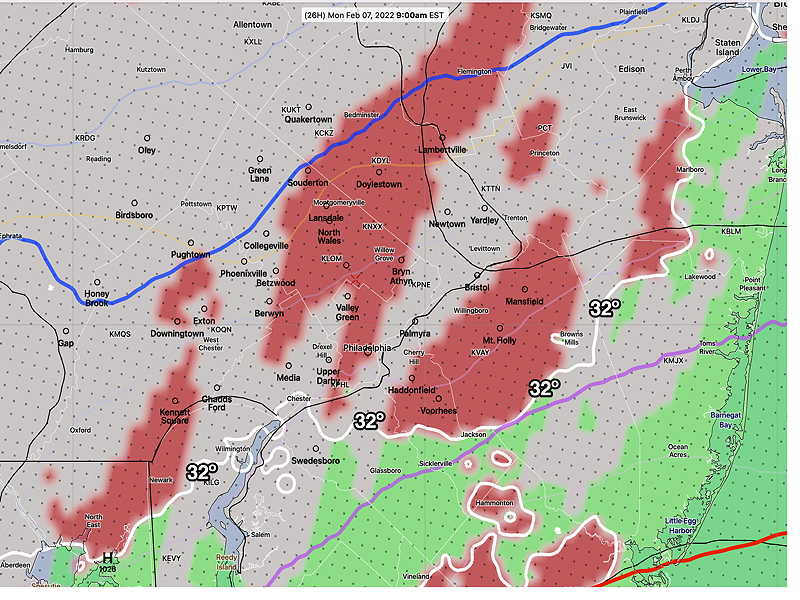
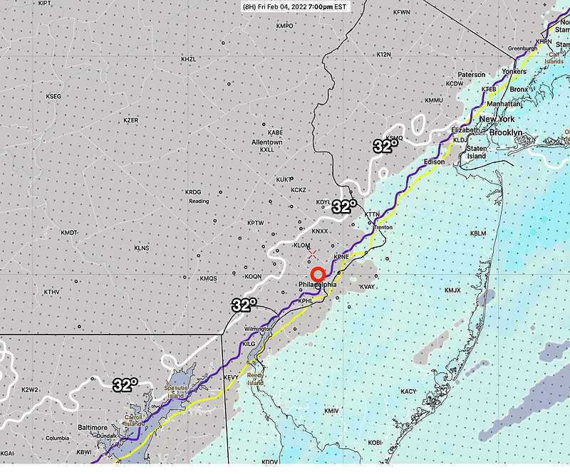
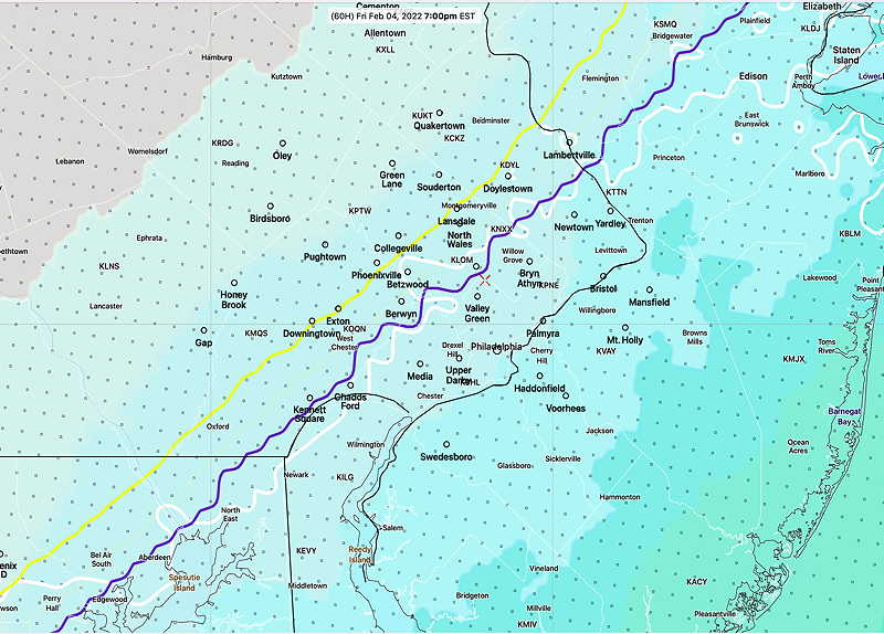
Update Sun @ 9:12 AM — Regarding the coastal storm passing to our east Monday evening, this morning’s HRRR, NAM-NEST and HIRESW have some light freezing rain moving in Monday morning during the rush hour, well in advance of the main low pressure center.
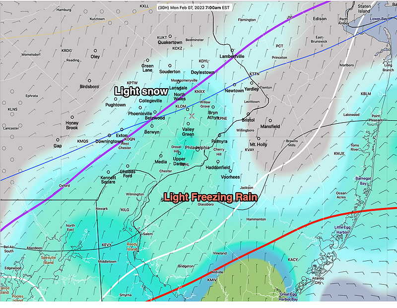
This morning’s 12z HRRR forecast for Monday at 9 AM. Freezing rain in red. (Click on image for a larger view.)Today’s 06zECMWF forecast for Monday 7 AM, showing light freezing rain north of the 32º (white) contour and and light snow north of the (purple) 1000-850 mb thickness line. The ECMWF suggest that this starts before daybreak. (Click on image for a larger view.)
The main low is still expected to pass to our east with the edge of the precipitation shield being rain in our area later Monday afternoon and evening.
Update Sat @ 10:48 PM — Tonight’s models continue to show Monday evening’s coastal storm barely brushing the Philadelphia area during the early evening. Thermal profiles are trending warmer—too warm for snow.
Update Sat @ 9:48 AM — No significant change in this weekend’s forecast.
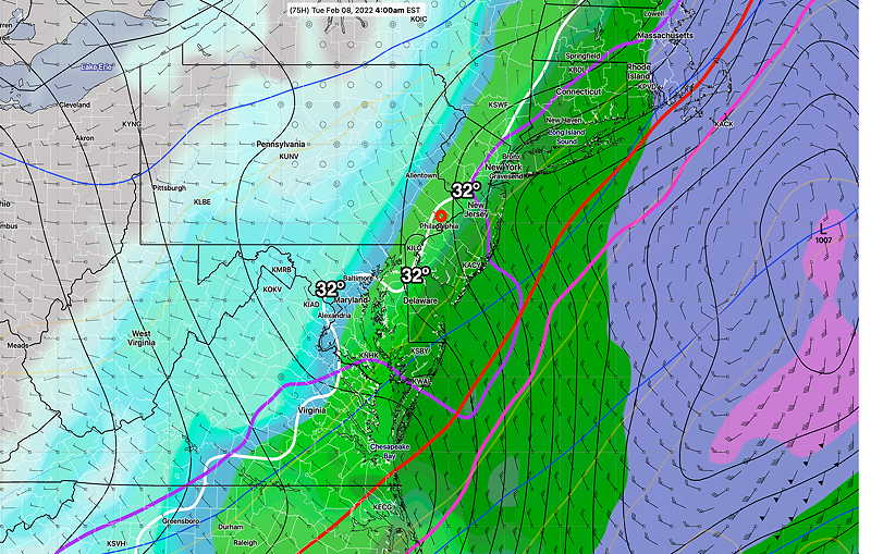
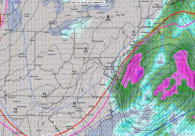
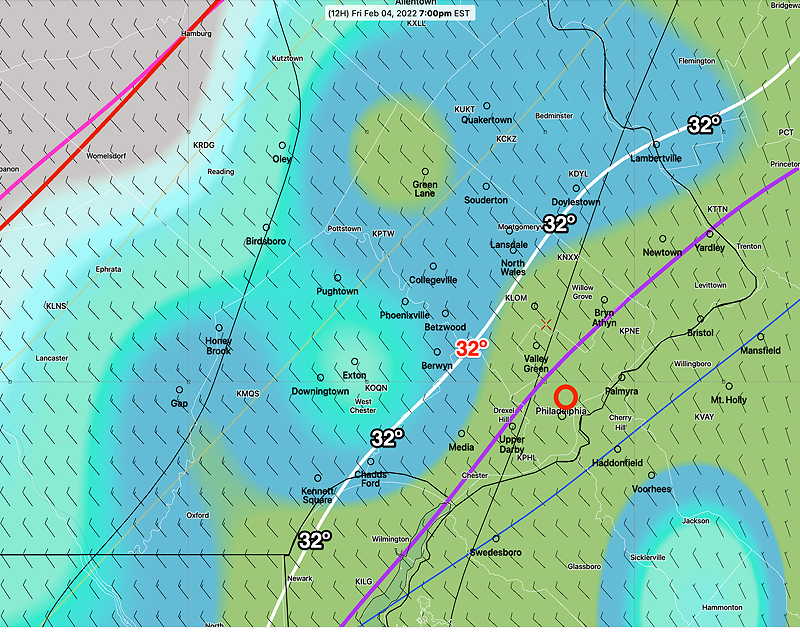
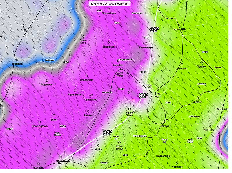
The coastal system expected to move near us later Monday night into Tuesday morning is still expected to brush us with precipitation.
Temperatures in the immediate PHL area will be marginally too warm, so any precipitation will fall as wet snow/ rain mix at best; moisture extending beyond the immediate Philadelphia area may fall as snow flurries or light snow showers. While there is currently good agreement with the models, the trend over the past two days has been to be slightly closer to the coast. I’ll keep an eye on it.
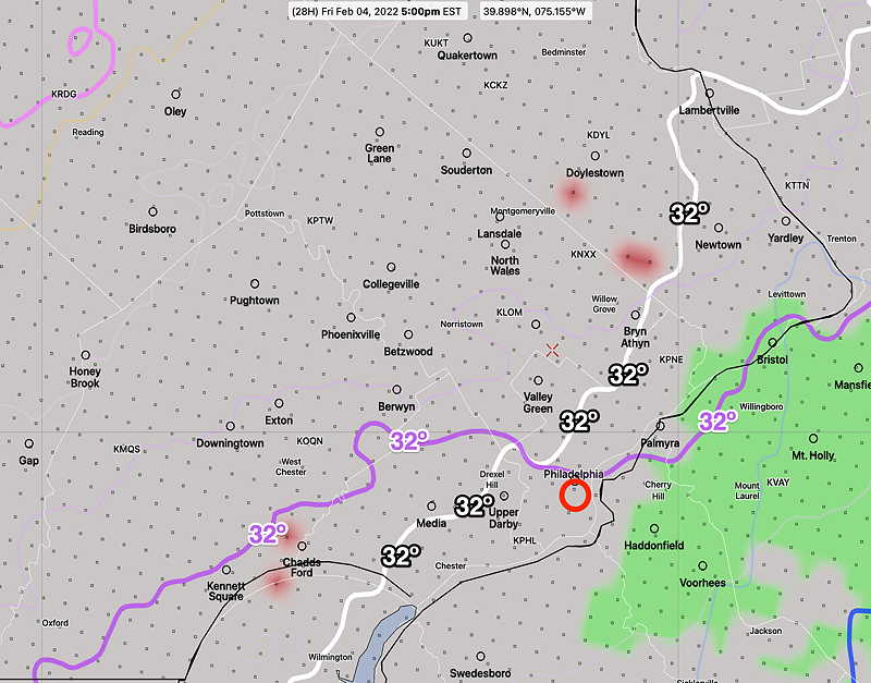
GEFS mode forecast 4 AM Tuesday (Click on image for a larger view.)
Cold high pressure will build in behind the rain that moved away almost on schedule as forecast. A straight forward forecast for the weekend.
Fair and very cold, with windy conditions, especially in the afternoon. High temperature 29.1º ± 0.9º. Wind chills will be in the teens. NBM model, Blue Bell.
Previously Posted Fri 7:52 PM —
Sunday
Sunny, occasional fair weather clouds. Much less windy. High temperature 33.0º ± 2.2º. NBM model, Blue Bell.
Looking Ahead…
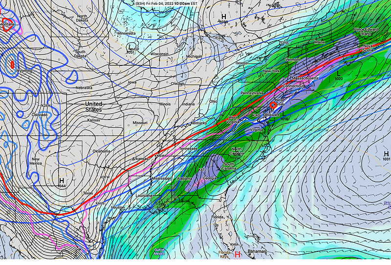
Of interest is a low pressure system that will move off the coast Monday night into Tuesday morning. Most models have it missing us, possibly brushing the southern NJ shore with snow showers/flurries for us. I’ll keep an eye on it.
This afternoon’s ECMWF 18z forecast for Tues 7 AM (Click on image for a larger view.)
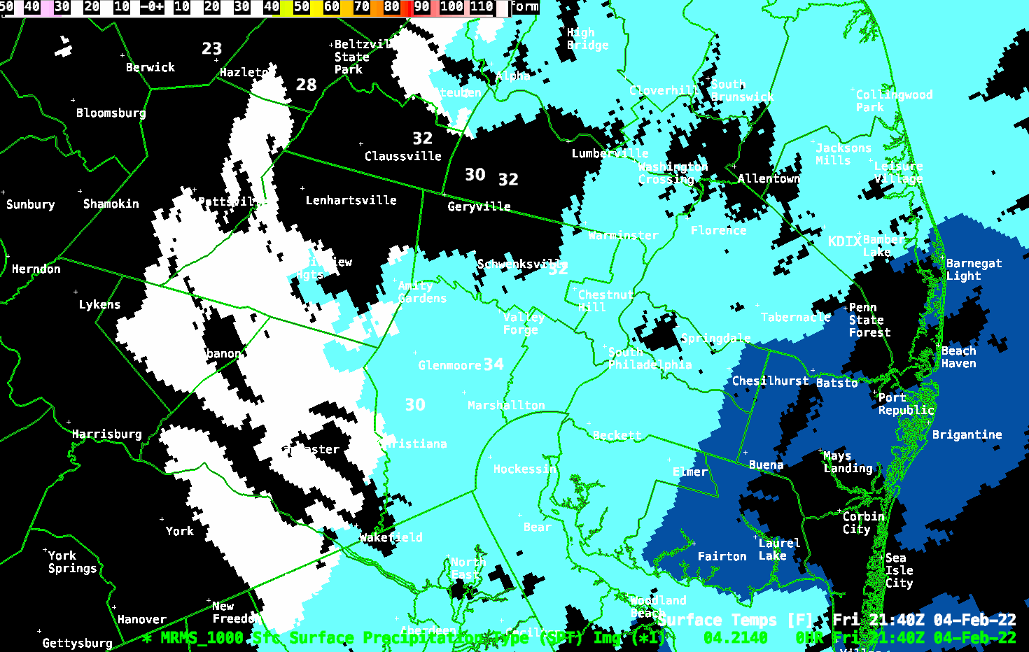
Update Fri @ 4:54 PM — I sure hope my forecast is correct. The temperature is dropping. The latest MRMS shows the back end of the precipitation near upper Montgomery County is changing to snow. Most areas still rain or what’s called “cold stratiform rain”
MRMS at 4:41 PM The MRMS shows actual precipitation type: rain vs snow. Snow is shown appropriately as white. *Click on image to animate .* (Click on image for a larger view.) Super-imposed are current observed temperatures.
Update Fri @ 3:34 PM —
“All this rain, I hope it doesn’t turn to snow”
It won’t, at least around here. I’m sticking with the NBM and Canadian RGEM models which clearly show the precipitation departs before the cold air comes in—
This afternoon’s NBM model (16z) showing the precipitation into NJ at 7 PM with the surface 32º contour (white) just making it into Philadelphia. With the wet bub freezing temperature (violet contour) and the Bourgouin Positive Energy contour (yellow) just to our south, it would be cold enough for snow, BUT there will be NO precip falling! (Click on image for a larger view.)
I can see why there were forecasts for a change to sleet and snow. Many models had showed it a few days ago. Even today’s ECMWF shows the possibility.—
ECMWF 12z forecast for 7 PM this evening. At first glance it looks like sleet just to the west of the 32º contour, BUT precipitation displayed as a 3 hour accumulation, not radar simulation, so this is really precip that fell between 4-7 PM. Just the way it works. This is a debut graphic for me. It’s first time I’m posting a graphic of ECMWF downloaded raw grib data. (Click on image for a larger view.)
As mentioned in the caption above, after years of not being freely available, the European Center for Medium Range Weather Forecasts (ECMWF) has made their data available in almost (1 hour delayed) real-time. I never thought I would see it but like the US, Canadians and Germans, the ECMWF is participating in the “Open Data Project”.
Prior to this, the ECMWF data was limited to subscription only, on the order of > $10,000 US annually.
Update Thu @ 4:48 PM — The NAM and GFS has joined the other models in forecasting virtually no mixed/frozen precipitation in our immediate Philadelphia area Friday. This is comparable to the forecast first made by the Canadian RGEM model and our own NBM over two days ago.
Basically, the bulk of the moisture and precipitation leaves before the cold air comes in. While the NAM-NEST below shows temperatures dropping below freezing here around 5 PM, the latest RGEM has it an hour or so later.
This afternoons 18z NAM-NEST showing freezing line contour (white) and freezing line contour at 3200 feet (violet) Friday at 5 PM. The green areas is exiting rain and the widely scattered red is possible freezing rain. (Click on image for a larger view.)
Update Thu @ 7:15 AM — Last night’s models continue with the dichotomy in the thermal profiles for Friday with the GFS and NAM having the change to sleet->freezing rain->snow Friday afternoon around Philadelphia and immediate surrounding counties, while the Canadian RGEM and NBM continue with a delayed entry of the cold air until early evening after the precipitation has effectively ended. Some transition is possible in the Allentown area, but not the immediate PHL area.
I continue to lean towards the RGEM and NBM forecast which means little if any transition and little or no accumulation in the evening. Icy conditions possible later evening from pooled water freezing on roadways and sidewalks. I’ll keep an eye on it.
Update Wed @ 5:55 PM — This morning’s and afternoon’s models haven’t changed much regarding the possible transition to sleet/snow on Friday. While there are several models (GFS, NAM, HREF) that have temperatures dropping below freezing as early as 1 -3 PM in Philadelphia with a change to sleet->freezing rain->snow Friday afternoon,the NBM and Canadian RGEM keep temperatures above freezing until early Friday evening with most of the precipitation having ended.
Little or no accumulationwith this scenario in the Philadelphia area/ immediate suburbs, although icy conditions possible from remaining wet surfaces freezing over after 8 PM. I’m leaning towards this Canadian RGEM/NBM forecast. I’ll keep an eye on it.
Update Wed @ 8:57 AM — This morning’s model blend (NBM model) continues to back away from any significant sleet or snow following the cold front passage Friday.
The NBM keeps the surface temperatures above freezing until after 7 PM. The thermal profiles show a dusting/coating of snow northwest suburbs and a brief frozen mix as temperatures drop. Again little, if any, accumulation.
Today’s 12z NBM: Forecast for 7 PM Friday. Surface freezing (white line) wet bulb freezing temp (purple contour), Bourgouin Positive Energy contour (yellow line) (snow north of this line.) (Click on image for a larger view.)
Update Tue @ 4:36 PM —Today’s GFS and GEFS continue with a change to mixed precipitation Friday afternoon, following the cold front passage.
However, this is beginning to look like the event from a few weeks ago (Jan 17th) where rain was supposed to changeover to snow, but we got almost nothing. At the time, the Canadian GEM and NAM were forecasting little to no accumulation and they turned out to be correct.
Despite the GFS/GEFS continued colder forecast, today’s Canadian GEM has a couple of hours of mixed precip (sleet/wet snow) late Friday afternoon in the northwest suburbs with little accumulation.
Canadian RGEM forecast for 5 PM. Violet is mixed precipitation. (Click on image for a larger view.)
I’m leaning towards this. So I think you can forget about any meaningful snow/sleet accumulation Friday.
Previously Posted Mon 8:15 PM —
An interesting scenario is setting up for late Thursday into Friday.
First, we’ll be getting a brief January thaw in February this Thursday with temperatures reaching the low 50s.
Unfortunately, there will be considerable cloudiness with this warmup before heavy rains move in Thursday night. As much as 2 inches of rain are possible from late Thursday into Friday morning.
That’s where things get interesting. A frontal boundary will slowly move through Friday morning and surface temperatures will drop.
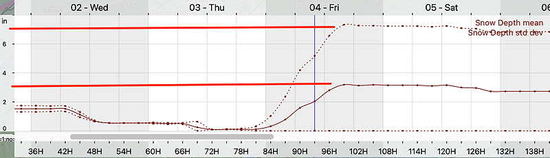
GEFS showing red 540 thickness line and approximate position of cold air aloft. Notice the white contour (32º surface temperature) is to our south along with low pressure developing in North Carolina. A wide range of possibilities from mixed precipitation to snow is possible, depending upon the development of this second low. (Click on image for a larger view.)
A second area of low pressure may form along the front and move up bringing a transition to a mix of wet snow or accumulating snow. There’s a wide range of possibilities and uncertainty with this setup.
GEFS shows a mean snowfall of 3 inches in Blue bell but with a standard deviation of of over 7″ That’s a lot of uncertainty. (Click on image for a larger view.)