Update Thu @ 10:07 AM — The rain is exiting, but cloudy damp conditions will linger throughout the day. Rain redevelops Thursday night.
Friday looks good as we’ll be in-between systems, specifically a strong cold front that moves through Friday night.
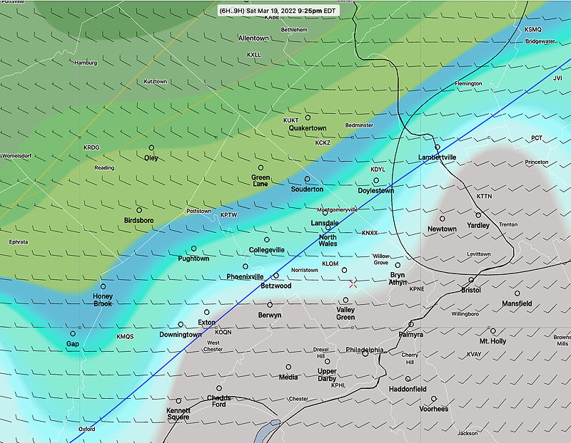
Saturday looks unsettled, windy, with scattered showers especially northern suburbs. An mid-level disturbance and upper trough will bring the showers.
Sunday looks partly sunny, still breezy and unseasonably cold.
Update Wed @ 10:22 PM — Tonight’s early models have the rain ending Thursday morning from the city westward. Very cloudy. Rain redevelops Thursday evening.
Update Wed @ 11:23 AM — With such a complex system to affect our weather over the next several days, expect changes in the forecast. As an example, today’s rain, originally expected to move in after noontime, now appears to move in after 3-4 PM.
Rainfall amounts tonight will be over 1 inch and areas in NJ will see higher amounts, lingering through Thursday.
Much of the rain Thursday will be just east of Philadelphia, but some showers are still possible in our immediate area.
The forecast for Friday looks better as some clearing is expected behind a cold front.
Saturday still looks unsettled with possible scattered showers due to an upper air trough moving through.
The complex weather pattern discussed in earlier posts starts Wednesday afternoon, with several areas of low pressure moving through. The first will be Wednesday into Thursday, then Thursday into Friday. The current timing shows the heaviest rain falling during the nighttime hours, Wednesday night and Thursday night.
There may be daytime periods Thursday and again on Friday where things temporarily partially clear. Unfortunately, Saturday is looking unsettled and showery due to an upper air low—
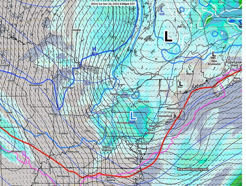
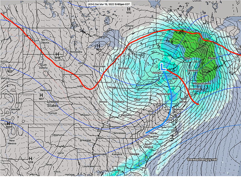
GEFS statistical mode forecast for Saturday 2 PM. The main low in Quebec Canada will have several surface lows (black L) rotating around it. An upper air low (Blue L) will bring showers to our area on Saturday. Green blue shading is rain and up north, snow. Note that the red540 thickness line is south of our area indicating chilly weather on Saturday. (Click on image for a larger view.)
Update Mon 10:43 PM— Not much change in the forecast. The complex system in the Midwest will move north of the Great Lakes while disturbances develop and move up over us from Thursday through Saturday. The complexity of this setup will prove difficult to forecast the rain and dry periods accurately. The best day looks to be Sunday, but it will be chilly. Stay tuned.
Previously Posted Sun 7:06 PM —
A gradual warmup in store for us on Monday and Tuesday. Highs just above 60º
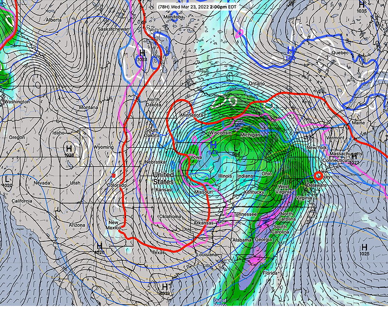
A large storm in the upper Midwest will bring rain to our area on Wednesday.
GEFS forecast for Wednesday at 2 PM. Rain expected as a southwesterly moist flow develops. (Click on image for a larger view.)
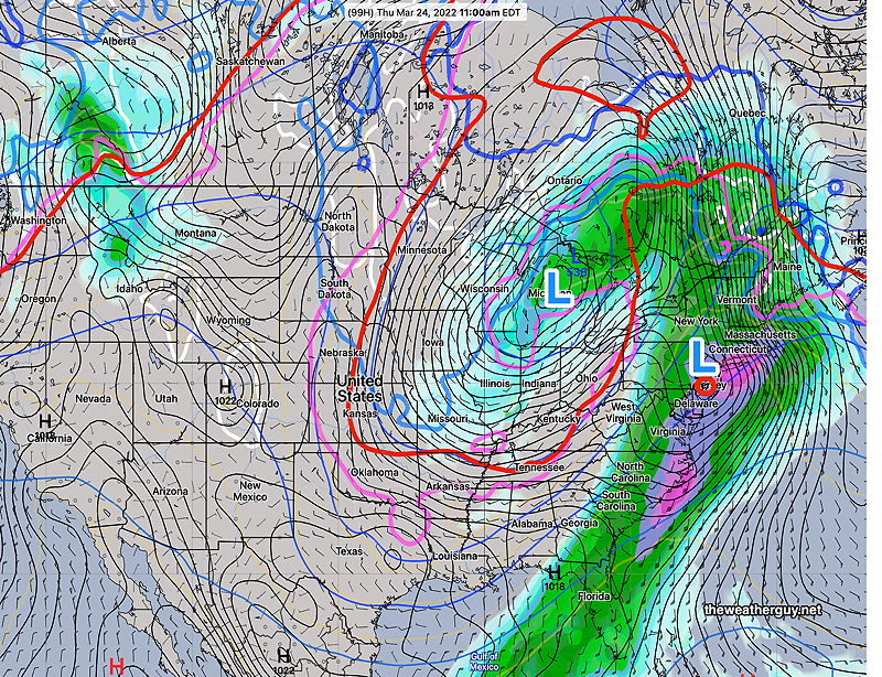
Thursday, we’ll likely have more rain as a secondary coastal low is spawned off of the main low—
GEFS forecast for 11 AM Thursday. Possibly heavy rain from this secondary low. (Click on image for a larger view.)
After a quieter day on Friday, the weekend looks to be unsettled with possibly more rain.
Update Sun @ 9:32 AM — Clouds have moved in earlier than forecast today. The GFS forecasts clouds throughout the day, becoming WINDY in the afternoon. High temp 55.5º sd 1.1º
Sat 09:43 PM Forecast Review — So, how is it possible that the models showed the storms not getting into Philadelphia, yet we had a line of thunderstorms over the past hour?
Here’s tonight’s 8 PM HRRR showing the eastward extent of its forecast rain —
Tonight’s latest (8 PM) HRRR showing the eastern extent of the forecast precipitation. Clearly the model didn’t bother to look at the radar. (Click on image for a larger view.)
Here’s the much acclaimed ECMWF forecast, also showing the rain not making it into Philadelphia—
ECMWF 18z forecast showing eastern extent of rain tonight. (Click on image for a larger view.)
The weather models are often amazing. Not so much today.
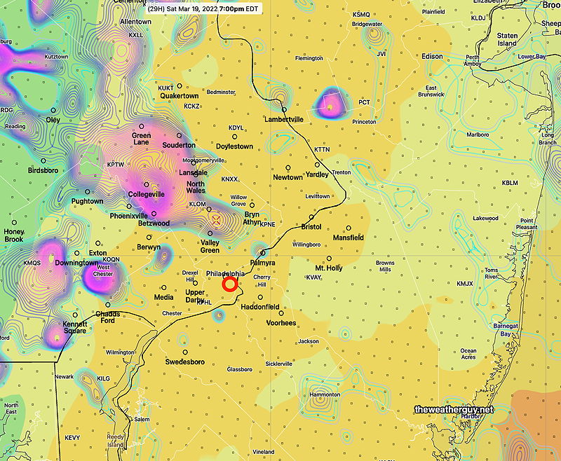
Update Sat @ 5:52 PM — As forecast in the earlier HREF graphic, showers/embedded thunderstorms are expected to stay northwest of the city. Only light showers expected to make it into Philadelphia this evening—
Earlier HREF forecast 7 PM Saturday. Vertical velocity and CAPE elevated especially northwest of the city. Thunderstorms possible. (Click on image for a larger view.)
Sunday looks sunny in the morning with cloudiness by 2 PM as a secondary cold front moves through.
Update Sat @ 9:18 AM — Today’s forecast has been a perfect example of poor model performance intersecting with delayed evening model forecast availability (especially the GFS) due to Daylight Saving Time.
There’s still a range of forecasts and uncertainty regarding degree of cloudiness today. Last night’s GFS moved away from showers this morning, but has considerable cloudiness. Showers and thunderstorms develop as early as 4 PM , peak chance about 6 PM and continue through 8 PM. If we get more sunshine, expect stronger thunderstorms.
As late as it is this for this morning’s update, the new HRRR and other models have yet to come out. The HRRR will be available by about 9:33 AM.
Update Fri @ 9:54 PM — Significant Update (Models out later due to Daylight Savings Time)
A low pressure system and its associated warm front/cold front will affect our area on Saturday. A secondary cold front moves in on Sunday.
SREF forecast for Saturday at 5 PM. Warm front to our north with cold front moving through PA. (Click on image for a larger view.)
Saturday
Clouds and showers early will end mid morning Saturday. There’s still some question how much sun we’ll see on Saturday. My earlier view was much more optimistic about some bright spots and sun. But the majority of models have low clouds and damp conditions lingering throughout the day.
Friday night’s early models just becoming available . The HRRR shows breaks of sunshine mid day in many areas. Then clouds return mid afternoon with some light scattered showers. Then sunshine possible about 5-7 PM before thunderstorms move in.
High temp 72.1º ± 1.7º Blue Bell
A cold front moves through between 7 and 9 PM. Additional showers expected to move through during this time frame. Without sunshine, lower instability reduces the chances of thunderstorms.
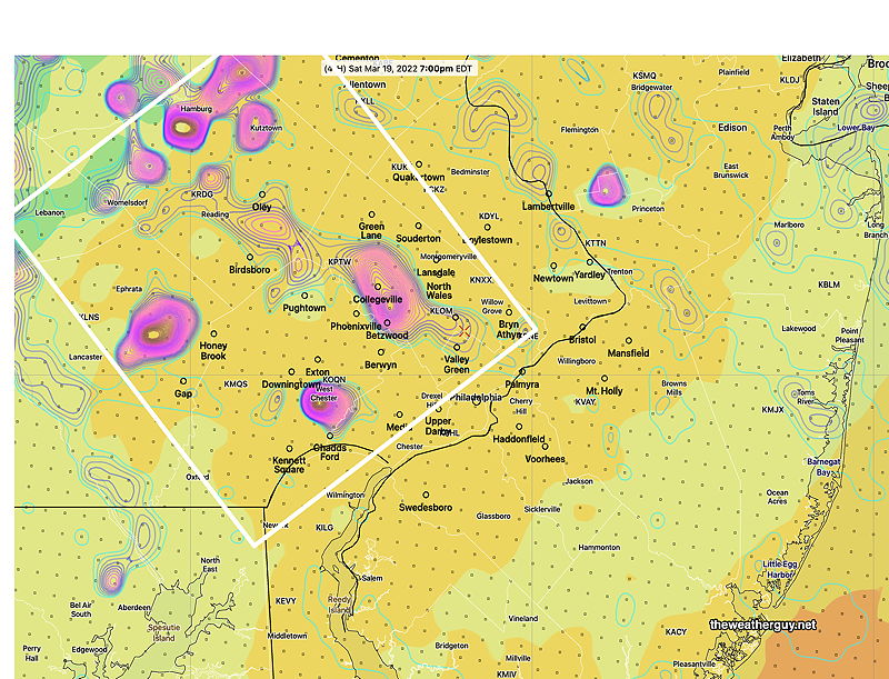
Despite the lack of forecast sunshine, the HREF is still predicting some thunderstorm activity during the early evening Saturday from 7-10 PM, especially west of the city —
HREF forecast 7 PM Saturday. Vertical velocity and CAPE elevated especially northwest of the city. Thunderstorms possible. (Click on image for a larger view.)
Sunday
A second cold front moves through on Sunday. The current GFS is showing considerable cloudiness for much of the day. High temperatures of near 60 early morning fall into the 50s during the day. Windy. Right now, no showers expected with t
Early Edition
Update Fri 1:33PM— Several of this morning’s models maintain a low cloud deck for much of the day Saturday
A low pressure system and its associated warm front/cold front will affect our area on Saturday. A secondary cold front moves in on Sunday.
SREF forecast for Saturday at 5 PM. Warm front to our north with cold front moving through PA. (Click on image for a larger view.)
Saturday
Clouds and showers will end mid morning Saturday. There’s still some question how much sun we’ll see on Saturday, but I’m leaning towards an optimistic forecast of bright skies and sunny breaks. High temp 72.1º ± 1.7º Blue Bell (NBM forecast)
A cold front moves through between 5 and 8 PM. Significant instability and CAPE develops during the day, especially if we get some sunshine resulting in likely strong thunderstorms in some areas.
HREF forecast 7 PM Saturday. The white box shows areas most likely to have strong thunderstorms- Maximum Vertical Velocity and CAPE (shading) (Click on image for a larger view.)
Sunday
A second cold front moves through on Sunday. The current GFS is showing considerable cloudiness for much of the day. High temperatures of near 60 early morning fall into the 50s during the day. Windy. Right now, no showers expected with this front.