Category Archives: Winter Storm Outlook

WEEK WEATHER OUTLOOK

Updated Mon 11:10 PM— Tonight’s GFS has a significant snow for us. A large change from its previous runs. Details Tuesday morning.


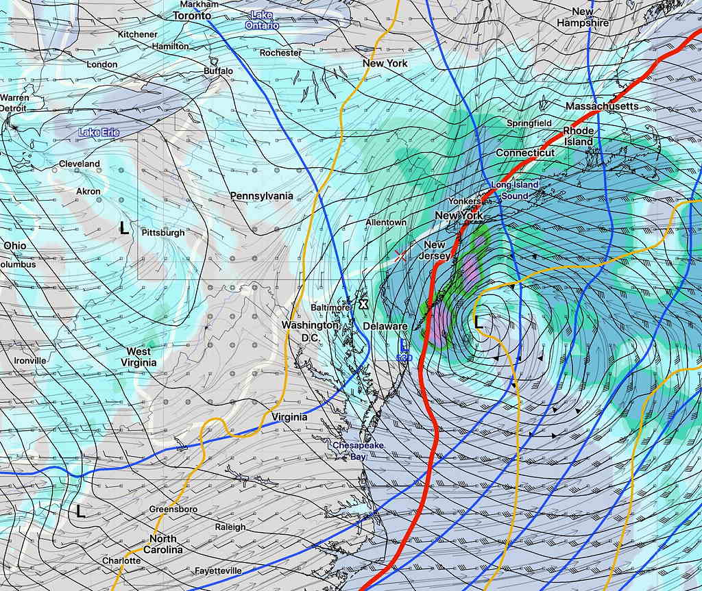
Updated Mon 07:40 PM— The general trend continues with the Saturday storm side-swiping us to our east.  Here’s the statistical version of the GFS  (GEFS) showing the range of positions of the low pressure system late Saturday afternoon.  Notice that there’s a difference in position but all the tracks/positions are off-shore:

GEFS pressure statistics: 90, 50, and 10 percentiles sea level  pressure.

Monday afternoon’s operational GFS has light snow making it into Philadelphia, but has just a coating.  Temperatures above freezing. Still too far in the future to make a meaningful forecast.

GFS Precipitation forecast 5PM Saturday

I heard on the news/weather tonight that “whether we get some snow depends on the track of the storm”.  Isn’t that the purpose of a forecast?  I can’t make these things up.


Updated Mon 08:10 AM— Last night’s models have not clarified the forecast for next weekend. The trend has been for the storm to be further off the coast, but the track and development is still considered to have above average uncertainty.


…from Sunday—

This afternoon’s clouds were expected and forecast, as an upper air disturbance rotates over us from the upper low pressure system associated with the rain that passed through yesterday.

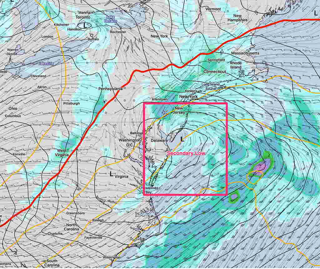
As mentioned in last Thursday’s post, some of the extended range models are suggesting the development of a coastal low this coming weekend.  (The extended range forecasters at the NWS have described the coming weekend’s weather as having higher than usual uncertainty. )

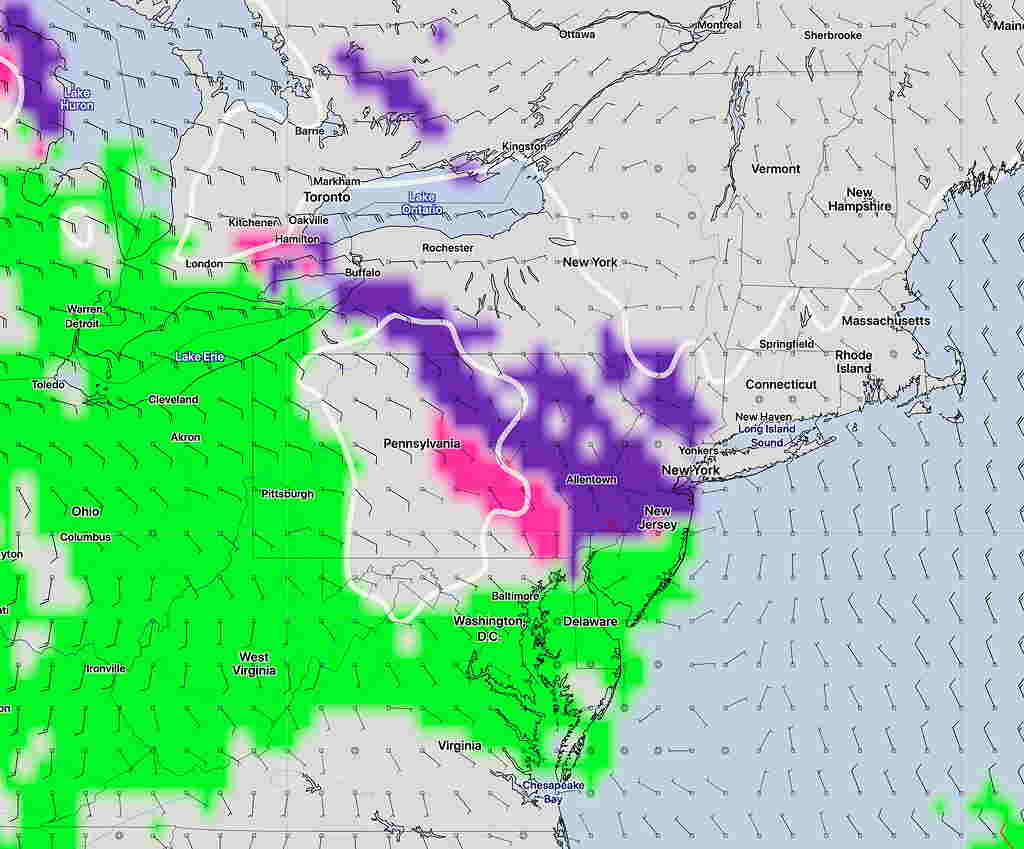
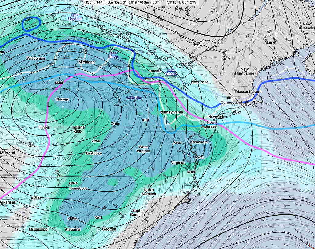
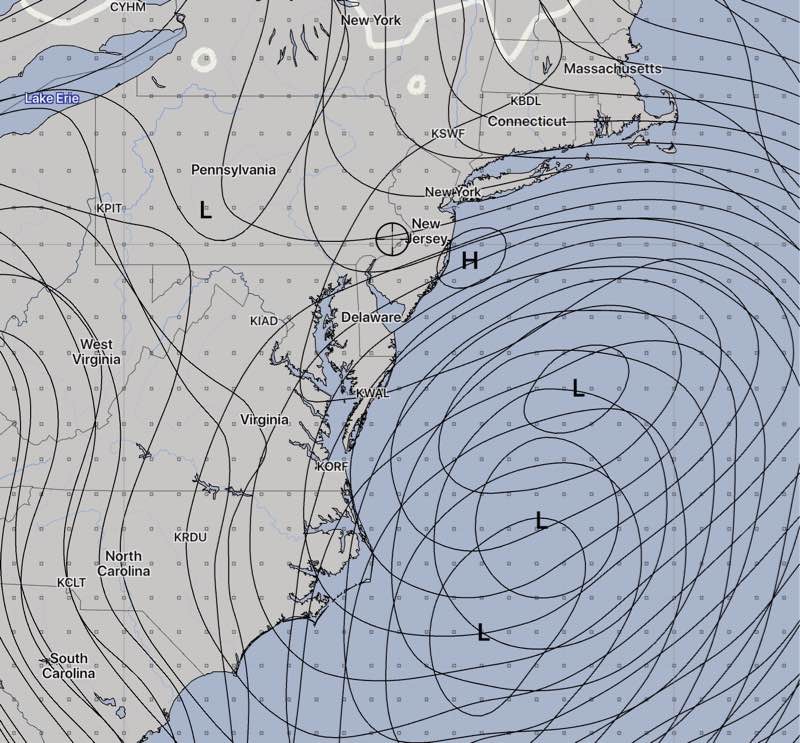
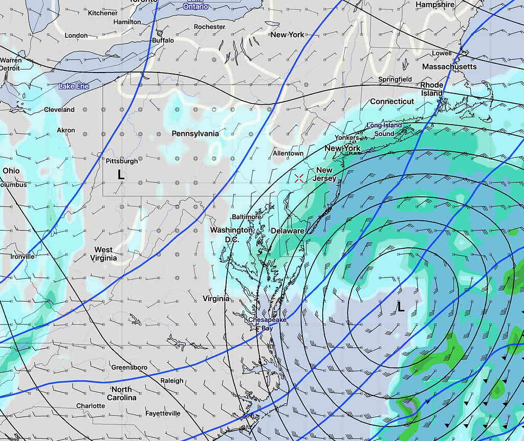
That said, this morning’s GFS, GEFS, CMC and ECMWF models are showing some sort of coastal low for us in an unclear time frame ranging from Saturday afternoon into Sunday.  The Canadian model shows the most developed snow storm for us and isn’t necessarily correct:

CMC forecast 1 AM Sunday morning

The GFS shows a low with less development and faster moving:

GFS Saturday 5 PM

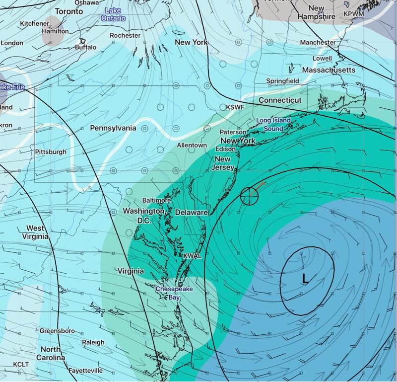
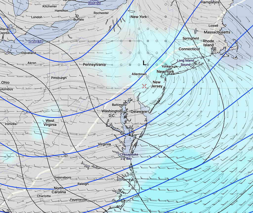
The latest GFS Ensemble forecast (GEFS) (statistical) shows a low that is least developed and slowest:

GEFS forecast Sunday 7 AM

I wouldn’t go out and replace your snow shovel just yet, but it’s something to keep an eye on.

Amazingly, this is the first time this entire winter season where anything resembling a coastal snow storm presented even as a possibility.

Last year, we had multiple ‘potential’ snow storms that all ‘evaporated’ as we got closer to the time of the actual event. This may be no different, especially with little model agreement.  Stay tuned.


WEATHER UPDATE

[su_note note_color=”#defcdc”]Sunday 12 PM Update: This morning’s models have become available. The trends—

Less QPF is expected today, rain amounts reduced from 1 inch to about 0.6 inches water.

For Monday, temps in the upper atmosphere support snow fallling during the afternoon, but surface temperatures remain too warm until evening.

The upper atmosphere cools after 2 AM tonight and any precip will fall as rain >> snow by afternoon.  The lower atmosphere temps are slow to chill down, complicating accumulation forecasts.

The NAM has a coating up to 1 inch (with the lower range more likely) by late Monday evening.  The GFS has surface temperatures too warm for any accumulation in PHL and the immediate suburbs. 

For snow, I tend to go with the NAM. 
[/su_note]

[su_note note_color=”#defcdc”]Sun 7:30  AM Update:  The 1 AM run of the GFS and NAM has moved the start of the precip to about 9 AM.  The latest HRRR depicts the freezing rain  further north and west —

HRRR PTYPE forecast for 9 AM Sunday

As I said yesterday, with the precipitation onset being revised each model run suggests that the models are having difficulty with this storm’s forecast. 

That said, my rule of thumb — when the models are having trouble with the very short term forecast, it puts into question their forecast for the following day. 

The models are still predicting a mix of rain and snow during the day and evening Monday, significantly more snow to areas north of Doylestown.  Last night’s ECMWF is all on-board with that forecast.  Can we really trust it with Monday’s forecast?   Stay tuned.

[/su_note]

…from last night—

Earlier this week, I described this weekend’s weather as “interesting” and indeed it is a complex scenario involving a secondary coastal low pressure system and an upper atmospheric low that will interact in complex ways. See my previous discussions about the systems involved, as the general scenario appears to be playing out as predicted.  Here are the latest model trends —

Freezing rain and sleet begins 5-7AM from the city just north and west, and changes to all rain from 9 AM to noon. The city proper, south and east will have mostly rain. Areas north and west will have a prolonged period of sleet and freezing rain.  The graphic below is the latest NAM model forecast of PTYPE.

NAM forecast for 10 AM Sunday. Green rain, red freezing rain, magenta sleet. White line is surface freezing temp

The other models are in general agreement.

After the changeover, rain heavy at times is expected. QPF values about 1 inch water.

Sunday night, cold air filters in in the upper atmosphere.

For Monday —An upper low trailing the surface low will bring additional precipitation on Monday. A changeover to snow and snow showers is expected during the day, however for the immediate PHL area and adjacent suburbs, surface temperatures remain above freezing until late afternoon, so accumulation will be highly limited here. Currently, the models are showing a coating to an inch by the time it ends late Monday night, with considerably more in far northwest counties.

There remains uncertainty about this Monday’s snow. Stay tuned.


INTERESTING WEATHER FOR THANKSGIVING WEEKEND

[su_note note_color=”#defcdc”]Tues PM Update:  The latest models forecasts are all very different, making it impossible to make a definitive forecast at this time for the time period late Saturday into Monday.

The only trend supported by the models is that start of precipitation has been pushed back into Saturday evening, instead of Saturday afternoon.

The general trend is for a secondary coastal low to form.

The GFS puts the low to our south, allowing cold air to move in late Sunday night.    It’s still looking like predominantly rain, except for the start and the end where snow may fall. 

The GFS has the storm lingering on the coast through Monday, as it waits for an upper low to catch up to it and become “vertically stacked”.

With so many different model forecasts, we’ll need to wait for things to clarify. [/su_note]

[su_note note_color=”#defcdc”]Tues AM Update: The storm forecast for the Thanksgiving weekend continues to evolve. The GFS is faster and brings precip (as wet snow) in late Saturday afternoon.

The ECMWF (European)  is slower and has the precip starting late Saturday night and continues into Monday.  It remains mostly rain for us before ending as light snow. 

The general scenario is    wet snow—> rain—> light snow     before ending.

Canadian CMC forecast 4PM Sunday showing coastal secondary low  formation.  (The wavy red line is the 500-1000mb “thickness” line which is often (but not always) the rain-snow line.)

Secondary coastal low pressure development is again in the picture which will affect how much snow falls towards the end of the storm and how long it lingers into Monday.  [/su_note]

…from yesterday—

A stormy weekend looking likely…

As mentioned over the past week or so, an outbreak of winter cold air will affect our area the first week in December.  The journey to this cold dip in the jet stream promises to bring an “interesting” weather event for a large area of the country including our area.

Let me cut to the chase— most of our immediate region will have rain as the predominant precipitation type (PTYPE).  That said, a number of thermal changes will occur during a rather prolonged low pressure passage.

Originally, the low pressure system was expected to affect us on Sunday. The timing has changed— precipitation will arrive on Saturday afternoon.  Thermal profiles are suggesting a possibility of wet snow at the start late Saturday afternoon or evening.

Current GFS Forecast for Saturday 4PM- Precipitation Type (green – rain, purple – snow, pink – ice)  (I tend not to rely too much on the built-in model PTYPE forecasts)


Below is the latest GFS Ensemble Forecast for 1 AM Sunday—

GFS Ensemble forecast 1 AM Sunday showing critical snow temperatures in our region (Lavender, blue,  light blue, white lines)  The model shows much of our area will be rain by 1 AM.

This precip will change to rain overnight and continue into Sunday.

As it stands now, much of Sunday will have heavy rainA changeover to light snow or flurries is possible towards the end of the storm Sunday evening.

As always, there are differences in the models.  The European ECMWF has a bit more snow for us Saturday late afternoon and Saturday night before a changeover to rain. The Canadian CMC  is a bit warmer.

The forecast for this weekend has changed considerably over the past day.   I expect more changes.   Stay tuned.