Category Archives: Weather Updates

FORECAST UPDATE

As mentioned in a previous forecast, with an upper closed low, the models rarely accurately predict the placement of the heavy rains and such was the case yesterday.  In fact, all of the models over-predicted rainfall, including the EMCWF (European).    Most areas in PHL and immediate surrounding areas only had 0.75 to 1 inch of rain.  The heaviest rain was in Maryland and near Baltimore.

(When it snows, everyone knows when the forecast QPF isn’t correct; when it rains, fewer people realize it.)

For today, Sunday, the NAM has some hazy sunshine breaking out by  morning or early afternoon. But it also shows high instability in the early afternoon with showers as early as 2 PM. The chance of showers continues thorough the evening.   These will be random and scattered.

The GFS LAMPS has increased chance of showers and thundershowers in the late afternoon.  The experimental NBM (National Blend of Models) has a high chance of showers and some embedded thundershowers during  late afternoon (4 PM) and evening, as does the EMCWF.

So, not a washout, but unsettled, with showers especially likely after 4 PM into the evening.

FORECAST UPDATE

Last night, I took a quick look at the models and saw that the forecast for Sunday had completely changed from 24 hours earlier.  I  updated the original post.

Sunday was originally forecast to be totally dry by several models.  Last night’s NAM showed an upper air disturbance moving through from the northwest early.

Today, things have changed further and this area of showers and thunderstorms is just entering our area at 10 AM. Showers move through and showers end by 2-3 PM.  Hazy sunshine with some clouds, warm and humid after the showers move through.

The models got this one wrong.

This morning’s latest NAM and GFS models got this forecast wrong.  Even as the snow is falling, both predicted a QPF of less than 0.10 inches water!  Hardly accounts for the snowfall.

Regarding the short range models, the NAM based HRRR (hourly forecast) also blew this one.  The GFS LAMPS forecasts (also hourly) shows snow likely until 2- 3 PM, although I find the GFS LAMPS is often wrong about such things.

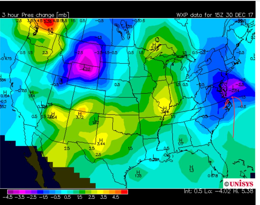
Forgetting about the models, using old forecasting techniques, pressures are dropping along the coastline, showing the development of a coastal low.  (See graphic below.)  Not sure if my trough explanation earlier was correct.

3 hour pressure falls.

So a much larger storm than forecast.  3-4 inches in some areas seems likely, although my guess is as good as yours.  Without some reliable numbers, it’s all guess work.

It does look like it’s ending in the western suburbs, based on current radar.

I’m wondering what the media forecast people are going to say about this one?  Usually, they just do their thing, as though the  coating to 2 inches everyone forecast was nearly correct.