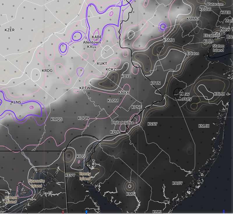
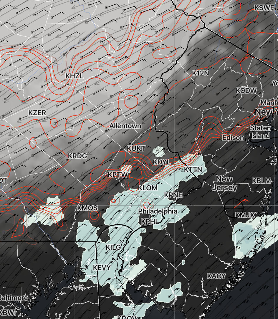
Updated Sun 8:35 AM — The latest HREF forecast for clouds—
Sunday morning (06z) HREF showing percentage clouds (dark/grey) and cloud cover spread (white and pink contours) at 2 PM. Greatest uncertainty remains over the Philadelphia area with clearing northwest of Pottstown (KPTW). No rain west of the Delaware river, although it will be close by. An edge or boundary area forecast resulting in high uncertainty. (Click on image for larger view)
Updated Sun 7:25 AM — It’s raining this morning. I was unclear about my clearing forecasts. My forecasts for clearing were to start late morning to 2PM.
Updated Sat 11:03 PM — Tonight’s HiRESW follows the NAM-NEST with a forecast of sun breaking out as early as late morning.
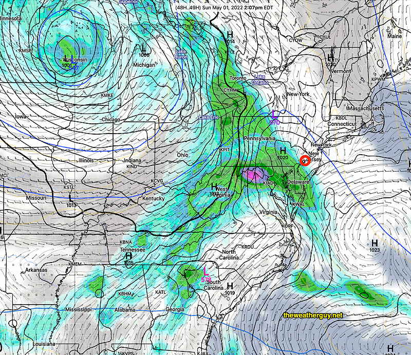
Update Sat @ 10:05 PM —A low confidence forecast for Sunday; the immediate Philadelphia area is an “edge or boundary” condition for the weather model’s cloud and precip forecasts. The individual model’s resolution and forecast biases are also in play.
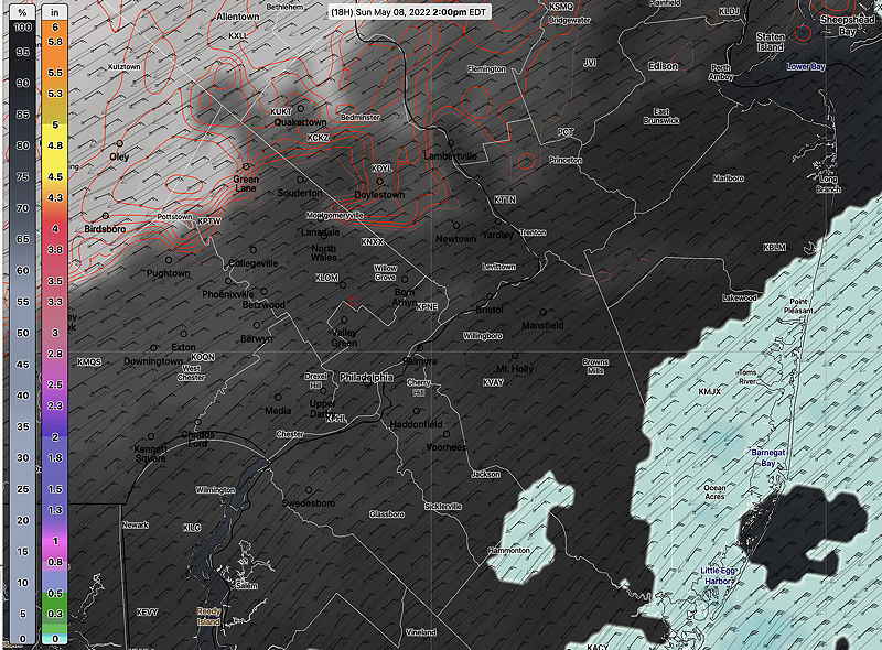
The latest NBM model (Model Blend) captures this quite nicely regarding precip chances and cloud cover, with conditions quite different far northwest (Green Lane) and Jersey Shore. In between is Philadelphia—
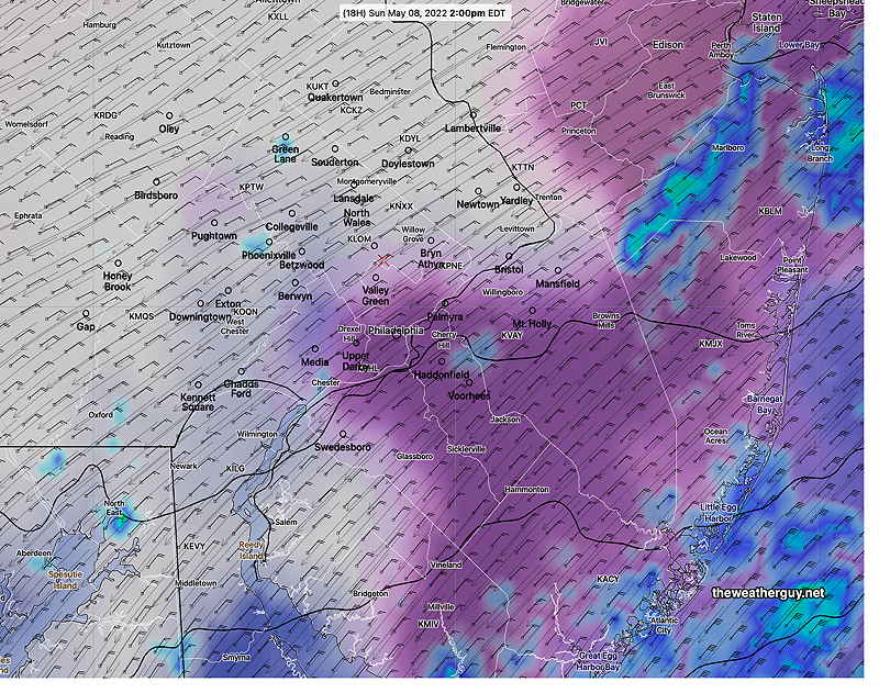
NBM Probability of 0.01″ Rain for 2 PM. The edge condition is right over Philadelphia. Basically, the NBM has a dry forecast for Philadelphia and western suburbs. (Anything more than 18% chance in a 1 hour period is a fair chance of rain I have the color scale set as such.) Rain is likely at the Jersey shore, and unlikely northwest of the city. (Click on image for a larger view.)NBM % total cloud cover and rain accumulation 2 PM Sunday. The Red contour lines are areas of higher uncertainty cloud cover; it may be less or more cloudy Basically, the NBM is showing light rain/drizzle at the shore and a fair amount of cloudiness over the immediate PHL area. Areas northwest of Green Lane and even Doylestown may see some sunny breaks and/or bright skies. (Click on image for a larger view.)
The latest NAM just available has some showers in areas where the NBM is dry. The earlier HREF model was essentially dry for Philadelphia. The Canadian RGEM had showers and the ECMWF was dry, but had showers move in from the east after 4 PM. So a very tough forecast situation.
Based on the latest NAM-NEST just available, I am leaning towards dry conditions, periods of clouds and breaks of sun from Philadelphia and north and west.
NAM-NEST Clouds and simulated Radar 2 PM Sunday Areas northwest have considerable sunshine
Update Sat @ 8:29 AM —
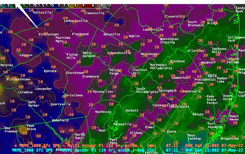
Latest MRMS rainfall totals (24 hours beginning 7 AM) Numbers are millimeters (25.4 mm = 1″) North, northwest and western suburbs have received 1-1.8 inches of rain over the past 24 hours. (Click on image for a larger view.)
Update Sat @ 7:14 AM — Last night’s models continue the uncertainty around lingering showers and cloud cover for Sunday. The NBM shows some clearing and dry conditions just north and west of Blue Bell (KLOM) —
Today’s 07z NBM showing showers in Philadelphia at 11 AM, with some thin clouds/sunshine towards Allentown. A 25 mile difference in model precision leads to a very different forecast for Sunday. Additionally, the latest GFS and HRRR show additional showers rotating in around a coastal low in the late afternoon Sunday (4 PM and later) in approximately the same areas.
Update Fri @ 11:20 PM — Tonight’s HIRESW actually has sunshine after noon time northwest of the city on Sunday, then clearing in Philadelphia during the afternoon!
Update Fri @ 8:28 PM — Little change in the forecast posted below. The heaviest rain will occur this evening and overnight into early Saturday. Total rainfall in the 2-2.5 inch range, with 2 inches of it occurring before 11 AM Saturday.
The notable feature for Saturday will be windy conditions. Following morning steadier rain, light intermittent rain expected throughout the remainder of the day.
Little/no rain expected Sunday, but cloudy conditions will persist for most of the day. Reverting to original Sunday forecast below: Little/no rain Sunday morning, with some bright spots, possibly some sunny breaks early afternoon before spotty precipitation moves back in late afternoon/evening.
I’ve updated the Saturday and Sunday high temps below with the latest NBM model run.
Previously Posted Fri 12:07 PM —
A highly amplified jet stream level trough will spawn a closed low in the mid level of the atmosphere and low pressure at the surface. Clouds, wind and rain for Friday through early Sunday.
Current position (Friday AM) of upper trough, as revealed by satellite mid level water vapor imagery—
Water Vapor image Friday at 9 AM revealing deep upper level trough in the center of the US. This will move eastward and be over us by Saturday night as shown in the GEFS model forecast immediately below. (Click on image for a larger view.)
Forecast position of upper trough Saturday 9 PM—
GEFS showing 250 mb winds (jet level ~33,000 feet) for Saturday at 9 PM. A highly amplified trough with low pressure over the eastern US. (Click on image for a larger view.)
Saturday
Rain is expected much of the day, although it will lighten and become a bit more spotty late in the day. Very WINDY and gusty; a strong northeasterly wind will keep high temps near 51.6º± 2.1º (NBM model, Blue Bell) (Average seasonal high is 71º!)
There’s remains uncertainty regarding the timing of the rain ending. The latest NBM and ECMWF have clouds, but no rain here on Sunday. The higher resolution models (HIRESW-FVS, NAM, NAM-NEST continue with light showers into the early afternoon, then mostly cloudy, with some bright spots, possibly some sunny breaks. High temp near 53.0º± 3.9º (High temperature spread = high uncertainty) NBM model, Blue Bell)
Some additional scattered showers possibly spring up Sunday evening.
Sun 7:33 PM — Forecast Review — Overall a beautiful day and nicer weather than forecast. The clouds moved in later than had been predicted. The rain made it a bit further into Philadelphia than forecast this afternoon, but did diminish in intensity as forecast. Yesterday’s ICON and Canadian GEM did better than the GFS with forecasting the late arrival of the showers.
More showers expected later this evening and after midnight.
Update Sun @ 8:28 AM — Despite the early sunshine, clouds are expected to move in by late morning. Last night’s late models (06z) continue with the forecast of showers dissipating as they move into Philadelphia this afternoon.
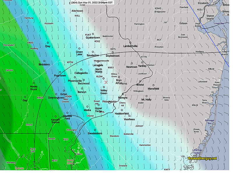
Most of the eastern area will be dry today (until this evening). Here’s last night’s high resolution HIRESW model forecast showing the eastern extent of the showers this afternoon at 4 PM; they aren’t expected to move much more eastward this afternoon—
HIRESW-ARW2P5 model forecast showing rain/radar and clouds (black) at 4 PM. This is the furthest eastward extent of the rain this afternoon. More showers after sunset throughout the area. (Click on image for a larger view.)
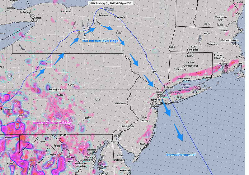
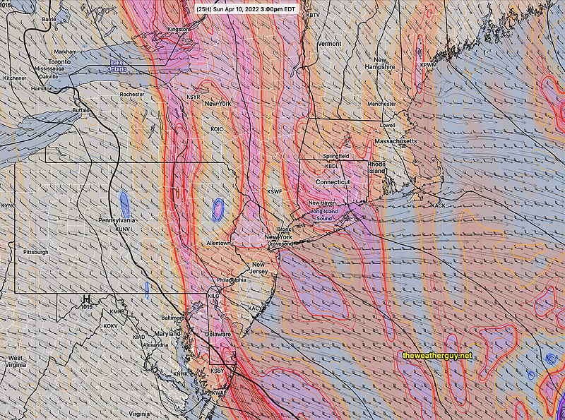
Why does the rain dissipate? The reason is a sharp mid level (500 mb) ridge that doesn’t allow vertical upward motion eastward—
HREF 06z showing the 500 mb (~18000 feet level) ridge (thin blue line) and upper wind flow (blue arrows). Due to this sharp upper ridge, the upward vertical motion (violet-pink= upward vertical velocity) is possible only on the western side of the ridge line.
Update Sat @ 10:40 PM — Tonight’s models have the rain in far western suburbs Sunday afternoons, but struggling to move into the city during the afternoon as it hits a sharp mid-levelupper air ridge. Much of the eastern area remains dry during the day. Still a lower confidence forecast.
Update Sat @ 9:15 AM — There’s still some uncertainty about the onset of showers Sunday. The GFS, GEFS, SREF and ECMWF have showers moving in from the west by 12-2 PM. The Canadian RGEM and ICON have a later onset, towards evening. I’m leaning towards the GFS group—
Saturday’s 06z GEFS shows showers moving in by 12-2 PM (Click on image for a larger view.)
Update Fri 10:13 PM— Tonight’s models suggest an even earlier start with the showers on Sunday, possibly late morning to noontime. The NBM still holds the showers off until evening. So forecast uncertainty remains for Sunday.
The forecast for the weekend has clarified since posting yesterday’s outlook. High pressure will be with us for Saturday. The timing of an approaching warm front on Sunday will occur earlier than many models had been forecasting— the warm front will bring some showers as early as Sunday afternoon. (Most models have joined the GFS and ICON with the earlier showers.)
Saturday
High pressure will influence our weather on Saturday. It will still be somewhat windy mid-day. Highs 65º ± 1.0º NBM model, Blue Bell
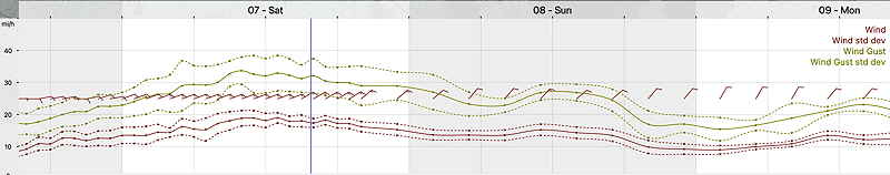
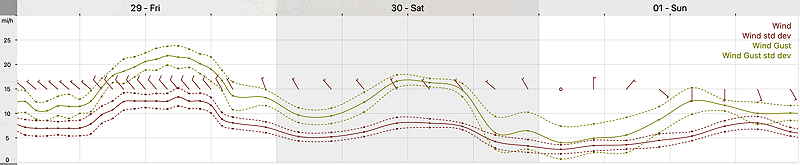
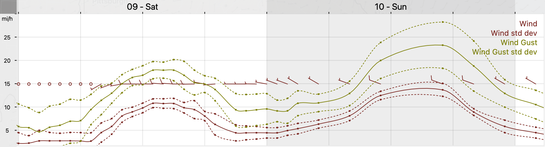
NBM wind /wind gust meteogram for Blue Bell, PA- Friday through Sunday (Click on image for a larger view.)
Sunday
High pressure moves off as a warm front associated with a deep low in the Great Lakes region approaches. Today’s models have joined yesterday’s GFS and ICON models—w showers move as early as 2- 4 PM, especially west and southwest of the immediate PHL area. Highs 66.3º ± 3.0º NBM, Blue Bell (large spread due to uncertainty in cloud cover.)
Thursdays’s 12z GFS shows clouds and showers moving in about 4 PM Sunday as a warm front approaches. (Click on image for a larger view.)Friday’s 18z GFS shows rain on our doorstep as early as 1- 2 PM (Click on image for a larger view.)
Update Sat @ 9:56 PM — For Sunday, today’s models show a significant amount of mid-level cloudiness developing towards noon Sunday and dissipating mid to late afternoon. There will still be plenty of breaks sunshine. It will be windy and chilly; the high temperature of 51° will be reached late in the day.
There’s even a chance of more sprinkles in the late afternoon, especially north and west of our area.
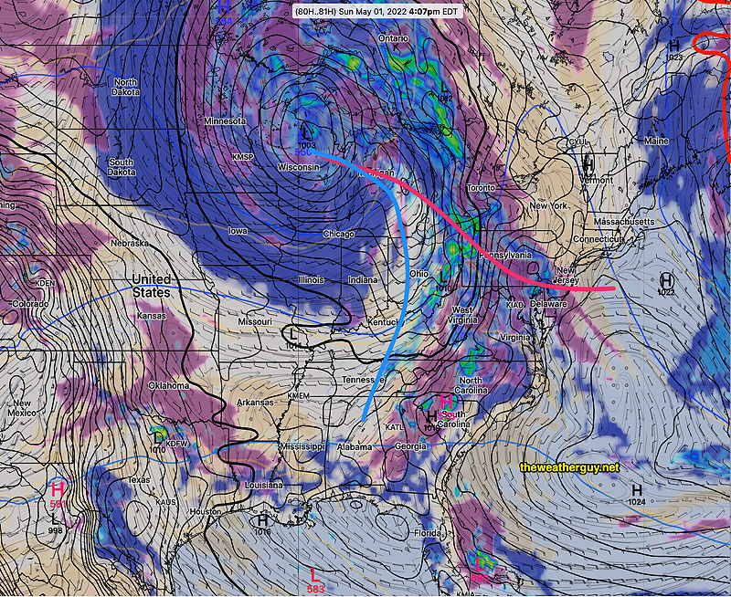
This cloudiness is the result of continued instability and a stream of upper air disturbances passing over us, rotating around the departing upper air low.
GFS 500 mb vorticity at 3 PM Sunday. The western back edge rotates through our area about 4-5 PM, allowing clearing (Click on image for a larger view.)
A deep upper trough over our area will bring unsettled conditions on Saturday and cooler than seasonal average temperatures. The trough gradually moves away on Sunday, but still affects us. A upper ridge with milder temperatures moves in next week.
Saturday
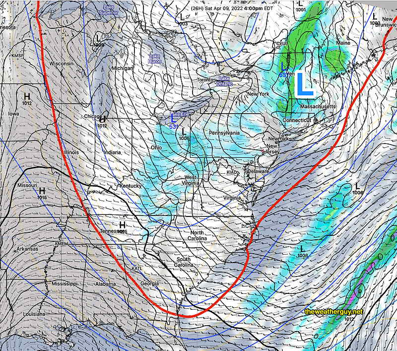
The upper trough will result in considerable instability cloudiness and showers. Showers will be widely scattered, more numerous early morning, then breaking out, scattered again, in the afternoon. There may be significant sun late morning before instability clouds develop.
Today’s 18z NAM forecast for 4 PM Saturday. A low pressure system over Vermont and an upper low over Lake Erie with a deep trough, indicated by the red 540 thickness line. Showers and clouds over our area. (Click on image for a larger view.)
A mix of clouds with breaks of sun, not very different than last Saturday. We’ll have widely scattered showers, especially in the afternoon. The cold air aloft may again result in some frozen form precipitation (graupel), much like last weekend. WINDY at times. High temperature 53.3º ± 2.1º NBM model, Blue Bell. (Average seasonal highs are 60-61º)
Sunday
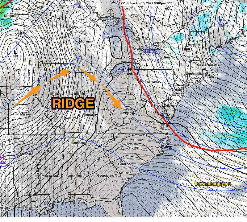
The trough begins to lift, but the cold air will still be over our area.
Today’s 18z NAM forecast for Sunday at 5 PM. Surface low still over New England, upper trough (red line) moving up and away. Some clouds but dry weather here. Upper ridge poised to move in from the west for next week. (Click on image for a larger view.)
Mostly sunny skies with still cool temperatures. Gusty winds at times. High temp 50.3º ± 2.0º NBM model, Blue Bell.
A ridge moves in next week with warmer temperatures.