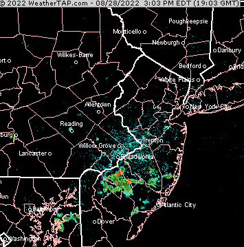
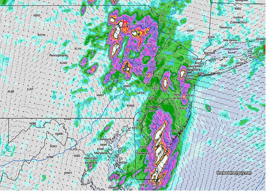
Forecast Review— 08/28 @ 5:01 PM — Some showers did develop about 2-4 PM today as forecast but most areas just saw clouds—
NEXRAD radar loop this afternoon. Some showers did actually develop, but most areas saw only increased cloudiness
Note that NOAA model data is still delayed or partially unavailable due server issues as described over recent days.
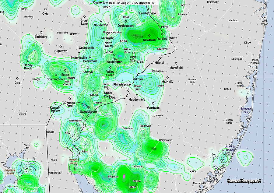
Update Sun 08/28 @ 11:31 AM — There were some showers in NJ yesterday and this morning’s models continue to forecast some pop-up showers moving in from the east by 4 PM today, Sunday —
Today’s 12zHREF forecast model shows considerable showers at 4 PM today. Many models have been over-forecasting rain over the past day and I’m not all that confident that we’ll see so many areas with showers today. (Click on image for a larger view.)
Updated Sun 8/28 1:30 AM —Several of tonight’s models show showers and thunderstorms developing over the immediate Philadelphia area Sunday afternoon into Sunday evening.
Update Sat 08/27 @ 9:45 AM —Last night’s GFS continues with the forecast of an easterly flow causing some very widely scattered showers at the Jersey Shore later today with clouds moving in from the east towards Philadelphia during the latter part of the afternoon (4-7 PM). Some light showers may also just make it into Philadelphia from the east.
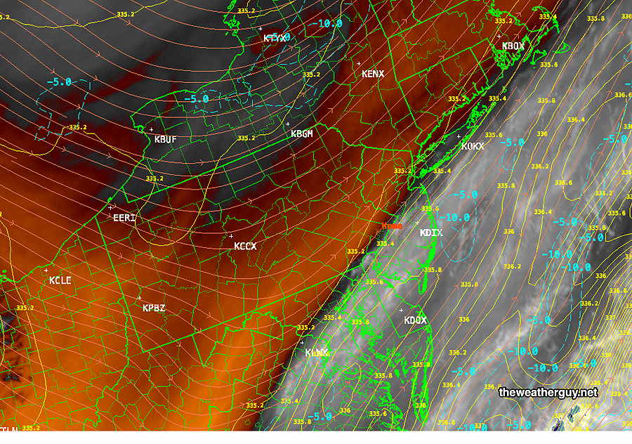
The likely western boundary for any showers is visible on the current water vapor imagery, running right through Philadelphia—
Water Vapor Satellite Image shows dry, warm air west of Philadelphia (orange) with colder higher level water vapor east of Philadelphia. Blue contours show beginning moisture convergence offshore, expected to move westward Orange contours are wind contours at jet stream level -250 mb (RAP model) (Click on image for a larger view.)
Despite forecasts of 90º on radio and TV, the NBM has only been showing upper 80s for most of the area.
Note that NOAA model data is still delayed or unavailable due server issues as described yesterday.
Previously Posted Fri 9:46 PM —
A weak front, expected to move through Friday afternoon, has slowed and will stall south of the area. High pressure tries to build in for the weekend.
Latest ECMWF (18z) shows high pressure over New England by Saturday afternoon. An easterly flow may bring some showers to South Jersey.
Ordinarily, this would mean fair weather, but this high will move to our northeast and an easterly flow around the high may result in low level moisture convergence with some clouds and some showers possible during the afternoons, especially in NJ on Saturday and from Philadelphia east on Sunday.
Saturday
Mostly sunny with some periods of clouds mid to late afternoon. A few scattered showers, mostly in South Jersey. High 87.2° sd 1.6° NBM model, Blue Bell.
Previously Posted Fri 9:46 PM —
Sunday
Partly sunny, again with periods of clouds and a few widely scattered showers from Philadelphia and east. High 87.3° sd 3.2° (higher than average spread) NBM model, Blue Bell.
Update Sun 08/21 @ 8:41 PM — We had some break out showers Sunday afternoon that went through Citizen’s Bank Park. These had very limited coverage as they moved northward.
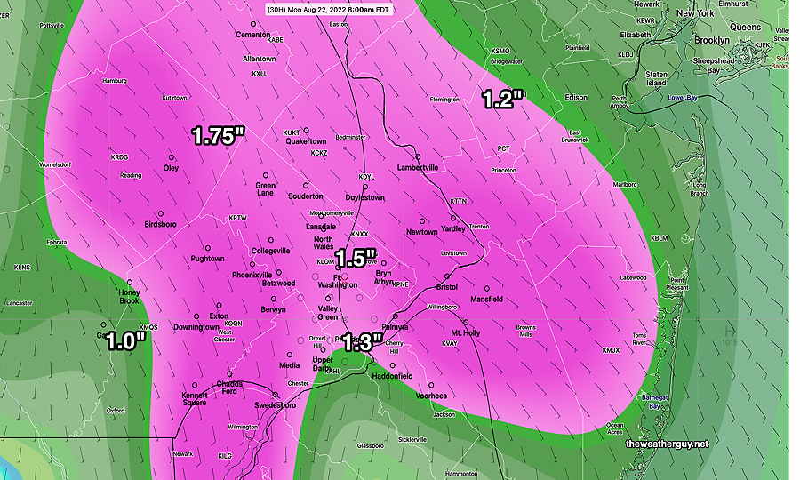
So…Are we really going to get about an inch of rain by Monday evening?
The latest RAP and GFS were in the 0.8- 1.0 inch range.
The NAM-NEST had the heavy rain splitting into two areas: far north of Philadelphia and far south of Philadelphia. The immediate PHL area was just getting about 0.4 inches—
18z NAM-NEST shows the heaviest rain far north and far south. It’s an outlier, but not to be ignored. It’s sorta what I expect during a drought where this sort precipitation miss has occurred several times before in recent months. (Click on image for a larger view.)
I’m going to stick with the current “about 0.75-1.25 inches” forecast.
And I’m going to avoid my usual temptation to update my forecast later with tonight’s models…the rain event is too close and errors from model spin up time may move the forecast in the wrong direction.
Model spin up is the time a model takes to combine initial conditions at the start of the model into a state of thermal and mass-velocity equilibrium.
Due to spin up time, the first few forecast hours of a new model run may be less accurate.
Models are very complex mathematical constructs that incorporate starting conditions and observations, in a process called “initialization”, to accurately simulate and blend (and not conflict) with its past simulation so that it maximally captures ‘reality’ at the start. Short range models can take 3 or more hours to spin-up. The new models being developed by NOAA have a built in ‘cold start’, followed by an intentional 6 hour spin up!
Most current models do not ‘cold start’ but still have a spin up time to ‘mesh’ past runs into equilibrium with new observations. The 00z models from last night all have new upper air measurements that need to blend into equilibrium with the previous run.
Thus, spin up time is needed. If heavy rain is falling in our area at the start of initialization, it can throw off the first few hours of the precipitation forecasts of the new model run until equilibrium is reached.
Am I still skeptical about this amount of rain during a mini-drought? Yes. (Maybe the NAM-NEST shouldn’t be ignored?)
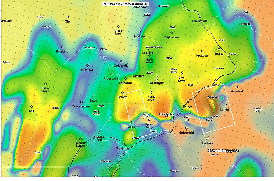
Update Sun 08/21 @ 9:40 AM — The latest ECMWF accumulated rain forecast—
The latest ECMWF rain forecast by end of day Monday. The ECMWF is on the high end of the forecast spectrum. Despite the drought conditions, the ECMWF has been consistent about this expected rainfall. I’m skeptical, but the models are the best tools we have. (Click on image for a larger view.)
The latest HRRR (12z) just available shows the rain (and thunderstorms) moving in after midnight tonight (Sunday). The HRRR is predicting the possibility of some strong thunderstorms about 8 AM Monday morning.
HRRR Simulated Radar with CAPE and Helicity overlay. Boxed areas show elevated helicity and vertical shear with the possibility of strong to severe thunderstorms. (Click on image for a larger view.)
Updated Sun 8/21 9:03 AM —I expect the sun to break out later this morning. Rain waits for the evening hours, most likely after 8 PM. The GFS and NBM still crank out rainfall amounts in the 0.7-1 inch range for much of the area. The HRRR has reduced the rainfall amount to less than 0.5 inches.
Updated Sat 8/20 10:19 PM — Despite several of last night’s models having forecast widely scattered afternoon showers to our immediate north, none were to be found today except in far northeastern Pennsylvania. While writing this update, today’s 18z (2pm EDT) ECMWF became available. (There’s a 7 hour delay for free ECMWF data downloads.) Incredibly, this afternoon’s ECMWF was still forecasting the afternoon showers that never materialized.
Sunday— Periods of sun and periods of clouds. High temp 87.5° sd 1.5°. A few scattered showers as early as 6 PM, but the main area of rain moves in about 10-11 PM.
The models are cranking out anywhere from 0.75” to 1.25” of rain through Monday.
Currently, a rainy day is forecast for Monday with up to one inch of rain forecast. However, we’re in a dry spell that is tough to break. Soil moisture is extremely low resulting in negative feedback. Additionally, we’re in the uptick phase of a well-recognized but little talked about Hale 22 year Solar Cycle that is highly-correlated with drought conditions (but poorly understood). Do a Google Scholar search on “Solar Cycle and drought” for scientific journal articles on this subject.
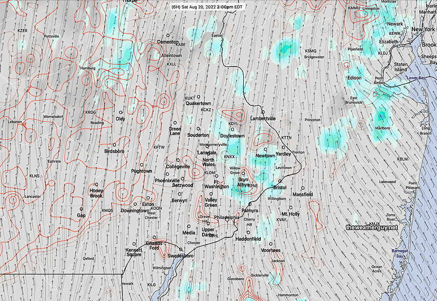
Update Sat 08/20 @ 9:32 AM — Last night’s models shows a warm front moving up to our north and west later this afternoon. This feature didn’t show on earlier models, but does show on today’s water vapor image.
WV image 9:30 AM with warm front (drawn). (Click on image for a larger view.)
The latest HRRR shows very little activity, but the ECMWF and NBM show light scattered showers possible.
Today’s 12z NBM at 2PM showing light scattered showers. (Click on image for a larger view.)
As for the onset time for showers on Sunday, there’s still a range of model forecasts, but most wait until evening.
Weather pattern transition
Previously Posted Fri 5:25 PM —
The delightful and low humidity weather pattern we’ve been in this past week will change over the weekend.
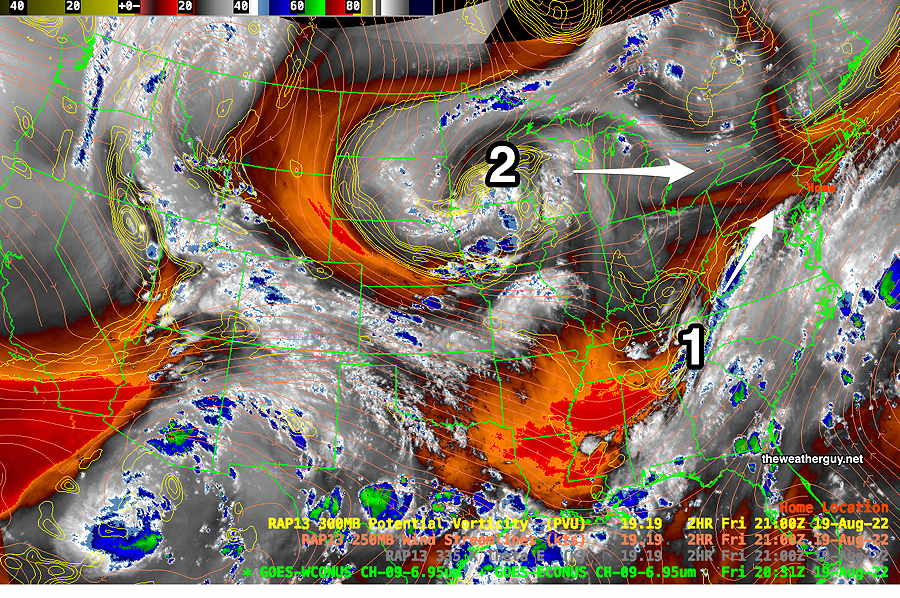
Increasingly warm and humid air will move in from the south. A disturbance to our southwest this evening (1) will bring some light showers before daybreak Saturday morning, mostly to far western suburbs.
WV image Friday afternoon shows main disturbance moving off Carolina coastline. However, an additional disturbance (1) along the Appalachians may bring some showers before daybreak to far western suburbs Saturday morning. For Sunday into Monday, the upper low (2) will move eastward [hopefully] bringing some much needed rain late Sunday through Monday. (Click on image for a larger view.)
Saturday
Following some very early morning cloudiness, especially far western suburbs, it will become partly to mostly sunny, very hot and more humid than recent days.
High temperature 90.1º ± 1.5º NBM model Blue Bell, PA
Sunday
The disturbance from the west (2 above) will move in. Sunny early, becoming increasingly cloudy in the afternoon. There is still uncertainty with the timing of any light showers, but there’s a strong signal (especially from the ECMWF and NAEFS) that some scattered shower activity may begin in the early afternoon instead of the evening. The majority of the models (and the NBM) hold off the showers until after 7 PM. More humid, but clouds will hold down the high temperatures.
High temperature 85.7º ± 2.4º NBM model Blue Bell, PA
Update Sat 08/13 @ 8:26 AM — We may be disappointed with the amount of rain that had been expected for Monday into Tuesday. The low pressure system and upper trough are forecast to set up in a position that would minimize precip in our area. The latest ECMWF captures it well—
ECMWF shows upper low with the rain mainly to our south, west and east; essentially the same pattern for the past two months. (Click on image for a larger view.)
Updated Fri 8/12 10:49 PM —It looks like we’ll have some cloudiness move in during the mid afternoon on Sunday, somewhat earlier than previously forecast.
Previously Posted Fri 5:46 PM —
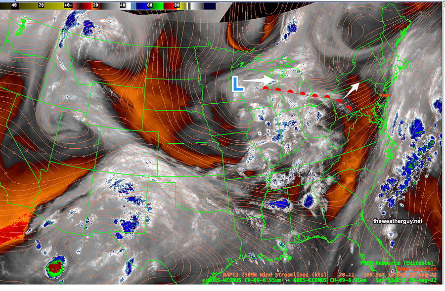
This weekend, we’ll be under the influence of a cool, low humidity high pressure system that has pushed the jet flow into a trough pattern. We haven’t seen a trough pattern here for many weeks—
GEFS (mode) 250 mb winds showing rather deep trough over the eastern US. (Click on image for a larger view.)
The forecast for this weekend will be relatively simple. Mostly fair skies and low humidity.
Following the weekend, the same upper trough will produce unsettled weather.
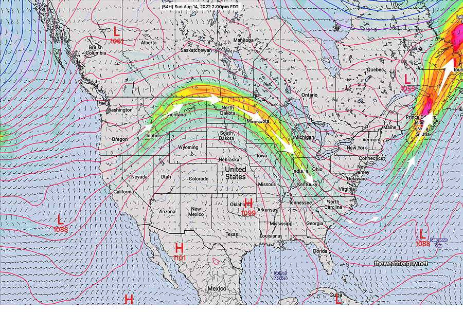
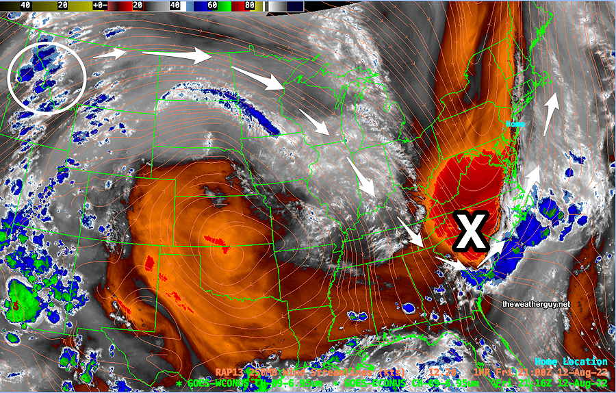
As shown in the current water vapor image below, an upper air disturbance in Idaho will move along the jet flow and develop into a surface low pressure system late Sunday evening through Monday and possibly lingering into Tuesday—
Current Water Vapor Image (Friday 5 PM) with RAP model jet wind contours shows upper air disturbance (blue areas in white circle) will move along the jet flow and spawn the development of a surface low pressure system (X) that may bring much needed rain Monday and possibly into Tuesday.
Saturday
Sunny and very pleasant. Breezy.
High temperature 81.3º ± 1.8º NBM model Blue Bell, PA
(Seasonal average high 84º Blue Bell, 85º Philadelphia)
Sunday
Continued sunny and pleasant. Light winds. Increasing cloudiness late afternoon and early evening.
High temperature 82.7º ± 2.5º NBM model Blue Bell, PA
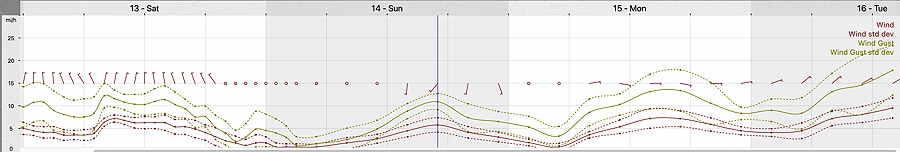
19z NBM Wind Meteogram for Blue Bell, PA (Click on image for a larger view.)