Posted Sunday 09/01/24 @ 9:35 AM — The forecast continues to have cloudy skies (perhaps with some bright spots at times) and not much rainfall as a front is stalled over our area and small disturbance will move up towards us—
Current satellite water vapor image with superimposed RAP model 500-1000 mb thickness lines (yellow), Mean Sea Level Pressure isobars (black contours) potential vorticity (fine violet contours) with superimposed MRMS RADAR. Stationary front over our area. (Click on image for a larger view.)
A few weak disturbances will move along the front with some light showers possible Sunday afternoon and again this evening as a secondary cold front is expected to move through late.
Increasing sunshine from northwest to southeast Monday. Cooler with lower humidity.
Unseasonably cool weather this week. Sunny with little chance of rainfall.
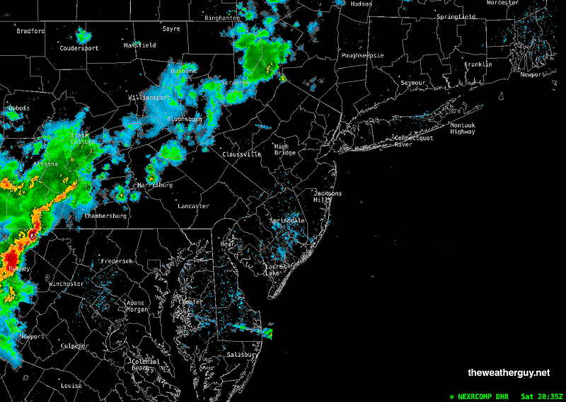
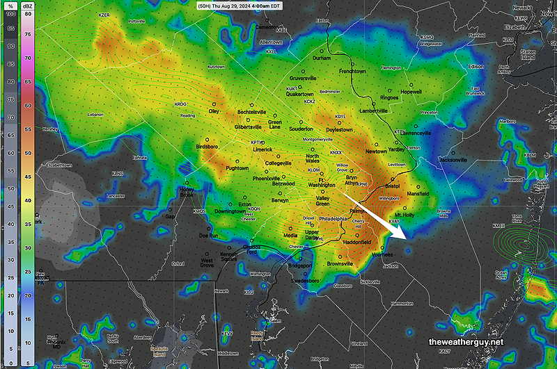
Sat 4:30 PM —Forecast Review — We had some sun and clouds, but the amount of sunshine was considerably less than forecast. As a result, high temperatures were lower than forecast, closer to 82º and dew points were only in the upper 60s instead of the low 70s. Current radar shows a line of storms and showers near Harrisburg, not forecast by the models.
Radar at 4:35 PM. The complex of storms near Hazelton is dissipateding as forecast. (Click on image for a larger view.)
So this weekend’s forecast is continuing with the lack of accuracy and low confidence that had been the situation of this past week.
Rain is forecast by the models to reach us about 11 PM and after midnight. It’s also expected to weaken considerably as it approaches, with heavier rain in northern Bucks county. There’s low confidence in this forecast, since the current situation isn’t being accurately modeled.
While the timing is uncertain, I do think there will be weakening of the storms as they approach our area.
Saturday Forecast Update
Posted Saturday 08/31/24 @ 8:24 AM — Last night’s 06z models show more sunshine for today than previously forecast in many, but not all, areas.
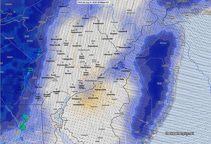
Here’s the latest RRFS cloud cover forecast for noon—
Experimental RRFS cloud- radar forecast for 12 PM Saturday. Blue=low clouds, maroon=mid-level clouds, tan = high cirrus clouds (Click on image for a larger view.)
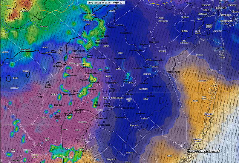
Regarding showers, the showers associated with the approaching cold front move in late from the northwest, about midnight tonight (Saturday).
Heaviest showers appear to skip over the Philadelphia area, keeping many areas in a rainfall deficit.
RRFS cloud-simulated radar forecast for midnight. Blue=low clouds, maroon=mid-level clouds, tan = high cirrus clouds (Click on image for a larger view.)
For Sunday, low clouds break for sunshine through high cloudiness by early afternoon. Cloudy at the shore. Some scattered instability showers develop after 3 PM throughout the area.
Originally Posted Fri 5:19 PM — A warm front will pass north or our area Friday night into Saturday. An approaching cold front will bring showers and storms Saturday night into Sunday morning. The front will slow on Sunday.
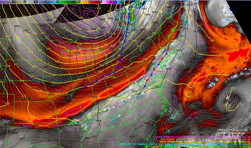
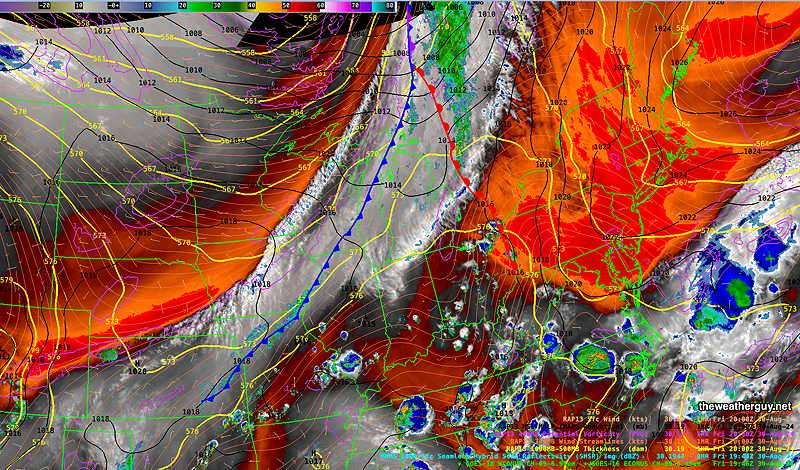
Here’s the current water vapor image showing these features—
Current (4 PM Friday) satellite water vapor image with superimposed RAP model 500-1000 mb thickness lines (yellow), Mean Sea Level Pressure isobars (black contours) potential vorticity (fine violet contours) with superimposed MRMS RADAR. (Click on image for a larger view.)
The front will slowly sag south as weak low pressure develops along the front, causing clouds and showers to linger through Sunday.
Saturday Forecast
Some areas will see sunshine in the morning, some areas west will have more clouds and some spotty sprinkles. Overall, very changeable skies in many areas. The Jersey shore looks to have a fair amount of sunshiine.
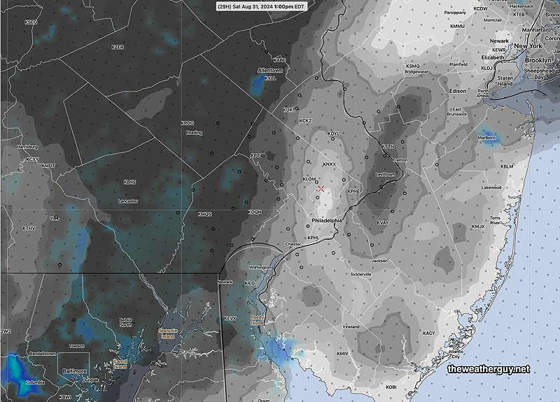
Here’s the RRFS cloud/radar forecast for 2 PM—
RRFS experimental Clouds with simulated radar at 1 PM Saturday. Darker is cloudier. (Click on image for a larger view.)
Humid with dew points in the low 70s.
NBM high temperatures: Blue Bell, PA 85º Philadelphia, PA 86º Above Average Uncertainty (based on standard deviation): ± 2.3º
Sunday Forecast
Cloudy with lingering showers in the morning. Brighter skies at the west of the city in the afternoon with clouds and possible showers lingering in NJ and at the shore.
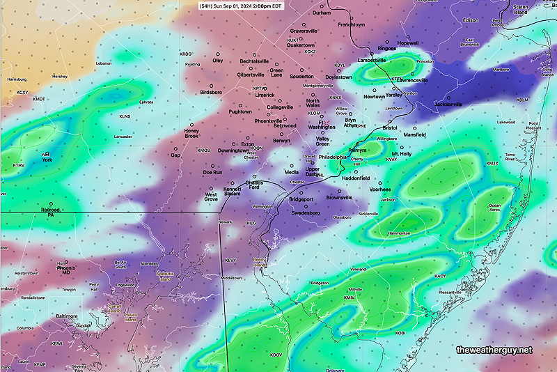
Here’s the latest experimental REFS depicting showers at 2 PM Sunday—
REFS forecast for 2 PM Sunday. (Click on image for a larger view.)
Increasingly breezy. Humid with dew points in the low 70s.
NBM high temperatures: Blue Bell, PA 85º Philadelphia, PA 86º Average Uncertainty (based on standard deviation): ± 1.8º
Monday Forecast
Sunny and breezy. Low humidity
NBM high temperatures: Blue Bell, PA 77º Philadelphia, PA 79º Low Uncertainty (based on standard deviation): ± 1.3º
Posted Thu, 08/29/24 @ 7:44 PM— Clouds moved back in Thursday afternoon and low level cloudiness is expected for much of Friday. Showers and storms in central PA this evening are again having trouble moving into the Philadelphia area intact.
The models (again with the exception of the ECMWF) have some light showers making into the immediate PHL area in the predawn hours Friday. Any rainfall here will be light.
Low clouds and even some drizzle is expected on Friday with an easterly wind providing the moisture. Some additional showers may pop up Friday afternoon due to moisture convergence.
Saturday is looking fairly cloudy, except at the shore. A cold front moves through with showers and storms Saturday night and some showers will linger into Sunday, especially in NJ.
Sunshine for Monday, but some high clouds may linger at the shore due to a low pressure system developing on the front to our south.
The model forecasts haven’t been too stellar this week. My guess is that changes in the Labor Day Weekend Forecast are likely.
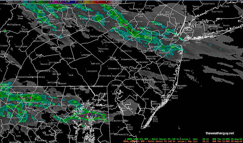
Thu 8:10 AM —Forecast Review — The areas of showers and thundershowers last night went to our north and to our south, as shown by this morning’s MRMS 24 hour precip summary—
MRMS rain-gauge measured rainfall combined with rain-gauge calibrated and interpolated radar-based summary of ACTUAL RAINFALL RECEIVED. Color shading is in inches. Line contour numbers are in mm. (25.4 mm= 1 inch) (Click on image for a larger view.)
The expected complex of storms expected to move just near Philadelphia at 3 AM didn’t materialize. Numerous models got this wrong, with the notable exception of the ECMWF.
Many parts of our area haven’t had very much rainfall in weeks. The forecast for tonight (Thursday night) into Friday is for significant rainfall in the Delaware Valley and the ECMWF is currently on board with this forecast.
Thunderstorm Possibility
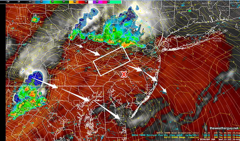
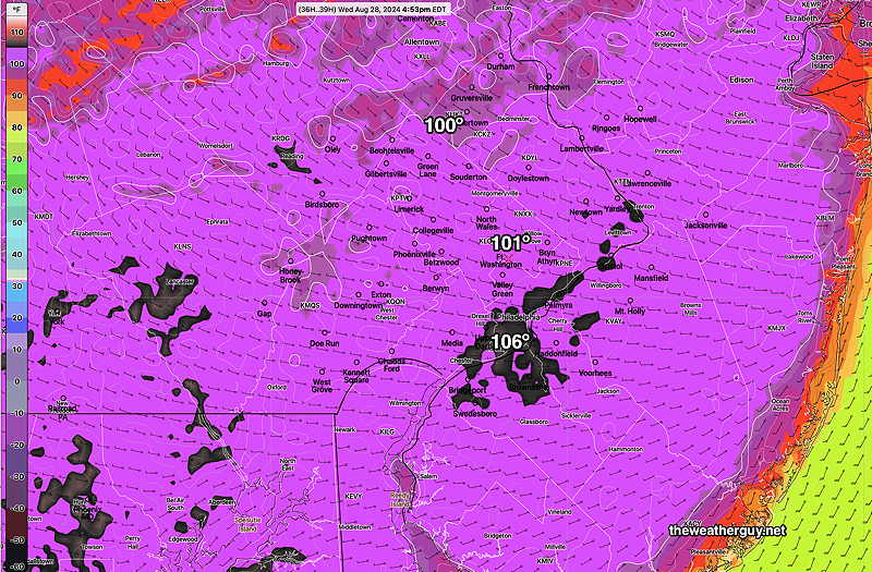
Posted Wednesday 08/28/24 @ 7:43 PM — So far, our area hasn’t seen any scattered storms. The current water vapor and radar shows storms developing to our north and southwest at 7:30PM—
Water Vapor and Radar with RAP model wind streams and vertical motion / moisture convergence. I’ve put a box around an area showing strong vertical motion. (Click on image for a larger view.)
The afternoon models have storms to our north and just to our south about 9-10 PM. I can see why. Nonetheless, there’s an area of strong vertical motion to our immediate northwest and it might lend a hand to some storm activity in our immediate area.
The models continue to have another batch of storms move through between 2AM and 6 AM, although the intensity expected has diminished from previous model runs.
Here’s the experimental RRFS forecast for 3 AM—
08-28-24 18z RRFS forecast for 3 AM. Precipitation, Precipitation Rate and clouds (black) (Click on image for a larger view.)
While some rain is possible in most areas, only a few areas will have much needed heavier rainfall.
Wednesday Forecast Update
Posted Wednesday 08/28/24 @ 9:45 AM — The thunderstorm and rain forecast for today remains below average confidence. The ECMWF continues to forecast minimal rainfall for the Philadelphia area.
Our NOAA models and the Canadian models had been forecasting a main group of storms moving through about 2-4 AM Thursday, with earlier scattered activity during the evening.
However the latest 12zHRRR just became available and it shows minimal rainfall and highly scattered activity. The experimental 00z and 06z RRFS continues to show a heavy group of storms moving through 2-4AM, but the 12z RRFS is not yet available.
So the trend is for minimal rainfall in the immediate Philadelphia area, a big shift from what was forecast yesterday and closer to the ECMWF. As mentioned in several previous updates this week, the models have been unusually inconsistent.
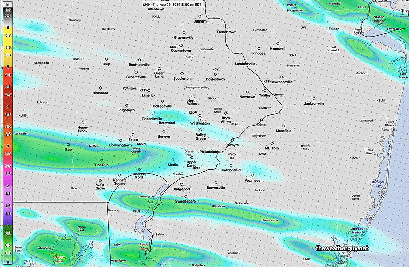
Here’s the latest HRRR total rainfall through 8 AM Thursday. The HRRR has all of this falling after midnight tonight —
Wednesday Forecast Update
Posted Tuesday 08/27/24 @ 5:29 PM — There continues to be large model differences in the forecast of showers and thunderstorms Wednesday late afternoon and Wednesday night. As a result, this is a low confidence forecast.
Basically, temperatures are still expected to reach 96º-97º or so, according to the latest NBM.
The big question is the timing and coverage of any showers and storms. The models have lacked continuity between themselves and their own previous runs.
Some models have storms developing and moving through late afternoon 4- 6 PM, mostly scattered. The HRRR and RRFS both have a large complex of storms moving through between 2 AM and 6 AM Thursday morning. The ECMWF showed this earlier, but the latest run has much of the rain skipping over the city.
The latest HREF and Canadian RGEM just available perhaps has the best compromise. Scattered storms starting as early as 4 PM, and scattered storms through the evening. Then a large complex of strong storms moves through 2-6 AM Thursday morning.
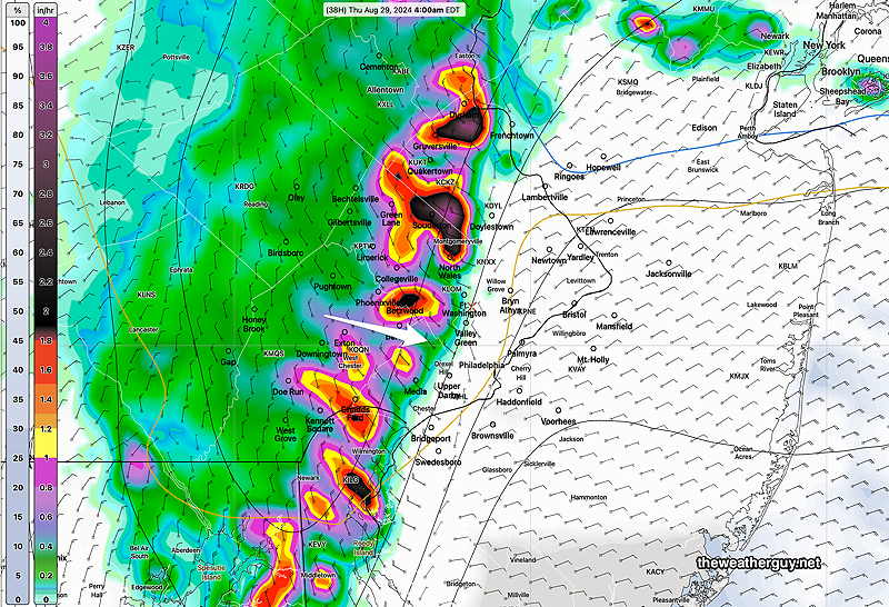
Here’s the current HRRR forecast for 5 AM Thursday —
18z HRRR Precipitation rate for 4 AM Thursday morning. (Click on image for a larger view.)
Wednesday Heat Update
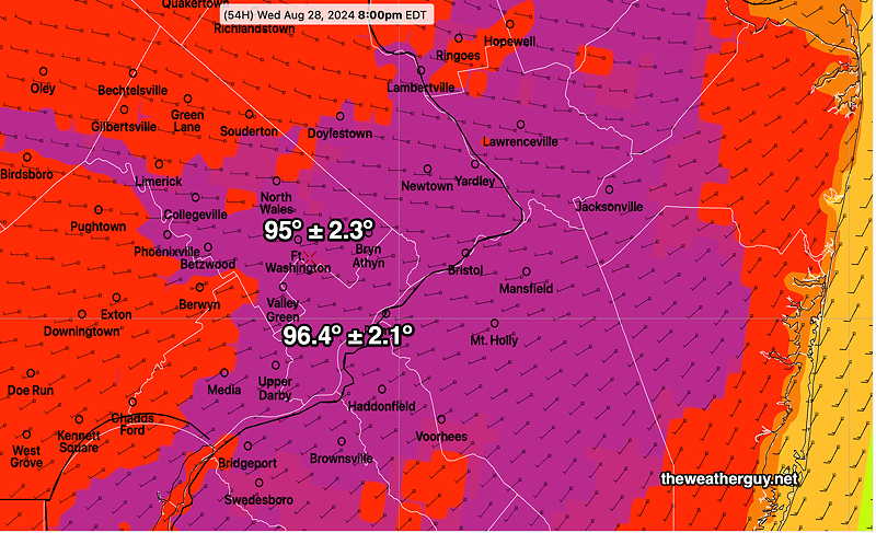
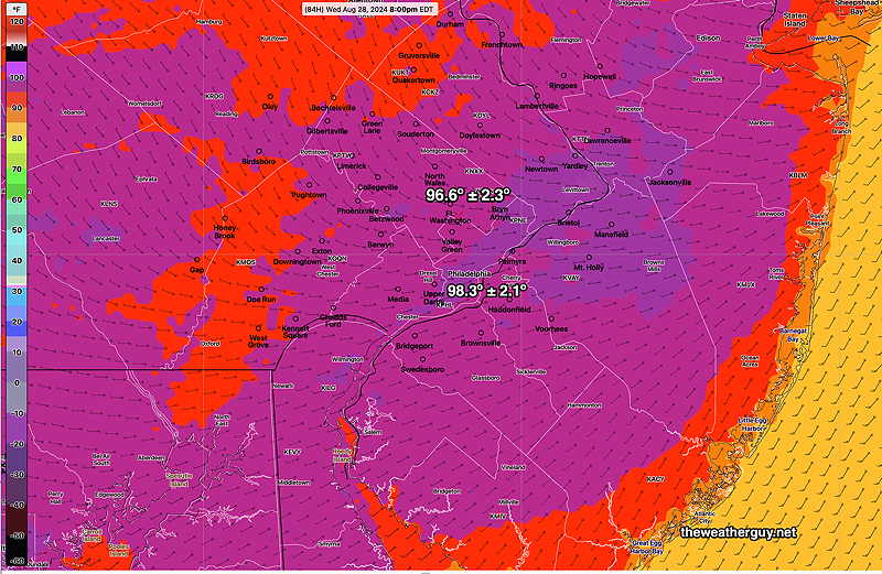
Posted Tuesday 08/27/24 @ 8:43 AM — The forecast continues to evolve for this week and the weekend. Wednesday continues to be a very hot day with high temperatures 96º (Blue Bell) -97º (Philadelphia). Dew points will be in the humid 70s and the heat indices will be over a 100º—
Here’s the NBM heat indices in the late afternoon Wednesday—
06z NBM heat index (“apparent temperatures”) on Wednesday afternoon. (Click on image for a larger view.)
Regarding potential rainfall, the forecast seems to change from day to day.
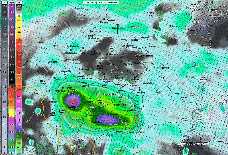
Last night’s models now have some heavy thunderstorms moving through the immediate Philadelphia area late Wednesday evening and into the after-midnight hours of Thursday. A significant short wave is expected to provide the energy for the showers—
06z Experimental RRFS simulated radar forecast for 4 AM Thursday morning. Heavy rain and thunderstorms move through. (Click on image for a larger view.)
The location and timing of the above is currently supported by the ECMWF model, but again, there’s been changes in this forecast almost daily.
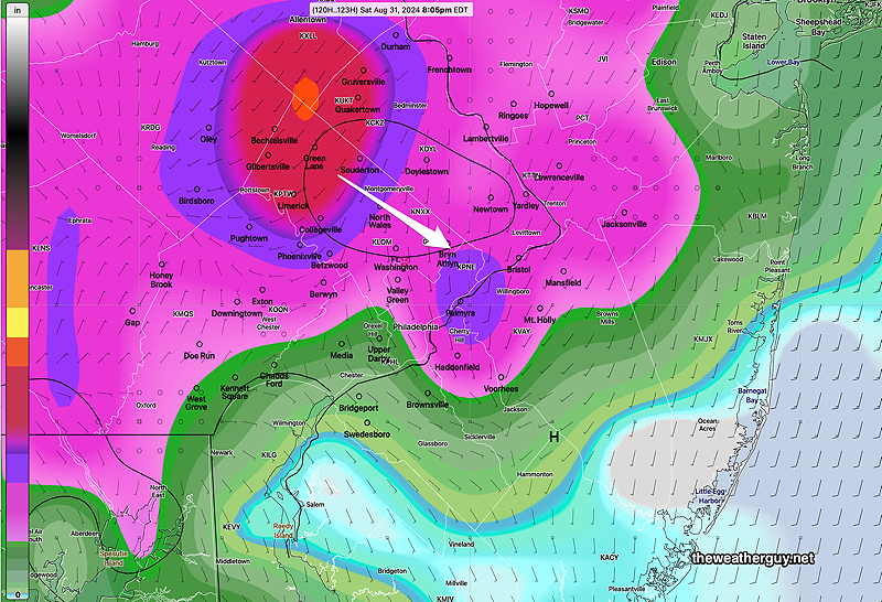
The ECMWF also shows more thunderstorms moving through Saturday evening—
00z ECMWF 3 hour rainfall forecast for 8 PM Saturday (Click on image for a larger view.)
There’s uncertainty with the rest of the Labor Day Weekend forecast. The front was originally expected to move way to our south, but may get hung up closer to us. A cool trend that looked almost certain for next week is not a certainty now.
Forecast Update
Posted Mon, 08/26/24 @ 7:22 PM— There’s been a few forecast changes since yesterday. High temperatures Wednesday will be somewhat lower than forecast yesterday, with highs 95º-96º. Dew points will be in the low 70s and the heat index will be over 100º.
Today’s 18z NBM high temperatures for Wednesday (Click on image for larger view.)
For those waiting for some decent rainfall, it now looks like it won’t happen late Wednesday through Thursday. It looks like the bulk of the rainfall stays west of the city. Some showers are possible here, but total rainfall looks to be less than 0.25″.
The Labor Day Weekend looks to be unsettled for Saturday and first half of Sunday. Plenty of clouds with some showers possible. I expect this forecast to change.
This Week and Labor Day Weekend Weather
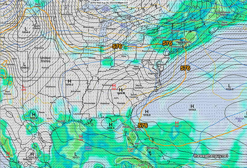
Originally Posted Sun @ 5:28 PM — —The cool weather we’ve been having for the past week will be replaced by possible record high temperatures Wednesday. The edge of the ‘heat dome’, which has been far south of our area, will move north of us by Tuesday into Wednesday.
Regular visitors to this site know I use the 576 thickness line (500-1000mb thickness) to demarcate the edge of the heat dome. It’s visible north of us by Wednesday—
NAEFS forecast for Wednesday at 5 PM (Click on image for a larger view.)
The NBM forecast high temperatures are in the mid to upper 90s on Wednesday!
NBM high temperatures Wednesday (Click on image for a larger view.)
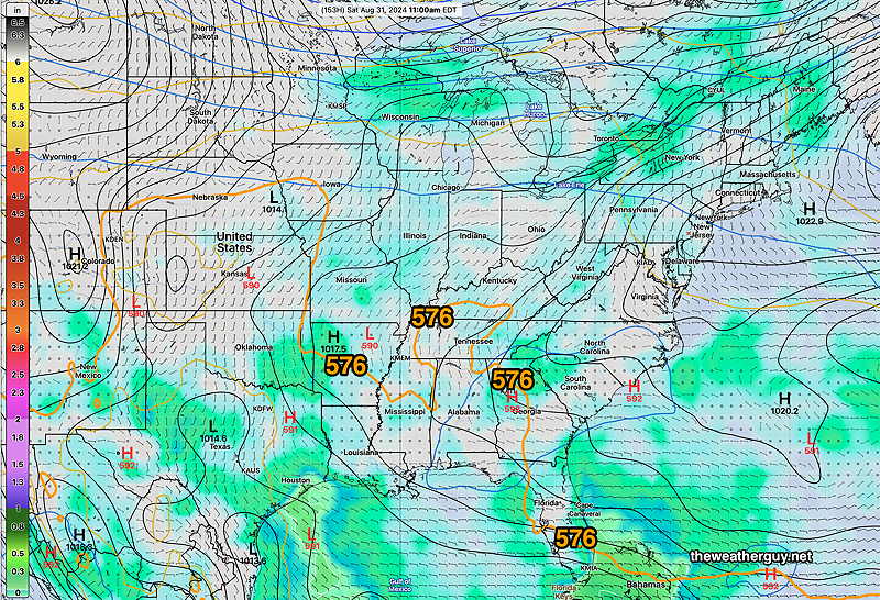
By Saturday a series of cold fronts will have moved through, the heat ( and the 576 thickness line) will be well to our south, and we’ll be returning to closer to ‘normal’ temperatures here —
Saturday (Labor Day Weekend) shows the heat dome well to south again. (Click on image for a larger view.)
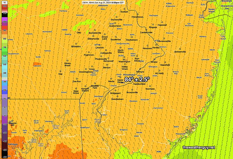
Next Saturday—
NBM high temperatures for next Saturday (Click on image for a larger view.)
A series of fronts may provide some light but much needed rain, possibly Monday night for southern parts of our area and again Wednesday night into Thursday morning. The rainfall late Wednesday night could be more substantial.
There is some uncertainty regarding the southward push of the cold front for next weekend. The front may stall to our south, with showers and thunderstorms for our area. The NAEFS forecast for Saturday above assumes a better weekend. This morning’s GFS has the front stalled to our south. Too soon to know for sure.
Update Sat 8/24 10:39 PM — A few models are showing widely scattered showers Sunday evening, dissipating just as they approach Philadelphia. The NAM-NEST and Canadian models have been consistent with this forecast, the HRRR, ECMWF and GFS show no showers. So just a possibility about 8 PM. Also, expect a fair amount of wildfire smoke haze in the afternoon.
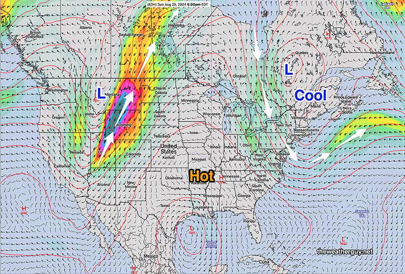
Originally Posted Fri 7:34 PM —A somewhat blocked weather pattern continues and we will continue to be in a dry, sunny stretch of weather through the weekend.
NAEFS jet stream level winds (300 mb) forecast for Sunday shows our area under a cool flow associated with an upper trough, while the mid section of the country remains under a hot ridge.
Showers are not expected until late Monday, and not all models are on-board with that.
Originally Posted Fri 7:34 PM —
Saturday Forecast
Sunny and pleasant.
NBM high temperatures: Blue Bell, PA 84º Philadelphia, PA 85º Uncertainty (based on standard deviation): average ± 1.2º
Sunday Forecast
Sunny and warmer. A few scattered clouds in the late afternoon.
NBM high temperatures: Blue Bell, PA 87º Philadelphia, PA 88º Uncertainty (based on standard deviation): average ± 1.7º