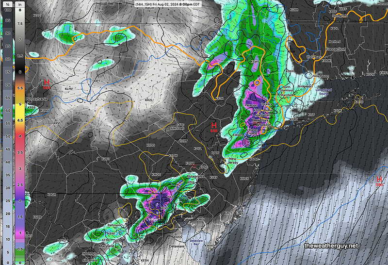
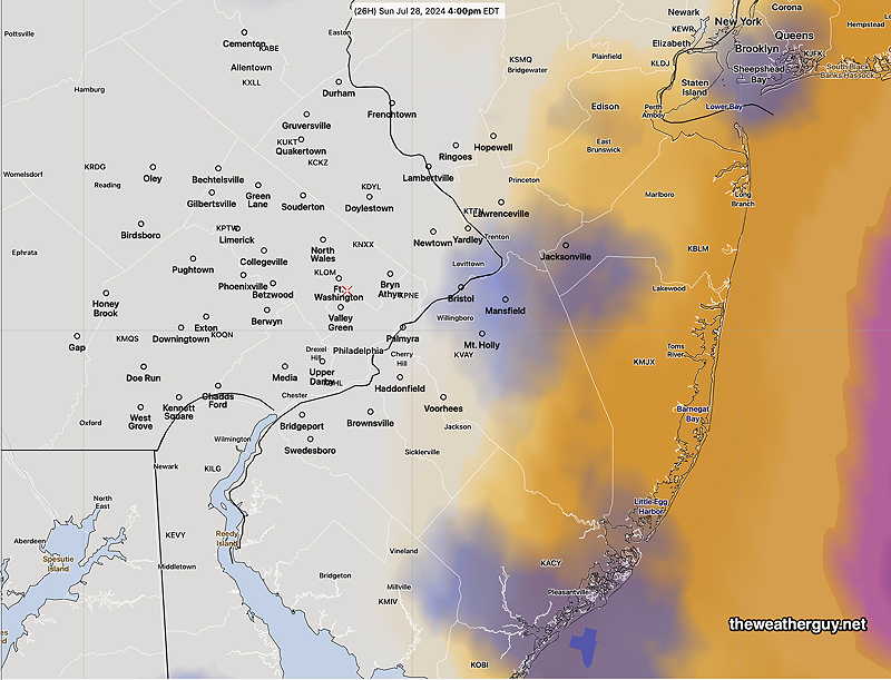
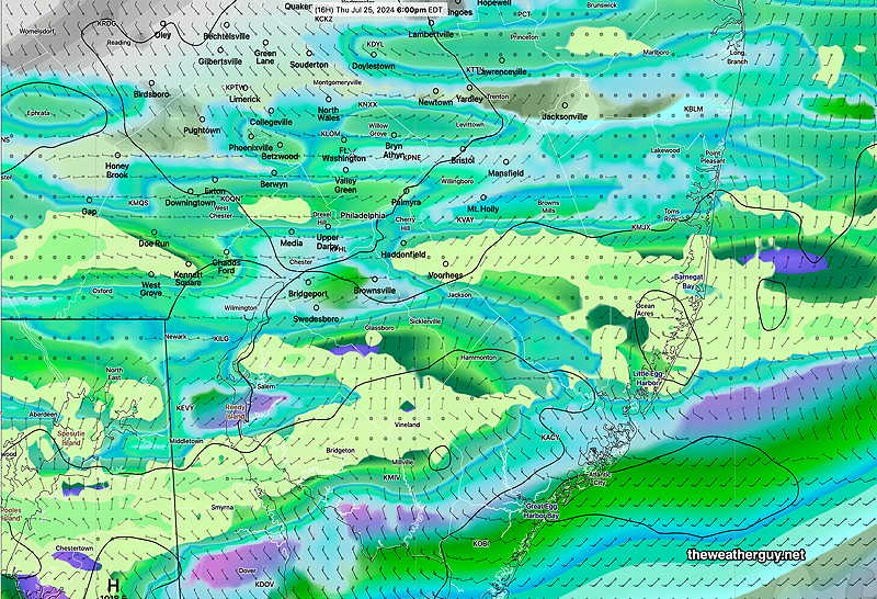
Posted Friday 08/02/24 @ 4:26 PM — Obviously, the models were about 3 hours too slow with the passage of the showers and thunderstorms. Indeed, the entire forecast from yesterday has changed; instead of the storms lingering and developing over the I-95 corridor this evening, this line of storms is now forecast to move east and away this evening.
Posted Friday 08/02/24 @ 12:57 PM — A quick update. This morning’s models have returned to forecasting some showers and thunderstorms in most areas. Most likely timing is- starting 5 PM or so in western Montgomery, Bucks and Chester counties, between 6-7 PM in Philadelphia and eastward into NJ. Heaviest rainfall is still forecast north and south of Philadelphia.
Posted Friday 08/02/24 @ 9:42 AM — What was looking like a slam-dunk drought-buster of a rainfall later today is now looking questionable. The latest HRRR shows most of the rain shearing off to our far northwest.
Just to see, I downloaded the latest hourly experimental RRFS 10z and it has heavier rain in some places, but also has large parts of the Delaware Valley with little to no rain! Here’s the latest RRFS—
10z RRFS has rain in southern and northern parts of the Delaware Valley. (Click on image for a larger view.)
To add to the uncertainty, the NAM-NEST and HRES are showing showers and storms right now, not occurring on actual radar. That undermines the rest of their forecasts. So an uncertain forecast. Some areas here will have some substantial rain, some will have little or none.
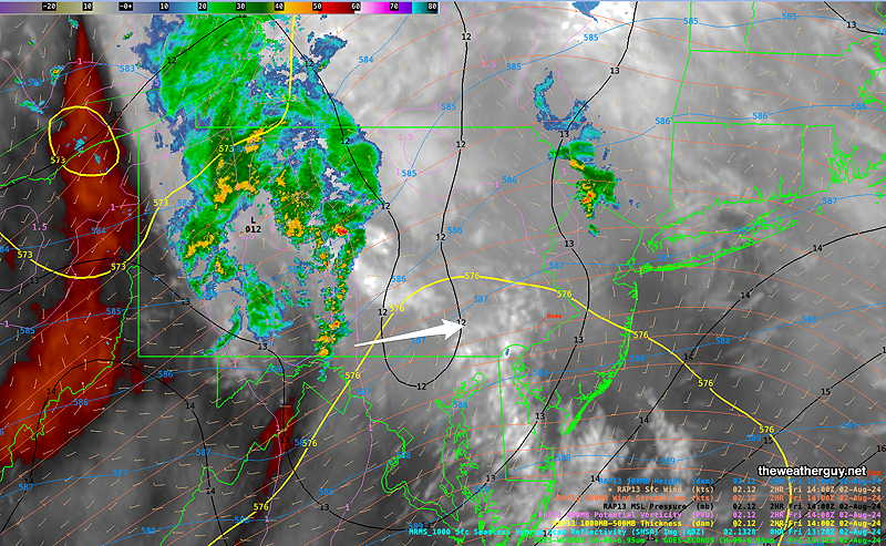
Current Water Vapor and MRMS radar at 8 AM with superimposed RAPthickness, MSL isobars and upper air windstreams. (Click on image for a larger view.)
I’ll update later.
A Pattern Change. Rain?
Posted Thursday 08/01/24 @ 4:59 PM — Just when I started to use the word “drought”, the models are forecasting a pattern change for the coming week. Additionally a tropical system is expected to form near Florida and the moisture may move up the coastline towards us next week.
We’ll see the first evidence of the pattern change late Friday and over the weekend— A deepening upper level trough will have embedded waves of low pressure bring showers and thunderstorms to our area—
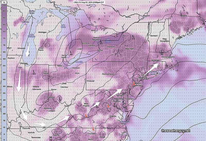
GFS Upper Air forecast (700mb ~ 10,000 feet) with relative humidity. The waves (L) will induce showers and thunderstorms as they rotate up through our area Friday evening and over the weekend.
For Friday, a mix of sun and clouds will still allow high temperatures to be 95º-96º. An increasing likelihood of showers and thunderstorms, from west to east from 2 PM into the nighttime hours. Yes, the rain is actually forecast for the immediate Philadelphia area.
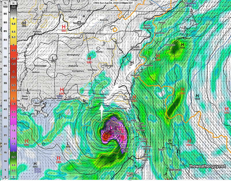
Additionally, a tropical system will form somewhere near Florida. It may or may not reach hurricane strength. The GFS has the storm quite developed by Sunday afternoon on the west coast of Florida. as does the Canadian Global. The ECMWF isn’t on the same page, though. So we’ll have to see what happens in the coming day.
12z GFS forecast for 2 PM Sunday (Click on image for a larger view.)
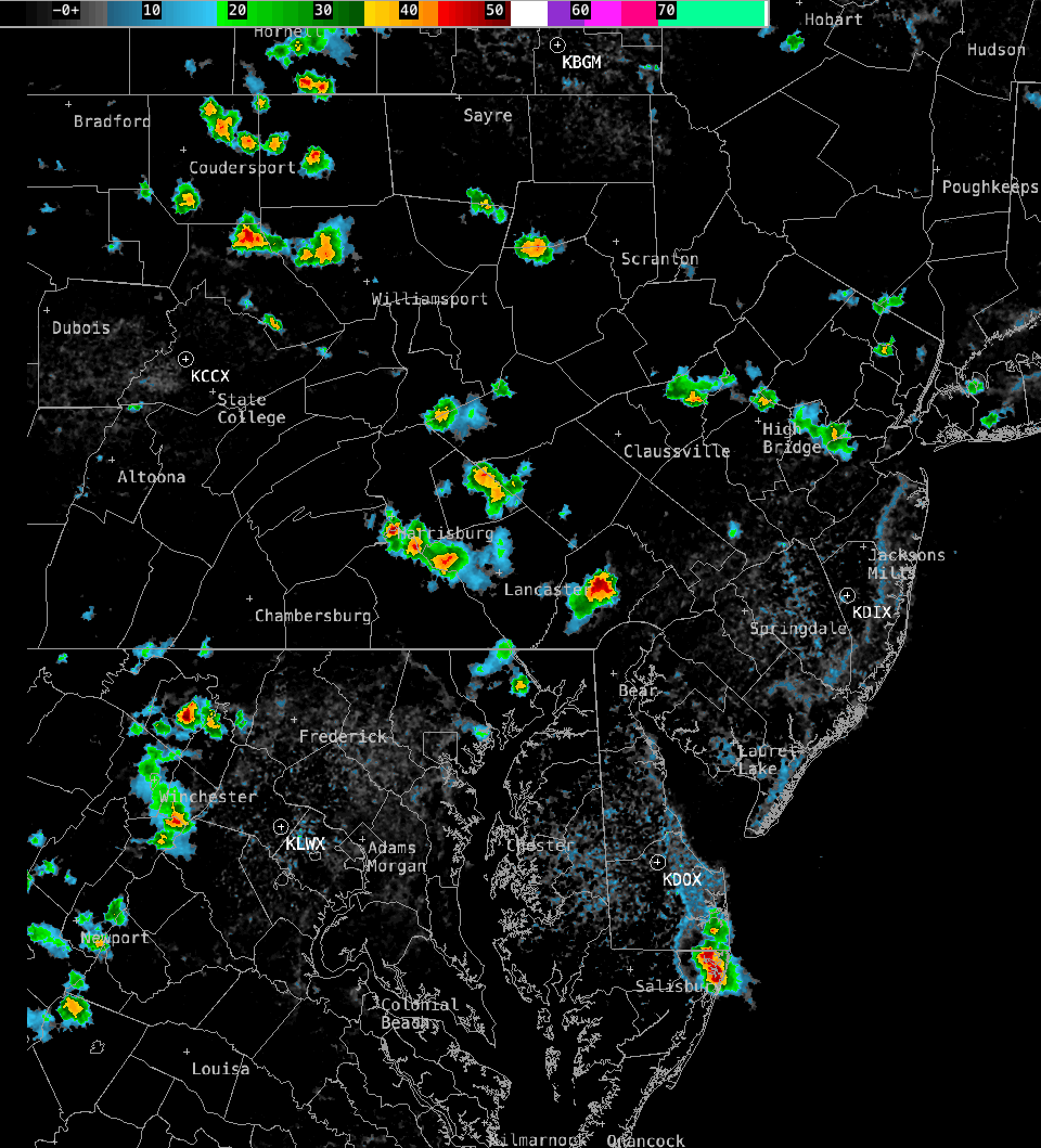
Thu 4:52 PM —Forecast Review — Once again, the strongest 500mb vorticity couplets predicted the general locations of the showers and thundershowers today, basically northeast and southwest of the Delaware Valley—
Radar at 4 PM (Click on image for a larger view and for animation.)
Things are usually more complex with thunderstorm development (moisture convergence, frontal movement, jet stream influence), so I don’t think this is any magic forecast solution.
Hot Thursday
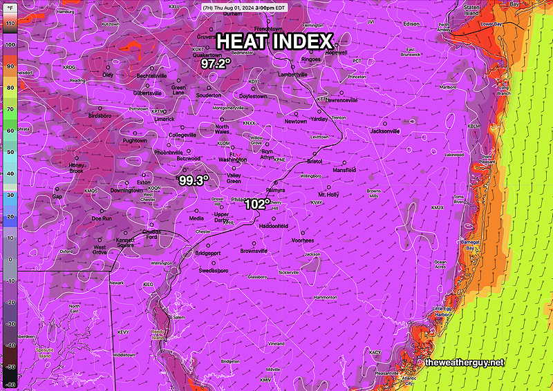
Posted Thursday 08/01/24 @ 11:12 AM — Today’s high temperatures will be between 95º and 97º, depending upon your location. With forecast dew points in the upper 60s to low 70s, the apparent temperature (heat index) in most areas will exceed 100º—
This morning’s 12z NBMapparent temperatures at 3 PM (Heat Index) Contours are 1º F (Click on image for a larger view.)
Thunderstorms, if any, look to be even more isolated than yesterday.
Yesterday’s NAM-NEST 500 mb vorticity was pretty good at identifying the likely areas for development of showers. Storms will be less likely and more isolated. Likely development is 3:30 PM to 6 PM. Today, we’ll use the experimental RRFS absolute vorticity—
Today’s 06z experimental RRFS 500 mb absolute vorticity. Red-Violet vorticity couplets indicate strong vertical motions. Red boxed areas are most likely to see isolated showers/storms between 3:30 PM and 6 PM. (Click on image for a larger view.)
Showers Thundershowers?
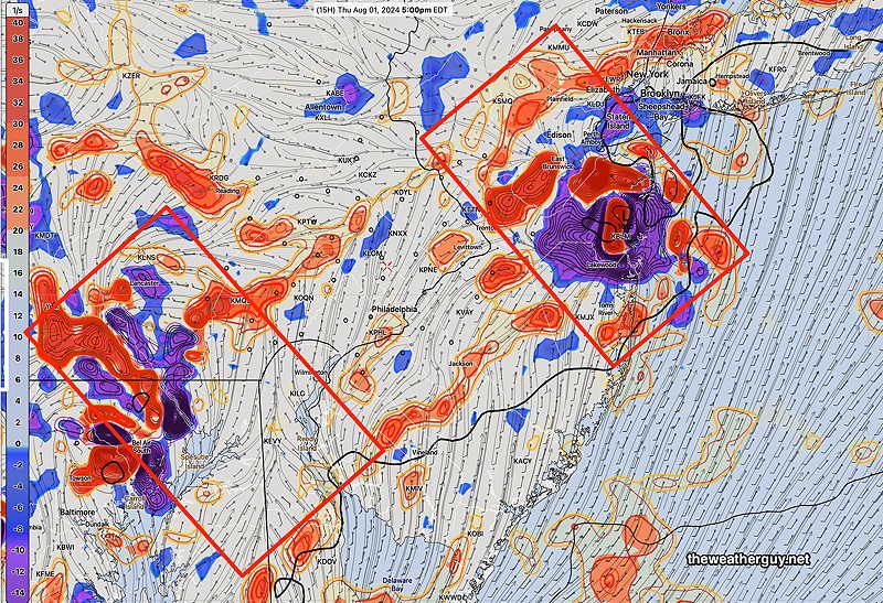
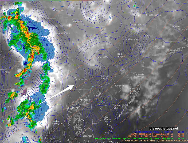
Wed 5:43 PM —Forecast Review — Showers and storms did develop east of the I-95 corridor as suggested by the morning’s NAM-NEST—
NexRad Radar with “Q-Vectors” indicating upward and downward motion. (Click on image for a larger view.)
The showers west of the city died out as they approached.
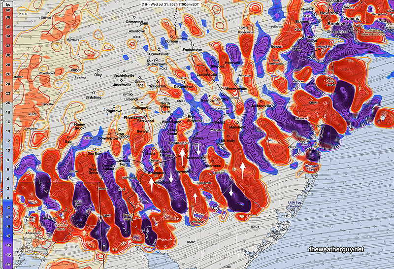
Posted Wednesday 07/31/24 @ 1:47 PM — A review of upper air parameters suggests showers and thundershowers between 4 and 8 PM from the city and eastward. Here’s the NAM-NEST
NAM NEST model absolute vorticity at 7 PM Red-blue couplets of negative and positive vorticity usually is a strong signal for precipitation. Then again, we’re in a dry period. (Click on image for a larger view.)
Our Dry Weather
Posted Wednesday 07/31/24 @ 9:29 AM —The warm front went through last night; the rain and dynamics sheared off to our northwest.
We’ve been in an extended pattern where storms dissipate as they approach the Philadelphia area resulting in very dry conditions locally.
I’ve seen this before and I have, in the past, passed along several theories for the phenomenon, none of which totally satisfy. Most recently, this occurred in the summer of 2022.
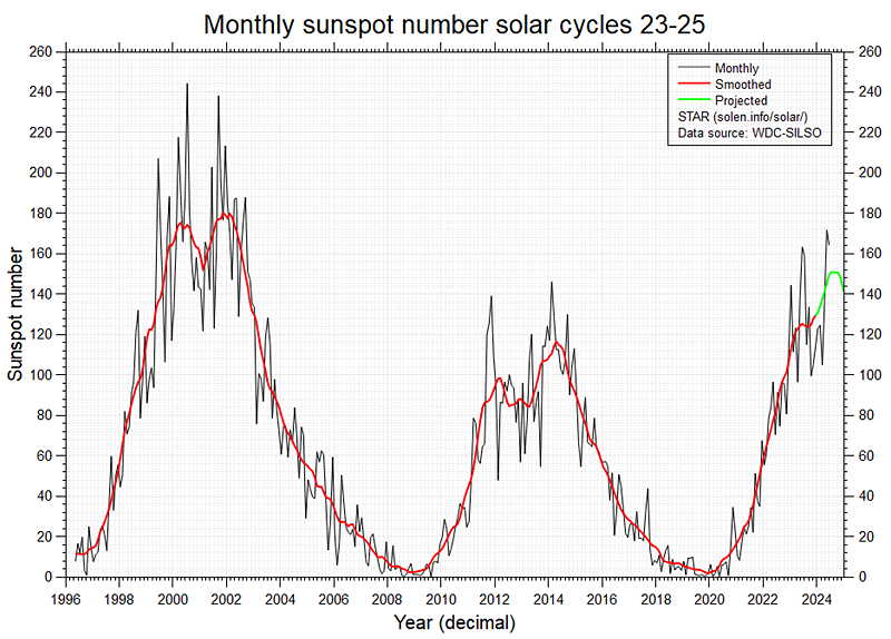
The overall feeling is that “dry begets dry” and the lack of soil moisture is a negative feedback loop for thunderstorm (convection) development. The other factor, although esoteric, are the dry patterns associated with the upswing in the sunspot cycle, although we are just past peak—
As an additional thought, they call our area the Delaware Valley for a reason; there’s a drop off in geographic altitude as we move east from Berks and Chester counties to the coastal plain of New Jersey. That descent results in air moving downward, negating any weak upward motion that was available for rain and convection.
None of these fully explain the purely local phenomenon of repeated collapse of thunderstorm development in the immediate PHL area during some seasons.
As for today, Wednesday, the models are showing a chance of isolated showers in NJ and northward near Lehigh county late afternoon. Hot and humid is the story for today.
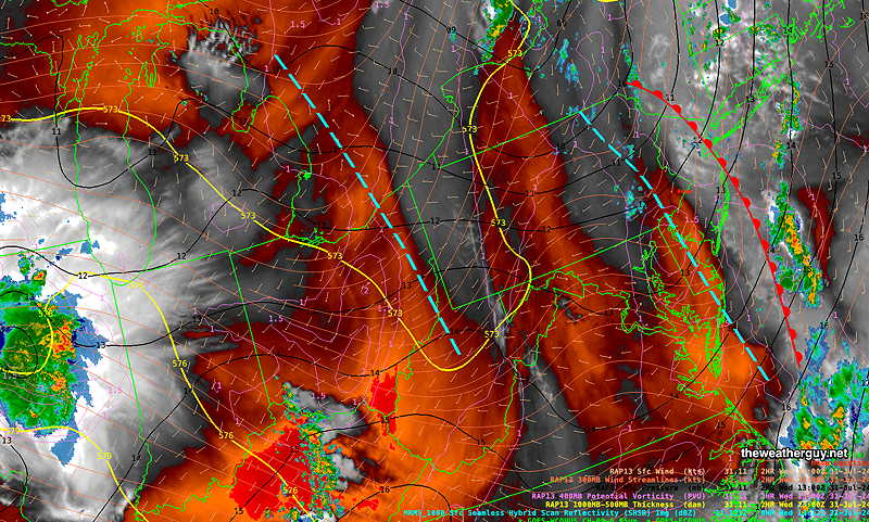
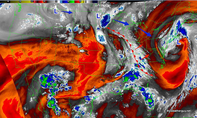
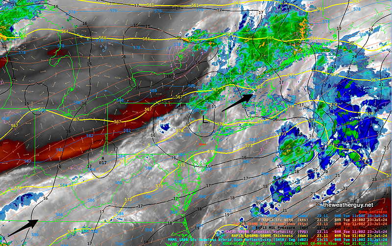
Current satellite water vapor image with superimposed RAP model 500-1000 mb thickness lines (yellow), Mean Sea Level Pressure isobars (black contours) potential vorticity (fine violet contours) with superimposed MRMS RADAR. I’ve drawn in the departing warm front the the two small upper air troughs (blue dashed lines) (Click on image for a larger view.)
Update
Posted Tuesday 07/30/24 @ 9:52PM — Tonight’s models have backed away from the showers and storms tonight. They are falling apart as they approach our area. The latest HRRR has little rainfall. How do you spell the word “DROUGHT”?
Posted Tuesday 07/30/24 @ 5:36 PM — The models are still showing showers and embedded thunderstorms to move through between 9 PM and 1 AM. Current MRMS radar—
MRMS radar image 5 PM with RAP model Omega (vertical motion) contours (blue) and WV. (Click on image for a larger view.)
Additional scattered showers expected through the night and through much of Wednesday as the warm front moves through and an upper trough moves through.
I wish I felt more confidence that we will actually see some rain here.
Tuesday Forecast
Posted Tuesday 07/30/24 @ 11:12 AM — As a forecaster, yesterday was a disappointment; It’s not common to see every model be wrong forecasting showers and thunderstorms for late afternoon into the evening.
So, I today, I’ve waited to post the forecast in order to see the morning models. I heard on the radio this morning about showers and thunderstorms during the daytime. I don’t think so.
A warm front is approaching today and this morning’s models keep us dry during the day—
Current satellite water vapor image with superimposed RAP model 500-1000 mb thickness lines (yellow), Mean Sea Level Pressure isobars (black contours) potential vorticity (fine violet contours) . I’ve drawn the approximate location of the warm front. (Click on image for a larger view.)
A line of showers and thunderstorms is forecast to move through from west to easttonight between 9 PM and 1 AM. No severe weather currently expected, although some areas may have some heavy rainfall. (Wouldn’t that be nice!)
We’re heading into another heat wave once this warm front clears our area. Expect temperatures on Friday to be in the upper 90s to close to 100º
Forecast Update
Posted Monday 07/29/24 @ 5:40 PM — Despite most models showing scattered to isolated showers and storms for late Monday afternoon, current radar isn’t showing these showers and water vapor imagery doesn’t show any well-defined triggers at this time.
An isolated shower is still possible through 9 PM, but I wouldn’t count on one.
Monday Forecast Update
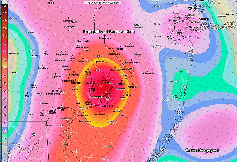
Posted Monday 07/29/24 @ 10:04 AM — This morning’s models are consistently forecasting isolated showers and thunderstorms developing between 3 PM and 9 PM this evening, as a result of a disturbance rotating around the upper closed low that has moved to our northeast.
Here’s the HREF probability of radar echoes > 40db at 8 PM—
HREF probability of radar echoes> 40db at 8 PM The probability is not related to areal coverage. All areas in the max zone won’t necessarily see any rain at 8 PM. (Click on image for a larger view.)
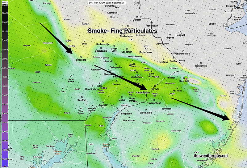
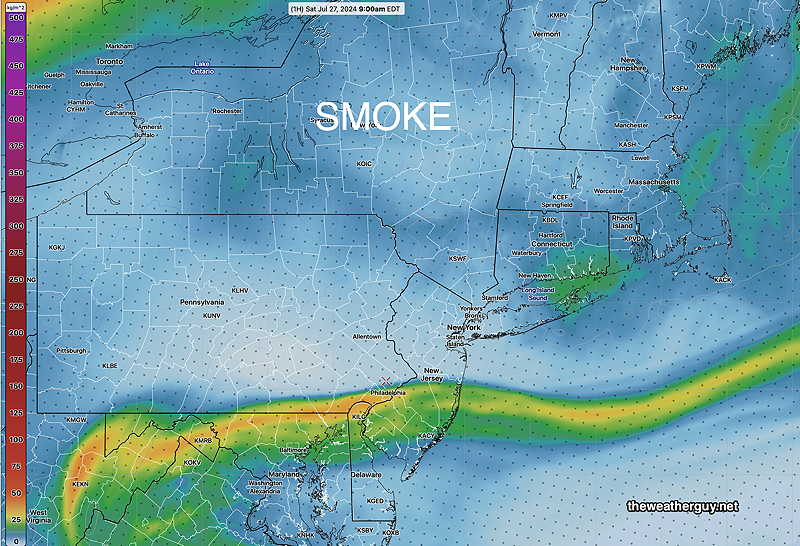
We’ll also notice some smoke today. The HRRR shows a peak about 3 PM as plume moves through.
HRRR smoke model at 3 PM. Half atmosphere level. (Click on image for a larger view.)
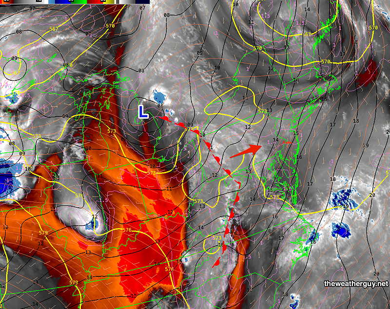
Originally Posted Sun @ 8:01 PM — Our weather this week will be influenced by a upper level trough over the northeastern US with several disturbances passing over the upper level ridge in the central US. An advancing warm front will add to the mix—
Sunday’s Water Vapor image with drawn warm front. Several disturbances (L) will move across the central US ridge and Combined with an approaching warm front and cyclonic flow over our area will result in unsettled weather and showers/thunderstorms through at least Wednesday. (Click on image for a larger view.)
The timing and placement of the showers are likely to change over the next day or so, but expect unsettled weather.
For Monday, clouds and some sunshine. Some scattered showers/storms expected Monday afternoon.
More widespread rain/thunderstorms are likely Tuesday, Tuesday night and Wednesday.
Posted Sunday 07/28/24 @ 10:00 AM — Except for the HRRR, the models are holding back the clouds at the shore until this evening. Sunny skies with haze from wildfire smoke here in the city. (The smoke levels here are not anywhere near the levels of last summer. )
The upper level low to our east will result in some instability showers/thundershowers late Monday afternoon. Increasing chances of showers and thunderstorms Tuesday and Wednesday due to an approaching warm front.
Forecast Update
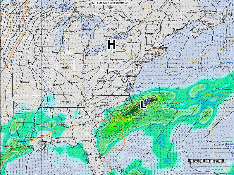
Posted Saturday 07/27/24 @ 5:20 PM — Today’s ample supply of “fair weather clouds” were courtesy of the upper level cyclonic flow around the developing closed low, as discussed below.
The forecast for Sunday remains mostly on-track. There will probably be more “fair weather cloudiness” around the city and this afternoon’s higher resolution models are predicting increasing high and mid level cloudiness at the Jersey shore about 3 PM—
Today’s 18z NAM-NEST cloud forecast for 4 PM Sunday. (Low clouds- blue, mid-level clouds- maroon, high clouds- yellow tan) (Click on image for a larger view.)
Posted Saturday 07/27/24 @ 9:32 AM — Last night’s ECMWF has backed away from a strong westward movement of the upper closed low on Sunday; it has joined most of the other models with a northward or west-northwest motion.
As a result, clouds with this system should remain offshore until Sunday late afternoon or evening. (Only the experimental RRFS has cloudiness at the shore Sunday afternoon.)
FYI, some of the haze in the sky over the past day or so is from smoke and particulates from the wildfires in Jasper Canada. A plume sunk south of us this morning—
12z HRRR smoke – integrated vertical column smoke/particulates . (Click on image for a larger view.)
An general increase in smoke particulates is forecast. Smoke at the ground level is not currently forecast.
Originally Posted Fri @ 5:24 PM — —This looked to be a weekend where the forecast required no meteorologist; anyone could make a slam-dunk forecast for sunny skies both days with just a barometer and a wind vane.
However, things are looking a bit more interesting for later in the day Sunday, especially at the Jersey Shore.
First, high pressure builds in for Saturday with sunny skies—
NAEFS model statistical “mode” version with overlayed GEFS model “bias-corrected” precipitation forecast for Saturday. (Click on image for a larger view.)
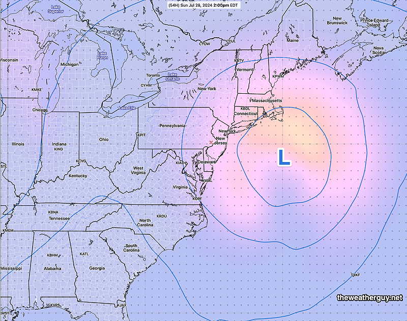
For Sunday, there’s now some uncertainty regarding the cloud cover, especially east towards the Jersey shore on Sunday afternoon due to the formation of a closed low in the mid and upper atmosphere—
NAEFS upper 500 mb mid-level closed low Sunday 2 PM. This may cause cloudiness east into NJ and at the Jersey Shore. (Click on image for a larger view.)
The position of this closed upper low is also uncertain, with the latest ECMWF model having it closer to the coast and with a track that retrogrades it westward going into Monday.
So not a slam dunk forecast. Still likely sunny and quite nice in Philadelphia.
Saturday
Sunny and quite nice. Warmer.
NBM high temperatures: Blue Bell, PA 87º Philadelphia, PA 88º uncertainty (based on standard deviation): very low ± 0.9º
Sunday
Mostly sunny in the morning, some increasing cloudiness in the afternoon, especially east towards the Jersey Shore. Slightly more humid with dew points near 60º
NBM high temperatures: Blue Bell, PA 89º Philadelphia, PA 90º uncertainty (based on standard deviation): very low ± 0.9º
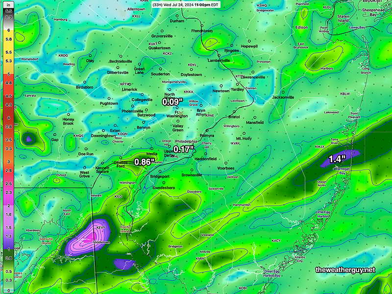
Posted Thursday 07/25/24 @ 6:56 PM — The majority of models got it right today with the rain suppressed to the south and east; the exceptions were the Canadian RGEM and HRDPS which were surprisingly very wrong.
There’s a slight change in forecast for Friday. The front will hang up a bit to our south. There will be sunshine on Friday, but sunshine through high cirrus clouds. especially from the city southward. Areas to the north of the city will have blue skies.
It looks like sunshine and blue skies return for Saturday and Sunday.
Posted Thursday 07/25/24 @ 8:52 AM — No significant change in the forecast. The vast majority of today’s models continue to show showers in areas southeast of the city, in Delaware, Maryland and southern South Jersey. The exceptions, not to be ignored, are the Canadian RGEM and HRDPS, which show some showers as far north as Philadelphia. The timing is between 3 PM and 6 PM.
Here’s the HRDPS precipitation forecast through 6 PM. An outlier of a forecast, but the HRDPS has a history of sometimes being correct with when the NOAA models show no precip—
06z HRDPS total precip by3- 6 PM tonight. The lighter yellow-green is convective (thunderstorm) precip. Just food for thought…this forecast is an outlier. (Click on image for a larger view.)
CommentaryPosted Wednesday 07/24/24 @ 4:53 PM — I’ve been wondering when all those hurricanes predicted for this season are going to form?
There’s still one more week in July, but there will need to be a significant increase in tropical activity in August, September and October to reach the expected number of named Atlantic storms forecast this season. Somehow, I expected more activity by this time.
Right now, the Atlantic is quiet. Seems somewhat strange.
Forecast Update
Posted Wednesday 07/24/24 @ 4:32 PM — A few upper air disturbances triggered showers today, but the heavier rainfall was spotty and was not enough to break the rainfall deficit we’re in.
A few additional showers are developing late this afternoon and evening ahead of a surface front moving through tonight.
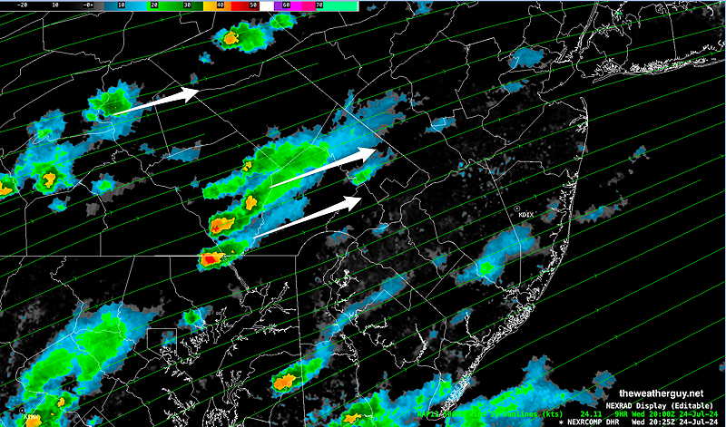
NEXRAD radar 4 PM Wednesday
Winds will shift to the west and then northwest during the day Thursday reducing the chance of showers to isolated, as drier air moves in. The upper level trough still has to move through, so periods of lingering clouds mixed with some sun are expected. Heavier showers possible in Delaware.
Friday looks to be sunny and seasonably warm with much lower humidity.
Wednesday Forecast
Posted Tuesday 07/23/24 @ 5:54 PM — As I had forecast this morning, our area didn’t have any showers or thunderstorms; we had considerable sunshine.
As for showers, there’s a wide range of model forecasts, but overwhelmingly the trend is for any heavy rain to be south and east of Philadelphia. The latest HREF captures this—
18z HREF model showing total precip forecast through 11 PM Wednesday evening. Light precip is unlikely to change our overall dry conditions. (Click on image for a larger view.)
Earlier models had forecast some heavier showers in the immediate Philadelphia area before daybreak Wednesday into the morning hours. The latest Canadian models have backed off of that, but I think it’s still a possibility, based on the HREF.
More definite is the chance of scattered showers and thunderstorms, late morning, early afternoon and especially Wednesday evening.
As I’ve been saying for several days, this pattern is diffuse and the triggers are mostly upper air disturbances that are difficult to predict and time. Check back Wednesday morning for an update.
Tuesday Update
Posted Tuesday 07/23/24 @ 9:00 AM — Some areas had showers Monday night but most of our area received little rain.
For today, Tuesday, the clouds we have may break for some sun or sunshine through clouds. Despite the forecast I heard on the radio this morning, I don’t see much in the way of showers or thunderstorms during the daytime hours today, based on the models.
That said, there are disturbances in the upper air flow that could theoretically result in showers, so no guarantees of a dry day.
Current satellite water vapor image with superimposed RAP model 500-1000 mb thickness lines (yellow), Mean Sea Level Pressure isobars (black contours) potential vorticity (fine violet contours) with superimposed MRMS RADAR. The weak low over northeastern PA will exit. The next round of showers this evening is at the bottom left corner of the image. (Click on image for a larger view.)
There’s much more chance of showers and storms tonight, especially south and east of the city.
Tuesday Outlook
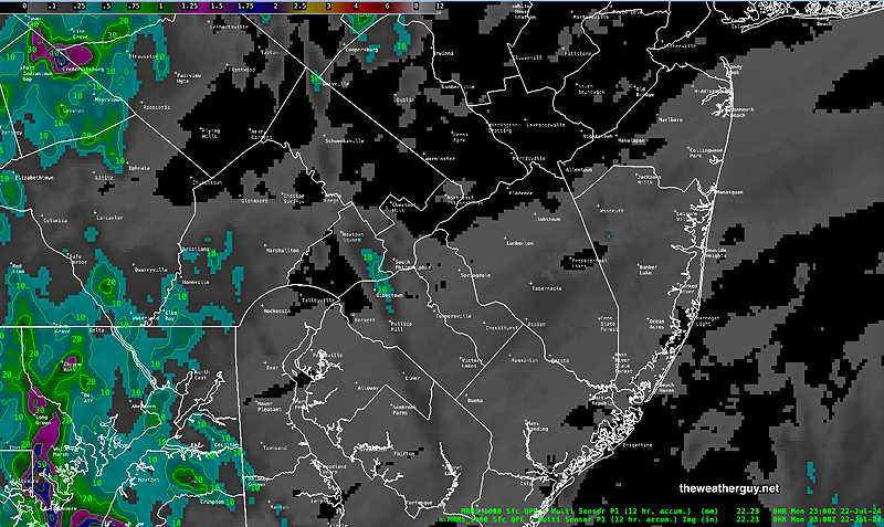
Posted Monday 07/22/24 @ 7:30 PM — The first round of rain on Monday mostly missed the Philadelphia area and immediate surrounding counties. Here’s the MRMS Precipitation Estimate for the past 12 hours—
MRMS rain-gauge measured rainfall combined with rain-gauge calibrated and interpolated radar-based summary of ACTUAL RAINFALL RECEIVED. Color shading is in inches. Line contour numbers are in mm. (25.4 mm= 1 inch) (Click on image for a larger view.)
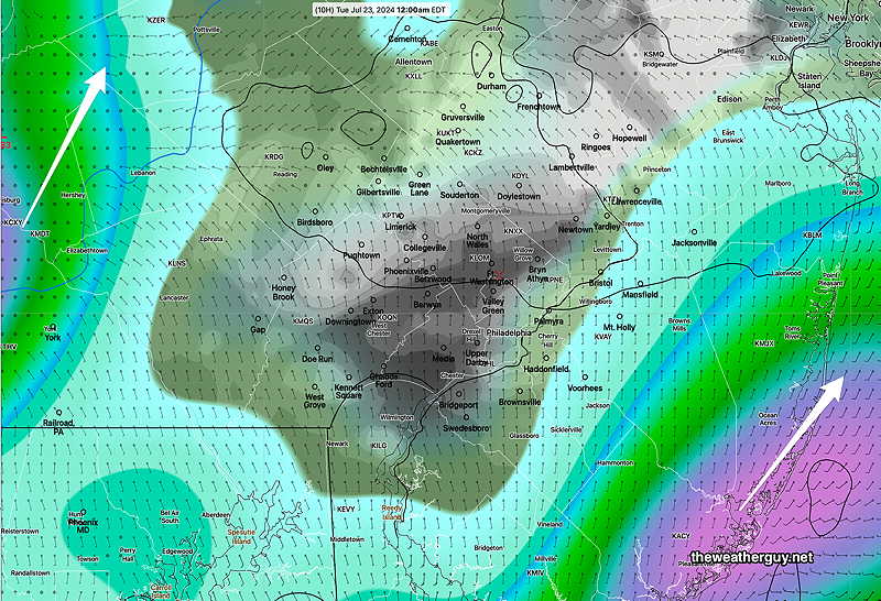
While some showers are moving in this evening, most of the rain this evening will remain to our west… and to our east. The latest HRDPS captures this—
18z HRDPS shows rain in NJ and in Central PA tonight. Little activity right here near Philadelphia. Just clouds (black grey) and light showers. (Click on image for a larger view.)
The daytime on Tuesday looks to be just cloudy with perhaps some sun through high and mid-level clouds. There’s a chance of showers mostly north of our area.
I’m going to be taking the forecast day by day. This weather pattern is a bit too diffuse to try to forecast more than 36 hours in advance. It does look like more rain is likely on Wednesday, timing to be determined.
Monday Update
Posted Monday 07/22/24 @ 9:04 AM — Based on last night’s models, the main bolus of rain will come in this evening and its trajectory is to keep the heaviest rain south and east of the immediate Philadelphia area.
That’s probably correct in part, but the latest radar shows showers and some embedded storms several hours ahead of the model forecast—
Radar/MRMS at 8:45 AM Monday (Click on image for a larger view.)
Getting the timing right with this system is going to be a challenge. But I would expect some spotty showers by early this afternoon and sooner in South Jersey. It doesn’t look like this first bolus of rain today will impact our overall dry conditions.
Originally Posted Sun 9:16 PM —An upper level trough combined with a stationary front to our south will result in unsettled conditions for much of this upcoming week.
A moisture riding over the stalled front will bring showers and possible thundershowers late Monday morning and continue for the balance of the day. Showers will be spotty in our area, while areas west (central PA) will have heavier rainfall.
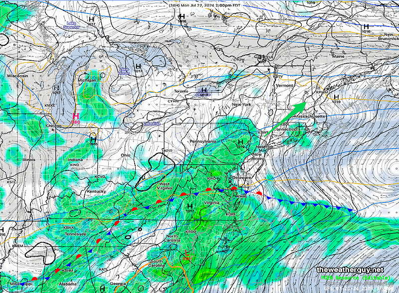
Weak low pressure will form on Tuesday.
GFS forecast 2 PM Monday. (Click on image for a larger view.)
Additional waves of low pressure and moisture moving over the stalled front will bring additional periods of shower, rain and thunderstorms Tuesday through Thursday. Exact timing of these waves of moisture and the axis of heaviest rain to be determined.
Right now, the heaviest activity seems to be timed for the evening and nighttime hours, but that could easily change.