Posted Thursday 08/15/24 @ 5:29 PM — As expected, the forecast for the weekend continues to change. The trend is for the next system to approach slower than previously forecast. First, let’s talk about Friday.
Friday is looking sunny with high thin cirrus clouds in the afternoon. (The haze you may noticed Thursday is wildfire smoke and particulates. Friday will likely continue to have haze from smoke.) No rain.
Saturday‘s forecast has changed. Originally, Saturday was expected to have showers during the day. Now, the forecast is for showers moving into western sections late afternoon or early evening. Most of the area will be dry during the daytime. It will be cloudy early but the cloudiness will likely break for periods of sun at times. Showers and thunderstorms will move in late evening or after midnight in the city as a warm front approaches.
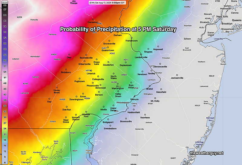
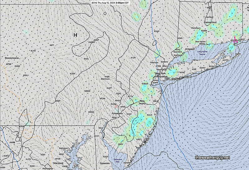
NBM probability of precip at 5 PM. Most of our area is dry on Saturday. Western portions of Montco Bucks and Chester counties may have some showers late afternoon. These are hourly probabilities; anything greater than 18% is usually a good bet for showers (green yellow) (Click on image for a larger view.)
Sunday looks to be cloudy with showers and thunderstorms likely. The heaviest and most widespread rainfall is expected later in the day and evening into Monday. The rainfall may not reach the Jersey Shore until later in the afternoon.
I’ll fine tune with my regular Weekend Weather Forecast tomorrow.
Posted Wednesday 08/14/24 @ 8:33 PM — The weekend forecast continues to evolve; the expected proximity of Hurricane Ernesto to our area will likely effect the accuracy of the forecasts. Tropical systems seem to change the weather in ways that the weather models don’t seem to capture correctly. Expect forecast changes.
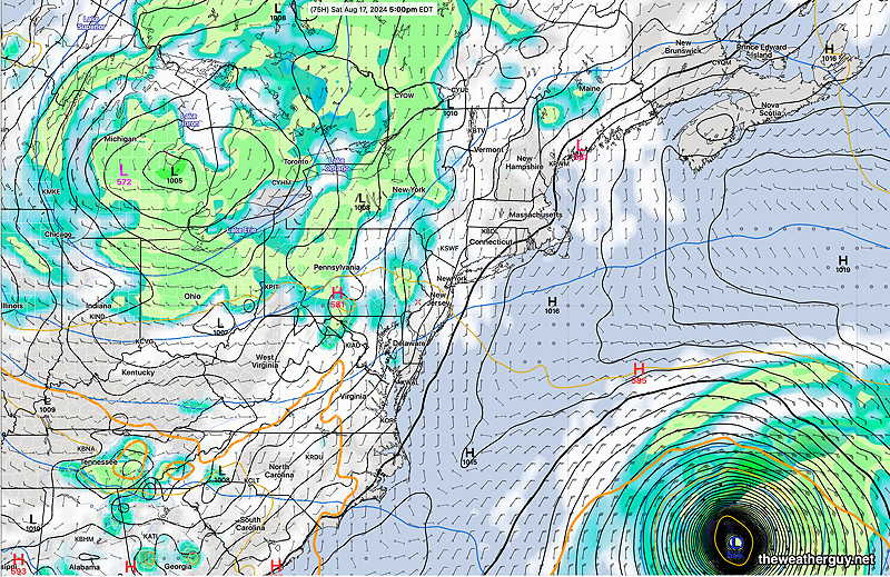
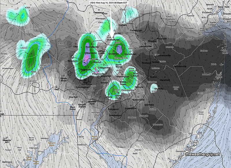
Today’s 18zGFS forecast for 5 PM Saturday. Rain and thunderstorms mostly just west of Philadelphia. (Click on image for a larger view.)
Some of the current forecast changes and trends—
Thursday looks to be warmer still, with highs near 87º-88º.
Friday will have more sunshine than had been forecast earlier in the week. Clouds won’t move until evening. Highs may reach 90º
Saturday will have a mix of clouds and some sun. Showers and thundershowers will reach the western suburbs during the late afternoon.
Sunday will have heavy rain and thunderstorms.
The Haze You’re Seeing is Smoke
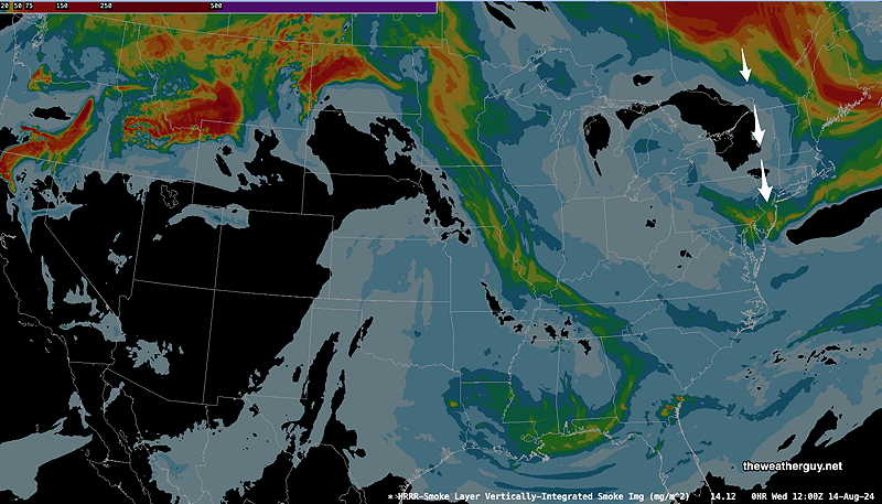
Posted Wednesday 08/14/24 @ 9:22 AM — The haze you’re seeing this morning is smoke from wildfires in Canada. Here’s two views of the HRRR smoke model—
Vertically Integrated Smoke 8 AM (Click on image for a larger view.)
Here’s another view—
HRRR smoke model – vertically integrated smoke (Click on image for a larger view.)
Another heavier plume of smoke is forecast to arrive about 6 PM today.
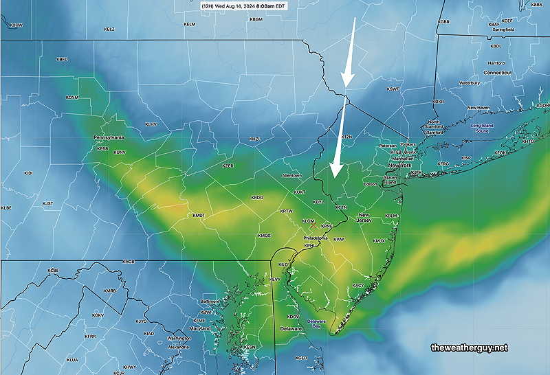
In addition to warmer temperatures today, some models continue to forecast scattered showers early this evening, that dissipate as they move further southward—
RRFS experimental Precip and clouds at 8 PM Wednesday. (Click on image for a larger view.)
Tuesday Weather Outlook Update
Posted Tuesday 08/13/24 @ 11:45 AM — Today, Tuesday, is another beautiful day. A few instability clouds are expected at times this afternoon. Some of the high resolution models have consistently forecast a highly isolated shower in a few spots for 5-7PM. A low confidence possibility.
Similar, even warmer days for Wednesday and Thursday. Each day has an increased possibility of isolated showers in the late afternoon.
08-13-24 12zRGEM forecast for Thursday afternoon at 3 PM. Isolated showers/thundershowers. (Click on image for a larger view.)
Friday looks to be dry with an increase in cloudiness from the next system from 3-6 PM.
Weather Outlook Update
Posted Monday 08/12/24 @ 7:51 PM — We had a bit more instability cloudiness than originally forecast and some instability cloudiness Tuesday afternoon is also expected.
The weather still looks very nice through Thursday with mostly sunny skies and instability cloudiness in the afternoon.
The next system will be approaching during the day Friday. It looks like some cloudiness is likely by Friday afternoon. Most models keep us dry through the daytime Friday, but some of the ensembles and the ICON model suggest the showers may move in late Friday afternoon.
The weekend is looking less than stellar, with showers and thunderstorms likely.
Originally Posted Sun 8:01 PM —We’re currently in a cooler than seasonal pattern from an upper trough and this pattern will likely continue. Indeed, we’ll be transitioning from a trough to a much deeper trough by next weekend. Also, a tropical system will be moving far east of us next weekend as well.
Basically, we won’t be seeing any rain this week (likely changing by next weekend) and the skies will be mostly sunny with some clouds at times through at least Thursday.
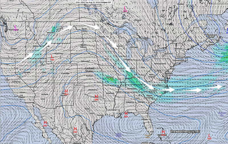
Here’s the mid level atmosphere late Tuesday afternoon—
18z GFS forecasst for Tuesday 5 PM. (500 mb 18 000 foot level) Tough will be sliding to our east while the hot air remains far south of us. (Click on image for a larger view.)
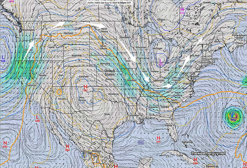
By next Saturday, a deep trough and associated low pressure will affect our weather—
18z GFS forecast for next Saturday 5 PM. (500 mb 18,000 foot level) Deep trough over the Ohio valley will spawn low pressure and rain. The next tropical system is visible in the Atlantic. The hot air will be over Texas, Colorado, etc. (Click on image for a larger view.)
The tropical system in the Atlantic should stay far east of us, unless the trough in the east greatly accentuates or tilts negative. The effects of the system may be rough surf at the shore.