
Update Sat @ 6:05 PM — Some bright spots occurred today, but none of the sunshine I had though might been possible.
The front expected to move through our region a bit later, between 8-10 PM tonight with gusty winds and briefly heavy rain.
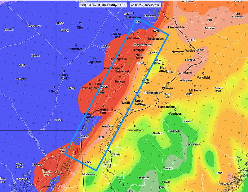
An overlap of high shear/high helicity is forecast by the HRRR in the blue boxed area around 9 PM. Fast moving, strong thunderstorms with high winds possible—
Sunday’s forecast looks good.
Update Sat @ 9:43 AM — Most models this morning maintain the low cloud cover. I still think there’s a chance of sun breaking through in the early afternoon.
This morning’s models have some areas of high shear and high helicity about 6 PM near Philadelphia. Some severe storms could develop at that time—

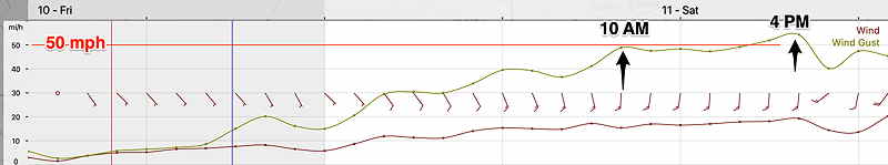
Wind gust forecasts have been reduced to about 40-45 mph instead of the 50 mph previously forecast.
Update Sat @ 8:22 AM — The new Canadian GEM model now predicts significant sunshine breaking through around 2 PM in areas from Norristown eastward. The cold front moves through 6-9 PM with showers and maybe some thunder. GUSTY WINDS this afternoon and with the frontal passage.
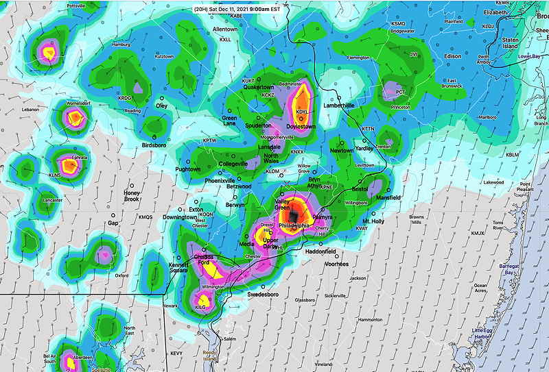
Update Fri @ 9:33 PM — Tonight’s early models have some changes: the heavy morning showers on Saturday, depicted in this afternoon’s HRRR rain graphic (below), now are forecast to move more north and west of the city. So it doesn’t look like the morning showers Saturday will be that heavy around the immediate PHL area.
Another change: the latest HIRESW-FV3 does have some bright spots and breaks of sunshine develop around noon and early afternoon. (mentioned below). If that occurs, expect the windy conditions to be somewhat more pronounced due to ” vertical mixing” of sun-warmed air with strong upper winds.
Initial Post Discussion—[post_published]
A warm front will move through the area Friday night into Saturday morning. Very mild air will move in behind the warm front. A very strong cold front moves through Saturday evening.
Saturday
Saturday’s forecast has changed somewhat since yesterday, especially with likely showers during the morning hours.
The warm front moves to our north about 6-8 AM. The latest HRRR shows some heavy shower activity about 6-9 AM in Philadelphia—
Most of the showers move to our northeast, but the HRRR and NAM-NEST are showing lingering widely scattered light showers/drizzle until late morning. (Earlier forecasts had the showers ending much earlier, then cloudy and windy.)
After the morning rain, most models keep us with low level clouds and very windy. I’ve seen situations where models incorrectly show little clearing following a warm front passage. So I while I would expect cloudy conditions, don’t be surprised if some sun breaks through during the afternoon.
It should be dry between noon and 6 PM.
High temperature 67.7º ± 2.3º (NBM Blue Bell)
It will become very WINDY, with most models having wind gusts of 40-50 mph, although the model blend (NBM) wind gusts are in the 35-40 mph range.
The front moves through between 7 PM and 9 PM Saturday evening with a quick burst of showers and high wind gusts.
Sunday
High pressure builds in for Sunday. Becoming mostly sunny and seasonably cold. Winds diminish. Breezy. High temperature 47.6º ± 1.1º (NBM Blue Bell)
Looking ahead… next week shows a large upper air ridge developing. Very mild weather likely.