WEEKEND WEATHER FORECAST

Sunday forecast updated Sun 8:46 AM, highlighted below

Saturday forecast updated Sat 7:15 AM, highlighted below

Update Friday 10:25 PM in highlight below

Update Friday 7:45 PM — The forecast below was based on Friday’s morning and early afternoon models. The models that have become available late in the afternoon suggest the possibility of a more cloudy, unsettled Saturday with some showers as early as 2 PM. I’ll update with tonight’s models that will become available between 9:30 and 10:30 PM.

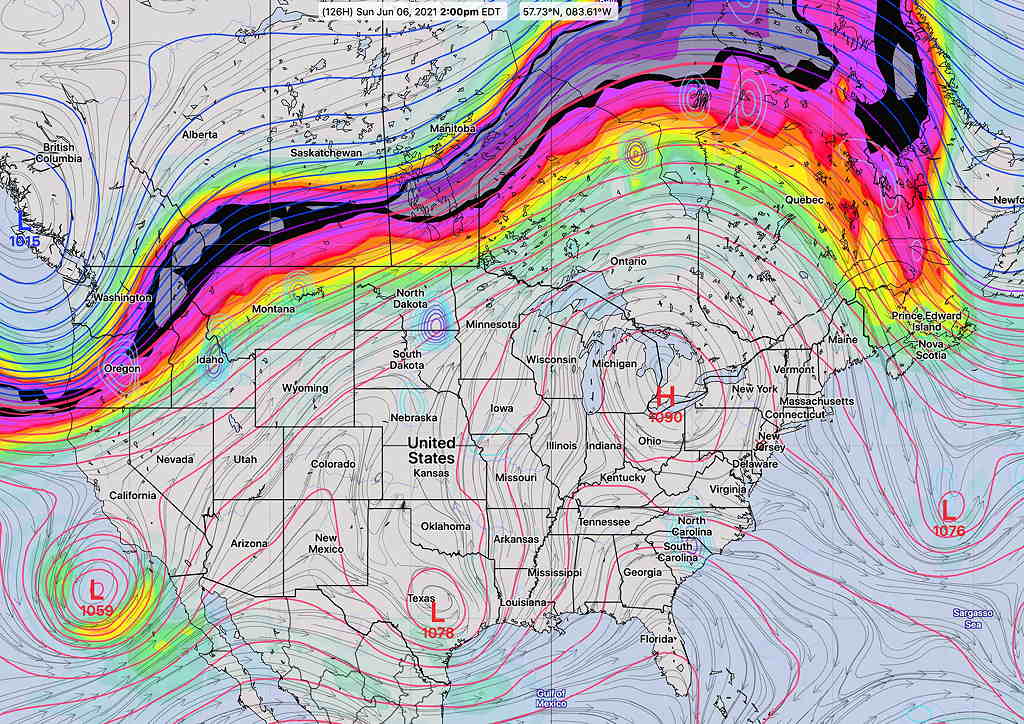
The cool, dry air mass that has given us four days of stellar weather will be moving off to the northeast, unfortunately just in time for this weekend.

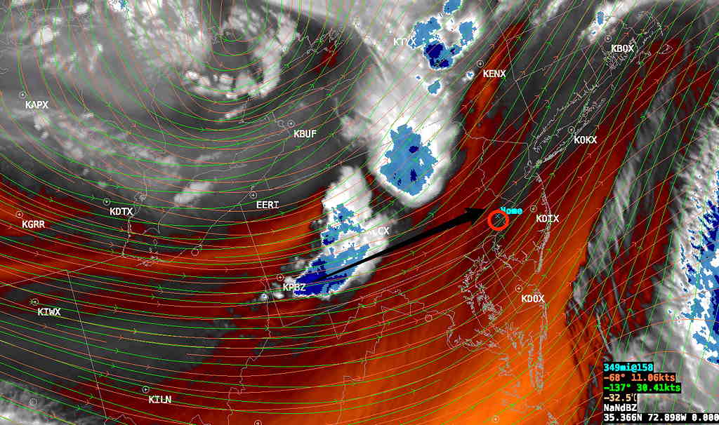
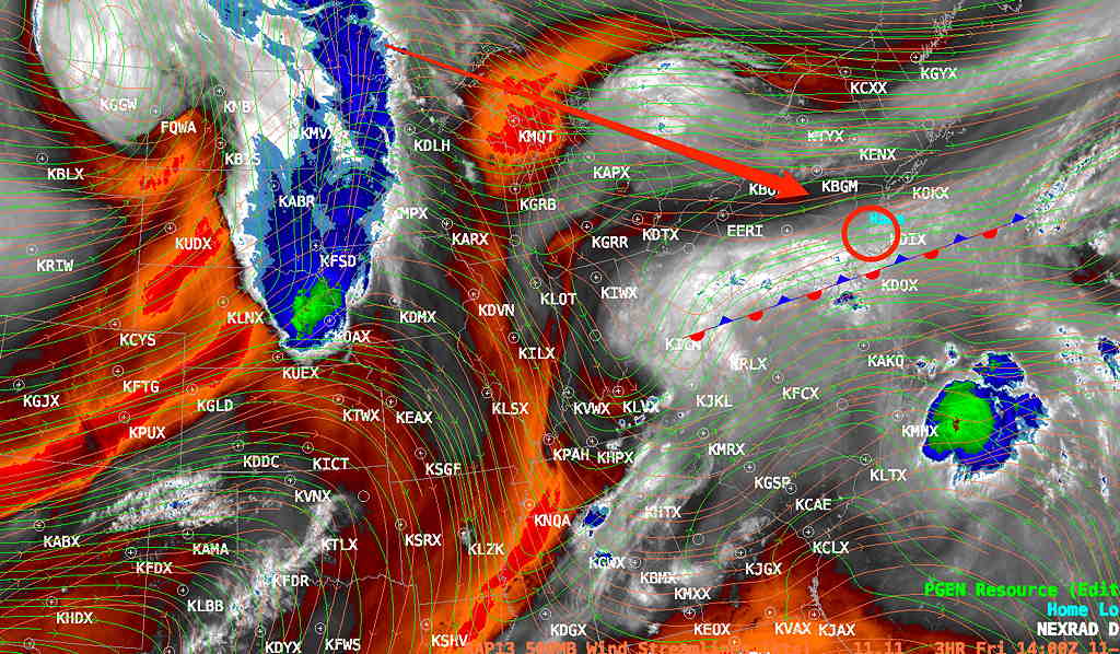
This weekend will be affected by several disturbances shown on Friday’s water vapor satellite image with a boundary becoming stationary just south of our area—

Current Weather Setup – Water Vapor Image at noon on Friday.  A series of disturbances (1, 2, 3) moving along a boundary between cooler air and warm air to the south will affect us over the next few days.   (4) shows a low pressure system that will bring a strong cold front next Tuesday. (5) is the tropical system that is expected to move to the Carolinas, south of us, but may introduce moisture our way.  (Click on image for a larger view.)


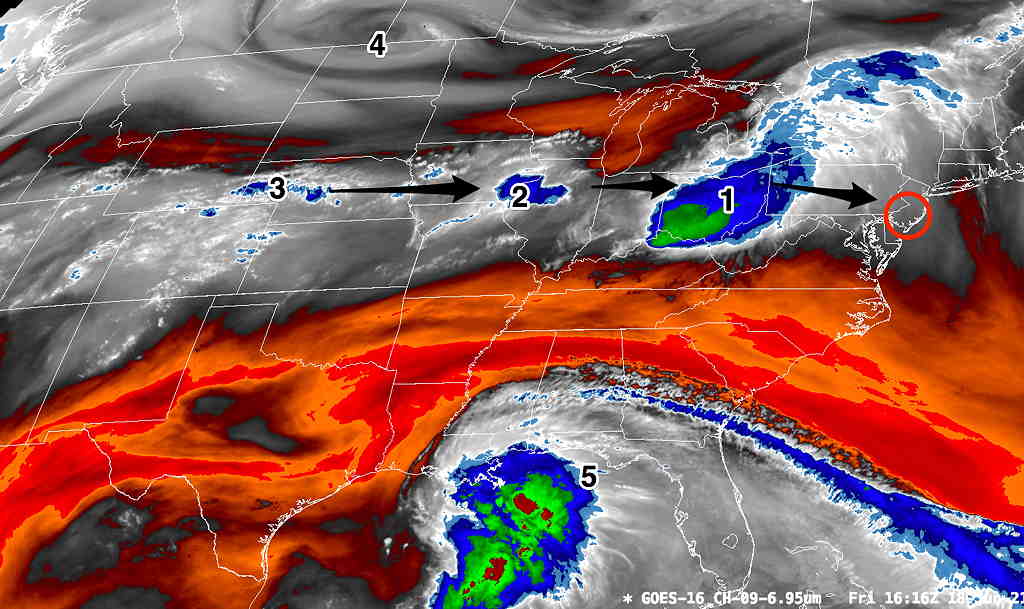
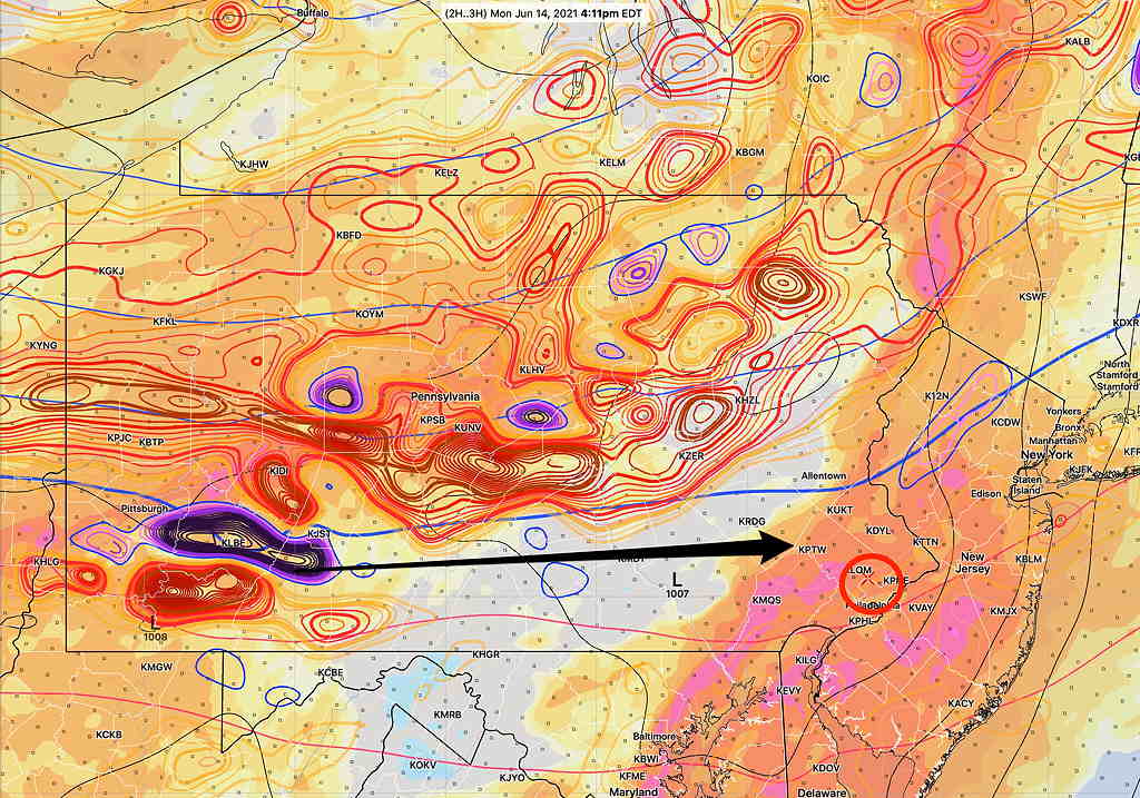
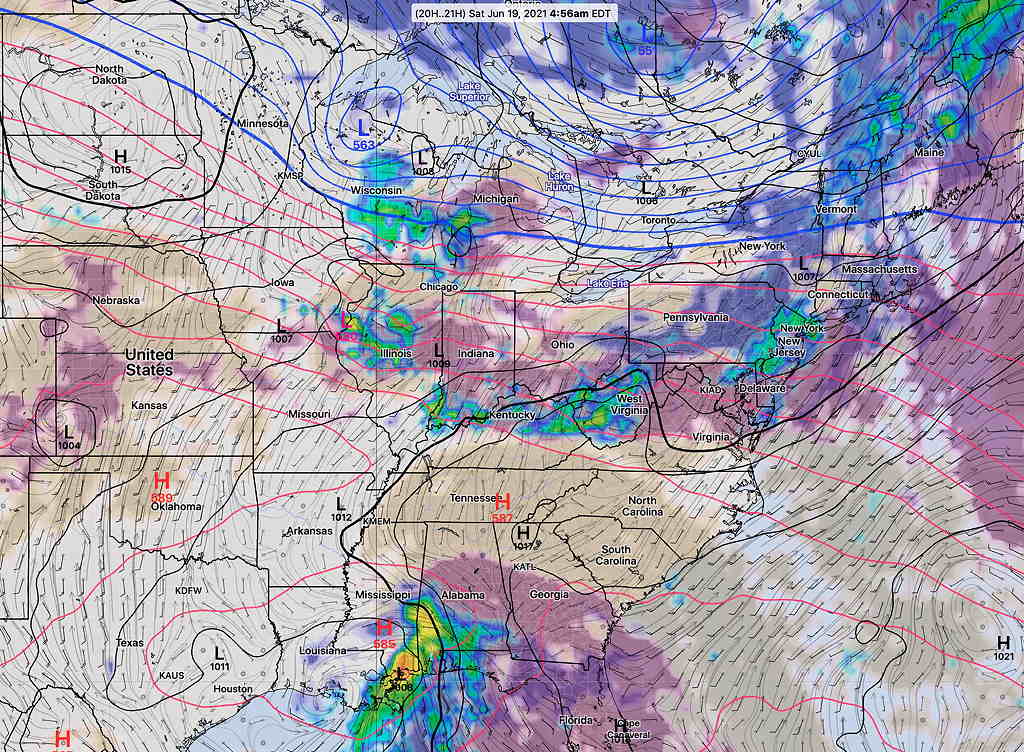
The first disturbance will move into our area about 3-5 AM Saturday morning with showers and (maybe thundershowers).  The GFS cloud/radar forecast is below—

GFS forecast 5 AM Saturday   (Click on image for a larger view.)

The showers move out around daybreak Saturday, and clouds break for hazy sunshine during the morning. It will be humid (dew points around 68º) and very warm. High 88.1º sd 2.2º (NBM Blue Bell, PA)

Areas of cloudiness re-develop during the afternoon.

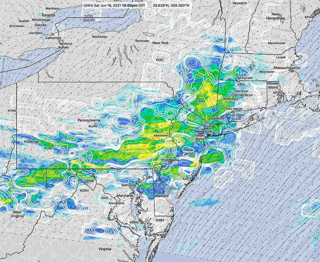
Additional showers and thunderstorms develop later afternoon on Saturday and especially Saturday evening. (Some models have thunderstorms developing as early as 2–5 PM mostly from the city on southward. Most hold off any showers until late afternoon or early evening. Some keep the activity both north and south of the immediate PHL area, so there’s some uncertainty how much rain the immediate PHL area and suburbs will receive. There remains higher than usual uncertainty regarding timing and areal coverage of the showers on Saturday. (Even the HIRESW-ARW2 and the HIRES-FV3 aren’t in agreement about the thunderstorms for Saturday afternoon.)

Saturday 7:15 AM update —There should be some hazy sunshine this morning. Several models from early this morning show showers/thunderstorms developing between 3 and 5 PM Saturday afternoon in the immediate PHL area.

The NBM paints a broad stroke with this rain Saturday evening— (Sat AM Update continues with this broad area of showers this evening.)—

NBM model 1 hour rain Saturday 10 PM (Click on image for a larger view.)

Mostly sunny, very warm and humid. High 89.5º sd 1.8º (NBM Blue Bell, PA) A chance of showers and thunderstorms in the evening, with highest probability south far north and west of the city. Any showers will be widely scattered and will occur between 5 and 11 PM, most likely around 7-9 PM.
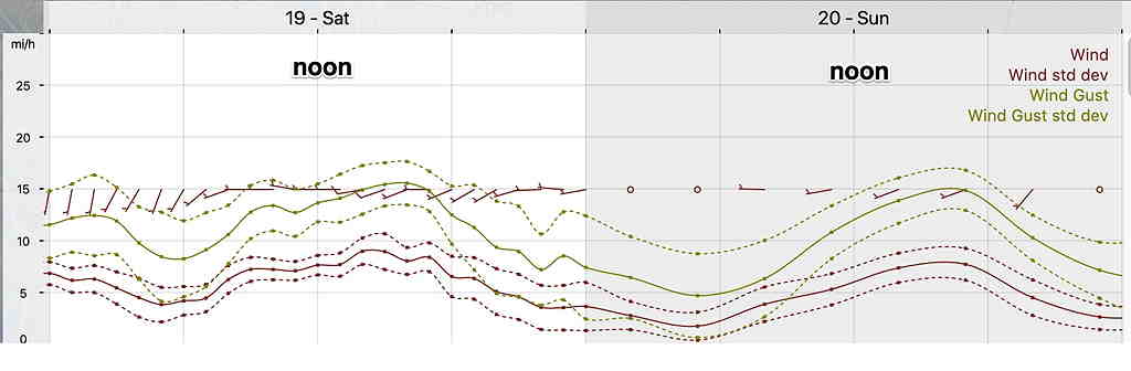
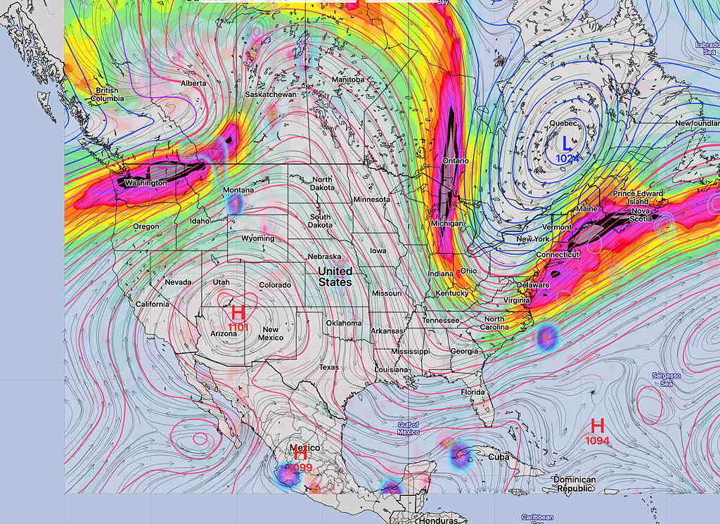
Winds
NBM Wind Meteogram Blue Bell PA

THUNDERSTORMS: MONDAY EVENING

Tue 05:27 PM Forecast Review — The thunderstorms developed just after 7:40 PM and were more severe than I would have guessed. (We had small hail here!)   

Update 6: 15 PM- This afternoon’s GFS has activity moving through earlier, possibly as early as 8 PM -10 PM

Mon 04:15 PM Update — Thunderstorms are looking more likely this evening and tonight. Some of them could be strong, especially to our west.  We’ve had plenty of sun to get things going.

This afternoon’s hourly HRRR (High Resolution Rapid Refresh) and RAP (RAPid Refresh) models show substantial increases in available convective energy (CAPE ~ 2400 j/Kg ) and thermodynamic instability (“Lifted Index”  -5ºK  to -7ºK, which is very unstable) for this evening.   Maximum Precipitable water values have increased as well to 1.7″ range. 

At 4 PM here’s the current satellite water vapor image showing disturbance east of Pittsburgh that will affect us in about 5-7 hours.

4 PM water vapor  (Click on image for a larger view.)

Not coincidentally, the HRRR shows a corresponding strong vorticity maximum/minimum couplet in the same spot—

HRRR vorticity (500 mb) and Lifted index at 4 PM  (Click on image for a larger view.)  This energy will affect our area by 10 PM to 2 AM


This upper air disturbance will affect us by 10 PM to 2 AM, although some models are showing the possibility of thunderstorms developing in western suburbs a few hours earlier.   

The weather model forecasts have not been too good over the past three days. On Friday, we had much more rain than predicted and on Saturday/Sunday, our area never received the areas of rain that many models had predicted.

We are more likely to see some thunderstorm activity this evening. The models are showing a distinct trough passing through between 6 and 8 PM this evening, yet there is quite a bit of model spread regarding the timing of the showers and thunderstorm. Many show the precipitation occurring behind the trough, anywhere from 5 PM to midnight!

If we continue to get some breaks of sunshine this afternoon, most models show potential energy (CAPE) and thermal instability levels that can produce strong thunderstorms. That said, the amount of precipitable water is not at the level seen with the heavy rains a week ago and it’s not all that clear that we’ll get enough sunshine to ignite strong storm development.

Strong storms a possibility from 5- midnight, but considering the model track record with the current pattern, we’ll have to see. If things clarify, I’ll update.

WEEKEND WEATHER FORECAST

Updated Fri 11:55 PM highlighted below
Updated Sunday Forecast highlighted below (Sat 7:35 PM)

Sun 10:09 AM Update — Today’s  (Sunday’s) forecast continues to be difficult to pin down. Early morning radar did not show the showers predicted by some of the models last night.  This morning’s latest HRRR, NBM, and RAP show some light very widely scattered sprinkles around the 2-4 PM time frame, but this is low confidence.  Most likely time for any rain is after 10 PM.  

I’ll start this forecast by pointing out that the areal coverage and quantity of rain on Friday far exceeded the amount rain forecast by the models 24 hours prior.  The overall weather pattern is undergoing a transition this weekend (as explained below), often leading to lower confidence forecasts.  Indeed, I started preparing this forecast Friday morning and there has already been a shift in the model forecast this afternoon.

This weekend will be affected by a gradual transition from last week’s weather ridge (hot weather) to a weather trough (cooler weather).

Last week—

250 mb Upper air forecast from  last weekend with jet stream far to our north


Next week—

GFS 250 mb wind forecast (jet) next Wednesday.  (Click on image for a larger view.)


The transition in the position of the jet has already started, with a stalled frontal system to our south and cooler temperatures.

As mentioned, the precipitation on Friday had already moved further north than had been forecast (even this morning’s HREF came up short while the GFS did better. ) —

Friday morning water vapor, showing position of stalled front. (Philadelphia area in red circle)  An upper air disturbance should move down and affect us Saturday afternoon. (red arrow) (Click on image for a larger view.)


There remain large differences in the weekend forecasts from this afternoon’s NOAA, Canadian and ICON models. 

I will base this on the model blend (NBM) and HREF, with the idea that these composite models have done the necessary comparisons and arrived at a more accurate forecast.  (Even the HREF and NBM do not closely agree on Sunday’s forecast.)

Lingering clouds with scattered sprinkles very early Saturday morning.

A mix of sun and clouds in late morning into the early afternoon.

Towards late afternoon, more clouds and a chance of scattered showers developing into the early evening, mainly north and west of the Philadelphia area. High 77.3º sd 4.1º

Early morning clouds and showers (HREF, Canadian GEM) or just early morning cloudiness (NBM) may break for some bright skies or partly sunny skies in the afternoon, especially east into southern NJ. More cloudiness further north and west of Philadelphia.

Above forecast still holds. The NBM now shows a chance of widely scattered light showers early Sunday morning. Then varying amounts of cloudiness, similar to the sky conditions today. Nicer in NJ. The front comes through about midnight with showers, possible thunderstorms.

(The Canadian GEM model is the most pessimistic about Sunday, consistently forecasting showers.) Fri late update: The HRESW has joined the GEM with clouds and showers Sunday.

A cold front moves through in the evening with showers/possible thunderstorms. The NBM keeps the rain to our west until after midnight (while the GFS shows showers about 8-10 PM) High 76º sd 4.0º (high spread, high uncertainty) High 79.6º sd 1.6