OK SATURDAY, NOT SO GREAT SUNDAY- FORECAST

Sat 08:21 AM Update — As for cloud cover today, what you see is what you get for most of the day. There may be some brighter spots in some areas around 2-3PM, but then lower clouds move in.
Fri 10:46 PM Update — Tonight’s NAM and NAM NEST are more aggressive with the heavier rain making it into Philadelphia on Sunday.  (They are the only models available now that extend into Sunday.) It looks like it will rain much of the day. Saturday’s forecast looks good.  

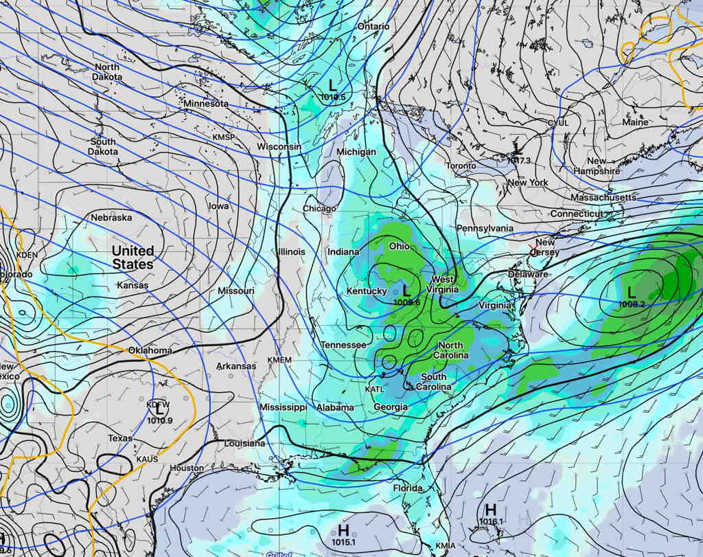
High pressure has pushed in Friday afternoon and the frontal boundary that has been stalled near us will be pushed to our south taking some of the humidity and showers with it.

The high pressure system will move off to the northeast.   A northeasterly flow of cooler air will be with us for the beginning of Saturday.  Unfortunately, the frontal boundary to our south will still be active and moisture and cloudiness will move in during the afternoon on Saturday as low pressure develops along that same boundary.

Saturday—

  • Some sun very early, then increasing high cloudiness.   Considerably cloudy 12-3 PM. Mostly cloudy after 3 PM.
  • High temp 84.2º sd 1.3º  Dew point comfortable- low 60s.
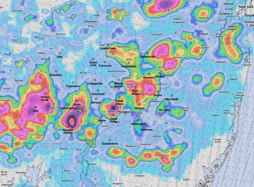
  • Some showers possible late evening.
  • Winds ENE 5-10 mph, gusty to 15 mph  in the afternoon.

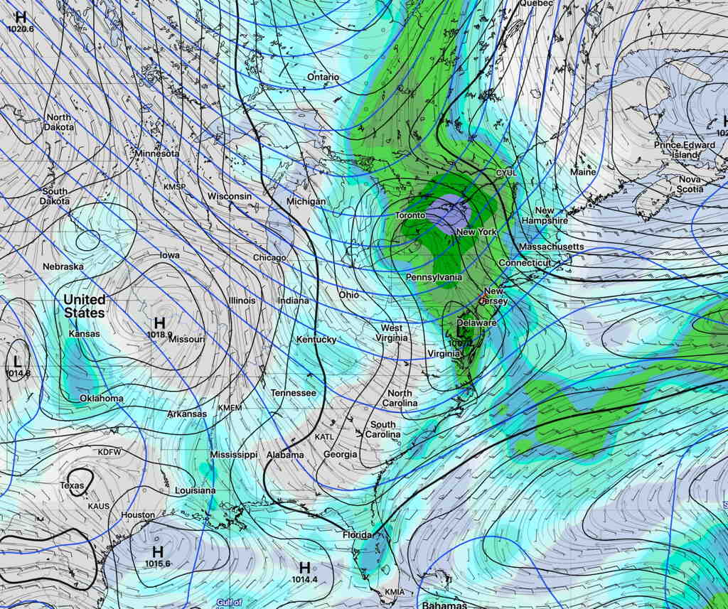
The frontal boundary and the low pressure wave brings rain and showers before daybreak  Sunday.   There is uncertainty about how much rain we will have on Sunday.  The latest GFS is faster with the onset and has the the main batch of rain exiting during the morning.  The model blend and most of the models have rain throughout much of Sunday. 

The model blend (NBM) tends to lag with big forecast changes, as it is based on models run 1-6 hours beforehand.  If there are major forecast changes as the GFS implies, the model blend won’t reflect it at this time. 

Sunday—

  • Cloudy with rain in the morning, possibly ending late morning.  Will need to update.  Cloudy in the afternoon.
  • High temp 75.5º sd 3.8º ( very high uncertainty/spread)
  • Winds ENE 5-10 mph and gusty to 16 mph.

I will do a quick update later this evening with the new model runs.

NOT THE BEST WEEKEND WEATHER OUTLOOK

Updated Thu 08:34 PM — Apparently, the huge difference in the weekend forecast is the result of a big difference in the European model and the our NOAA models.  It’s difficult to ignore our own models here.  So we’ll have to see how “beautiful” the weekend weather turns out to be.

I was watching the 6 PM news last evening and I heard the weather entertainer say it was going to be a “beautiful weekend”.   I said to myself,  ‘Gee, what is she talking about??’

An upper air trough and high pressure to our northeast will bring an easterly flow of cooler temperatures, but low pressure is expected to develop on the stalled boundary that is expected to sink to our south.

We will get some dryer air  on Saturday, but it’s not a sure thing how much sunshine we’ll see.  The statistical models, (the GEFS, SREF) along with the Model Blend (NBM) maintain a fair amount of cloudiness on Saturday.   Rain/showers are returning on Sunday.

Saturday  forecast SREF model—

Short Range Ensemble Forecast (SREF) for 2 PM Saturday (Click on image for a larger view.)

Sunday forecast GEFS model—

Global Ensemble Forecast System (GEFS)  for Sunday 4 PM (Click on image for a larger view.)

It’s still a bit in the future and things could change, but right now a beautiful weekend isn’t in the cards.

HEAVY RAIN WEDNESDAY

The rain developed about 1 PM and stayed mostly in Philadelphia and areas south.
Wed 07:32 AM Update — The rain last night did stay to our north. Last night’s models have backed off on the extreme rain totals for this afternoon. 0.75-1.5 inches looks to be the generalized amount later this afternoon.
Tues 10:44 PM Update — Tonight’s models just becoming available vary in the location of the first batch of rain tonight (maybe staying north of the immediate area) and tomorrow afternoon (which may be later in the afternoon or early evening and mostly from Philadelphia and to its south.) The models seem to vary with the location of the stalled front.
Heavy rains are expected Wednesday in the Philadelphia area.

A frontal system will stall near our area. Two separate rain events will move through.

The first disturbances will move in before daybreak, about 3-6 AM Wednesday morning with heavy rain.

Another disturbance will move through during the mid to late afternoon. The afternoon disturbance will bring the heaviest rains. 

High moisture levels (“PWAT” or “precipitable water”) along with strong dynamics and slow storm motion due to light winds will result in localized areas having 1-3+ inches of rain.

The latest Model Blend (NBM)  depicts the localized nature of the rains tomorrow.  (The locations shown with the heaviest rain should not be taken literally; almost every area will have some heavy downpours. )

NBM precip forecast for Wednesday 5 PM