Hurricane Dorian continues to confound forecasters as the forecast track and predicted intensity keeps changing.
Rather simplistically, I’ve hung my hat on one of a multitude of hurricane models, the COAMPS-TS, based on its low 24 hour error margin.
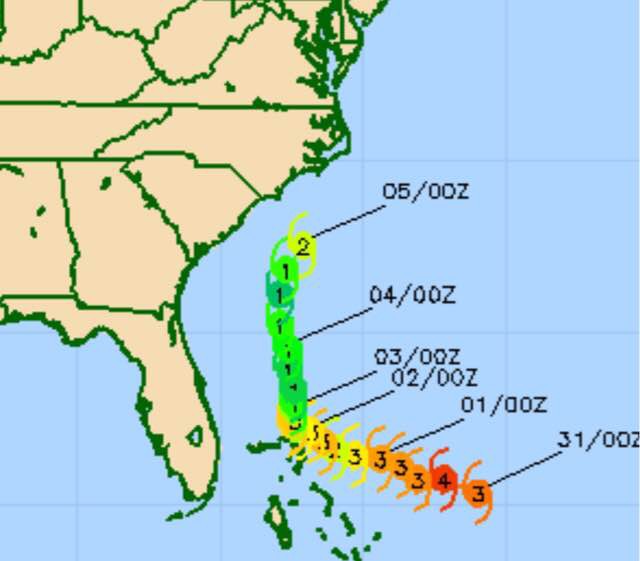
The latest COAMPS-TS just available has moved the track further westward again, closer to the track that it had forecast Thursday evening.
18z COAMPS-TS forecast for Dorian
We’ll have to see if the next runs of the GFS and ECMWF models move in the same direction.
As for our weather in Philadelphia, Sunday is looking better with a mix of periods of clouds and periods of sun, especially from Philadelphia and eastward. (The same strengthening of high pressure that will be giving us some sun tomorrow is likely the same feature that has moved Dorian’s forecast track to the west again.)
Sunday will be rain-free until evening here.
Clouds are expected to move in later Sunday. Scattered showers appear likely Sunday night and on Monday.
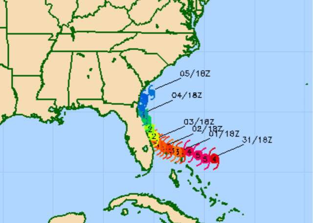
There has been a significant change in the likely track of Hurricane Dorian. The US Navy COAMPS-TS and the European ECMWF were the first to pick up on this changed track. The GFS has joined the pack with this likely change in track.
Here’s the current COAMPS-TS track and intensity forecast:
00z Navy COAMPS model forecast for Hurricane Dorian
(The COAMPS is known to have a northeasterly bias, so this track may be over-done slightly in northeasterly directional movement. )
The current likely landfall area, based on the latest GFS, is near the border of Georgia and South Carolina.
As for our Philadelphia weather, Saturday continues to look good with mostly sunny skies. Some cloudiness may sneak in late in the day.
Sunday is still looking mostly cloudy, with some sunny breaks possible. The models keep us dry in Philadelphia and east into NJ, however the models also show significant areas of vorticity (upper air disturbances) that may wring out showers. (Currently NOT shown by the models.)
Monday is currently looking like a mix of sun and clouds, more humid, still dry during the day. The models again appear to be ignoring the vorticities that often bring some scattered showers.
High pressure that brought the delightful weather on Friday will remain with us one more day. It will slowly move off to the northeast over the weekend, giving us an easterly wind flow by Sunday.
A low pressure system in the Midwest will be blocked by this high pressure (the same high blocking the northern movement of Hurricane Dorian), but some upper air disturbances will attempt to invade the retreating high pressure from the west on Sunday and Monday.
Saturday will be mostly sunny, with some occasional fair weather cloudiness. High will be near 80.
Some of the moisture and energy from the Midwest system will move in on Sunday.
On Sunday: Combined with a surface easterly wind flow, there will be considerable cloudiness on Sunday, perhaps with occasional sun, although I’m thinking full cloudiness is most likely. There is the chance that some widely scattered showers may develop, although most of the models keep us dry during the day, despite some disturbances moving through. High 79.
On Monday, the trend on Sunday continues with mostly cloudy skies and a higher chance of widely scattered showers. High 80.
As mentioned yesterday, Dorian may indirectly influence our weather this weekend with increased high level moisture from the storms outflows.
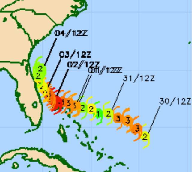
Speaking of Hurricane Dorian, a review of the latest model errors suggests that the newly developed Navy COAMPS-TS model is doing well with this storm. Interestingly, it was one of the first to show a trend of stalling off the Florida coastline and moving northward. The most recent GFS has begun to suggest the same general movement. The National Hurricane Center still has the storm hitting Florida, somewhat north of Palm Beach, on Tuesday.
Here is the latest Navy COAMPS-TS model prediction for track and strength of the storm—
US Navy COAMPS-TS model forecast for Dorian
Notice that it predicted the strengthening to a category 3 today, but it is predicting a subsequent weakening, then strengthening again before a delivering glancing blow off the central the Florida coast.