WEEKEND WEATHER FORECAST

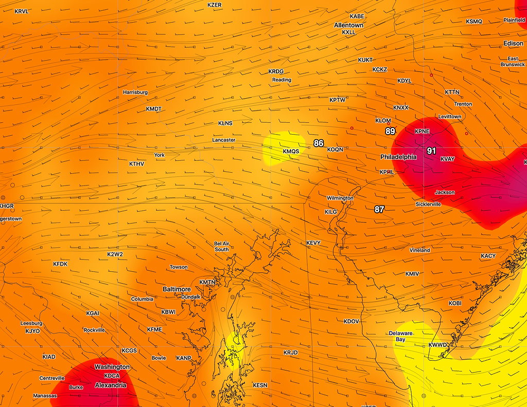
[su_note note_color=”#d9f2da”]Last night’s models moved today’s predicted high temperatures downward a degree or two and moved up the dew points a bit. High temp 87-89, dew points in the more uncomfortable mid 60s for Saturday.

EKDMOS Forecast High Temps

[/su_note]

From last night…

This weekend’s forecast is unusually straightforward and hasn’t changed appreciably from last night’s posted “outlook”.

High pressure will build in for Saturday and Sunday.  Sunny skies and above average temperatures expected.  Daytime highs near and above 90 in the city, a degree or so less in the northern and western suburbs.

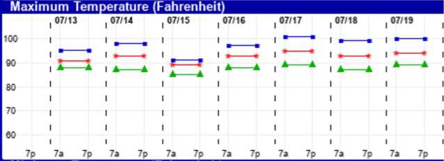
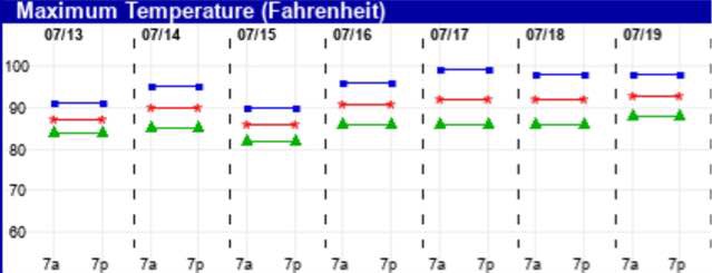
Here’s the latest EKDMOS high temperature probabilities for the coming several days for KPHL, Philadelphia Airport.

Ensemble Kernal Density Model Output Statistics (EKDMOS) High Temps

WEEKEND WEATHER OUTLOOK

A cold front will gradually move through later today (Thursday) and tonight.  It may be slow to move out Friday morning areas east of the city.

Showers and thunderstorms will accompany the frontal passage, indeed, they have already started around noon in some areas in the city.

[su_note note_color=”#d9f2da”]What’s interesting is that most (but not all) of last night’s models didn’t have showers moving through early and had delayed them until late afternoon or evening today.

Strangely, last night’s RAP model (RAPid Refresh) was the only model to show the early showers and thunderstorms we had today and this afternoon. Even last night’s HIREF was slow to move the showers in today.[/su_note]

High pressure will build in for Friday, Saturday and Sunday.  Sunny skies and somewhat above average temperatures expected.  Daytime highs about 90 in the city.

High Temperature forecast Saturday and Sunday (GFS Model) (about 3PM each day)

The track of Tropical Storm (or Hurricane) Barry is still uncertain.  It’s also unclear where all that tropical moisture will end up.

SUNDAY FORECAST UPDATE

[su_note note_color=”#d9f2da”]10:30 AM Sun Update: Both versions of today’s WRF show light, widely scattered showers Sunday mid to late afternoon. Largest coverage is south and west of the city. [/su_note]

Last night’s models were way off on the scattered showers and thunderstorms that developed late morning in the western suburbs and moved into Philadelphia. They were better with the second wave of storms that developed dynamically in place around 6pm and moved east. The third wave of storms about 8 pm were in a line that did lose, as predicted, a lot of its punch as it approached the city. Still, the timing was off.

This morning’s models didn’t do much better, although the HIREF did the best. Unfortunately, the HIREF didn’t become available until 11:38 am, long after I was out biking and dodging raindrops.

So what about Sunday?

The front is slowly moving through tonight and is expected to still be just south of the city on Sunday.  Considerable cloudiness for the morning and much of the afternoon,

One version of tonight’s WRF just available has clearing mid afternoon, one version has scattered light showers late afternoon from the city on south.   High 84-86 with lower humidity.