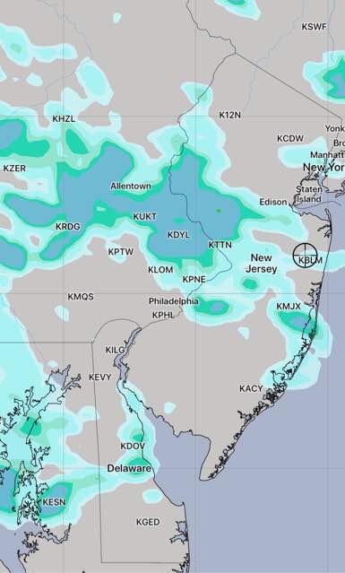
[su_box title=”Updated with Saturday 2 AM HIREF (Hi Resolution Ensemble Forecast) ” box_color=”#defcdc” title_color=”#000000″]The only significant change is that the high resolution ensemble forecast shows more widely scattered thunderstorms later in the afternoon and early evening on Saturday.
HIREF Forecast for 7:30 PM Saturday evening. (Shading=precipitation)
[/su_box]
from last night…
Most of my thoughts about this weekend’s weather can be found in my earlier post today.
Basically, an upper weak trough may cause some cloudiness Saturday afternoon possibly reducing the the achievable high temperature to the mid to upper 90s. It will still be very humid.
The most recent EKDMOS statistics (GFS model-based) still show a high of 100 for Philadelphia and the NAM and GFS MOS show a high of 98. Tonight’s WRF model versions show a range of 96-98.
[su_note note_color=”#d9f2da”]Tonight’s NAM again shows some clouds at times and even the chance of a widely scattered thunderstorm early Saturday afternoon.[/su_note]
A similar scenario is expected on Sunday with some afternoon clouds and some late thunderstorms more likely.
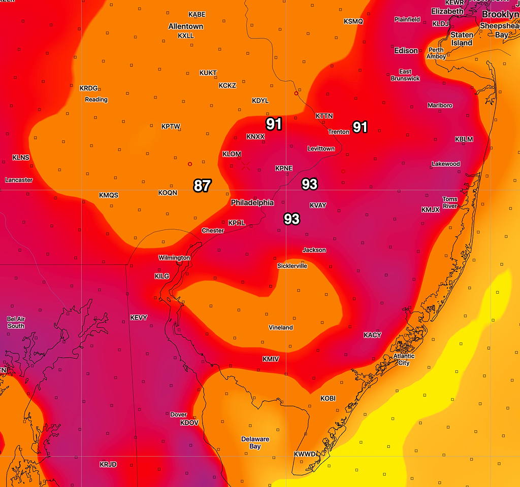
[su_box title=”Updated with Fri Afternoon’s NAM” box_color=”#defcdc” title_color=”#000000″]The NAM shows an upper air trough and some clouds Saturday afternoon, which will reduce the high temperatures reached, if correct. (This possibility was mentioned in my earlier forecast below.)
NAM forecast high temperatures for Saturday about 4 PM
[/su_box]
[su_box title=”Updated with latest GFS Model” box_color=”#defcdc” title_color=”#000000″]
New GFS Model (GFS, previously known as the FV3-GFS) Temps 3:45 PM Saturday
The latest GFS model is back to showing high temps above 100 in some areas.
[/su_box]
The heat wave for this weekend has been well-advertised with TV sensationalism approaching that of a major calamity.
That said, there likely won’t be record-breaking high temperatures and many (but not all) of the models have backed off slightly from their prediction of the high temperatures reaching 100 or more. Most of the recent models keep us in the 97-99 range.
Of course, with the TV outlets obfuscating the reporting of the expected heat index with expected temperature, it’s hard to know what to really expect. I heard on last’s night’s TV forecast that it will feel like “a rain forest” here due to high dew points. Keep in mind that the dew points in Miami are routinely 77-78 this time of year.
Ok, it will be very hot and very humid with hazy sunshine. High on Saturday 97-99. (I’m sure someone will find a thermometer where the temperature is 100 and above.)
[su_note note_color=”#d9f2da”]Did you know that the official temperature is measured 2 meters (about 6 feet) above ground inside a ventilated louvered white box of set dimensions on a grassy surface with no buildings in the immediate area. (World Meteorological Organization)
For Philadelphia, the official temperature is measured at the PHL airport. Who lives at the airport?
Having the Delaware river nearby, jet engine exhaust, and, up until recently, refineries, doesn’t seem to bother anyone in the record keeping department. [/su_note]
For Sunday, hazy sunshine and similar temperatures and humidity is expected.
[su_note note_color=”#d9f2da”]There are a few wrinkles of uncertainty with the forecast for Saturday and Sunday — weak frontal boundaries with embedded vorticities and some vertical motion will be approaching the area Saturday and Sunday.
The models show parameters that may result in some occasional cloudiness and even some widely scattered pop-up thunderstorms in the afternoon Saturday and especially Saturday evening. This may occur to our far west, but some may pop up here. Similar uncertainties exist for Sunday. Any clouds and showers that develop may reduce the high temperatures reached. [/su_note]