
#Phillywx #Philadelphia #weather #PAwx
Friday Update
Update Thu 11/23 9:38 PM — A weak cold front will move through mid day Friday with a few hours of mid and high level cloudiness.
Details for the weekend tomorrow. Currently, it appears that the showers will arrive Sunday evening between 6 and 8 PM. Initially, they’ll be quite light.
Possible Weekend Forecast Change
Updated Wed 11/22 @ 7:58 PM — The next few days are expected to be mostly sunny, but there’s been a shift in the forecast for Sunday.
Some background first:
Earlier this week, a coastal storm was expected to form in the Friday to Saturday time frame. Model runs by Tuesday had the storm moving out to sea, well to our south, not affecting our weather.
Today’s GEFS, NAEFS, ECMWF, ICON and GFS now have this coastal system moving up the coast late on Sunday and interacting with an approaching cold front late Sunday afternoon into evening, possibly during the Eagles game.
The timing varies, with the ECMWF having some rain moving in during the mid afternoon Sunday, while the GFS has the rain developing after 8 PM or so.
Here’s this morning’s ECMWF forecast for 7 PM—
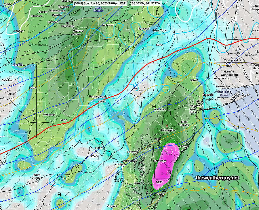
There are currently timing differences, with the GFS slower and later with the rain here. This system has been tough to nail down and I would expect further changes in the forecast.
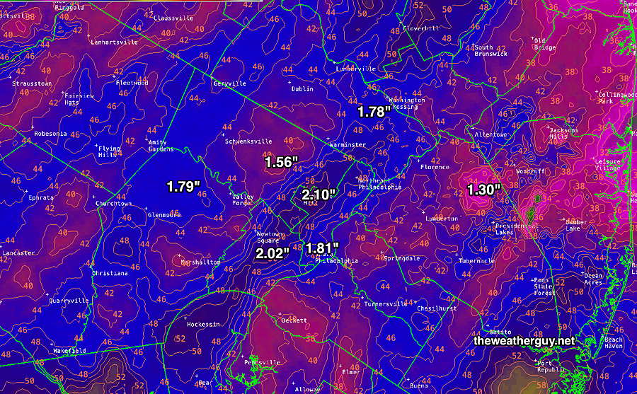
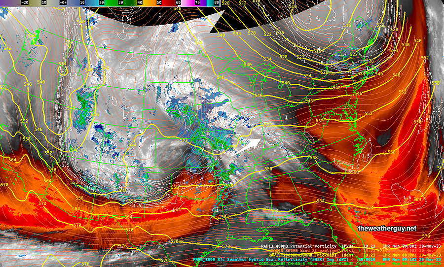
Here’s the MRMS total rainfall for the past 24 hours—
Here’s yesterday’s 12z RRFS—
As for Wednesday, several models continue with the idea of mostly cloudy, but a few breaks of sunshine can’t be ruled out. It will be mild. There’s the possibility of a few widely scattered sprinkles about 8 PM this evening.
Sunny for Thanksgiving Day and into the weekend. The trend is for lower temperatures here into the next week or so.
Wednesday Outlook
Updated Tue 11/21 @ 8:36 PM — The rain moved in on schedule and the heaviest rain is expected between 11 PM and 2 AM tonight. Winds are also expected to peak in the same time frame.
Here’s the current situation at 8:30 PM—

The rain ends about 4-5 AM Wednesday and skies will be cloudy early morning. There will likely be some brief periods of sunshine early to mid morning, but instability cloudiness will be with us for most of the day Wednesday. There’s even a slight chance of a widely scattered sprinkle.
It will be very mild! High 59º-61º, but somewhat windy.
Thanksgiving Day will be sunny, but cooler. high 51º-53º
Tuesday Rain Update
Updated Mon 11/20 @ 5:30 PM — We’re back to an earlier start of the rain on Tuesday, with the GFS, HRRR and NBM all shows rain moving in from the southwest, as early as 12:30 PM in Chester County and moving into the rest of our area after 1-2 PM.
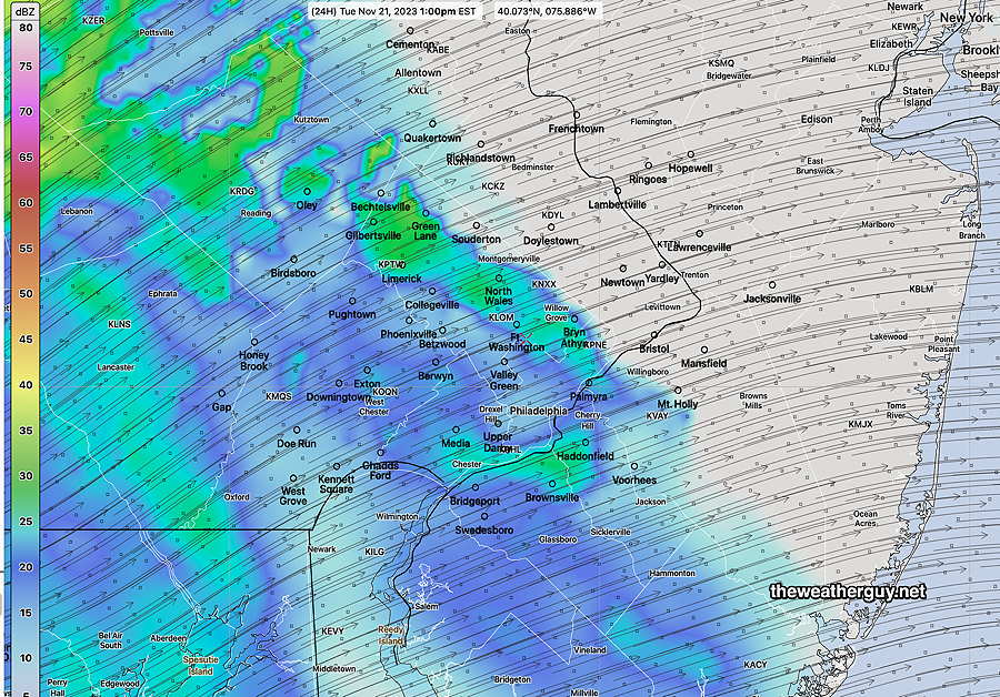
1 PM HRRR simulated radar forecast—
The latest HRRR cranks out some impressive rainfall and wind gusts later Tuesday approaching 40 mph —

It looks like the rain will end about daybreak Wednesday. We may see sunshine as early as 9-10 AM. but instability cloudiness will quickly move in with considerable cloudiness by afternoon.
Tuesday Rain Update
Updated Mon 11/20 @ 10:02 AM — There has been some uncertainty with the onset of the rain in Philadelphia on Tuesday. This morning’s trend is towards a somewhat later start, about 3-4 PM, earlier in southern Chester county. The latest 12z NBM (which tends to lag when showing changes) is still showing a 1-2 PM start.
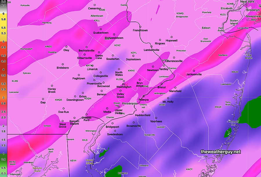
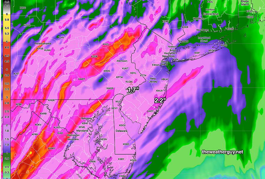
The total rainfall forecast based on this morning’s 12z HRRR—
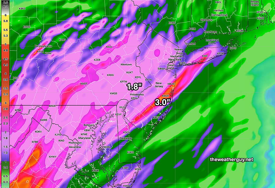
I’ve been playing with the still experimental RRFS and it shows similar totals, although placement is different—
The big story will be the WIND around midnight Tuesday into early Wednesday morning. Gusts are being forecast to 40 mph! Combined, with heavy rain, it will be an interesting 12 hours.
Previously Posted Sun 8:38 PM —
Low pressure is developing to our southwest and will move into our area Tuesday afternoon with rain. The rain may be heavy Tuesday night.
There has been some spread in the timing onset of the rain on Tuesday. Earlier forecasts were going with 4 PM. Recent models have some light rain as early as noon. Others delay the rain until 1-2 PM. The 1-2 PM start looks best at this time.
Rainfall totals are expected to be moderate to heavy with totals 1.6 +”. Here’s the latest NBM total accumulated rainfall forecast—

The heavy rainfall forecast has been consistently high. (We really need the rain!)
The speed of the system is still somewhat uncertain. The general consensus is that the rain ends Wednesday morning but clouds linger for much of the day. It will be quite windy.
Thursday, Thanksgiving Day, looks sunny but chilly. Highs upper 40s to low 50s.
There’s another chance of rain in the Friday through late Saturday time frame due to a coastal storm. Much uncertainty with the details right now.