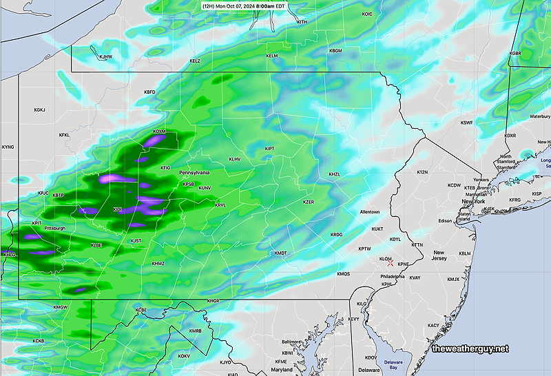
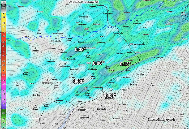
10-07-24 00z HRRR total rainfall for tonight. (Click on image for a larger view.)
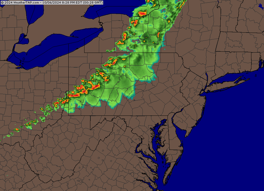
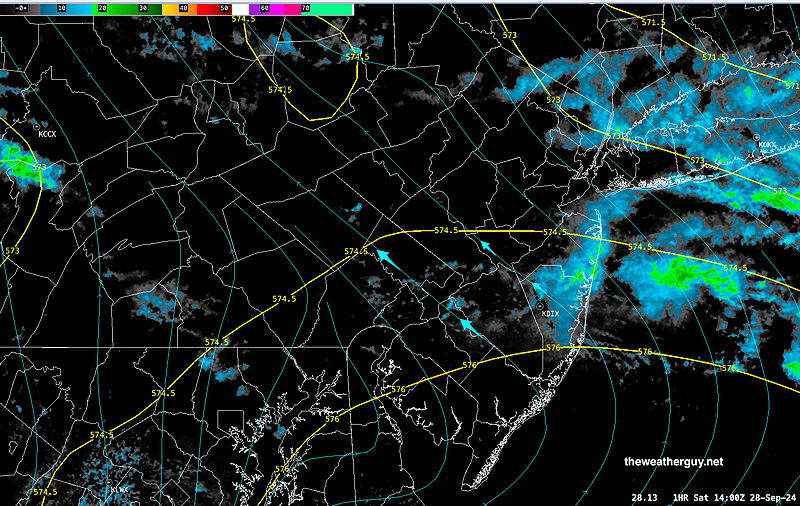
Every high resolution model has this line of storms falling apart by the time it gets to Philadelphia. I’m going with the models, not the radar. We’ll see what happens.
I often chuckle when the TV weather people too frequently use the expression “I’m tracking the storms”. Weather is dynamic, not a train. On this blog, I avoid that expression like the plague.
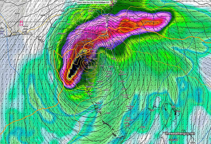
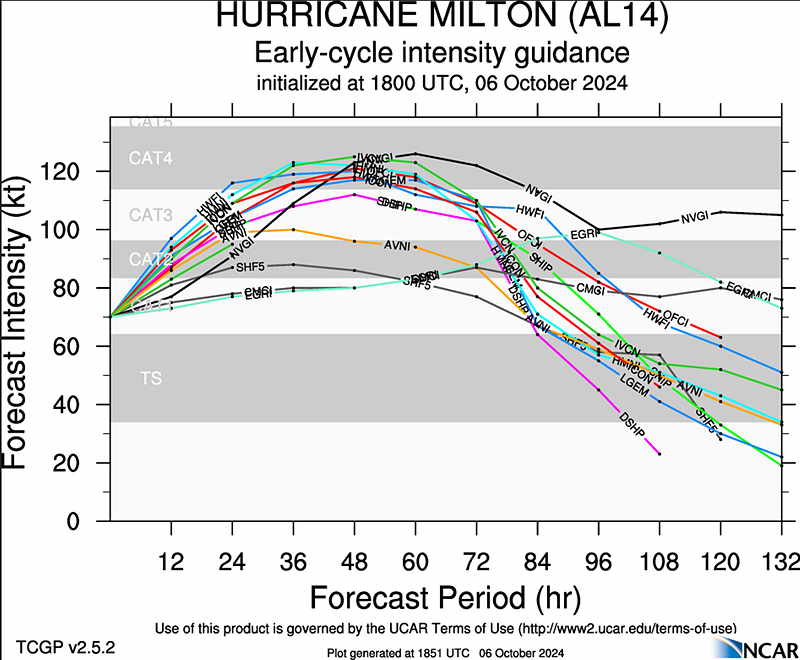
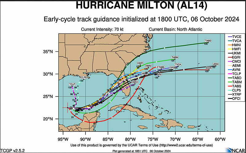
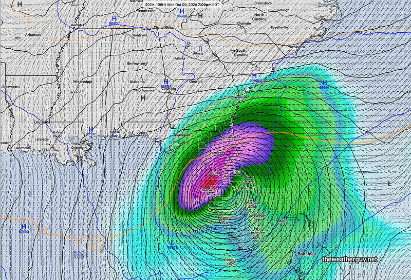
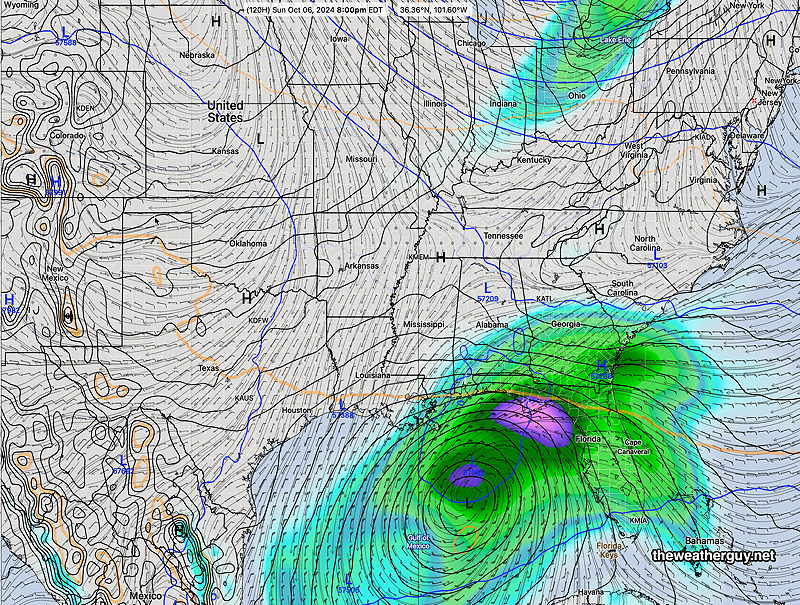
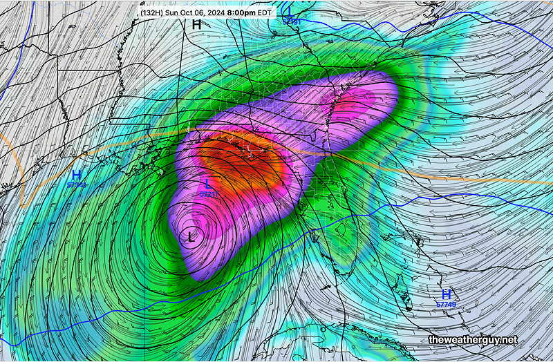
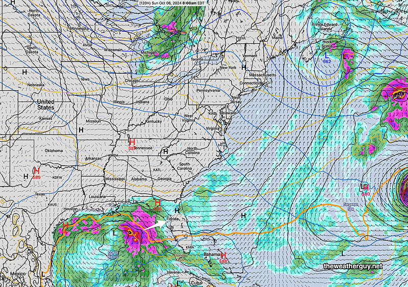
Hurricane Milton Update
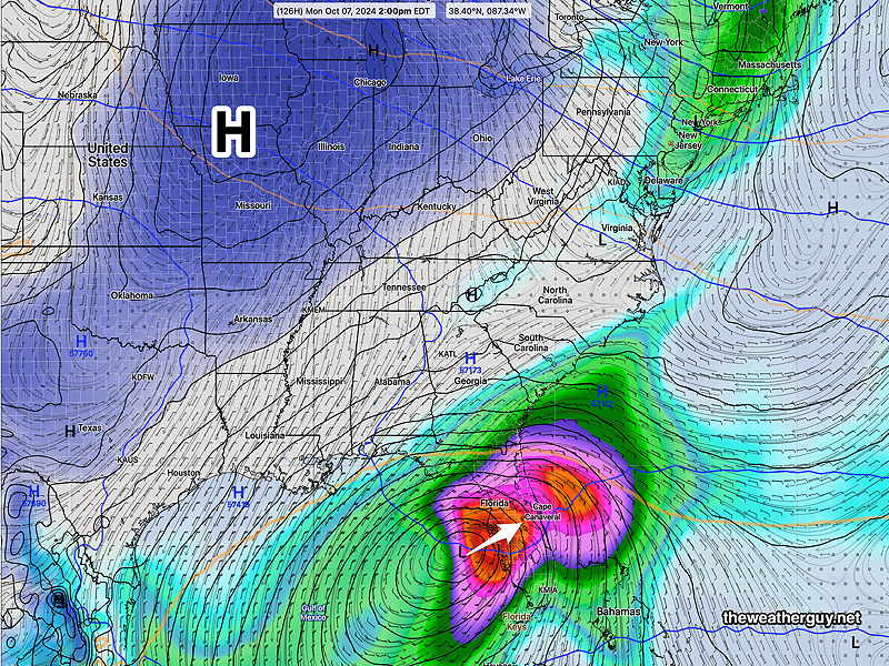
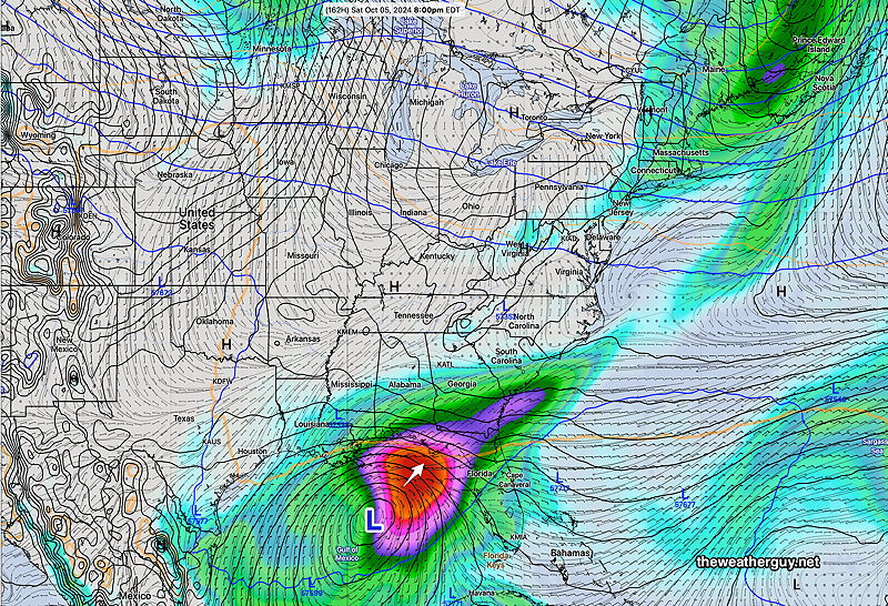
Posted Sunday 10/06/24 @ 3:14 PM —The latest model guidance is forecasting a major hurricane for the west coast of Florida. There is some question about the timing and exact point of landfall, but the intensity looks to be at least a Category 3 or likely a Category 4 storm.
The latest GFS has a northern track, further north than several other models—
Milton looks to be a fast moving but dangerous storm.
Sunday Forecast Update
Posted Sunday 10/06/24 @ 8:55 AM — While some of the lower resolution global models (GFS, ECMWF) still show a line of showers after midnight in our area from a cold front, the higher resolution models (HRRR, RRFS, NAM-NEST, HRDPS,) show very spotty rainfall with low or no rain accumulations in many areas.
Here’s the NAM-NEST forecast total rainfall —
10-06-24 0tz NAM=NEST total rainfall Sunday night (Click on image for a larger view.)
Here’s the HRRR total rainfall forecast for tonight—
10-06-24 06z HRRR forecast rainfall for tonight (Click on image for a larger view.)
Either way, not much in the way of rainfall. The reasons are discussed below.
Hurricane Milton
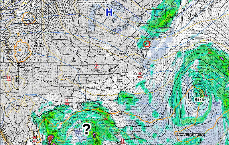
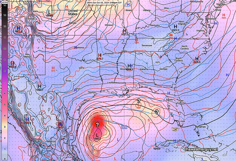
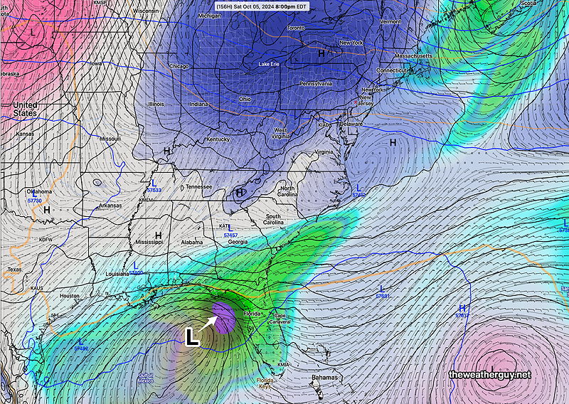
Posted Saturday 10/05/24 @ 7:55 PM — A new tropical system has developed in the Gulf, likely to intensify and be named Hurricane Milton.
Those following this blog know that the ECMWF-AIFS has been forecasting this development and track for days. While I hadn’t posted the German ICON model, it too was an early forecaster of this system.
The several runs of the GFS have jumped on board with a forecast track that would affect areas recently hurt by Hurricane Helene.
Here’s the latest GFS with a central pressure of 954 mb, likely at least a Category 2 , possibly Category 3 storm —
Today’s 18z run of the GFS. Forecast time is 7 PM Wednesday Central pressure 954 mb (Click on image for a larger view.)
The latest German ICON is further south and slower —
Today’s 18z German ICON model forecast for 7 PM Wednesday. (Click on image for a larger view.)
This morning’s ECMWF is a bit further south (as is the Canadian Global) with this storm—
Todays 12z ECMWF forecast for 7 PM Wednesday. Central pressure 969 millibars. (Click on image for a larger view.)
The model that has been forecasting this for almost a week, the artificial intelligence/machine learning model has a track further south and a bit faster with landfall—
Todays’ 12 ECMWF-AIFS forecast for 7 PM Wednesday (Click on image for a larger view.)
Hurricane Tracks often change and I expect changes in these model forecasts. But a strong system to affect parts of Florida looks high probability.
Update Sat 10/05 5:38 PM — Watching the Phillies game and “doing the weather”. The latest models do show a hurricane at least Category 2 moving into central Florida from the western Gulf. More details after the game
Originally Posted Sat @ 12:27 PM — —Beautiful weather for this weekend. The chance of rain has significantly diminished for our area for Sunday night.
Why are we not getting any rain?
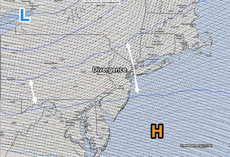
People have asked why we’re not getting rain. The reason is a persistent lower and upper level high pressure system, that both blocks the rainfall and results in downward vertical motion in our area.
More importantly, this persistent high pressure has caused the jet stream to be to our north, resulting in upper level downward motion unfavorable for rain in our area. My conjecture is the global warming has caused the resulting warmer air mass to be larger resulting in a more northern jet flow, along with a smaller air mass of colder air to our north.
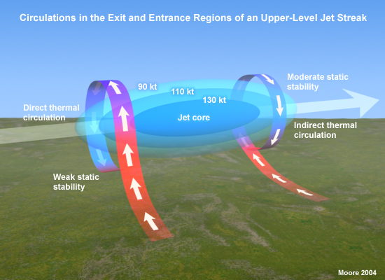
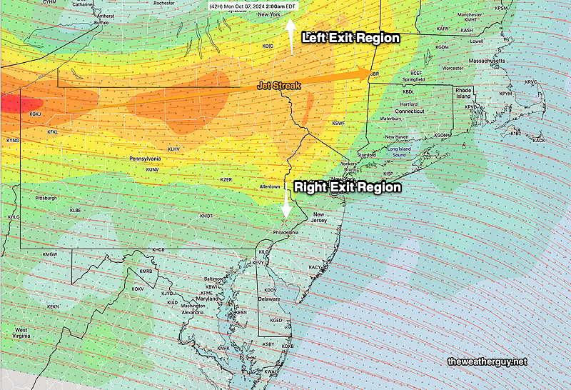
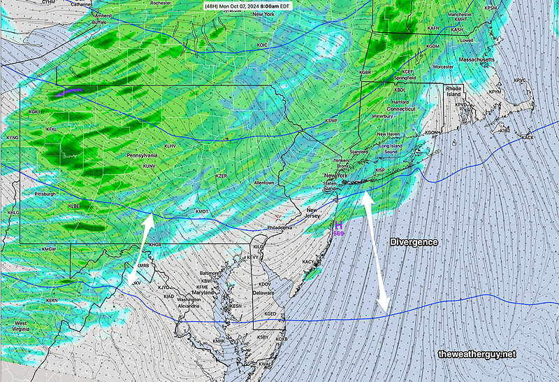
As a result, we’re in the in an area of both upper air divergence and the we’re also in the “right exit region” of the jet streak.
Here’s the latest HRRR. Notice the increasing divergence of heights of the 500 mb winds resulting in downward motion and diminishing chance of rain in our area. (Click on image for a larger view.)
Additionally, we’re located south of the jet streak, specifically in the right exit region, also resulting in downward motion unfavorable for rain in our area—
The right exit region has downward motionThe right exit region 2 AM Monday morning. Downward motion in our area. The terms entrance and exit regions are very confusing and not intuitive. (Click on image for a larger view.)
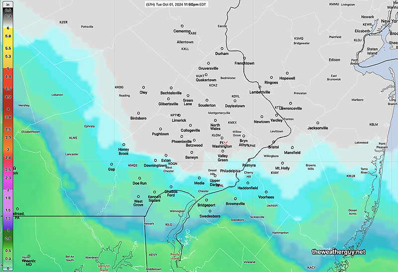
Here’s the HRRR predicted total rainfall for Sunday night. The upper level divergence and position of the exit regions affect our rainfall —
Total rainfall expected Sunday night into Monday. Little to no rain again for us! (Click on image for a larger view.)
I’ll be updating this page about the the likely hurricane to affect Florida later today. (It appears the AI model of the ECMWF has been the first to identify the likely storm. I should note that the German ICON model has been forecasting something similar for several days. )
Folks, I’m recovering today from a routine surgical procedure today, Friday. I hope to be back online tomorrow.
Friday through Sunday
Posted Thursday 10/03/24 @ 3:25 PM — Some cloudiness expected Friday morning, then sunny mid-day. Clouds move in again during the afternoon ahead of a cold front.
The showers associated with the cold front pass through Saturday morning, before daybreak. Most areas will see little in the way of rainfall. Currently the RRFS shows some rain, mostly in Chester county, but that may change.
A mostly sunny weekend expected. Another front moves through late Sunday night into Monday morning with a somewhat greater chance of some rain here.
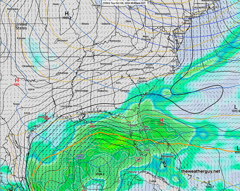
Regarding the tropical system in the Gulf of Mexico, the models are all showing it to remain weak, possibly only a tropical storm, with central pressures of about 1000mb (Helene was in the 955mb range. Average sea level pressure is 1013.8 mb) . Plenty of rainfall is expected in central Florida with this system and there will likely be a problem with flooding, as rain is expected for several days.
Despite the consistent ECMWF-AIFS forecast shown several times earlier this week, most models have a weak system with two or more centers. One of these centers will move across Florida and eastward while the other center might hang back, again blocked by high pressure to the north.
NAEFS forecast for Tuesday at 8 AM. Plenty of heavy rain for Florida. Huge high pressure to its north will block movement towards us. (Click on image for a larger view.)
Thursday through Saturday
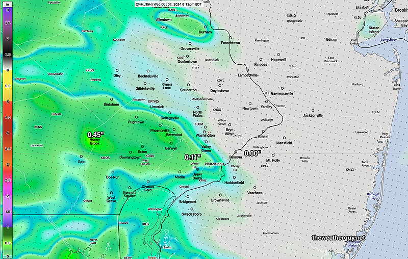
Posted Wednesday 10/02/24 @ 5:18 PM — High pressure builds in for Thursday and Friday. Mostly sunny skies Thursday and Friday morning. Clouds move in Friday afternoon ahead of a cold front. This cold front will move through Friday night into Saturday morning with the possibility of light showers Saturday morning, especially areas northwest of the city.
GFS forecast for Saturday at 8 AM. Cold front moving through in our area with some light showers. High pressure builds in behind this front, blocking the northeast movement of Hurricane Kirk and impeding the movement and intensification of the tropical system (?) trying to develop in the Gulf of Mexico. (Click on image for a larger view.)
The deterministic and ensemble models are still not convinced of a hurricane in the Gulf. Some tropical system will bring heavy rain into Florida is currently all that’s forecast.
The artificial intelligence/machine learning model of the ECMWF continues to have a hurricane develop by Monday afternoon—
10-02-24 12z ECMWF-AIFS forecast for 2 PM Monday afternoon. This model has been extremely consistent with this forecast and was the first to consistently forecast the eventual coastal landfall of Helene. This will be a good test of this model, since it’s having only partial support from the regular models. (Click on image for a larger view.)
Notice that blocking high pressure (blue shading above) will force any storm to an easterly track. The above also shows some showers early Monday for our area as another cold front moves through.
Wednesday Update
Posted Wednesday 10/02/24 @ 9:14 AM — Last night’s models have backed off on the showers reaching Philadelphia today. It now appears that they won’t make it into the western suburbs of Chester/Montco/Bucks either.
Regarding the potential storm in the Gulf of Mexico, the ECMWF-AIFS and the German ICON model continue to forecast a hurricane to develop around the Sunday time frame, while the statistical ensemble models show multiple low pressure centers and less distinct development. The ECMWF is leaning towards development and the GFS somewhat less so. The Canadian Global shows hurricane development but northward movement from the Gulf is blocked by high pressure in the US.
00z 10-02-24 ECMWF-AIFS forecast for Sunday at 5 PM (Click on image for a larger view.)
For illustration purposes, the statistical (ensemble) version of the ICON, the ICON-EPS, captures the uncertainty of several other models—
10-02-24 00z ICON-EPS forecast for Saturday at 2 PM Shading scale is increasing uncertainty in surface pressure, expressed as standard deviation. The red contours are minimum pressures, the blue are maximum pressures. (Click on image for a larger view.)
So still quite a range of forecasts.
Gulf Tropical Storm Update
Posted Tuesday, 10/01/24 @ 8:10 PM— Just a brief update. Today’s later models are increasingly forecasting another tropical storm or hurricane to develop in the same area as Helene with a current likely track taking it into northern Florida. Time frame varies as early as Sunday or early next week. The AI version of the ECMWF did surprisingly well with Helene and it shows much more defined development than previous runs.
ECMWF-AIFS forecast for Sunday at 8 PM (Click on image for larger view.)
Wednesday’s Weakening Cold Front
Posted Tuesday 10/01/24 @ 4:02 PM —As expected, the rain stayed to our west and south today. A cold front approaches on Wednesday, but this front falls apart as it approaches Philadelphia.
Most models show some shower activity in the afternoon (2 PM-4 PM) with the rainfall tapering off as it approaches Philadelphia.
The experimental REFS is the most impressive regarding our western sections receiving rainfall—
10-01-24 12z Experimental REFS forecast total rainfall by 6 PM Wednesday evening. Other models show more spotty showers and less rainfall. (Click on image for a larger view.)
It looks like Chester, and to some extent Delaware county, will receive the most rainfall. Other models keep the ‘heavier’ rain west in Lancaster county with even lighter totals closer to the city.
As for the next tropical storm in the Gulf, the models continue to show limited development and intensification. The low pressure system may linger in the Gulf longer. It’s definitely a different scenario than Helene so far.
12z ECMWF forecast for Sunday (Click on image for a larger view.)
Tuesday Forecast Update
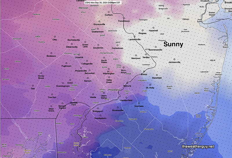
Posted Monday 09/30/24 @ 6:11 PM — High pressure to our northeast is forecast to block any rain from getting close to Philadelphia and its immediate suburbs on Tuesday. While the ECMWF and Canadian RGEM have some showers near Philadelphia, I’m going with the high resolution models along with the latest GFS which keep Philadelphia and most of the surrounding areas cloudy but dry.
Monday Update
Posted Monday 09/30/24 @ 10:13 AM — We had some bright spots and even some sun about 8 AM, but the latest models have backed off on the sunny breaks this afternoon, keeping any clearing further north and eastward—
09-30-24 06z REFS cloud cover at 3 PM Monday. (Click on image for a larger view.)
The latest NAM-NEST is still optimistic about some sun here this afternoon, but not the latest HRRR.
So, I’m leaning towards continued cloudy conditions, but we may be pleasantly surprised regarding a few bright skies and sun, especially north and east of the city.
Our “rainfall” on Tuesday has been reduced to perhaps a few isolated spits at most. Our relatively dry pattern continues.
Originally Posted Sun @ 5:33 PM — —This coming week’s weather will be a gradual improvement in conditions. with several systems to affect us.
Monday– High pressure builds in from the northeast, allowing partial clearing in the afternoon and maybe some sun, especially north of the city.
Here’s the REFS (experimental) cloud cover for Monday at 2 PM—
09-29-24 12 REFS (Blue=low clouds, maroon=mid-level clouds, tan = high cirrus clouds) (Click on image for a larger view.)
Tuesday– Remnants of Helene and upper low induce a surface low off the coast of Virginia. Blocking high pressure in the northeast will significantly reduce any rainfall in the immediate Philadelphia area. We’ll probably just see clouds and any light rain will fall in southern Chester and Delaware counties and Cape May County NJ.
Here’s the NBM (model blend) rainfall forecast for Tuesday—
09-29-24 18z NBM keeps the rain to our south on Tuesday. (Click on image for a larger view.)
Wednesday– Cold front moves through with most of the rain and dynamics moving off to the north of our area.
High pressure and another cold front moves in sometime Thursday into Friday.
The models are forecasting another tropical system in the Gulf for next weekend, but vertical wind shear may reduce degree of intensification.
09-29-24 12z ECMWF-AIFS forecast for Saturday 8 PM. Tropical system in Gulf (Click on image for a larger view.)
Today’s models are forecasting a less impressive storm, but that could change. Too early to know.
Posted Sunday 09/29/24 @ 10:31 AM — Through 9 AM Sunday, the MRMS rainfall totals for the previous 72 hours—
MRMS rain-gauge measured rainfall combined with rain-gauge calibrated and interpolated radar-based summary of ACTUAL RAINFALL RECEIVED. Color shading is in inches. Line contour numbers are in mm. (25.4 mm= 1 inch) (Click on image for a larger view.)
Not much additional rain expected through Tuesday, except in areas shown below.
Sunday Update – Week Forecast Outlook
Posted Sunday 09/29/24 @ 9:55 AM — Humid tropical air in our area overrunning high pressure to our northeast will continue to bring low level clouds, mist and the chance of light drizzle or light rain today, Sunday. Total rainfall looks to be less than Saturday. Northeast wind flow will keep us near 70º.
A break in the action with even some sun possible during the afternoon Monday, especially areas Philadelphia and northeastward, as high pressure builds down.
Low pressure developing along the Virginia coastline had been expected to bring us a decent rainfall Tuesday, but there’s been a consistent trend towards this low being too far to our south, suppressed by blocking high pressure. So very little rain now expected for Tuesday—
09-29-24 06z GFS Total rainfall by Wednesday morning. (Click on image for a larger view.)
A cold front moves through Wednesday. Little additional rainfall here.
Incredibly, the extended range models are strongly hinting at another tropical storm or hurricane in the Gulf next weekend, with a track similar to Helene. The machine learning/AI model ECMWF-AIFS has also been consistently showing a storm forming by next Saturday—
09-29-24 06z ECMWF-AIFS forecast for next Saturday at 8 PM. (Click on image for a larger view.)
Continued Cloudy with Varying Light Showers
Posted Saturday 09/28/24 @ 10:12 AM — Last nights 06z models and this morning’s 12z models continue to forecast low clouds and intermittent light showers through Saturday. Some models show some thinning of clouds in southern Delaware and Chester counties towards evening, but that reverses itself overnight.
There isn’t much change for Sunday according to the RRFS and REFS experimental models.
Here’s the current setup Saturday morning with light showers from very moist southeasterly flow—
Composite Radar at 10 AM with boundary level winds (low level) from the SE (blue contours) and1000-500 mb thickness (yellow contours) (Click on image for a larger view.)
While some models continue with a more substantial rainfall for Tuesday, the GFS is suggesting a further southeasterly development of low pressure which would have the heavier rain miss us. Too soon to tell.
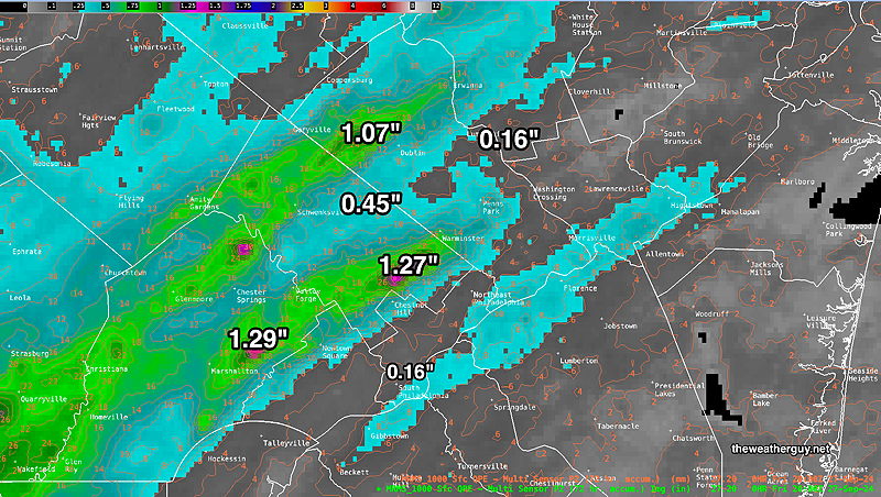
Total Rainfall So Far
Posted Friday 09/27/24 @ 5:44 PM — We need the rain. How much rain have we gotten over the recent days? Here’s the MRMS totals through 4 PM today.
MRMS rain-gauge measured rainfall combined with rain-gauge calibrated and interpolated radar-based summary of ACTUAL RAINFALL RECEIVED. Color shading is in inches. Line contour numbers are in mm. (25.4 mm= 1 inch) (Click on image for a larger view.)
Quite a range of values over our region!
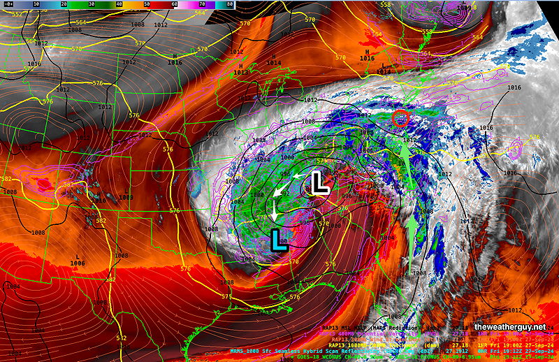
Originally Posted Fri @ 5:01 PM — —The remnants of Hurricane Helene continue to rotate into and merge with an upper air low over Tennessee.
Considerable moisture is being flung up towards Philadelphia from the south and southeast around this combined system and as it hits a high pressure ridge just northeast of us, the moisture is riding up over it and condensing out as rain.
Friday afternoon satellite water vapor image with superimposed RAP model 500-1000 mb thickness lines (yellow), Mean Sea Level Pressure isobars (black contours) potential vorticity (fine violet contours) with superimposed MRMS RADAR. Low pressure at the surface will rotate and merge with upper level low (blue L) Moisture on east side will rotate into our area . (Click on image for a larger view.)
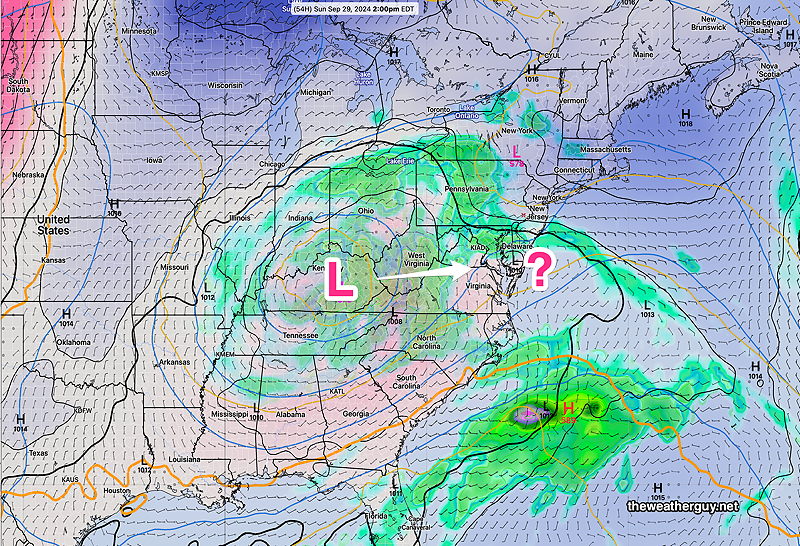
By Sunday afternoon, the upper low will have remained almost stationary, but will begin to move eastward and perhaps induce a surface low off the coast for Tuesday—
09-27-24 12z GFS forecast for Sunday at 2 PM. Secondary coastal low possible by Tuesday. (Click on image for a larger view.)
Saturday Forecast
Low clouds. areas of fog possible early, with showers likely throughout the day, widespread in the morning, more scattered and light in the afternoon.
NBM high temperatures: Blue Bell 73º Philadelphia 76º Above Average Uncertainty (based on standard deviation): ± 2.4º
Sunday Forecast
Low clouds, fog, some sprinkles early, then cloudy in the afternoon but little in the way of additional showers.
NBM high temperatures: Blue Bell, 69º Philadelphia 71 º Above Average Uncertainty (based on standard deviation): ± 2.7º
A break in the rain on Monday, widespread rain likely on Tuesday.