WEEKEND WEATHER FORECAST

Sat 11:27 AM Update —  Yet another update.  I knew this forecast was going to be a tough one.  This morning’s HIRESW mode shows these heavy showers that have developed  here late morning, although the model has them arriving about 1 PM.  So it’s going to be difficult to time the showers today.  The Canadian HRDPS didn’t show showers to occur at this time.  More showers, clouds and sun seems to be what’s in store.  
Sat 08:29 AM Update — It’s going to be difficult to time the showers today.  Most of last night’s models (NBM, NAM NEST) didn’t get it right so far this morning. The exception was the high resolution Canadian HRDPS, which matches closely to the showers occurring this morning.   So, continuing with the HRDPS for the forecast, there should be a pause in the showers by late morning or early afternoon.  The early afternoon should continue to be mostly cloudy.  Some more showers possible about 4 PM.

CMC-HRDPS High Resolution model forecast for 8 AM Saturday. Clouds and Precip Rate.  (Click on image for a larger view.)


From last night…

While I post the weather forecasts mostly for storms and weekends, I do look at the models every day.  It’s my daily crossword puzzle. This weekend’s weather forecast has undergone a significant evolution over the past several days.

Originally, Saturday was expected to be dry. Over the past two days, the forecast for Saturday has changed. There’s still some uncertainty about the amount of showers and the degree of cloudiness.

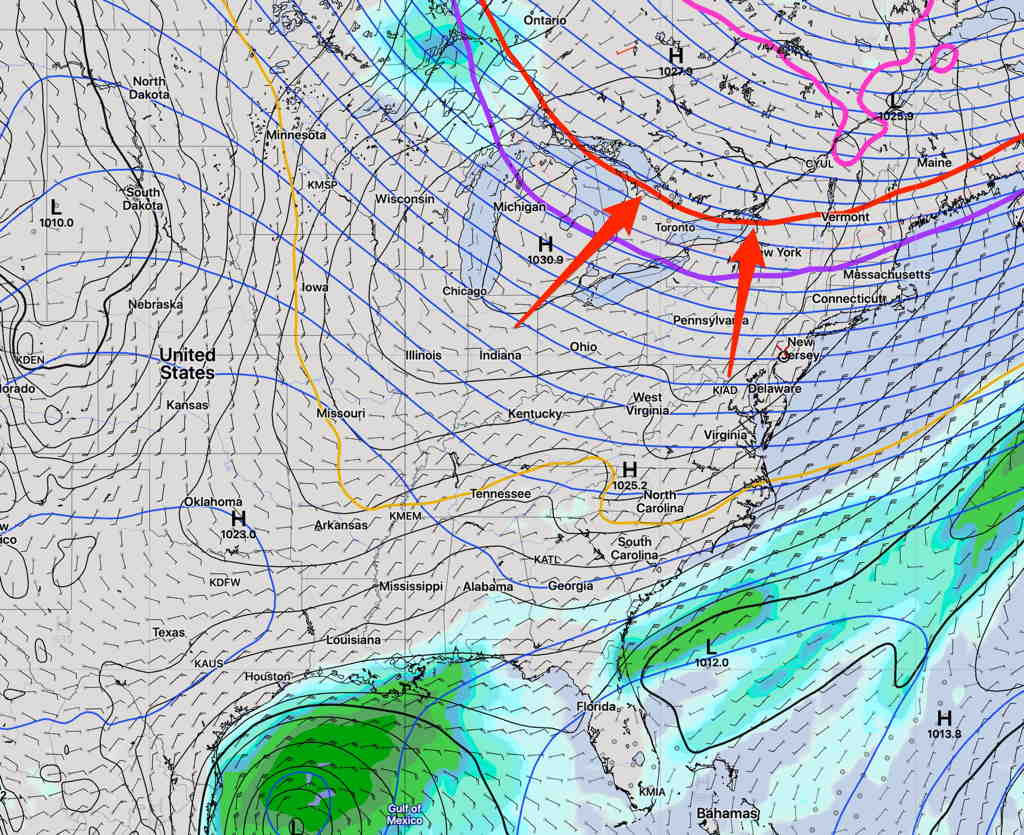
An upper air short wave will move through on Saturday along with a warm front.   Moisture from the south along with the short wave’s vertical lift will result in showers.

GEFS (new model version) forecast for Saturday 2 PM.  The dip in the 500 mb  heights (blue lines) represents the ‘short wave’.

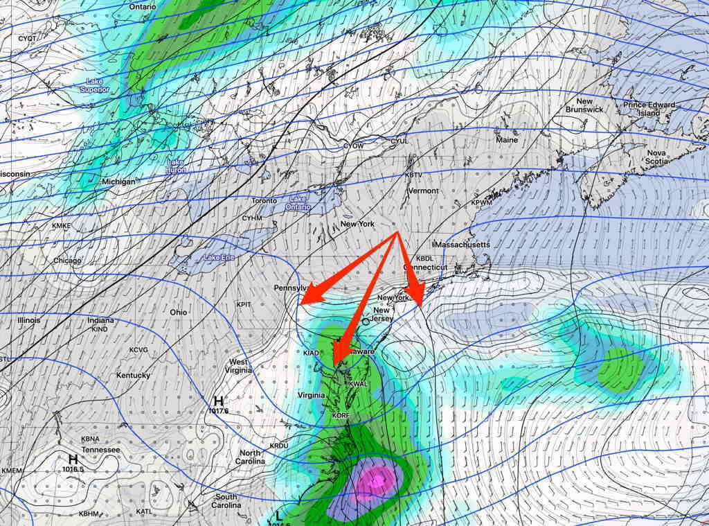
Tonight’s HRRR and HIRESW, just available, suggest even less rain and periods of clouds and some sun for Saturday
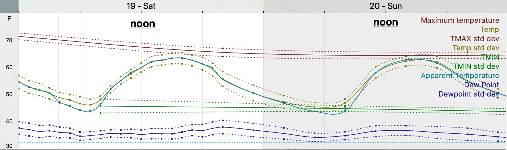
Saturday—

  • A mix of clouds and some sun.  Light showers possible throughout the day, although it’s looking less showery. Total precip 0.1 to 0.3 inches of rain.  Showers more likely far western suburbs.
  • High temp 74.6º sd 2.6º (high spread)
  • Winds light SE

Sunday—

  • Cloudy in the morning, sun by afternoon
  • No precip expected, although probabilities a bit elevated west of Philadelphia.
  • High temp 80.1º sd 1.1º   Humid!
  • Winds light SSE to S

WEEKEND WEATHER FORECAST

Another quiet weekend coming up weather wise.  A well-advertised dip in the jet stream will bring us unseasonably cool weather this weekend. This is easily seen on the Short Range Ensemble Forecast (SREF) model—

SREF Forecast Saturday 3PM  (Note the 540 thickness line [red] and a tropical disturbance in the Guif.  (Click on image for a larger view.)
Notice the red “540 thickness line” which is often used to forecast the approximate rain-snow dividing line in winter.  It’s not common that we see that drop into the northeastern US in September.

Average high temps are around 74º this week, but we’ll have high temps 63.8º Saturday and 64.1º (Model Blend version 4 mean high Temp.)

Sunny both Saturday and Sunday and low dew points!

NBM Temp/Dewpoints for Blue Bell PA  (Click on image for a larger view.)

Winds will be a bit gusty in the early afternoon both Saturday and Sunday.

The tropical disturbance in the Gulf of Mexico appears to be blocked from moving north, but there may be more development.


On the weather front, new models are becoming available in the next two weeks.  A final version 4.0 of the National Blend of Models  (NBM) is expected to be released as well as a new version of the GEFS, the Global Ensemble Forecast System.

A new version of the HRRR (High Resolution Rapid Update) model is hoped to be released next month, as well as a new RAP model (Rapid Update). (Previously planned for release in June, these new models were crashing when modeling severe storms. It was back to the drawing boards for these models)

A new version of the GFS model is gradually moving towards release by the end of the year or in January.

These new models should enhance weather forecasts, especially snow forecasts for the winter.  Say what you want about weather forecasts, these NOAA scientists are amazing.

Weather… and Other Things 'Up in the Air'