WEEKEND WEATHER AND FORECAST TREND

Forecast Updated Sat 08:50 PM —

For Sunday, the upper air low pressure system moves off to our east.  The pressure gradient will cause it to be windy. An upper air wave approaches late in the day  Still above average temperatures for January.  (Seasonal average high is 40º and low is 23º  Blue Bell.)

Sunday —

• Sunny in the morning, clouds move in towards noon.
• High temperature 44.0  sd 1.1º  (NBM model) Blue Bell.

• Windy late morning and early afternoon  WSW 12-15  mph with gusts to 20- 25 mph

Sat 08:46 AM Update — All models last night showed a several hour “dry slot” of clear skies this morning about 10 AM. (In past weeks, the recently updated HRRR v 4 has been particularly good at cloud cover forecasts)—
HRRR forecast for 10 AM today from last night’s model run (00z) (Click on image for a larger view.)


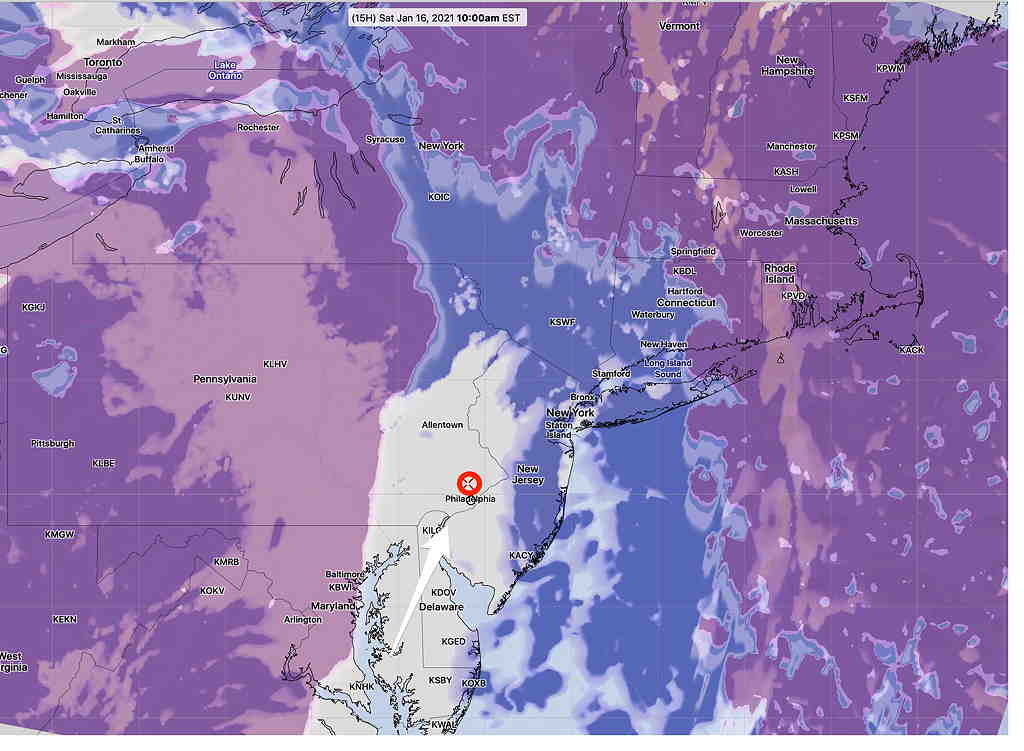
This morning’s 12z (7 AM)  HRRR (High Resolution Rapid Refresh) model has reduced this area of clearing to a narrow area moving through about 10 AM—

HRRR model from 7 AM this morning (12z) showing narrow area of clearing. (Click on image for a larger view.)

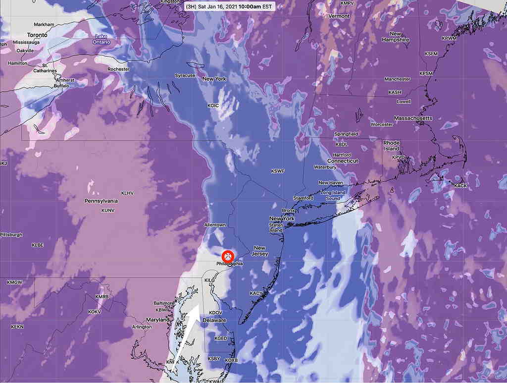
I guess we’ll see if we get the brief clearing predicted. Cloud cover is one of the toughest weather parameters to get right.


Fri 9:10 PM- Updated Saturday and Sunday forecast below
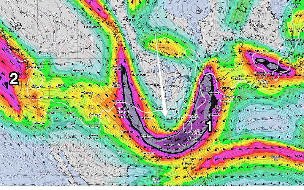
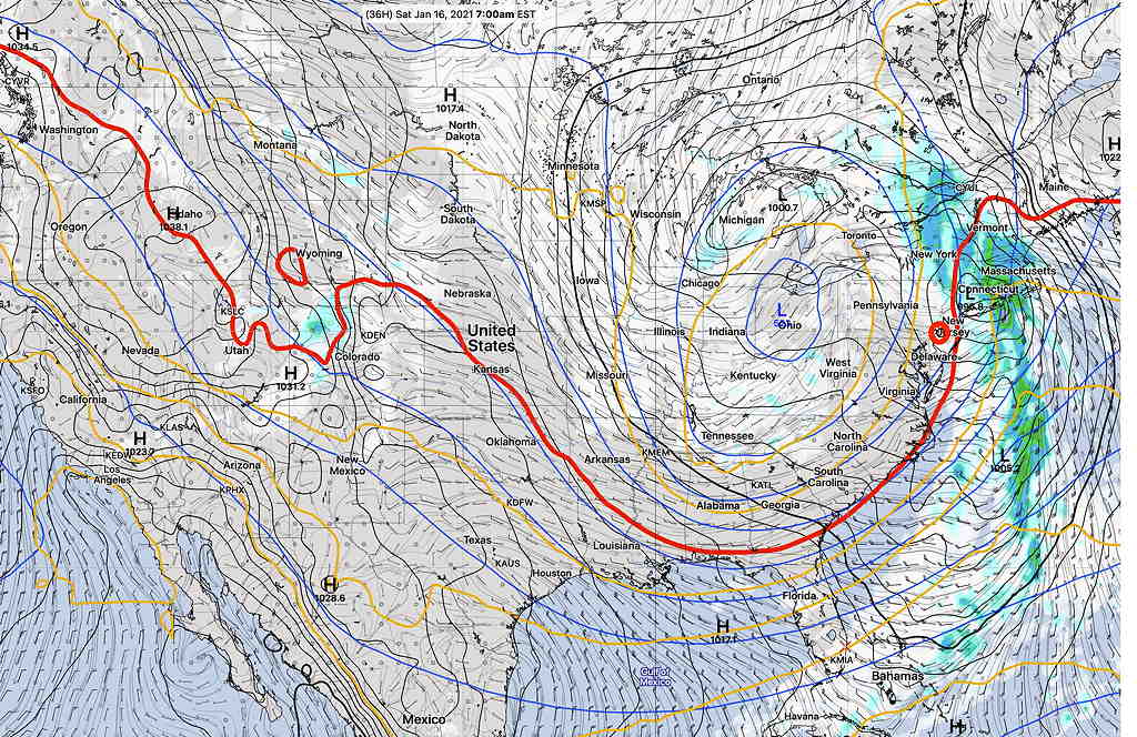
What had been thought would be a persistent pattern change starting this weekend is turning out to be a just a temporary dip in the jet flow this weekend;  a return to non-eventful weather is expected for much of next week.

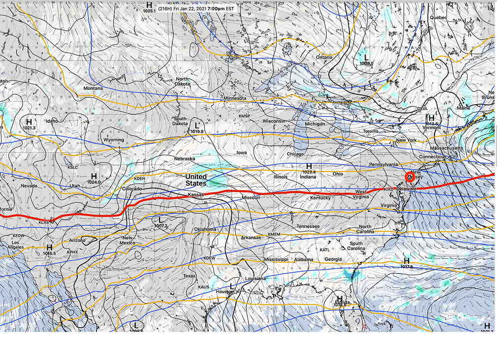
Regarding the dip in the jet flow this weekend, it’s best captured by the 1000-500mb “540 thickness line”  (RED),  which demarcates a colder, dense air mass from a milder air mass (often a dividing line for rain-snow)—

Canadian Global (GDPS) model surface forecast Saturday 7 AM showing 540 thickness line, upper atmosphere low pressure over Great Lakes and departing surface low pressure in the Northeast.  (Click on image for a larger view.)

Saturday —
• Showers end around daybreak.
• A few hours of sun early, then considerable cloudiness much of the afternoon.
• Widely scattered light sprinkles possible late afternoon or evening. Possible snow flurry mixes in.
• High temperature 46.4 sd 1.5º early in the day, then slowly falling temps  in the afternoon (NBM model) Blue Bell.
• Breezy, winds WSW 9 mph with some gusts to 15 mph

For Sunday, the upper air low pressure system moves off to our east.  The pressure gradient will cause it to be windy. An upper air wave approaches during the afternoon.  Still above average temperatures for January.  (Seasonal average high is 40º and low is 23º  Blue Bell.)

Sunday —
• Mostly sunny in the morning, cloudy in the afternoon.
• High temperature 45.1º sd 1.0º (NBM model) Blue Bell.
• WINDY,  WSW 12-15  mph with gusts to 25 mph mid-day.

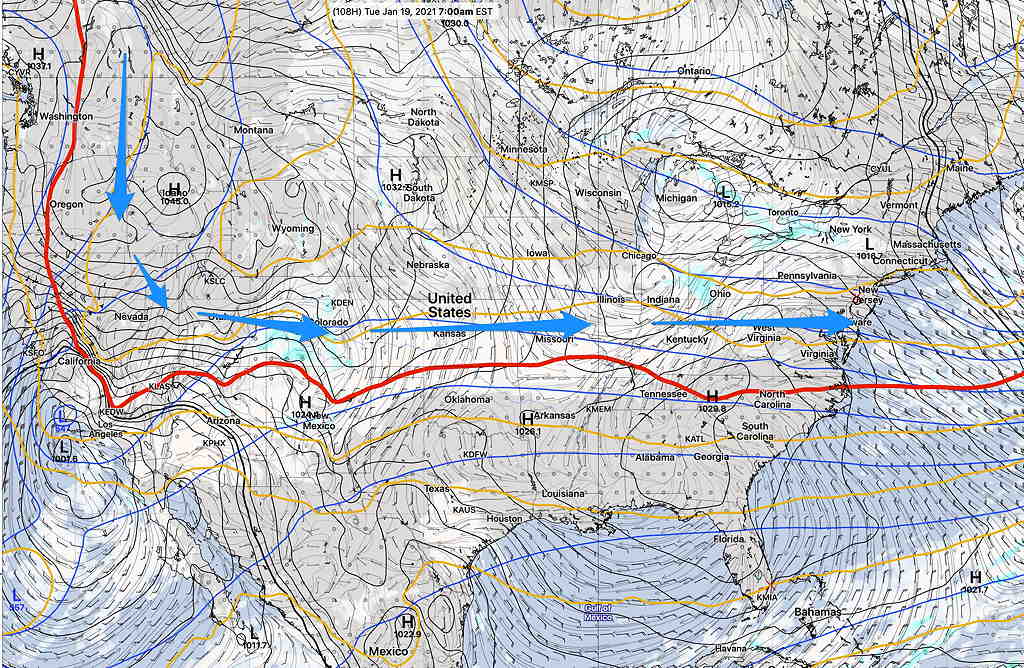
A mostly flat, zonal upper air flow for next week.  Disturbances moving in this flow will bring cloudiness at times, despite the lack of any major storm development. In past winters, this might have been a setup for ice storms in the midwest at the air mass boundary, but a lack of extreme cold and a lack southern jet moisture seems to have ruled that out for the time being, but it’s something to watch out for—

Canadian Global for next Tuesday showing flat upper air flow. (Click on image for a larger view.)

I’ll update later this evening for any changes, but the forecast models have been fairly consistent over the past few days.

COLDER, ACTIVE WEATHER PERIOD COMING UP

Thu 09:30 AM Update — What had been expected to be a colder, active pattern next week (title of original post) is unfolding to be a seasonably cold, uneventful pattern.   A flat and zonal flow as depicted in the “540  thickness” line (RED) of the Canadian Global model captures the uneventful flow and is NOT conducive to storm development—
Canadian Global model forecast for next Friday, Jan 22nd.  Red line (“540 thickness line”) couldn’t be much flatter and  it’s not conducive to storm development.  (Click on image for a larger view.)

We’ll have a dip in the jet this weekend with an upper low affecting our area, but the original expectation for a continued amplified pattern next week has faded. As for the very cold weather, temperatures in Canada have significantly chilled, but there’s no indication at this time that it will move down to affect our area.

Addendum: Here’s the current day temperature deviation compared to the period 1979-2000— 

GFS temperature anomaly Dec 14th compared to seasonal average 1979-2000. (ºC)  As cold as things are getting in northern Canada, temperatures are relatively warmer than average.  (Click on image for a larger view.)

Wed 09:48 AM Update — After looking at the latest GEFS (statistical ensemble) model as far out as it predicts -384 hours in the future – I don’t really see any intrusion of extremely cold air showing except in the far northwestern US.  In fact, the jet flow is looking rather ‘flat’, (not amplified) so previous expectations of an active pattern next week may be incorrect.  The flat pattern does not lend itself towards storm development.  Cold air starts building in as shown below in the forecast for Sat, Jan 23rd below, but that’s a ways off—
GEFS forecast Saturday Jan 23rd showing high pressure building in. (Click on image for a larger view.)

Tue 10:52 AM Update —  A plunge of cold air will cause low pressure development over our area Saturday.  It looks like RAIN for our area on Saturday.
Despite talk about  displacement of the”the polar vortex” as suggested by signs of “stratospheric warming”, current statistical models have deep cold in Canada, but not deep or cold enough to extend into the US at this time.  Current minimum temperatures from the statistical ensemble model (GEFS)—
Minimum Temps GEFS model for Monday 7 AM EST (Click on image for a larger view.)

This morning’s models are beginning to show an outbreak of very cold air around the last week of January.

Mon 06:22 PM Update — The pattern change expected over the weekend is still showing in the models.  It appears it will be too warm for snow here, but there’s high uncertainty about Saturday’s forecast. Low pressure is expected to develop along the coast or slightly inland, keeping us in the warm sector, maybe with a brief changeover to snow before ending Saturday. Stay tuned.  

This winter has been relatively quiet with average to above average  temperatures, and with the exception of one storm, not much snow. 

As mentioned in several posts over recent days, the models having been showing a strong signal towards a pattern change during the period January 16th through January 20th.

Colder air has been building in Canada and it appears that a southward plunge in this cold air will start occurring during the above timeframe, forcing a dip in the jet stream as a jet streak (1) causes the development of low pressure—

GFS version 16 forecast for Friday- 10 PM  (Click on image for a larger view.)

The models have not come together with exact timing and placement of this plunge.  The GFS (version 16) has rain, changing to snow for this first impulse: not a big storm. 

GFS 16 forecast Saturday, 1 AM  (Click on image for a larger view.)

The Canadian global model is similar to the GFS 16, with snow developing Saturday morning.

I should add that the current, operational GFS (version 15.2) is faster and does NOT have this storm form until the impulse is north of us—

Current Operational GFS version 15.2 Forecast for 1 PM Friday


Either way, colder temperatures are expected next weekend.

On the horizon is another impulse (#2 above), which depending upon the model, shows the possibility of a significant nor’easter a few days later.

It’s way too early to really know specifics, but the take-away is that colder temperatures are on the way next weekend and a more active winter weather pattern likely follows.

Weather… and Other Things 'Up in the Air'