NOR’EASTER EARLY TUESDAY

Tues @ 11:02 AM Forecast Review — This storm showed the limitations of numerical weather prediction (“weather models”) in forecasting complex atmospheric processes.

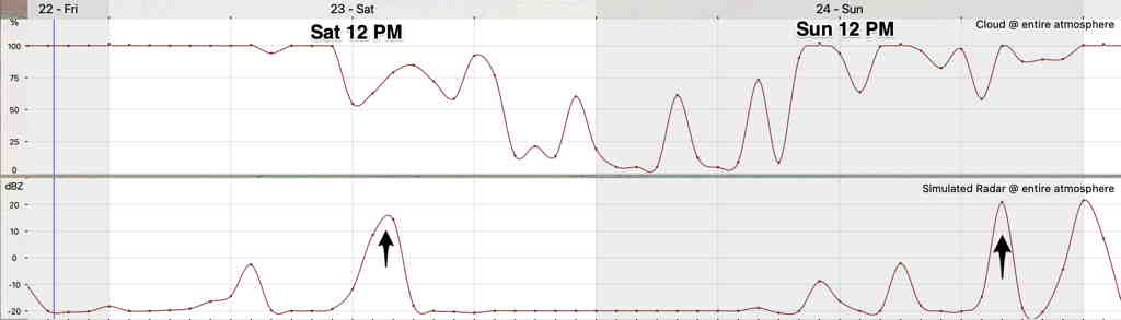
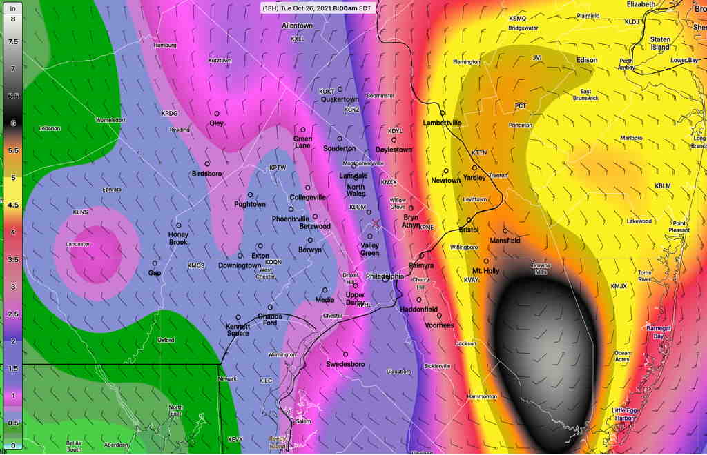
While it accurately predicted the transition of a beautiful day Monday into a rainy night at 8 PM, it could only approximate the general placement and amounts of heavy precipitation—

MRMS rainfall totals since last night as of 9 AM Tuesday. (Click on image for a larger view.)

As is often the case, and especially obvious with snow storms, the exact placement and amount of precipitation could be somewhat in the ballpark but not at all exact. The evolution of this complex storm was also off. There’s sunshine now breaking through clouds now instead of heavy rain.

With all the current limitations that exist with the resolution and quality of weather model input data, the mathematical constraints in calculating physical processes in large volumes that result in precipitation, and the non-quantifiable chaotic processes that play a part in atmospheric motion, this is probably the best it can be right now.

It’s something to remember when snow threatens and the same precipitation forecast limitations are magnified on the rain-snow scale of 9-18 times after you throw three dimensional temperatures into the mix.


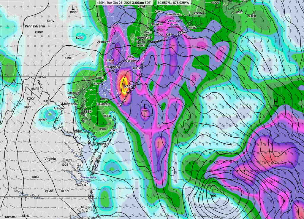
Update Mon @ 10:23 PM — Tonight’s early models (HRRR, NAM and NAM-NEST) continue with very heavy rain through tonight and much of Tuesday morning, then intermittent periods of rain through Tuesday evening. Winds become more gusty on Tuesday.
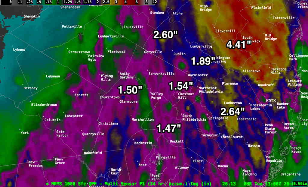
Total rainfall in our area 3- 4.5” with higher amounts possible north and east!


Update Mon @ 7:37 PM — This afternoon’s models are on track with the forecast immediately below. Updates about 10:30 tonight with the latest models.

This afternoon’s GFS accumulated precipitation by 8 AM Tuesday. Color scale on left of graphic. These precip maps can’t be taken too literally, but it gives an idea of the amounts of rain being forecast. A sharp reduction from extreme values right through Philadelphia. (Click on image for a larger view.)

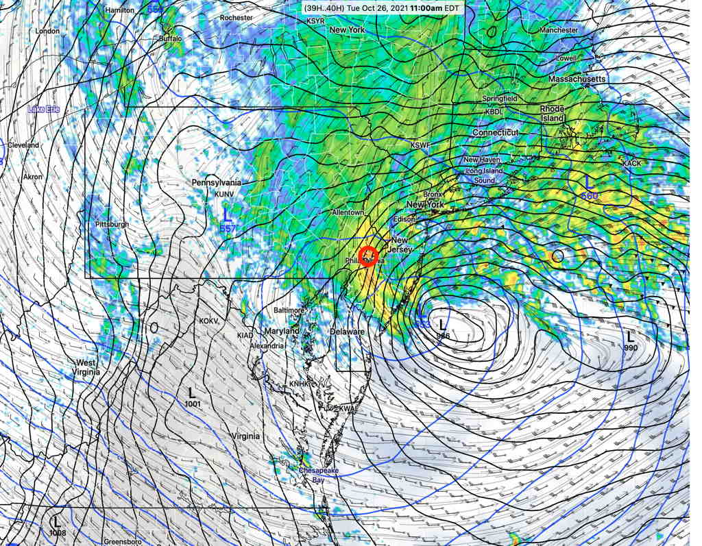
Update Mon @ 11:39 AM—Meteorologically fascinating is how I would describe this morning’s models, with 3 low pressure systems. 2.5-4 inches of rain, continuing through Tuesday! Updates later.

HIRESW-ARW-MEM2 model (high resolution) forecast for 2 PM Tuesday, showing THREE low pressure systems, one forming right over us, with rain being swept back into our area well into Tuesday evening as the stalled upper low causes the system to linger. (Click on image for a larger view.)


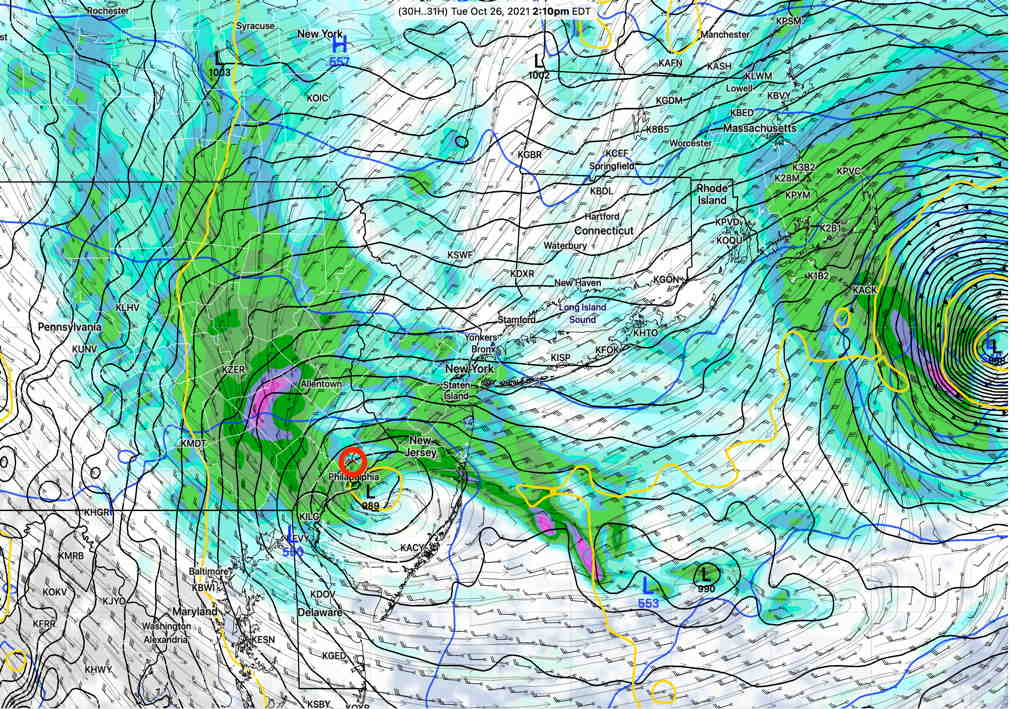
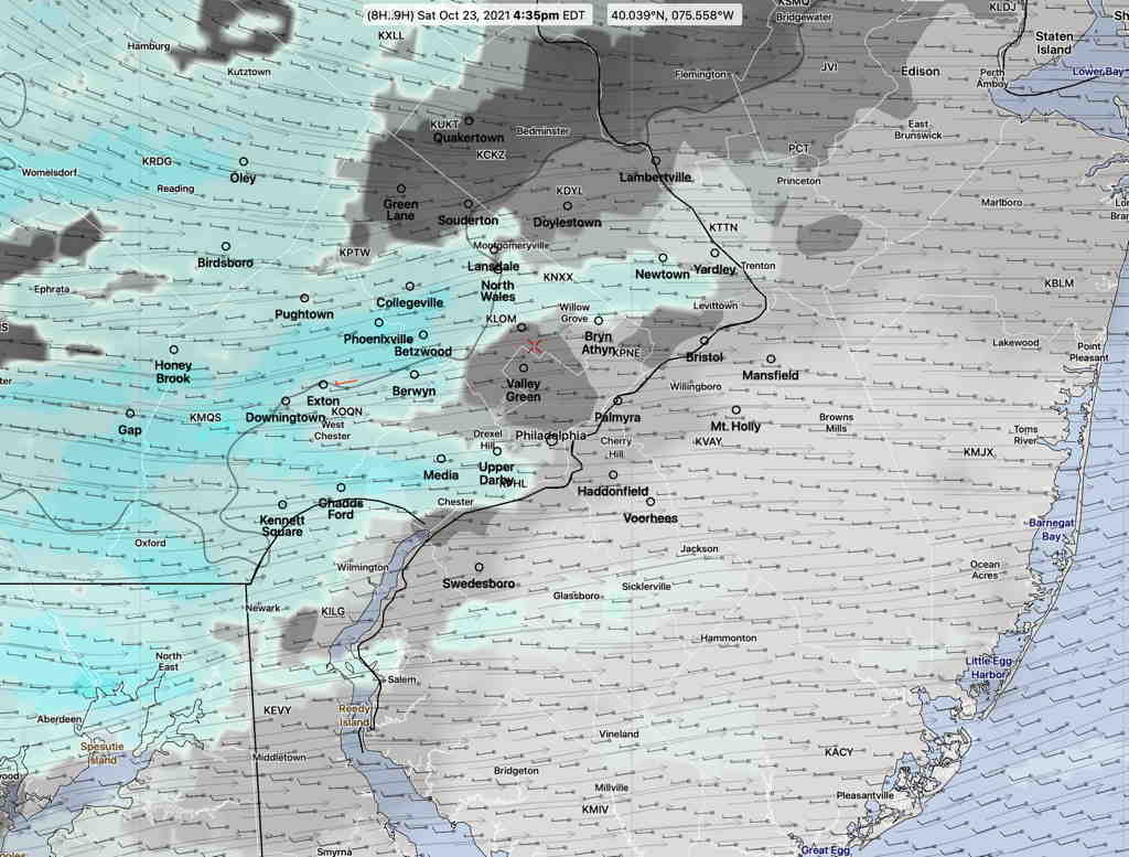
Update Mon @ 9:38 AM—Last night’s model runs continue on track with a complex coastal system to develop after midnight Monday into Tuesday as discussed here. The complexity of the expected system is such that the NWS is calling it a “low confidence, high impact event”. I can certainly see why; the current position of the upper low (as seen on water vapor) is south of the GFS and RAP model’s forecast positions—

Current water vapor position of upper low (L) and the position of the upper low that has been forecast by the GFS/RAP models (L) (Click on image for a larger view.)

The complexity of the secondary coastal system(s) expected to form (actually, the GFS has been showing THREE low pressure centers) and the difference in the model’s current forecast position causes one to question the model solution.

That said, the models are showing a generalized 2-3 inch rainfall with greater amounts in NJ and northeastward starting as early as 8 PM with the main action after 11 PM Monday and ending/tapering off later Tuesday afternoon. High winds look to be less of an issue in our area until gusty winds develop later Tuesday with the storm’s departure.

More updates later today.


Update Sun @ 11:12 PM — Tonight’s short range models continue to show an impressive coastal storm that may linger off the NJ coastline, according to the latest NAM and NAM-NEST models.

Showers break out about 8 PM, but the real action will begin closer to 11 PM Monday night and beyond. Wind gusts in excess of 40 mph.

While some models (Canadian GEM and HRRR) have lower amounts of rain for PHL (~ 1 inch), the latest SREF, NAM and HIRESW models have likely amounts of 2-4 inches, with the rain circling back over us during Tuesday afternoon! Even higher amounts along the Jersey shore. It’s a complex system with some models showing three low pressure centers!

NAM NEST simulated radar/pressure at 11 AM Tuesday. (Click on image for a larger view.)


Update Sun @ 5:42 PM— This afternoon’s models continue to forecast a deep secondary low formation off the coast that will result in heavy rain in Philadelphia and even more to our east.

Current estimates based on the latest GFS, HRRR, NAM, NAM-NEST and ICON show 2 inches of rain for the PHL area starting about 11 PM Monday night and continuing into Tuesday with gusty winds in excess of 30 mph. Heavier rain to our east. (see below)


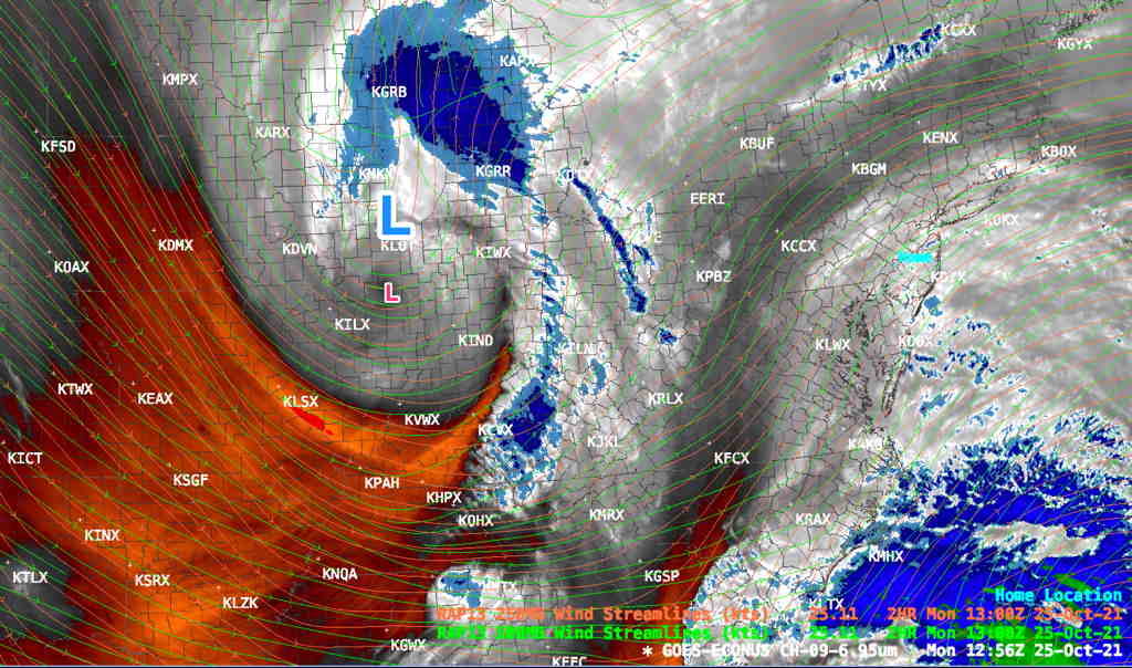
Since Friday, there have been huge changes in what was then the extended forecast period Monday through Wednesday. Huge low pressure in the Midwest had been forecast to move up towards the Canadian provinces, dragging a cold front through our area.

Things have changed.

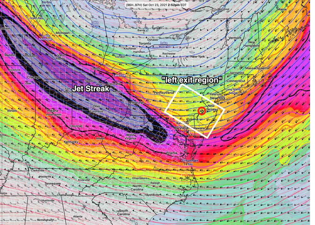
A disturbance in the southern jet stream flow looks like it will “phase” with the dip in the jet flow of the northern jet.

GFS jet stream forecast Monday 6 PM Northern and Southern jet streaks are in-phase and will form a new low (white circle area) (Click on image for a larger view.)

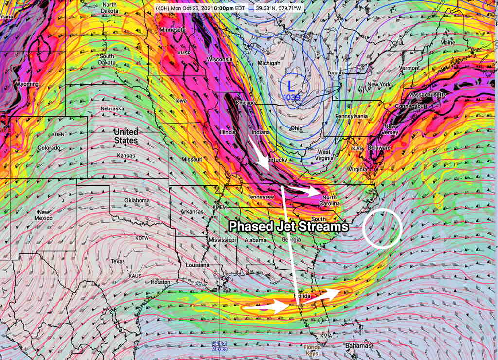
The deep closed low over the Midwest/Great Lakes, rather than moving northward into Canada, will rapidly spawn a deep secondary surface low off the coast while the energy of the closed upper low moves directly over us on Tuesday.

GFS Surface pressure forecast Monday 11 PM (Click on image for a larger view.)

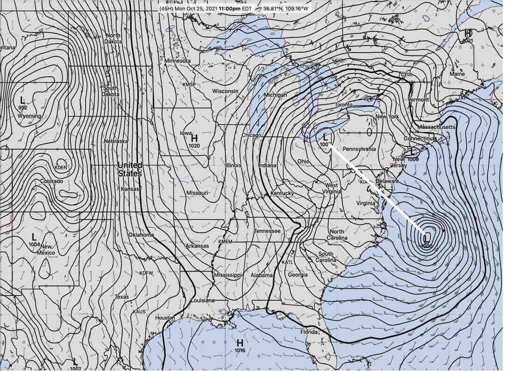
It appears that explosive cyclogenesis (referred to by the TV weather entertainers as “Bombogeneis”) may occur as surface barometric pressures drop rapidly. (Sustained drop of > 24-30 millibars pressure per 24 hours)

The exact timing and placement is still not pinned down (the storm may mostly affect the Jersey shore) , but the GFS is forecasting heavy rain (2 inches) with high winds here after midnight Monday into Tuesday, with much more extensive flooding rains (4”+) and yet higher winds along the Jersey Shore. Parts of Long Island and New England may be further impacted. The entire system may linger.

GFS accumulated rain Monday 3 AM (Click on image for a larger view.)

I’ll be posting additional graphics during the day today. Stay tuned.

WEEKEND WEATHER FORECAST

Update Sat @ 9:50 PM — Sunday’s forecast is unchanged. Some “interesting weather” appears to be developing for the late Monday through Tuesday time frame. A deep upper low will spawn a deep coastal secondary low Monday night through Tuesday. Stay tuned.


Update Sat @ 9:31 AM — The uncertainty in the cloud cover remains for Saturday. The short range, higher resolution models are more optimistic about brightening skies and some sunshine during the mid-day hours. But the 2AM runs of the the GFS and ICON have the clouds hanging in. I’m now leaning towards less sunshine, but with low confidence.

All models now show showers moving in from the west, starting as early as 2-6 PM. The model blend (NBM) which is supposed to reconcile these forecast differences has showers moving in about 4 PM.

NBM forecast for rain/clouds Sat 4:35 PM (Click on image for a larger view.)


Update Fri 10:43 PM Tonight’s models just becoming available, continue with a huge range in cloud cover for Saturday. I’m staying with the forecast below. Showers as starting as early as 3-4 PM, lasting into the evening, appear to be more likely.


The general forecast for this weekend is easy if you’re not into the details. Basically it will be partly cloudy/partly sunny with a chance of light scattered sprinkles late Saturday afternoon.

The detailed specifics of the weekend forecast are much lower confidence than usual.

Much of the forecast is driven by upper air disturbances (described on Tuesday) which are difficult to pin down. There’s a wide range in the forecast levels of cloudiness, especially on Saturday. Additionally, over the past few days, the timing of the showers/sprinkles (if any) from an upper air disturbance has moved from the morning to the mid to late afternoon.

Saturday

Going with a blend of the NBM, HRRR, GFS and ICON models, it looks like Saturday morning will be cloudy. Clouds break for a mix of clouds and sunshine sometime between 11 AM and 2 PM. There’s a slight chance of widely scattered light sprinkles after 4 PM.

High Temp 61.8º sd 3.3º (NBM forecast, Blue Bell). The high sd (standard deviation) reflects the high uncertainty in the amount of cloud cover. (Average seasonal high is ~62°.)

Mostly sunny in the morning with a period of increasing cloudiness in the early afternoon, possibly breaking for some sunshine late afternoon.

High Temp 61.4º sd 2.1º (NBM forecast, Blue Bell).

Looking ahead

After months of heavy rainstorms, recent weeks have been very dry. Our next rainfall of any significance is not on the horizon. Monday was supposed to be somewhat rainy, but much of that rain will move to our north.

It’s interesting that the publicized NWS Climate Center long range winter forecast released yesterday had the above-average precipitation area just north of our area, with our area having equal chances of above or below average precipitation.

Some rain Monday night into Tuesday may provide some relief in the dryness. A deep upper low will spawn a coastal low Monday night through Tuesday. High winds and heavy rain are possible

THIS WEEK’s WEATHER OUTLOOK

Update Thu @ 7:40 PM— The models are still trying to come together with this weekend’s forecast. Today’s GFS and NAM have returned to the earlier forecast that our area will be in an area of jet stream level lift and upper air disturbances on Saturday, causing cloudiness and possibly some light sprinkles until after noontime. Greatest chances of sprinkles areas north of the city. Then breaks of sun and clouds for the rest of the day.

Sunday looks to have some sun early morning, then significant periods of cloudiness and some bright spots.

Here’s a meteogram based on the latest GFS model cloud and simulated radar forecast for Blue Bell, PA (remember that meteograms are only for a single location, but in this case, most of the PHL area forecast will have somewhat similar conditions) —

GFS forecast Sat and Sunday total cloud cover and simulated radar for Blue Bell PA. Cloudiness Saturday morning gives way to some bright spots and sunny breaks. Arrows suggest possible sprinkles of rain. (Click on image for a larger view.)

Update Wed @ 8:17 PM Friday and the weekend continue to look better.

Two cold fronts move through and the expected drop in high temperatures to more seasonable levels is apparent from the NBM (model blend) forecast meteogram for Blue Bell—

(Click on image for a larger view.)

On Saturday, the upper air disturbance moves to our north and west giving us clouds in the morning but breaking for partly sunny skies in the afternoon. Any showers on Saturday will be mostly to our north and west and will be light.

Sunday starts cloudy with breaks of sunshine by afternoon.


Update Wed @ 9:51 AM—This morning’s NBM (model blend) has fewer clouds both Friday and Saturday. (Clouds move in later Friday afternoon and dissipate Saturday morning.) Last night’s GFS also moved in that direction. Will keep an eye on it.


Tues 8:39 PM:

We’re having some fantastic sunny, mild autumnal weather and it will continue through Thursday. Temperatures are well above seasonal averages (Avg Hi 62º Low 43º Blue Bell, PA)

A cold front will slowly move through on Friday with cloudiness and possibly some very light showers. The front will stall to our south. Upper air disturbances will move through on Saturday with cloudiness. It looks like we’ll be in the “left exit region” of the jet streak, assisting the development of light showers on Saturday from these upper air disturbances.

A secondary cold front will be pulled in behind the disturbance giving us more seasonable (read colder) temperatures for Sunday.

Weather… and Other Things 'Up in the Air'