Updated Fri @ 9:58 AM — Some higher-resolution data coming in for Sunday’s forecast. Rain in the early morning. Then a break in the showers early afternoon, with even some sunshine.
Temperatures in the 60s! Becoming very WINDY. A line of showers moves through 4-6 PM with the cold front. Temperatures drop with gusty winds. Showers may linger into after midnight, then possibly change to snow showers.
Updated Fri 9:29 AM — Last night’s NAM and Canadian GEM and European ECMWF have followed the GFS in predicting another area of low pressure developing. However, for snow lovers, this low pressure system will, at most, brush us as it departs northeastward. Currently, at most, a coating of snow possible at daybreak Monday. This coating is most likely possible in southern NJ, Cape May—
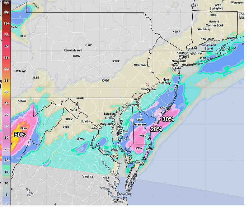
This morning’s NBM12z Accumulated snow probability > 0.10 ” by Monday morning. Low amounts, low probability, limited areas. (Click on image for a larger view.)
Just not a large enough cold air mass or amplification of the jet stream for it to give us snow here. But I’ll keep an eye on this. My regular weekly, “Weekend Weather Forecast” will be posted this evening.
Update Thur 6:40 PM— The GFS forecast below for Sunday is currently an outlier, with the European (ECMWF) Canadian (GEM) and German (ICON) models have the precipitation missing us, exiting to our south. This is an evolving forecast.
Cold air, which has been conspicuously absent this past month, has been building up in northern Canada and indications are that it has reached enough critical mass to plunge (at least temporarily) down into the continental US and into our area by the end of this weekend.
A strong frontal boundary has developed separating the very cold air from unseasonably warm air. Low pressure systems have been developing and ejecting towards us in this warm sector, giving us the clouds and occasional showers these past few days.
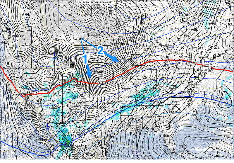
Currently, the cold air is expected to plunge southward and then eastward. Depending upon how far southward vs eastward will determine the shape of the jet stream and the path of low pressure expected to develop on the front.
GFS forecast for Friday at 7 PM. Will the high pressure system move mostly southward (1) or more eastward (2)? The more eastward plunge (2) was forecast, but the trend has been more southward (1) over past days. The red line is 540 thickness line, a rough estimate of the contour of the cold air mass. (Click on image for a larger view.)
New Years Eve
Cloudy and mild. Rain doesn’t get here until 2-5 AM Saturday morning.
Saturday
Some rain in the morning. Heavier rain by mid afternoon.
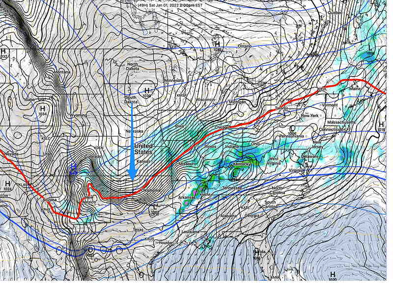
GFS forecast 2 PM Saturday. The plunge seems to be more southward. (Click on image for a larger view.)
Sunday
This forecast is still evolving. This is preliminary. Some rain early, becoming WINDY. The front comes through either mid afternoon or later, somewhat influenced by the degree of low pressure development. If the low tracks northward, the usual rain-snow dividing line may set up here.
Here’s the latest GFS model, just available —
GFS forecast for Sunday midnight. Red thickness line is the rain snow line. Not clear which path this low will take. (Click on image for a larger view.)Latest GFS forecast for 5 AM Monday morning. Some snow forecast for Philadelphia. (Click on image for a larger view.)
Update Thu @ 12:44 PM — On Tuesday, I mentioned the possibility of a coastal low forming after the cold front moves through Sunday evening. The ‘possibility’ didn’t show on yesterday’s models, but last night’s ensemble models began showing something possible.
Today’s GFS shows a full coastal system developing later Sunday night.
Todays GFS (12z) shows low pressure developing Sunday night. Path is still offshore just missing us, but this needs to be watched. (Click on image for a larger view.)
Right now the models have the new storm just brushing us as it moves northeastward, but the current forecast for the weekend has begun to change today. I’ll update this evening.
Update Wed @ 7:04 PM — Continued mild through Sunday afternoon. Different low pressure systems move over the next two days, mostly during the nighttime hours, with gradual partial clearing during the daytime hours.
More specifically, Thursday looks to be mostly cloudy after morning showers move out. High in the mid 50s
Friday will be the nicest day, with sun expected to break through a thin cloud layer and mild and dry. High mid 50s.
The models are in fairly good agreement for this weekend.
New Year’s Eve will be dry and mild but rain will move in several hours after midnight.
New Years Day will be rainy, but mild.
Sunday starts rainy, but the rain becomes more sporadic in the afternoon. The specifics for Sunday’s forecast are not quite final, as a strong cold front moves through on Sunday about 6 PM with showers and gusty winds.
Temperatures drop rapidly. Residual showers may turn to snow flurries.
Update Tue @ 5:50 PM — A pattern change is shaping up for the country and our area, as cold air has been building up in northern Canada and appears to be poised to make a plunge into the continental US next week, pushing the jet stream southward. This change will occur for our area towards the end of the upcoming weekend. (I recently made mention of my approach to conceptualization of jet stream positions in a recent post about our mild winter.)
A cloudy, unsettled pattern will be with us through Saturday, New Years Day as we’ll be on the warm, moist side of an approaching upper trough. Low pressure systems will be moving up along this slowly approaching boundary, bringing us periods of rain. Timing these systems will be an important part of the forecast.
Of interest is the possibility that low pressure may develop as the strong cold front moves through sometime Sunday. Light snow may be possible late Sunday or Sunday night. Stay tuned.
Mon 05:23 PM Forecast Review —So we had a few wet flakes and a few drops of rain around noontime.
But overall, the models over-predicted the chance of snow and over-predicted the amount of precipitation. The GFS did incredibly poorly with this forecast and didn’t correct itself until this morning’s run which first became available at 10:45 AM.
This is the first full winter for this version (16) of the GFS, which became operational last February. It’s something to keep in mind going forward this winter.
(Even the European model [which I have limited access to] incorrectly predicted about 0.4 inches of snow.)
So did any models get this forecast right? Well, last night’s HRRR did pretty good and the ICON model did well. The new Canadian models (which were just upgraded two weeks ago) didn’t fare all that well, but did better than the GFS. The GEFS from yesterday did well, but it went in the wrong direction last night. The high resolution HIRESW suite of models also over-predicted snow.
The model blend (NBM) did pretty good with it’s median forecast of 0.00″ snow, but it over-predicted the rain during the day.
So, in summary, yesterday’s HRRR, NBM, GEFS and maybe the ICON were the winners. Something to keep in mind for the next time.
Following a beautiful day today, Sunday, the weather model guidance shows a trend towards colder weather and a somewhat unsettled weather pattern.
But first, Monday—
I should begin with the acknowledgement that Monday’s possible snow showers do not merit the amount of attention I’m giving them. But, I just don’t want to get too rusty predicting snow this season…
Update Mon @ 8:47 AM— The latest SREF model just available has changed its forecast to rain only here in the immediate PHL area, with light snow north of Quakertown. Over past years, the SREF precipitation type has done well. I guess we’ll see.
SREF 09z PTYPE (precipitation type) forecast. green= rain (Click on image for a larger view.)
Updated @ Mon 7:31 AM— Latest GFS in a similar range as the posted graphic last night. NBM percentile predictions continues with 0.00” to 0.22”, a coating at most
All changes to light rain after 2 PM.
Update Sun @ 11:04 PM — Tonight’s models, as usual, have a range of forecasts for tomorrow’s light snow. The range of accumulations is from about 0.5 – 0.75“ (GFS) to 0.0 (ICON).
Falls between 10 AM and 2 PM.
The NBM which is designed to sort through these discrepancies has a median of 0.00 “ to a possible coating. I think we’ll go with the NBM.
Turns over to light rain after 2 PM.
Update Sun @ 7:45 PM — The GFS has a statistical ensemble version (GEFS) which just became available. Its snow forecast seems more reasonable for us than the GFS posted earlier—
GEFS 18z ensemble forecast snow depth for 4 PM Monday. (Click on image for a larger view.)
Update Sun @ 5:25 PM — This afternoon’s GFS has come in as an outlier with today’s higher resolution models. It forecasts measurable snow for us Monday, while the other models have nothing accumulating. Hard to believe, but here’s the latest GFS—
GFS 18z forecast snow depth for Monday at 3 PM. This forecast is an outlier with today’s other models. (Click on image for a larger view.)
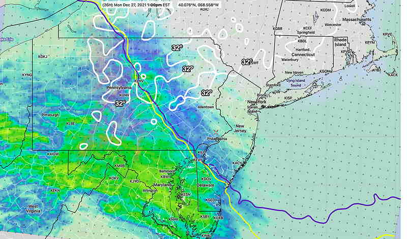
The front that moved through Saturday night is to our south and will return as a warm front. Moisture moving up ahead of the front on Monday will encounter a column of cold air. Several models have the light precipitation initially falling as light snow. There is agreement that surface temperatures will be above freezing and little if any accumulation is expected. (The GFS forecasts a coating.)
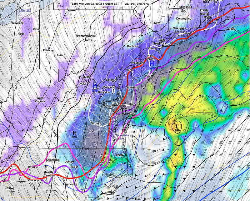
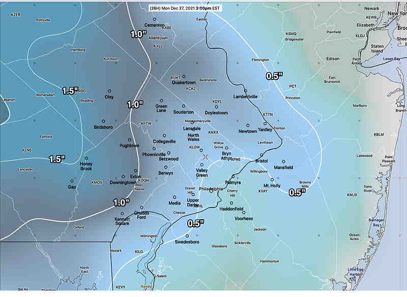
GFS forecast for 10 AM Monday with light snow. 32° surface temperatures north of Philadelphia. The violet, magenta and red contours are “critical thickness” lines used to determine rain-snow transitions.
The NBM also shows snow for early Monday, but extremely light amounts. The NBM median accumulation is 0.00”.
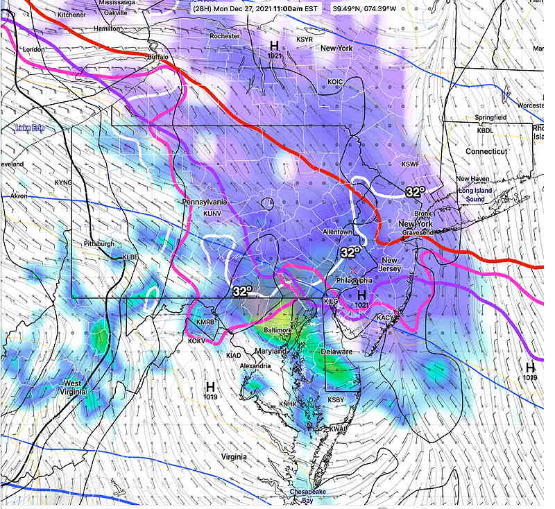
NBM radar forecast 1 PM with other determinant predictors of rain vs snow. Shown are the “wet bulb 600 + meter temperature 32° line” ( dark blue) and the “Bourgoiun Positive Energy” critical line (yellow). Both are south of us at this time signifying snow. However surface 32° line is well north of our area, signifying melting and minimal accumulation on the ground.
Whatever falls, there will be a changeover to rain.
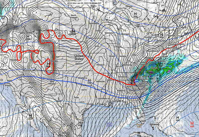
For the rest of the week the jet stream configuration over the continental US will transition from the current ridge, with warm air pushing northward, to a flat configuration.
Wednesday, cold air building in Canada is expected to flatten the entire pattern and push a just bit further south, keeping us consistently colder.
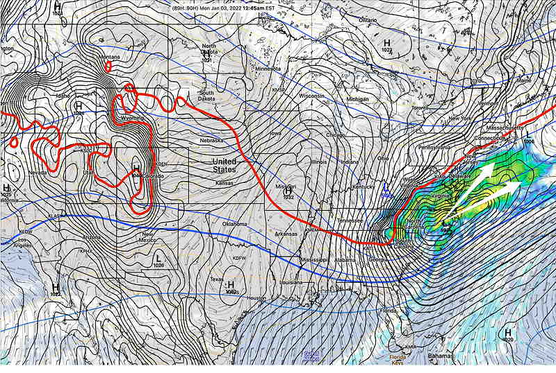
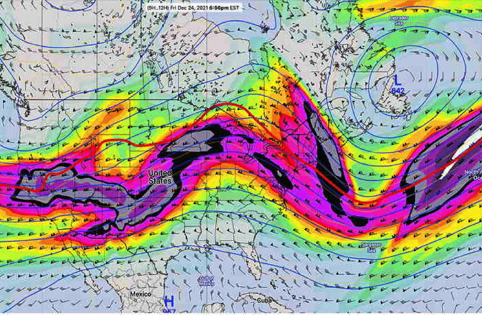
GEFS 300 mb wind (jet stream level) pattern expected to flatten after Tuesday this week, allowing a more consistent cold air flow to our area. (Click on image for a larger view.)
The same flat pattern will prevent any major storms from developing near us.