Category Archives: Winter Storm Outlook

MONDAY & Wednesday SNOW UPDATE

The latest models are just becoming available this evening. Most models have it too warm for snow in the immediate Philadelphia area.  Some snow accumulation is possible far western areas.  The NBM (National Blend of Models) 75 percentile snow accumulation captures it well. (75% of the constituent models and their statistical members are equal or below this accumulation amount)—

NBM 75 percentile snow forecast for Monday. (Click on image for a larger view.)


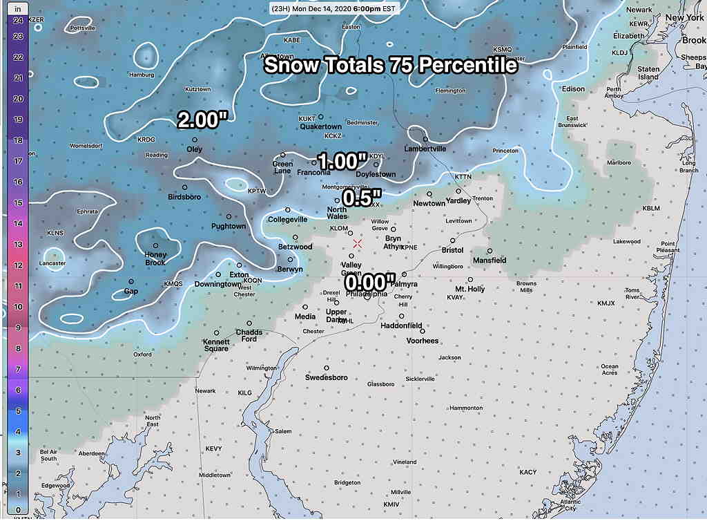
The latest HRRR and NAM, just available, is consistent with this NBM forecast. There may be some snow mixed with rain in areas that show zero accumulation towards the mid afternoon.

Rain starts around 6-8 AM Monday and ends about 3-4 PM.  It may briefly mix or change to snow in the western suburbs as it ends.


As for Thursday—


The models continue to show a major storm for Wednesday into Wednesday night.  It will be a stormy day by Wednesday afternoon with high gusty winds.  (At one point today, it appeared that warm air might move in, but the newest models are showing significant snow accumulation for Wednesday afternoon and night.) Here’s the latest GEFS snow totals by late Wednesday night—

GEFS Snow Totals (Click on image for a larger view.)


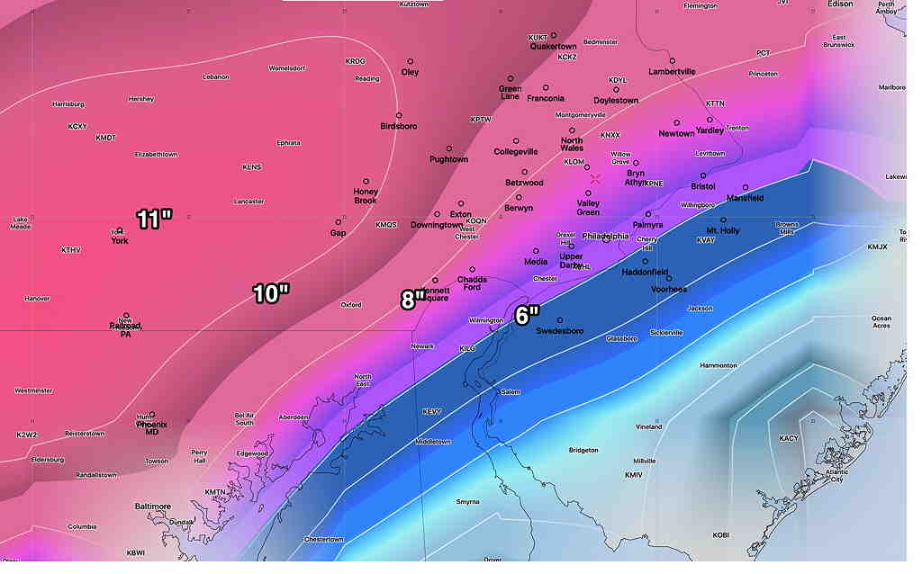
Here’s the NBM 75 Percentile snow totals—

NBM 75 percentile snow totals by late Wednesday night.  (Click on image for a larger view.)


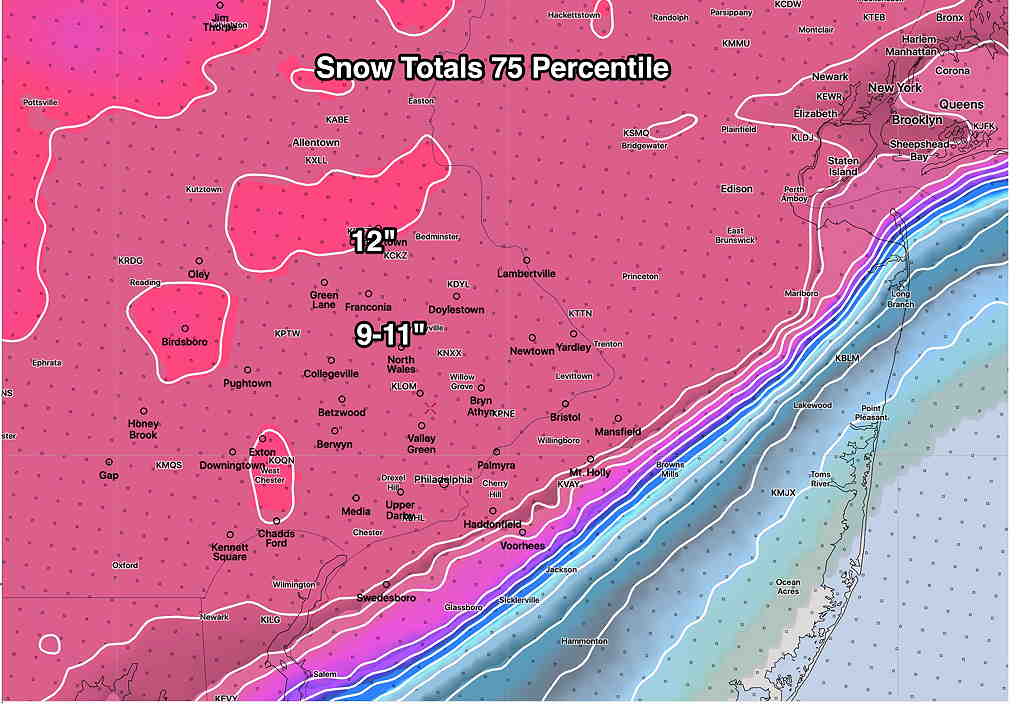
Very clear is the sharp cut off in NJ as temperature will be too warm for much accumulation there.

I’ll be updating during the week. Stay tuned.

INTERESTING WEEKEND WEATHER OUTLOOK

The dip in the jet flow that gave us the thunderstorms Monday and the colder weather today will be an ongoing feature of the weather pattern this week and this weekend.

Low pressure developing near the Gulf of Mexico at the end of the week will move up the coast this weekend. Any other year, this would be a recipe for snow with the track of this storm, but the theme of this year so far is what I call “the lack of really cold air”. 

There’s much uncertainty with the development, track and timing of this low pressure system. The current GEFS model shows the low pressure system at 1 PM Saturday—

GEFS Forecast for Saturday  (Click on image for a larger view.)

The German global ICON model has a more intensified low pressure system that takes a faster, more coastal track—

German ICON Global Model 1 PM Saturday  (Click on image for a larger view.)

The Canadian global is somewhat similar to the GEFS—

Canadian GDPS (“global GEM”) model  (Click on image for a larger view.)

All the models keep the storm warm enough for the precipitation to be RAIN for us on Saturday. (Some snow flurries early Sunday morning possible.)

Either way, Saturday looks stormy and Sunday looks to be windy and unsettled. This is an interesting scenario. Stay tuned.

SATURDAY SNOW (?) OUTLOOK

Updated Tues 08:24 PM—  Today’s models continue with the trend of the system moving faster past us (early Saturday) and mostly missing our area.  Any precip falling will be light and will be rain. The latest GFS and GEFS have it missing us entirely.

GEFS Forecast 5 AM Saturday. The path of the storm will follow the blue upper air contours.


From earlier Tuesday—

I took a fast look at the GFS before I went to bed last night and thought things had changed.  Too fast a look.  Things on the surface appeared to have changed to more snow, but not really.

This morning, I had a chance to look at the GFS, GEFS, Canadian, German ICON (yes, a new model for me) and ECMWF.    Here are the trends:

The GFS has taken a more westward track but is faster and warmer aloft.  So the new GFS gives us some rain here Saturday morning, but no snow.

GFS simulated Radar Saturday 9:30 AM  The blue line (critical temp for snow) is too far north.

The ECMWF, the Canadian and GEFS have different timing, with the Canadian having two separate centers, both  too far off-shore.  The other models’ placement is too far east.

ICON Ensemble Model forecast 1 PM Saturday- Surface Pressure percentiles

The ICON ensemble shows low pressure systems possible in various timing and locations, based on 10, 50 or 90 percentiles of possibilities.  All far to our east.

So the models show a storm that’s too far east, too under-developed or too warm or combinations of the above.  It doesn’t look like a snow storm for our area.

Getting back to my comment about storm tracks last night:  The “track” of a storm and its structure/speed/moisture/intensity/dynamics are inextricably connected.

To use the “track” analogy, when a storm is forecast to take a different track, it’s no longer same train on a different track.  It’s an entirely different train.

Using the expression “it depends on the track of the storm” dismisses the complexity and dynamics of weather systems.