Posted Thursday 04/03/25 @ 4:32 PM — The warm front moved north of our area today, Thursday, allowing very mild and humid air to move into our region. The same air mass boundary will return tonight as a cold front.
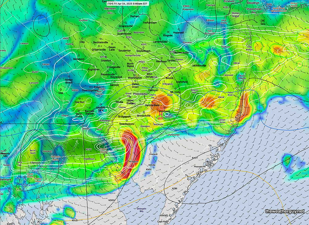
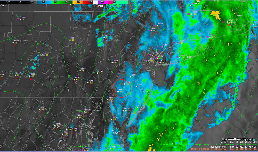
The air over us is unstable and there is will be enough CAPE, vertical wind shear and helicity to aid in the formation of some strong, possibly severe thunderstorms in the 2 AM -6 AM time frame. Some heavy rain is possible. Here’s the latest HRRR forecast—
18z HRRR simulated radar forecast for 5 AM Friday morning. Some very heavy thunderstorms in red. (Click on image for a larger view.)
Rain will continue through Friday morning, ending northwest to southeast during the early afternoon.
The same boundary will move north again as warm front on Saturday, with showers, thunderstorms possible late morning into Saturday afternoon.
Interesting Forecast
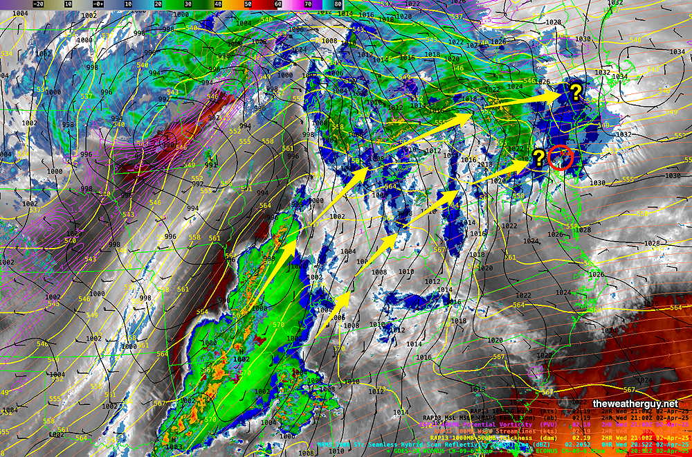
Posted Wednesday 04/02/25 @ 5:14 PM — The upcoming forecast period into the weekend will be interesting. The AI models are forecasting considerable rain in our area, while the regular numerical models are forecasting the axis of rain to be to our north. The current water vapor image illustrates this difference—
Current satellite water vapor image with superimposed RAP model 500-1000 mb thickness lines (yellow), Mean Sea Level Pressure isobars (black contours) potential vorticity (fine violet contours) with superimposed MRMS RADAR. There are two possible tracks for the expected stream of disturbances moving around the southeastern high pressure ridge. (Click on image for a larger view.)
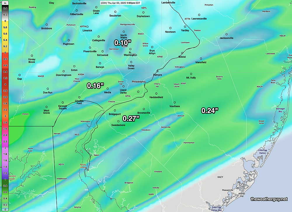
The latest HRRR has moved towards some rain over our area Thursday associated with a warm front moving through later tonight. Most of the rain will be ending around 12 noon – 1 PM from the city and westward.
HRRR (18z) accumulated rain through 1PM Thursday (Click on image for a larger view.)
There may be breaks of sun mid afternoon, but overall it will mostly cloudy. A weak cold front moves through Thursday evening with more showers into Friday morning. Then there’s uncertainty. The AI model shows plenty of showers for Friday Saturday and Sunday. Will need to see if/how the models are coming together!
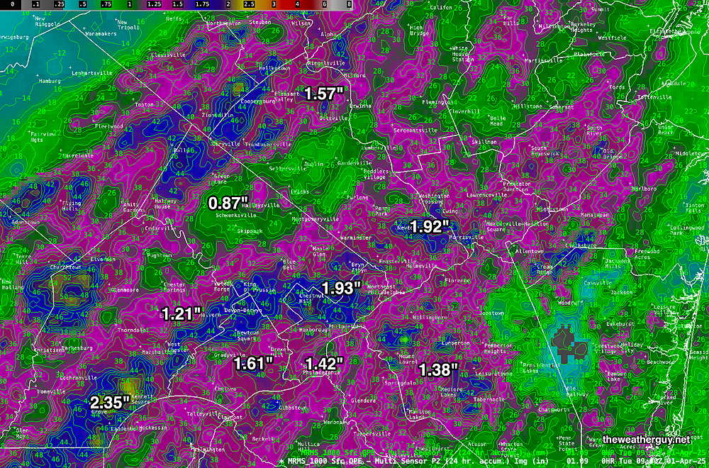
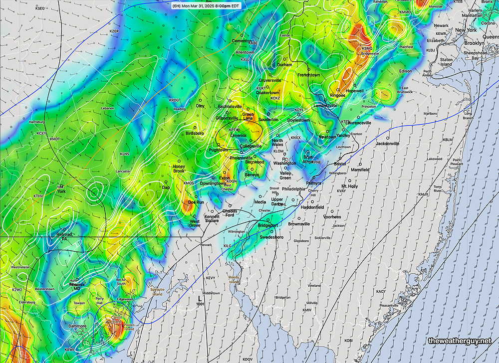
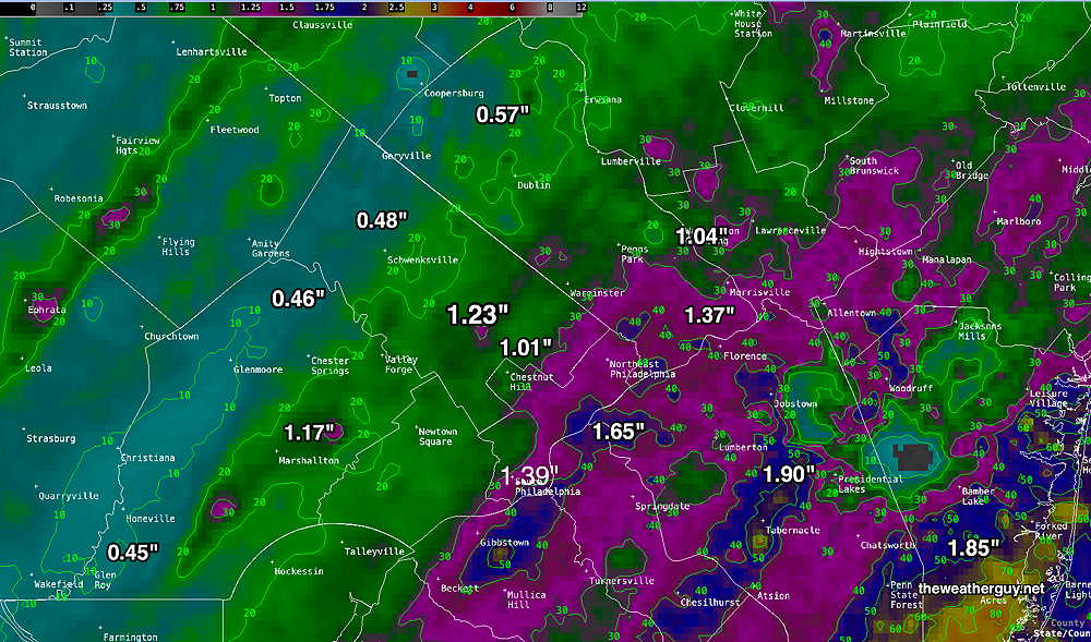
Wed 10:24 AM —Forecast Review — I just wanted to post the rain totals from Monday’s storms. Total (much needed) rainfall exceeded the model predictions.
MRMS rain-gauge measured rainfall combined with rain-gauge calibrated and interpolated radar-based summary of ACTUAL RAINFALL RECEIVED Monday March 31 into early Tuesday 4/1 . Color shading is in inches. Line contour numbers are in mm. (25.4 mm= 1 inch) (Click on image for a larger view.)
For part of this month of April, this blog’s weather updates will be less frequent than usual.
Monday Evening Storm Update
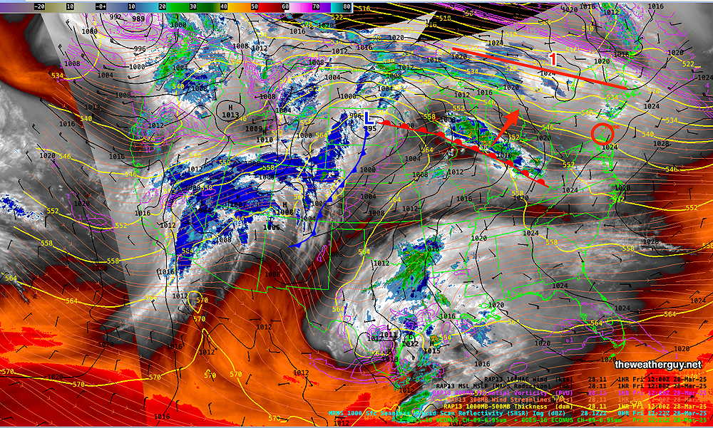
Posted Monday 03/31/25 @ 4:42 PM — No significant change from previous forecast update. Here’s the near-current water vapor/radar—
Water Vapor/Composite Radar with superimposed RAP model vertical velocity pressure (Omega- yellow contours) and horizontal moisture convergence (blue contours) and 700 mb wind streamlines. Area 1 shows enhanced upward vertical motion (positive Omega) , indicating intensification to occur. (Click on image for a larger view.)
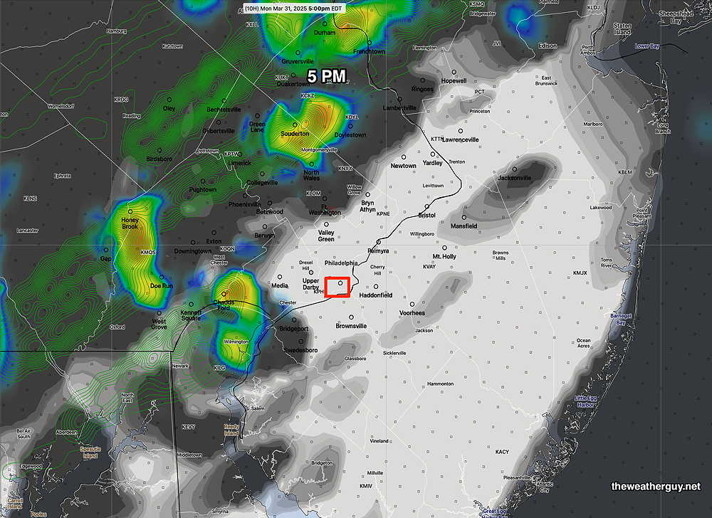
Here’s the latest HRRR forecast at 8 PM—
HRRR shows storms coalesce into a line with heavier cells at 8 PM (Click on image for a larger view.)
Monday Evening Possible Severe Weather
Posted Monday 03/31/25 @ 9:05 AM — A strong cold front approaches today and is expected to move through the Philadelphia area about 10 PM. Ahead of the front, unstable conditions will allow for the possibility of severe thunderstorms ahead of the front. The most likely timing is between 6 PM and 9 PM with a peak at 7-8 PM according to the latest HRRR.
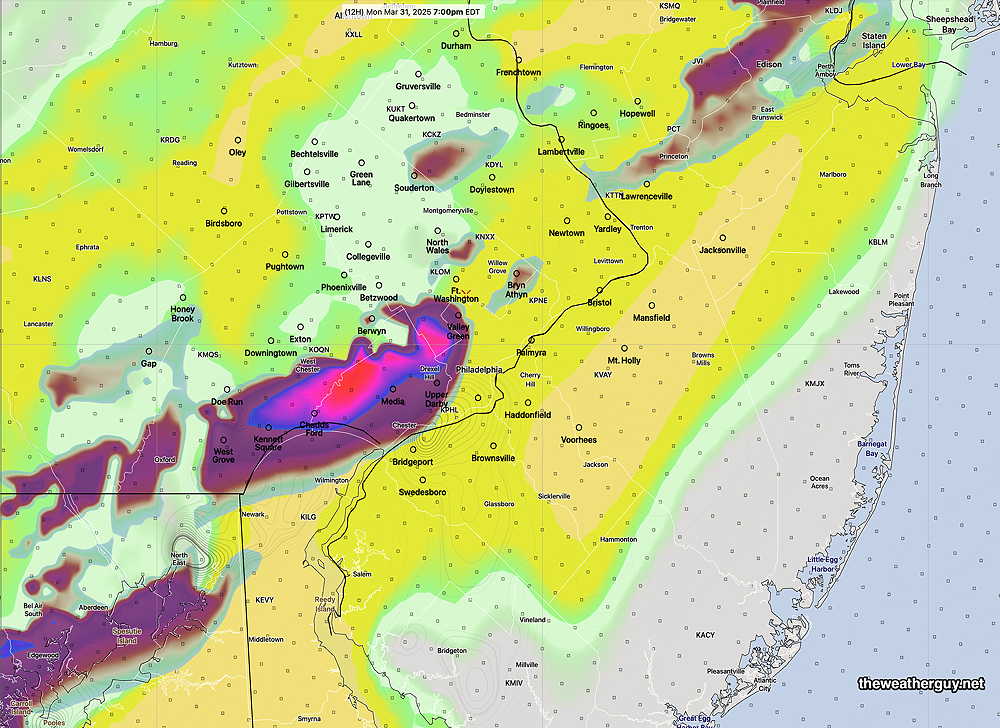
As for the Phillies opening game at 3 PM, most models keep any storms to the western suburbs, but the latest HRRR does show some possible activity closer to the city at 5 PM—
11z HRRR simulated radar and clouds forecast at 5 PM (Click on image for a larger view.)
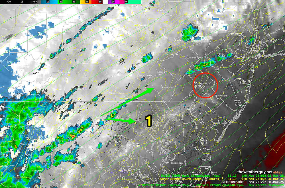
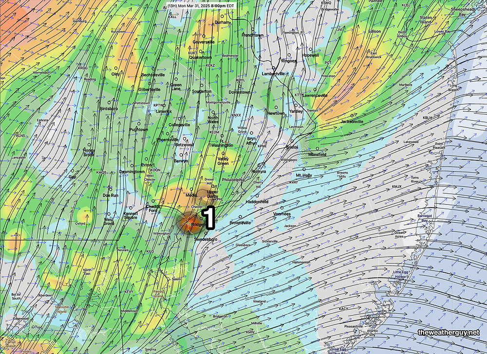
As mentioned, there’s the potential for severe weather, especially this evening. The HRRR shows areas of highly elevated severe weather parameters (vertical shear, helicity and upward helicity) approaching the city about 7 PM—
It should be noted that a high shear and helicity forecast at 8 PM shows possible low tornadic potential—
High helicity and vertical shear at 8 PM (1) shows low potential of tornadic activity. (Click on image for a larger view.)
As always, the model placement for the potential severe weather is rarely exactly where it will occur. (It’s only a model.) But the potential and general timing is what’s important.
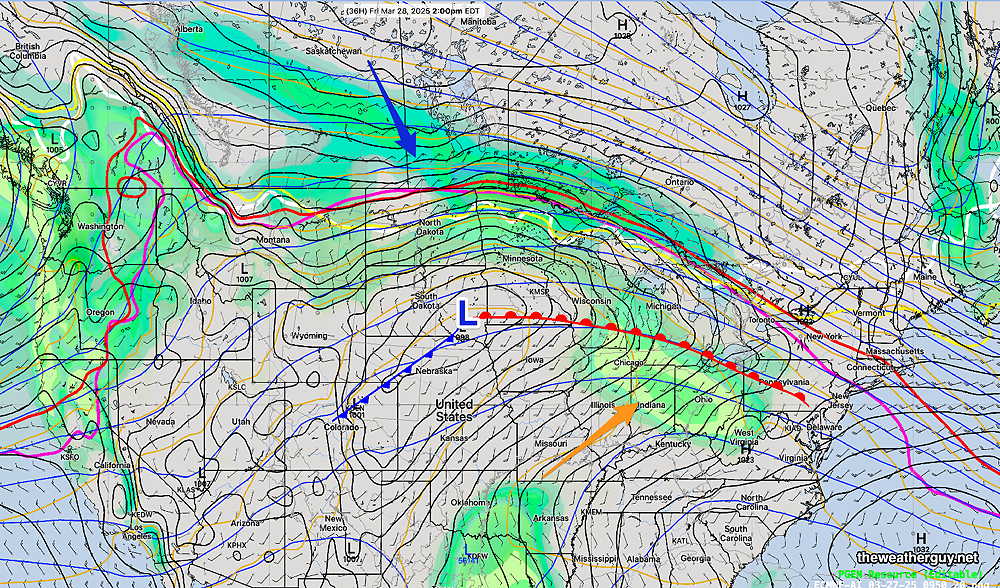
Posted Friday 03/28/25 @ 8:38 AM — Over the past several days, there have been significant changes in the model forecasts for this weekend. Here’s a brief summary—
The warm front will become stationary far north of our area. This area will be the focus of most of the rain for this weekend. Much of the rain will stay to our north. What had looked to be a wet latter half of Sunday, now appears to be much dryer.
Rain from the system will affect our area on Monday and Monday evening instead of Sunday evening into Monday.
Current water vapor image—
Current satellite water vapor image with superimposed RAP model 500-1000 mb thickness lines (yellow), Mean Sea Level Pressure isobars (black contours) potential vorticity (fine violet contours) with superimposed MRMS RADAR. The red line north of the red warm front will be the area that receives the most rain with this system. (Click on image for a larger view.)
As for today, Friday, most models still have the showers associated with the advancing warm front to pass us to the northwest. The ECMWF-AI, the HRRR and the NAM-NESTkeep a forecast of very light showers Friday evening, anytime between 6 PM and midnight.
I’ll post my regular “Weekend Weather Forecast” late this afternoon with an update.
Thursday and Friday Outlook
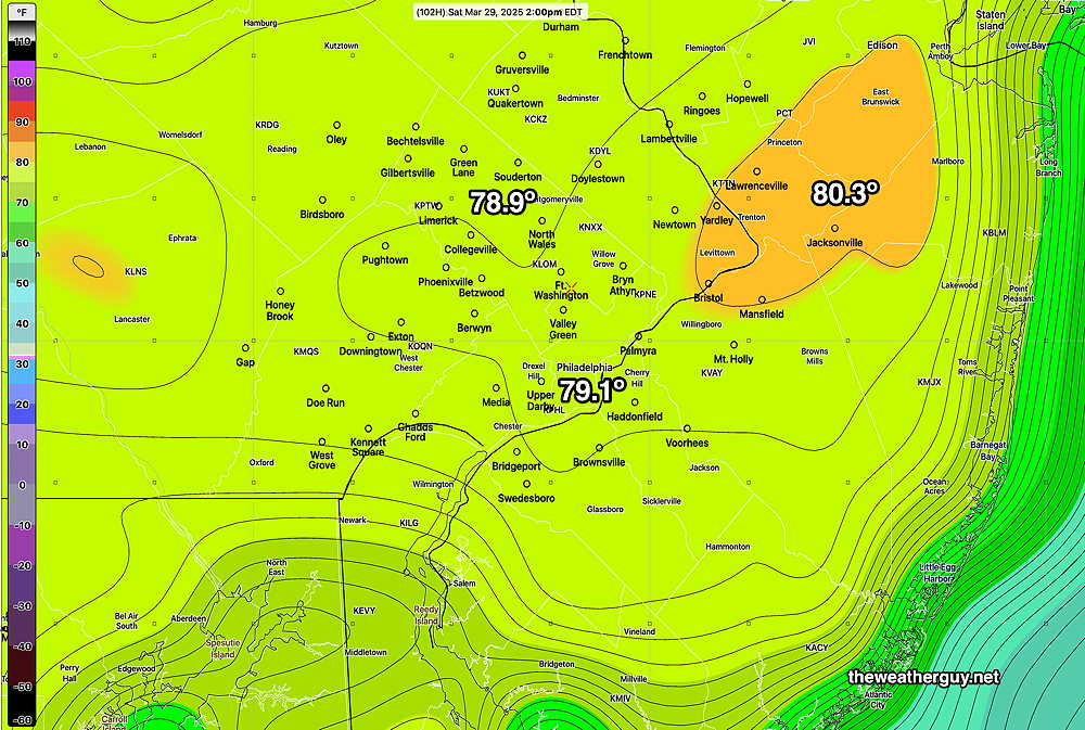
Posted Thursday 03/27/25 @ 10:04 AM — I’m finally hearing the words “near 80 degrees” for Saturday in the TV/Radio forecasts. The ECMWF-AI model has been predicting these temperatures since Tuesday.
For today, Thursday, it will be sunny and continued windy and somewhat chilly.
To get to 80 degrees, a warm front will need to pass through our area Friday night.
ECMWF-AI-Single forecast for 2 PM Friday.
Earlier this week, the models only showed showers to our far northwest with this warm frontal passage. The latest models are showing some showers breaking out as early as Friday afternoon ahead of the front.
Here’s the latest HRRR which is forecasting showers and thunderstorms as early as 4 PM Friday afternoon—
Latest HRRR (12z) forecast for 6 PM Friday evening. (Click on image for a larger view.)
Thursday and Weekend Outlook
Posted Wednesday 03/26/25 @ 5:15 PM — Showers formed, mostly to the north of the Philadelphia area today, and radar showed precipitaton over Philadelphia which evaporated before making to the ground. Significant shower activity broke out at the Jersey Shore this afternoon from the upper air disturbances discussed in this morning’s update.
Thursday is still showing cooler temperatures,(53º-55º) but plenty of sunshine. Still somewhat windy and gusty.
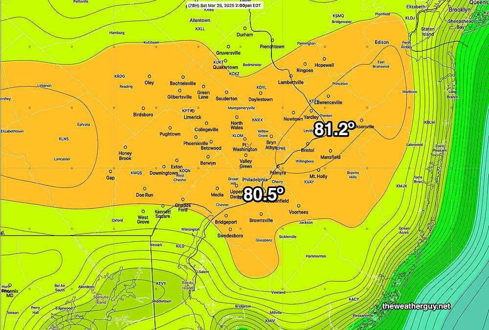
A warm front moves through Friday night and the ECMWF-AI-Single and Canadian RGEM models are still showing 80º+ for our area on Saturday.
ECMWF-AI forecast for Saturday at 2 PM. The Canadian RGEM shows even higher temps, although it tends to run warm. (Click on image for a larger view.)
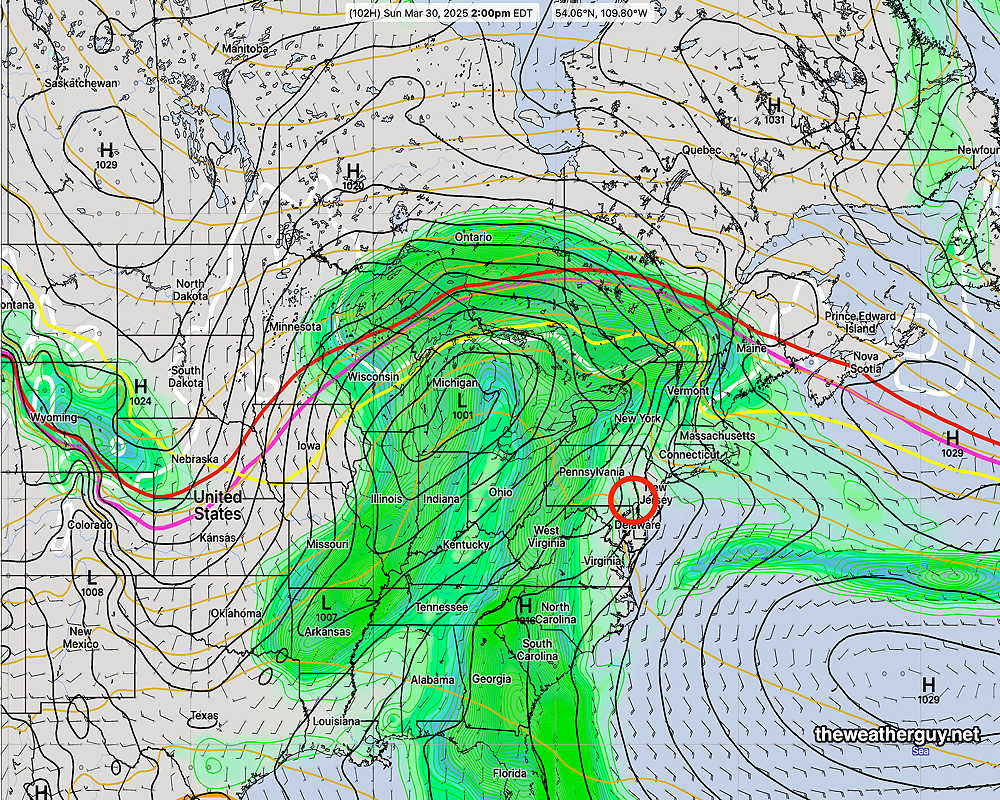
Rainy weather moves in late Sunday afternoon and continues through Monday. the Phillies opener may be affected.
ECMWF-AI Forecast for Sunday at 2 PM. (Click on image for a larger view.)
Wednesday Forecast Update
Posted Wednesday 03/26/25 @ 9:48 AM — Several models (ECMWF, Canadian RGEM, German ICON) are showing some fast moving instability showers moving through here early afternoon. There will be some sunshine in the [late] afternoon, according to the HRRR, but not as much as forecast yesterday. So clouds and some sprinkles is a better bet for late morning and early afternoon.
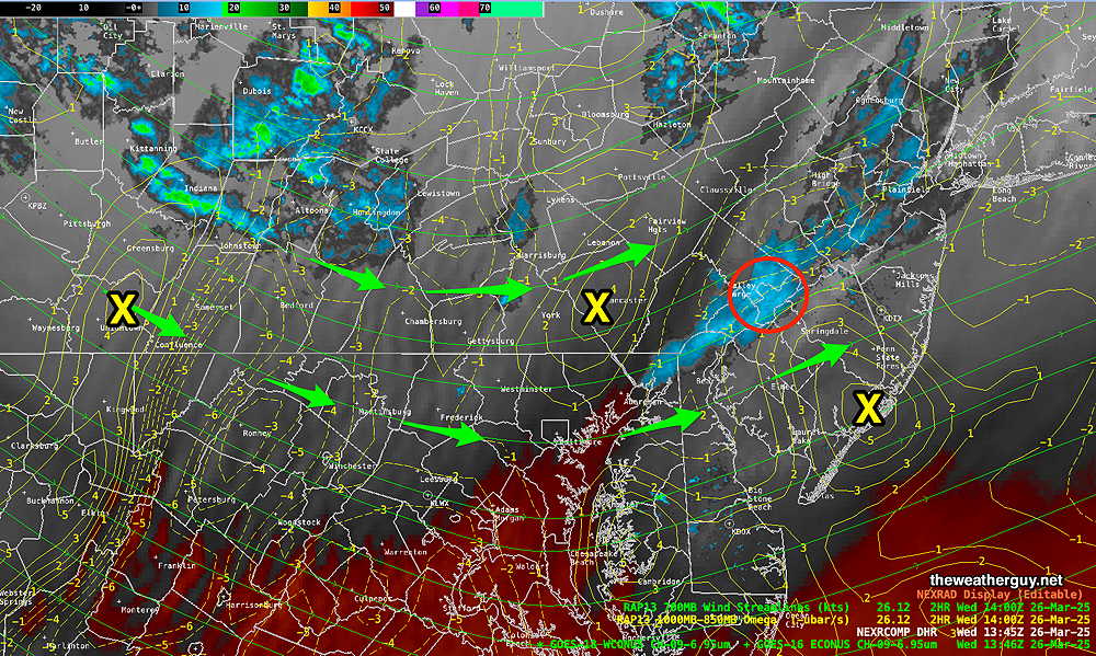
Current Water Vapor shows showers likely to pass to our north, but positive upward motion just to our west may produce showers here between noon and 1 PM and in NJ—
Current Water Vapor with RADAR and RAP Model low level Omega (upward motion) X denotes centers of upward motion leading to potential showers. (Click on image for a larger view.)
Wednesday through Saturday
Posted Tuesday 03/25/25 @ 6:04 PM — The fast moving low pressure system expected to form this evening will remain to our south. Rain may extend north into South Jersey, but the Philadelphia area will remain dry. Colder weather for Wednesday and Thursday with high temperatures around 50º with sunny skies. A warm up Friday. A big surprise for Saturday- high temperatures may approach 80º!
ECMWF-AI Temperature forecast for 2 PM Saturday! Contours are in 1º increments. (Click on image for a larger view.)
A rainy period develops Sunday into next Monday.
Winds Return for Tuesday
Posted Monday 03/24/25 @ 5:50 PM — Windy conditions, especially Tuesday morning, with gusts 25-30 mph. Highs return to about 57º-58º after a cold morning. Some clouds move in late afternoon.
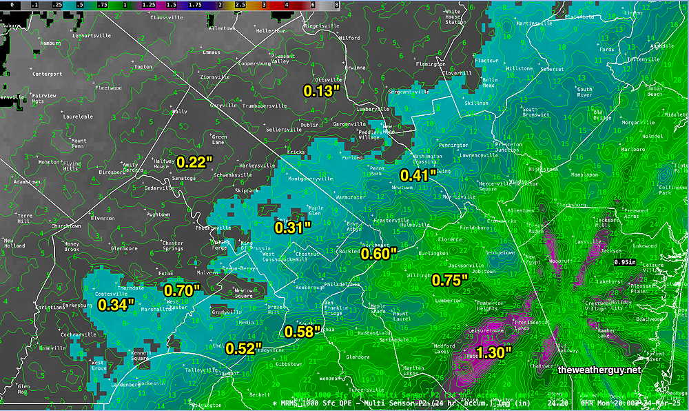
Mon 5:47 PM —Forecast Review — The rain ended about 4 PM and some sun is breaking out as I write this. Total rainfall, was somewhat higher than forecast in areas east of the city.
MRMS rain-gauge measured rainfall combined with rain-gauge calibrated and interpolated radar-based summary of ACTUAL RAINFALL RECEIVED. Color shading is in inches. Line contour numbers are in mm. (25.4 mm= 1 inch) It appears that there are some radar artifacts in this MRMS summary. (Click on image for a larger view.)
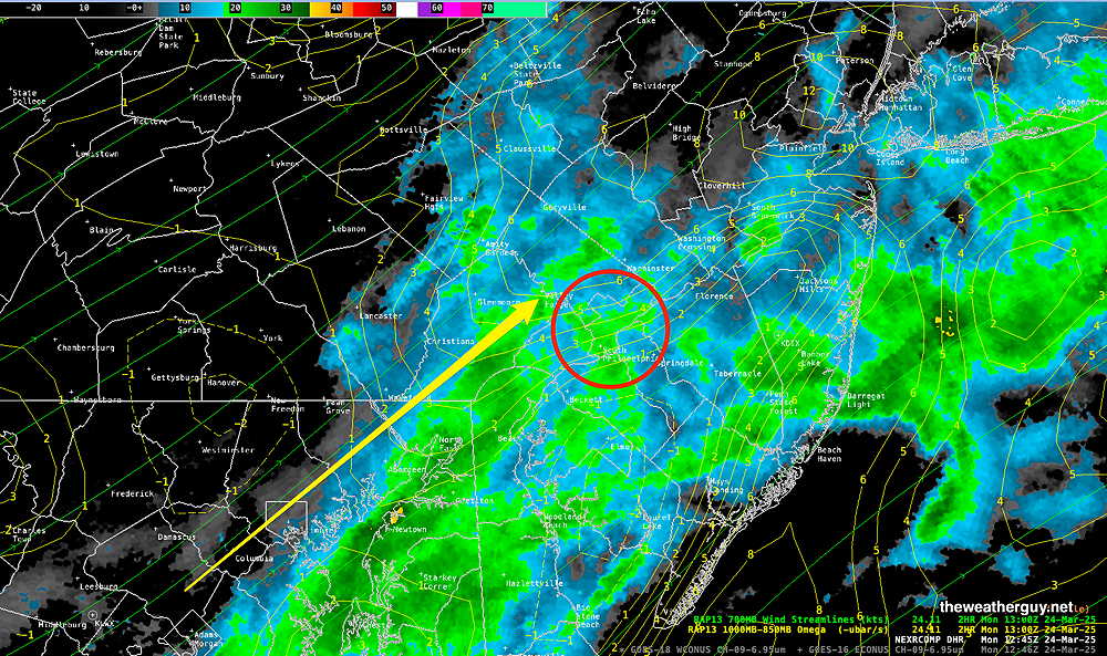
Posted Monday 03/24/25 @ 8:58 AM — Based on radar and the latest HRRR, the rain will be ending about 2 PM-3 PM around Philadelphia and about 5 PM to 6 PM at the Jersey Shore. (The Canadian RGEM has the rain ending about 3-4 PM here with some sun possibly by 6 PM. )
Radar at 8:50 AM with superimposed RAP mode low level Omega (vertical velocity pressure). Some enhancement of the rain this morning around Philadelphia is expected with positive Omega. The entire line is moving to the east with the storms moving to the northeast. (Click on image for a larger view.)
As for that potential ‘experiment’ with the ECMWF-AI model, its forecast for some rain here is now late Tuesday night, with light rain ending for the daytime Wednesday. The GFS has moved closer to the ECMWF-AI with some rain in NJ late Tuesday night.
Originally Posted Sun @ 4:25 PM — —Low pressure and an associated cold front will move through on Monday. Rainfall looks to be in the 0.45″ range, but several models have as much as 0.75″ of rain falling over our area. Rain starts before daybreak Monday and continues through at least 4 PM, when any remaining precipitation will become light and widely scattered.
Overall, this coming week looks to be colder than recent weeks with a persistent dip in the jet stream over the Central and Northeastern US.
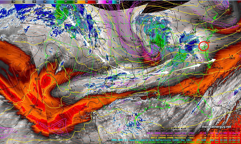
The current satellite water vapor image with superimposed RAP model parameters and MRMS radar shows the setup that will be persistent—
Current (Sunday afternoon) satellite water vapor image with superimposed RAP model 500-1000 mb thickness lines (yellow), Mean Sea Level Pressure isobars (black contours) potential vorticity (fine violet contours) with superimposed MRMS RADAR. A persistent dip in the jet (white arrows) will be with us for most of the week. (Click on image for a larger view.)
Of interest is the energy in the Pacific Northwest diving southward into the upper trough. The latest ECMWF-AI model shows another storm developing Wednesday which lends itself to another “AI model Experiment“.
Basically this AI model shows much more development of this Wednesday low pressure system than the either the GFS or ECMWF—
Wednesday forecast from the latest ECMWF-AI-Single model. Much greater storm development than either the GFS or ECMWF (Click on image for a larger view.)
Yet another system associated with a warm front approaches Friday or Saturday. Temperatures look to moderate by next weekend.
Fri 9:24 AM —Forecast Review — Last evening’s rain arrived within the time range given, but really about an hour or so later than I had expected. Total rainfall was somewhat on target, with much heavier rain than forecast eastern areas and in New Jersey.
Here’s the MRMS QPE (quantity of precipitation estimate)
MRMS rain-gauge measured rainfall combined with rain-gauge calibrated and interpolated radar-based summary of ACTUAL RAINFALL RECEIVED. Color shading is in inches. Line contour numbers are in mm. (25.4 mm= 1 inch) (Click on image for a larger view.)
Thursday Forecast Update
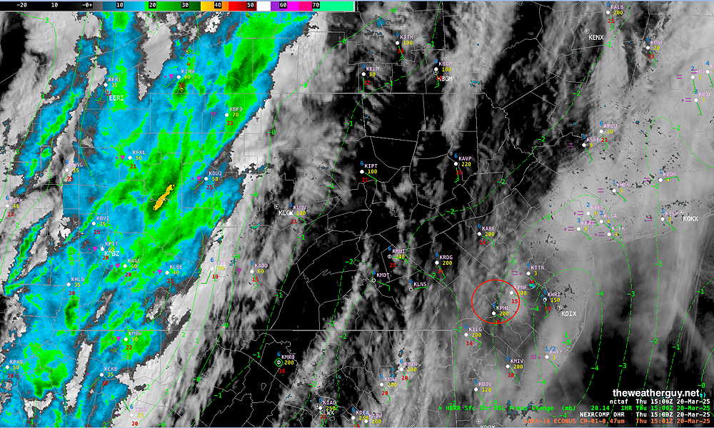
Posted Thursday 03/20/25 @ 11:04 AM — It looks like the breaks of sun will be in the morning. Increasingly cloudy in the afternoon.
Visible Satellite and Radar with HRRR 3 hour surface pressure delta. Notice the area of negative pressure delta just east of Philadelphia. Low pressure will form in this area. (Click on image for a larger view.)
Posted Thursday 03/20/25 @ 8:42 AM —Today’s forecast mostly on-track. Low clouds this morning will give way to mid level cloudiness this afternoon. Some areas may see some sun for a period this afternoon, but most will remain cloudy. Showers and rain moves in from the west between 5:30 PM and 8 PM. Total rainfall this evening between 0.45″ and 0.70″ (western suburbs may receive the higher amount). Windy conditions later this afternoon and then again later tonight. The actual frontal passage may not have much in the way of winds.
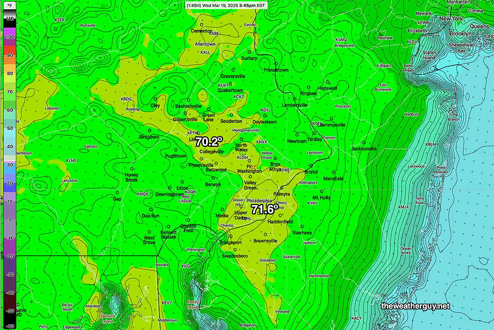
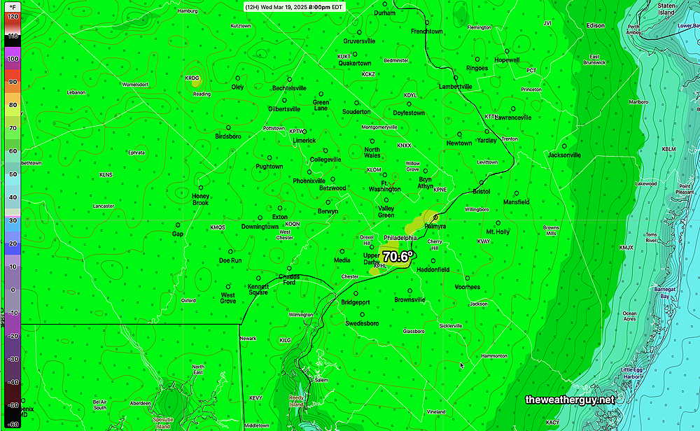
Posted Wednesday 03/19/25 @ 5:57 PM — The AI ‘experiment’ showed no winners, with the spatial and temporal resolution differences between the models over-shadowing any small differences in forecast high temperatures. That said, except for Center City, the NBM high temps were overall too low. Here’s the RTMA temps at 3:45 PM. the likely high temps for the day—
RTMA temperatures at 3:45 PM The RTMA records preliminary observed and interpolated temperatures at 15 minute intervals. (Click on image for a larger view.)
As for Thursday, a cold front (technically an ‘anafront’ type cold front, due to the rain following the frontal passage) will move across about 6 PM with showers and possible thunderstorms.
GFS forecast showing the ‘anafront’ type cold front. (Click on image for a larger view.)
Low clouds in the morning with mid-level cloudiness in the afternoon. Some breaks in the overcast possible just before the front moves across about 6 PM. Low pressure expected to form along the anafront, bringing more windy conditions. About 0.4-0.6″ of rain expected during the evening Thursday.
Yet Another AI Model ‘Experiment’
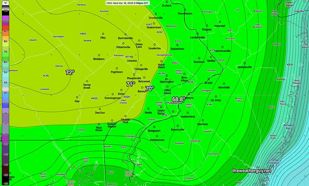
Posted Wednesday 03/19/25 @ 9:34 AM — There are differences today between the high resolution NBM model (our best model for temperatures) and the lower resolution ECMWF-AI-Single model regarding high temperatures for today.
The AI model has an easterly wind keeping temperatures from the city eastward below 70º, while large areas just west of the city are above 70º
ECMWF-AI-Single high temperatures at 2 PM. It should be noted that the AI model only forecasts on 6 hour increments, The high temperature will likely be reached at 3:00 PM or so, not 2 PM, so these temperatures may be a bit low. (Click on image for a larger view.)
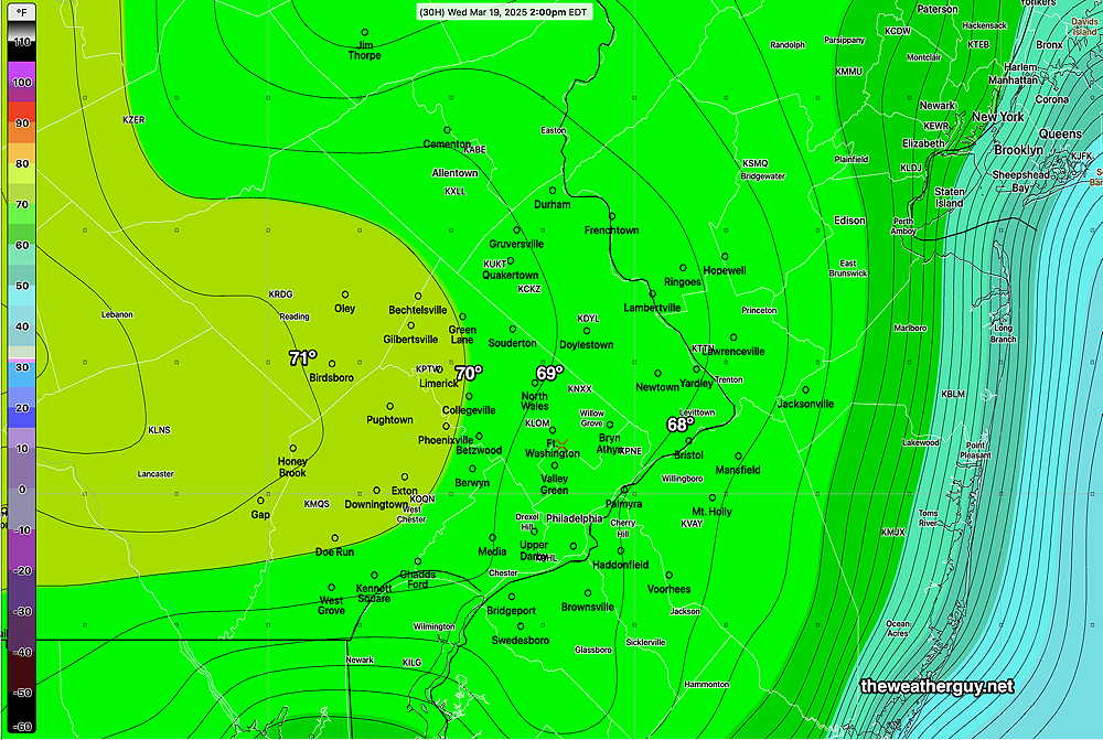
Here’s the latest 12z NBM model high temperature forecast for today—
The latest NBM shows most of the area just under 70º as a high. (Click on image for a larger view.)
An interesting and significant difference in the forecast. Either way, a very nice day, with some high thing cirrus clouds moving in about 3 PM.
Thursday will likely have rain moving in between 3PM and 6 PM ahead of a cold front. Some ‘interesting’ weather possible.
Wednesday through Thursday Outlook
Posted Tuesday 03/18/25 @ 5:34 PM — Wednesday promises to be a spectacular day, with mild temperatures just short of 70º. Sunshine in the afternoon will be through some thin cirrus clouds as moisture and milder air move in aloft ahead of a cold front expected late Thursday.
ECMWF-AI Single forecast high temperatures at 2 PM. Lately, this AI model has been more accurate than the NBM regarding high temperatures. (Click on image for a larger view.)
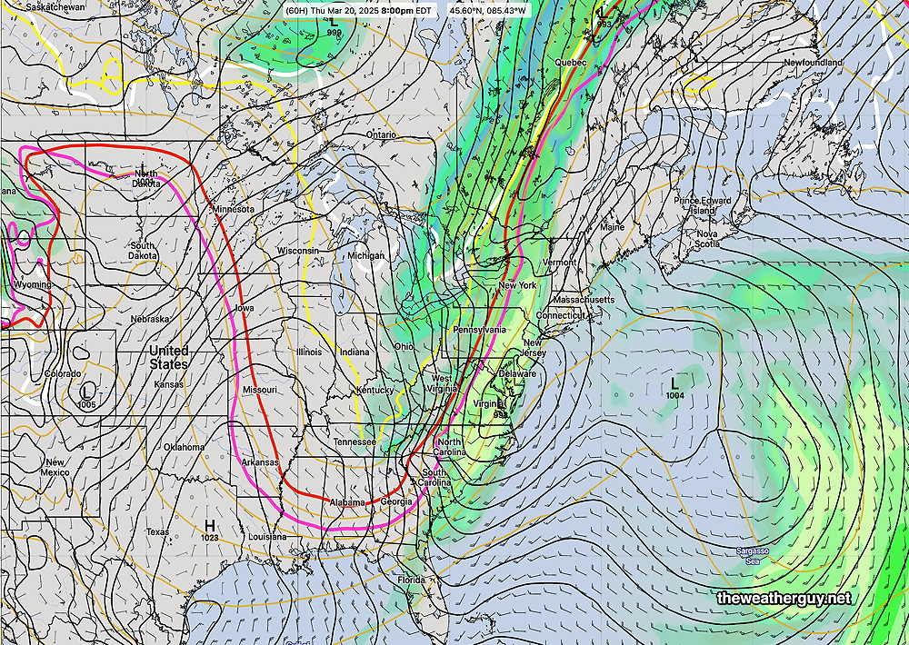
A strong cold front approaches on Thursday with some rain/showers moving in by mid to late afternoon—
ECMWF-AI-Single forecast for 8 PM Thursday. Advancing cold front with low pressure forming on the front. Much convective activity (yellow green color) (Click on image for a larger view.)
About 0.5″ of rain is expected with this system.
Originally Posted Mon 8:04 AM —Some rain is still falling at the Jersey Shore and there’s a chance of a light shower this morning, especially east into NJ.
RADAR 8 AM Monday morning. (Click on image for a larger view.)
Clouds should break for some sun around noon or early afternoon.
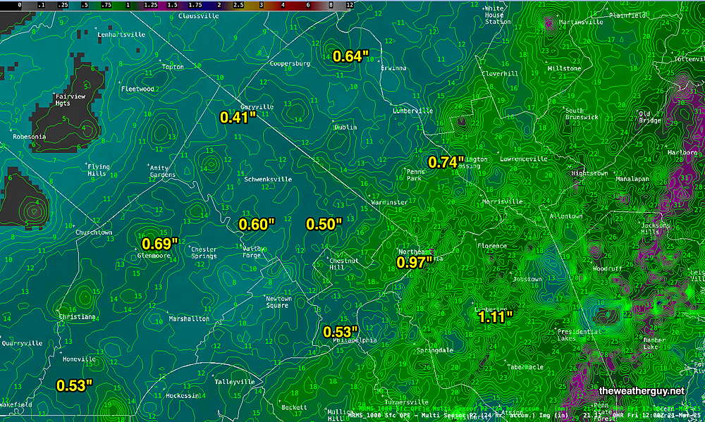
The rain occurred later than forecast, the strong wind gusts preceded the rain. Many areas did eventually receive the 1+ inch forecast —
MRMS (Pass 2) rain-gauge measured rainfall combined with rain-gauge calibrated and interpolated radar-based summary of ACTUAL RAINFALL RECEIVED. Color shading is in inches. Line contour numbers are in mm. (25.4 mm= 1 inch) (Click on image for a larger view.)
Our next chance for rain is late Thursday into Thursday night with a system somewhat similar to Sunday’s cold front passage.