Update Wed 05/03 @ 9:37 AM —The blocked pattern will slowly transform into another blocked pattern over the weekend. By the weekend, our part of the country will be under more of an upper ridge than the current upper low. Until that time we’ll continue with unsettled weather: clouds, some sun, scattered showers, and cool temperatures.
Today, Wednesday, we’ll likely have the most widespread shower activity, but both Thursday and Friday may have a few late afternoon showers in some areas.
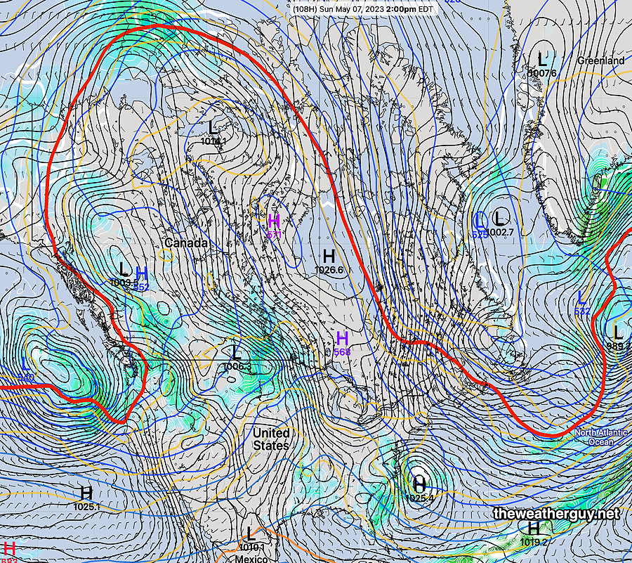
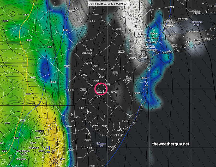
Here’s what things look like by Sunday—
NAEFS forecast for Sunday at 2 PM. The red line, (540 thickness line) captures the general configuration of the jet stream. Notice the extreme extent into northern Canada indicative of a blocked pattern. The Northeastern US will now be under more of the upper ridge. The weather should become drier and milder. (Click on image for a larger view.)
Tuesday – Continued Unsettled Weather
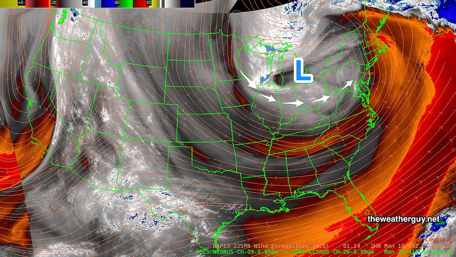
Update Tue 05/02 @ 8:16 AM — The upper air low has moved to north of NY State and it is expected to precess and end up over our area Wednesday and Thursday.
Disturbances continue to rotate around the upper low and one is bringing light showers this morning. Another is expected to move in this afternoon with more widespread showers.
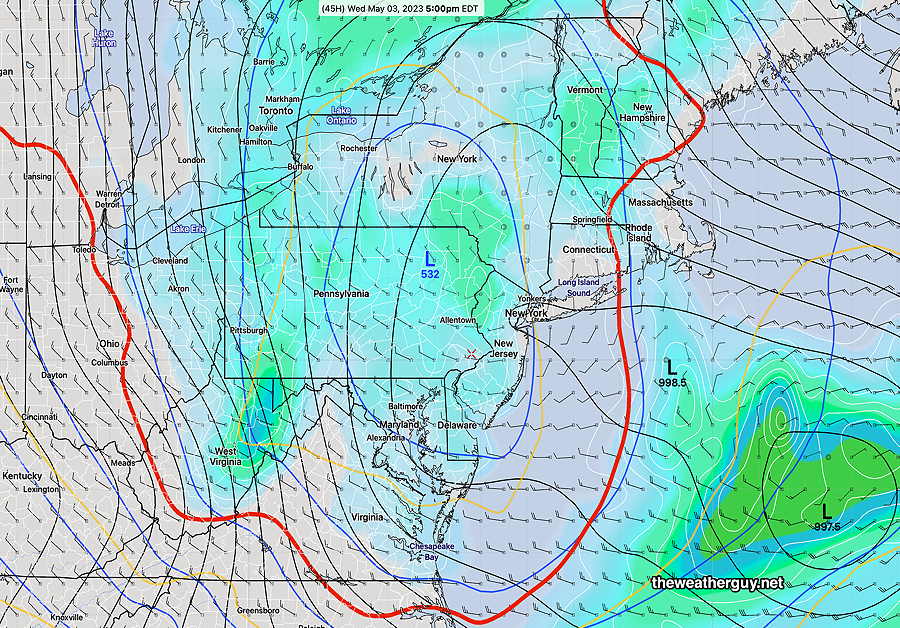
By Wednesday, the upper low is over Pennsylvania—
NAEFS for Wednesday at 5 PM. Notice the RED 540 thickness line. The 540 thickness line is usually most visible on weather maps in winter. Its appearance shows the pool of very cold air aloft associated with this upper low. This cold air aloft is resulting in instability cloudiness and showers. (Click on image for a larger view.)
Update Mon 05/01 @ 8:53 PM— The blocked pattern will remain with us through the weekend. The upper low pressure system over the Great Lakes has closed off and it will slowly move directly over Pennsylvania over the next several days. Unsettled conditions with periods of cloudiness and occasional showers expected.
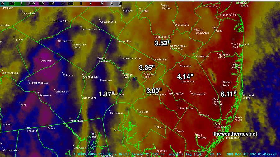
That was a lot of rain!
Woo! That was a lot of rain we got this past weekend! So how much did we get? Here’s the MRMS radar/rain gauge based measurement—
MRMS 72 hour rain total for this past weekend. (Click on image for a larger view.)
Previously Posted Mon 12:00 PM —
This Week’s Weather Overview
The blocked pattern will slowly loosen over the next several days. The upper low still over the Great Lakes will continue to rotate disturbances over our area, giving us periods of clouds and some showers intermixed with some sun.
Water Vapor Satellite image Monday morning shows the low pressure system still over the Great Lakes, rotating disturbances over our area. This may continue through Thursday. (Click on image for a larger view.)
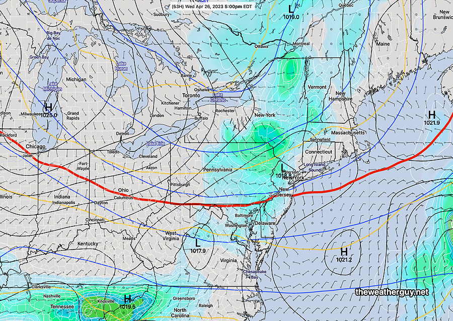
Update Wed 04/26 @ 9:48 AM — Some showers are moving in a bit earlier than forecast by most of last night’s models (with the exception of yesterday’s NAM-NEST). Additional scattered showers expected especially mid to late afternoon and evening. There will be breaks of sun at times today.
(It’s interesting that the two most recent NAM-NEST model runs did not show the showers this morning, but yesterday’s 18z run did. Such is the state of precipitation forecasts.)
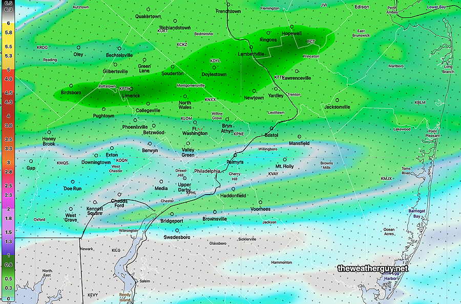
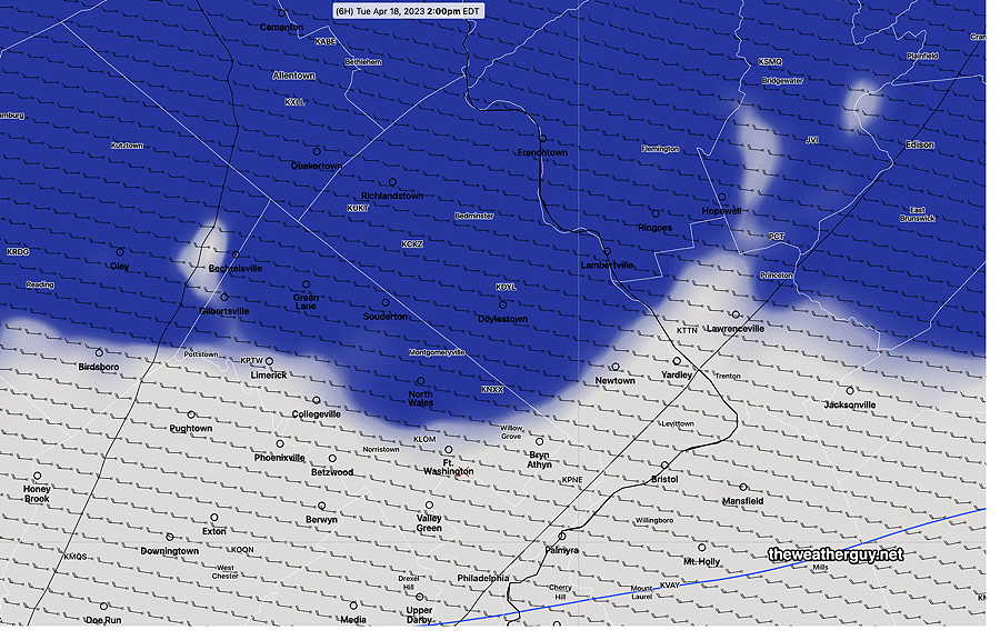
According to the latest HRRR (12z) most of the showers will develop during the late afternoon and evening and most of the activity (not all) will be a bit north of the city—
Today’s 12z HRRR total precipitation forecast for Wednesday into Thursday. (Click on image for a larger view.)
Wednesday Forecast Update
Update Tue 4/25 8:28 PM — No significant change in the forecast from the forecast made this morning (below). Inspection of this afternoon’s models suggests that a warm front type situation will be part of the trigger for the showers Wednesday. The showers will be scattered and there may be breaks of sun with any showers. Any sunshine will increase instability promoting the possibility of low level thundershowers.
It still looks like plenty of rain this weekend, as early as Friday, but there are timing differences now between the GFS and the ECMWF. So it may rain Saturday or Sunday or both days. Or some of the rain may be late Sunday, with rain-free periods during the daytime. Too soon to nail that down.
Update Tue 04/25 @ 10:14 AM — It does appear that some scattered showers and low-level thundershowers will develop during Wednesday afternoon. Clouds move in late morning and showers/thundershowers can be expected from about 1 PM to 8 PM.
The scattered showers will develop dynamically in-place, rather than moving in from the west as a upper air wave moves through.
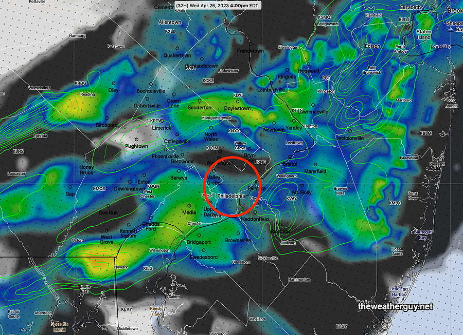
Here’s the latest HRRR cloud/radar forecast—
Today’s 12z HRRR forecast for 4 PM Wednesday afternoon. Clouds (dark) simulated radar and accumulated precip (green contours) (Click on image for a larger view.)
FYI, the models continue to forecast a fairly rainy weekend, now including Saturday and Sunday. Updates later.
Focus on Wednesday and after
Update Mon 4/24 10:27 PM — This afternoon’s models still have some showers on Wednesday but the timing ranges from starting in the early afternoon or early evening in our immediate area.
This weekend’s weather still looks very ‘interesting’ as heavy rain is looking more likely on Sunday from a stalled surface low enhanced by a highly amplified jet flow. Unsettled weather is possible late Friday and even some part of Saturday from the same system.
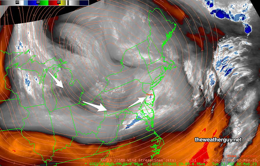
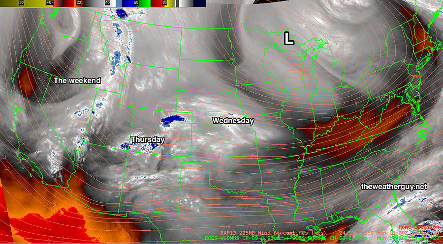
Update Mon 04/24 @ 8:57 AM — Last night’s models are signaling a change in the forecast as early as Wednesday. An upper air low pressure system north of the Great Lakes will rotate a disturbance through our area on Wednesday —
Satellite WV image Monday morning with superimposed RAP model jet level windstreams (250mb) . (Click on image for a larger view.)
Here’s the latest NAEFS forecast for Wednesday showing weak low pressure over us—
Today’s 06z NAEFS (Click on image for a larger view.)
The disturbance is weak, but enough to set off some showers on Wednesday. So what appeared to be a quiet few day of weather has changed into something less straightforward.
Today, Monday, and Tuesday will be the nicest days of this week. (Today will have some periods instability cloudiness develop in the afternoon.)
Additional disturbances and a developing trough (labeled “The weekend” above) will affect us Thursday through the weekend.
Quiet and Cooler
Previously Posted Sun 6:50 PM —
An upper air disturbance brought some clouds late today, Sunday, after a beautiful, mostly sunny day in the immediate PHL area. Areas east of us in NJ had some lingering clouds from the system that gave us the rain last night.
Following this disturbance, cooler air will be moving in for much of the first half of this week. Not much happening Monday through Wednesday, as high pressure and cool temperatures control our weather. Mostly sunny, some instability cloudiness at times.
We may get affected by a disturbance moving to our south on Thursday, with a chance of some showers.
Things look ‘interesting’ for next weekend. A highly amplified upper trough will develop and the models are showing a coastal secondary low that may develop and linger. There’s fairly good agreement among the ECMWF and GEFS models for this to occur. Cool, breezt and very rainy weather is expected. The time frame, depending on the model, is as early as Saturday, possibly lingering through part of Monday. I’ll keep an eye on this during the week.
Here’s the current NAEFS forecast for next Sunday—
Today’s 12z NAEFS forecast for next Sunday. Cold air plunges south. The red 540 thickness line captures the general contour of the jet stream. Secondary low formation in the Virginias may linger as the upper pattern takes on a negative tilt. (Click on image for a larger view.)
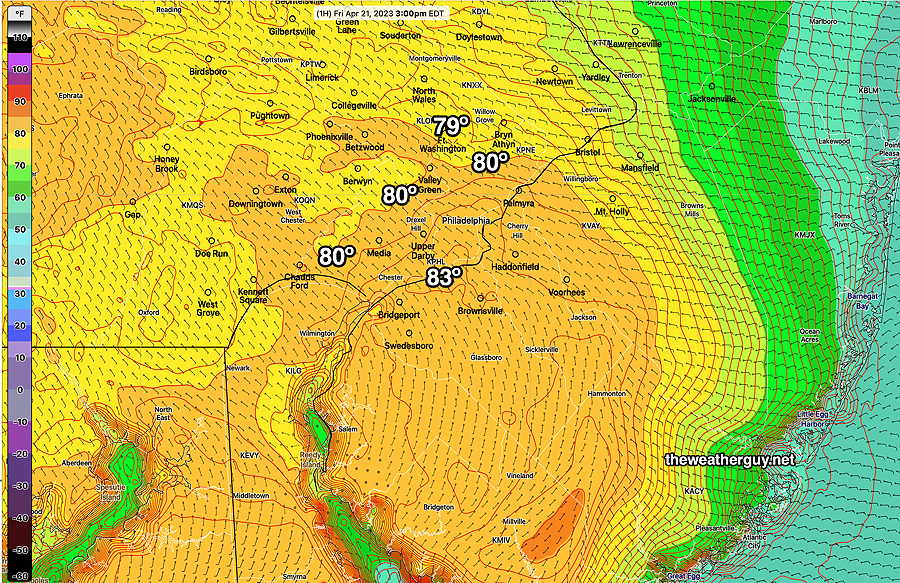
Fri 5:45 PM Forecast Review — The weather’s been nice and beautiful and so the focus has been on the uncertainty in high temperatures for today. It took awhile for things to warm up to the 80s.
Here’s the RTMA for 3 PM showing the preliminary observed high temperatures for the day—
Today’s 3PM RTMA showing preliminary high temps for today. This morning’s NBM was very close to what was observed.
Friday Forecast Update
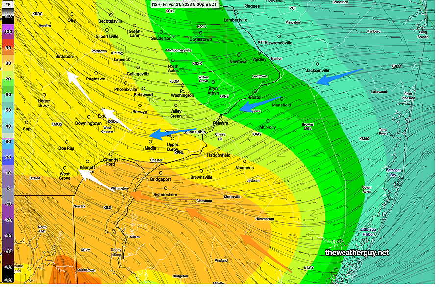
Update Fri 04/21 @ 8:22 AM —Large differences remain with the forecast high temperature today. The reason for these forecast temperature differences are slight differences in the origin of the forecast surface wind flow.
The latest RAP model wind streamlines captures the differences: where the easterly flow originates from the northeast, it will be cooler. Where the easterly flow originates from the southeast, it will be warmer—
RAP 09z model. Follow the easterly windstream origin and the reason for the differences in the high temp for today becomes apparent. (Click on image for a larger view.)
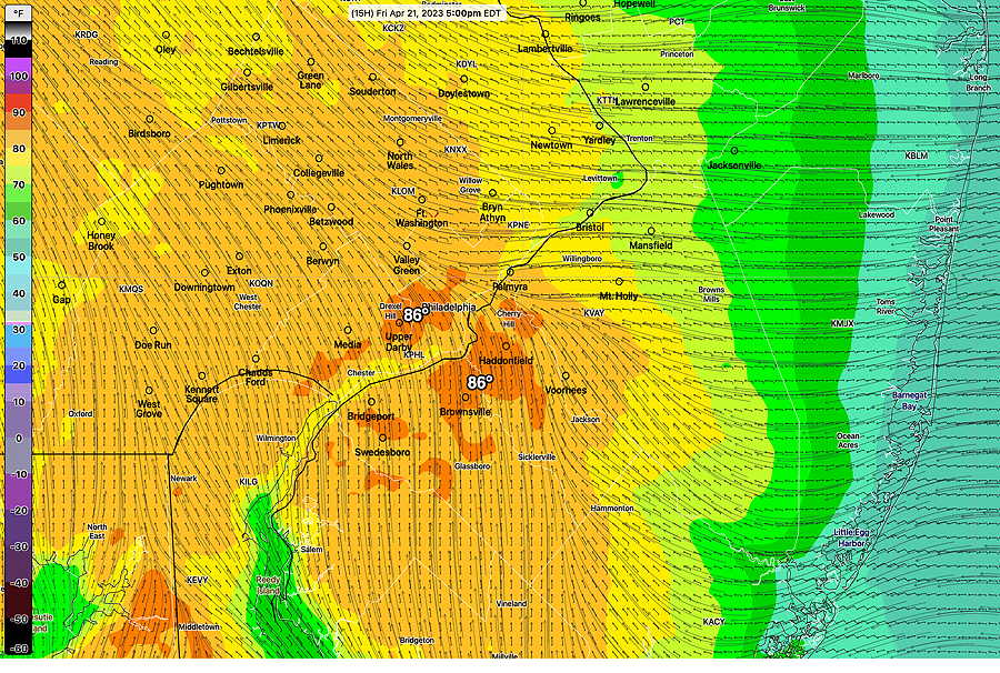
In contrast to the much cooler RAP model forecast, the Canadian high resolution model (HRDPS) forecasts temperature much higher for us today—
Today’s HRDPS shows much higher temperatures due to a more southerly wind component forecast. It should be noted that the HRDPS temperature forecasts have ALL been too high for us this season so far. (Click on image for a larger view.)
The NBM model blend is right in the middle of the two forecasts above—
07z NBM high temp for Friday (Click on image for a larger view.)
For Saturday, the rain moves in between 5PM and 7 PM. Details in the regular “Weekend Weather Forecast” later tody.
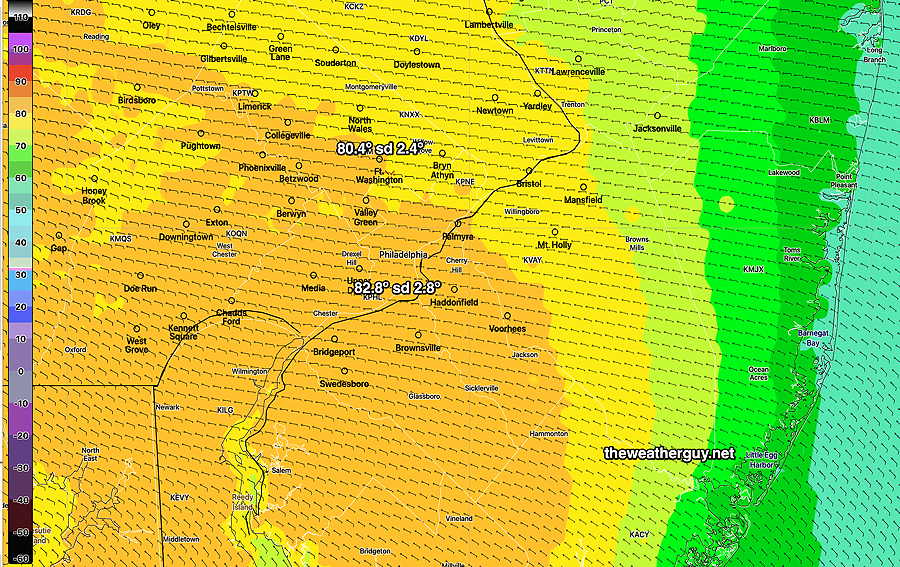
Update Thu 4/20 @ 7:55 PM — Friday is going to be another beautiful day. There has been a reduction in the high temperature forecast for Friday, as expected from last night’s forecasts.
Previous days this week, highs of 85º looked like a certainty for Friday. The latest GFS has reduced its high to about 82º for Friday, while the high resolution mesoscale models (HRRR, NAM-NEST, HREF) have us only in the mid 70s tomorrow.
Not surprisingly, the NBM is forecasting about 80º (with a high standard deviation of about 3.5º). That’s still a high level of uncertainty for next day temperatures. (As usual, my temperatures refer to location Wings Field, Blue Bell, PA.)
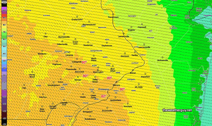
Here’s the latest NBM high temps—
Today’s 19z NBM high temperatures for Friday. (Click on image for a larger view.)
As for Saturday, the forecast is for the rain to move in about 6 PM or so.
Huge High Temperature Uncertainty Friday
Update Thu 4/20 8:01 AM — Last night’s models continue with an incredibly large spread in high temperatures for Friday, due to the uncertainty of the easterly wind flow and possibly some low level clouds.
The HRRR and RAP keep us in the low to mid 70s as a high, while the global models (GFS) are in the low to mid 80s! The NBM model captures this — its high temperature standard deviation is almost 6º. That means that of the approximately 40 models that the NBM statistically weights, there’s a range of ± 6º in the forecast highs of 67% of the models. It also means that 33% of the models have even larger differences.
(Typical standard deviation in the NBM high temperature a day in advance is about 1-2º!)
This all boils down to high uncertainty in the forecast high for Friday.
I wouldn’t mind some wonderful 80º temperatures, but I’m leaning towards betting on the lower end of the range right now.
Update Wed 4/19 10:59 PM — Possible big change in the Friday forecast. Tonight’s NAM-NEST shows an easterly wind flow with much cooler temperatures. Just one model, but don’t be surprised if Friday is much cooler than forecast earlier.
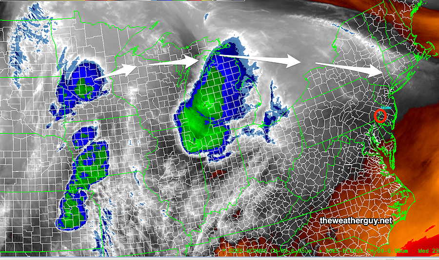
Update Wed 04/19 @ 7:53 PM — A strong upper air ridge will be in place over us for the next few days.
For Thursday, we”ll get into the mid to upper 70s and there may be some high thin cirrus cloudiness at times as moisture move up along the upper air ridge.
Current Satellite Water Vapor. The arrows show the path of the disturbances moving far north of us on Thursday—
Temperatures will continue to warm and Friday will be very warm for April.
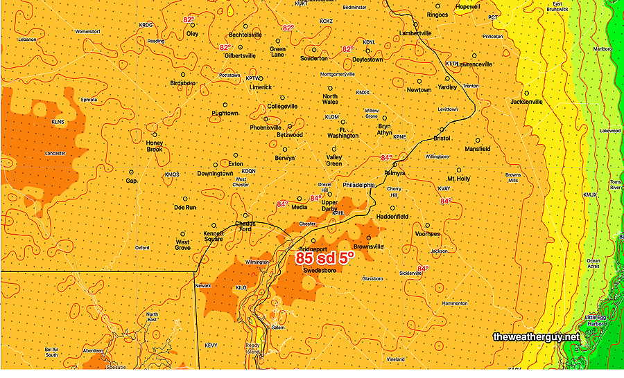
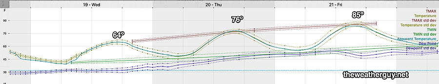
Friday’s forecast high temperatures—
Latest NBM model high temperature forecast for Friday. Temperatures in and around the city are predicted to reach near 85º but there’s a verylarge spread (standard deviation of 4º- 5º) among the models indicating high uncertainty. So while 85º is the mean temperature, it could be higher and it could be lower by as much as 4º-5º (Click on image for a larger view.)
The forecast for the weekend is clarifying. A strong cold front moves through Saturday night with some possibly moderate to heavy rain. It looks like the precipitation moves in about 4-7PM.
The latest GFS model has rain just entering the western suburbs at 6 PM Saturday. (Click on image for a larger view.)
It should clear out for Sunday with much cooler weather.
Wednesday thru Friday
Update Tue 04/18 @ 5:35 PM — We had less cloudiness and higher temperatures Tuesday than forecast yesterday. I might add less wind as well. The clouds were mostly north of Quakertown
Wednesday through Friday looks good with warming temperatures. A few upper air disturbances on Thursday may bring a mix of clouds and sun. Friday looks even nicer and much warmer.
Temperatures will become summer-like again by Friday!
NBM (19z) forecast temperature/dew point with standard deviations meteogram for Blue Bell PA (Wings Field). Mean High temperatures shown. (Click on image for a larger view.)
The forecast for the weekend is in flux. The ECMWF has the cold front with shower/storms late Saturday. The GFS is slower and has the showers/storms into Sunday.
Tuesday Forecast Update
Update Tue 04/18 @ 12:01 PM — This morning’s models have backed off on the clouds for today with the exception of areas north of the city.
HRRR low level cloud forecast for 2 PM Tuesday. (Click on image for a larger view.)
Update Mon 04/17 @ 6:10 PM — The secondary cold front moved through late this afternoon with just some clouds. Colder air is moving in and will be with us through part of Wednesday.
Tuesday will be relatively chilly compared to recent days. Highs will be in the mid 50s. It will be windy and there will be a fair amount of instability cloudiness developing late morning through much of the afternoon, especially in areas from the city northward.
More sun on Wednesday, still windy. Temperatures will return to the 70s on Thursday. Friday looks good.
Weekend Early Outlook- part of the weekend (likely Sunday) looks to be quite interesting as heavy rain and thunderstorms as surface low pressure develops along a strong cold front.
Previously Posted Sun 8:53 PM —
A cold front moves through Sunday night about 1 AM with light scattered showers. No severe weather. Cooler air filters in on Monday,
Clouds linger Monday morning, then sunshine from about 10 to 3 PM.
Additional cloudiness with a secondary cold front late afternoon. Colder air for Monday night and Tuesday and quite windy. Very windy Wednesday. (Average seasonal high is about 65º-66º)
Moderating temperatures by Thursday.
(Next weekend looks a bit wet.)
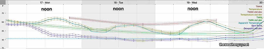
Here’s the latest NBM temperature meteogram for Blue Bell, PA for Monday through Wednesday—
NBM Meteogram Temperature Dew point Max Temp with standard deviation (Click on image for a larger view.)