Category Archives: Philadelphia Area Weather Forecasts

WEEKEND WEATHER FORECAST

Sun @ 7:53 AM— My home security camera showed a dusting of snow on cars about 2 AM.

Here’s an update to my original Sunday forecast

For today, Sunday, clouds should break for a period of sunshine about mid-day. As has been the case recently, there’s quite a bit of model statistical spread regarding the amount of cloudiness, but I’ll go with the optimistic NBM mean cloud cover. Clouds return later in the afternoon and winds pick up and become gusty. High 49 (Blue Bell) 51 (PHL)

Another series of windy, cold days the beginning of this upcoming week.


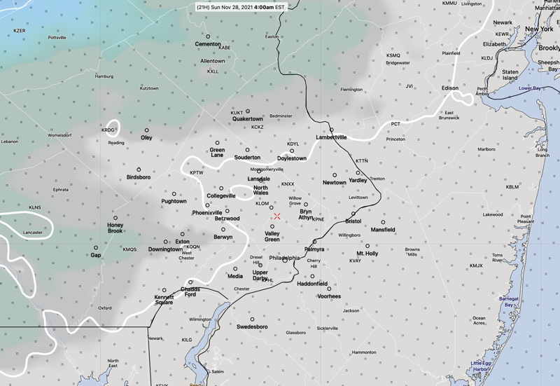
Sat @ 6:50 PM— Tonight’s GFS has no snow falling tonight in the immediate PHL area. However there are several models (SREF, HRRR, NBM, Canadian GEM) that have light snow flurries/snow showers moving through around midnight through 3 AM.

Temperatures today did not warm up to levels predicted by last night’s models and current temperatures are a few degrees colder than current models are forecasting.

Assuming temps are a bit colder tonight, areas just north of the city may see a dusting/coating of snow at daybreak. These are the areas with possible accumulation—

Canadian GEM Regional snow accumulation forecast. (White area just north of Philadelphia is a dusting or less.) (Click on image for larger view.)

Sat @ 9:51 AM — This morning’s models show snow flurries between midnight and 3 AM, but without a dusting accumulation in the immediate PHL area. Minimal precip and temperatures at the surface have trended warmer in the models.

NAM-NEST forecast for 4 AM Sunday showing 32º line (white line) is north of PHL and dusting accumulation possible north of Quakertown and west of HoneyBrook. (Click on image for a larger view.)

Fri 10:03 PM— Tonight’s short range models have snow flurries after midnight Saturday into predawn Sunday. A dusting of snow is possible.


Initial Post Discussion—[post_published]

The strong pressure gradient that gave us the blustery winds today will gradually reduce as low pressure moves off to the northeast and high pressure builds in for Saturday.

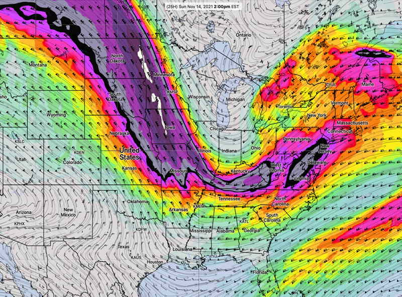
Another low in the Great Lakes area will transfer its energy to a low pressure system that develops near Long Island on Sunday.

GFS forecast for Sunday 6 AM. (Click on image for a larger view.)

Most models have the main Great Lakes low weakening so as to have no precipitation for us. Some statistical model members show just enough lift and moisture for some light snow flurries after midnight Saturday.

It will be colder than season averages. (Seasonal average high temps are 49º-50º)

Saturday

It will be sunny and windy. Less windy than Friday. The pressure gradient causing the winds will lessen and the gusty winds will diminish during the afternoon. High Temps 41.8º ± 1.7º (NBM model Blue Bell)

After midnight Saturday into the predawn hours of Sunday, there’s a chance of light snow flurries.

Cloudy early. Sunday will become partly sunny/partly cloudy. Light winds early, but increase in the afternoon. Temperatures reach their highs late in the day. High temps 46.0º ± 1.5º (NBM model Blue Bell)

A cold front moves through Sunday night with winds increasing for Monday.
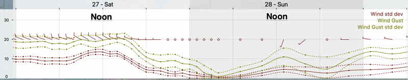
Winds
NBM (Click on image for a larger view.)

WEEKEND WEATHER FORECAST

Update Sun @ 9:05 AM — Simple But Interesting— Following yesterday’s poor model cloud forecast, I wanted to get some better model data indicating the uncertainty in the model’s cloud forecast. The HREF model includes “statistical spread” data as a download parameter option. Here’s this morning’s HREF total cloud cover forecast for 11 AM Sunday—

HREF 06z model total cloud forecast for 11 AM Sunday. Dark is mean cloud cover, red contours are areas of high statistical spread, green/blue is rain. Notice that the red contours (high statistical spread) are centered over the PHL area at 11 AM, indicating that the group of models that make up the HREF have a wide range of cloud forecasts. While the mean (average) cloud cover is low (~ 40%) in PHL at 11 AM, the uncertainty in the cloud cover (spread) at 11 AM is is ± 35%!

I’m staying with the forecast update below from 9:21 PM last night.


Update Sat @ 9:21 PM — Reviewing this afternoon’s models and the early models available this evening,  Sunday morning and the early afternoon is looking sunnier than previously forecast.  As a result, the high temp will be about 54º.  

Increasingly cloudy between 2 and 4 PM.  The NAM-NEST has some light showers as early as 6-7 PM.


[note note_color=”#bceaed” text_color=”#333333″ radius=”3″]Sat 03:52 PM Forecast Review — Saturday was a beautiful day with more much more sunshine than forecast.

Most of this morning’s models showed 100% mid-level clouds by noon; clearly not correct.

I usually prefer the GFS for cloud cover, especially when the humidity parameters back up the cloud cover forecast.  But the GFS didn’t come through for today.

Looking back at last night’s models, the NAM-NEST had the best forecast, but it’s not a model I would have chosen to predict today’s cloud cover. 

With Saturday’s forecast incorrect, I will be checking tonight’s models to update Sunday’s forecast later.[/note]

Initial Post Discussion—[post_published]

A cold front went through Thursday night and high pressure moved in for Friday and expected to linger for some of Saturday. The high pressure system will move off the coast Saturday. A warm front will move in Saturday and another strong cold front moves in late Sunday. Windy Sunday evening ahead of this jet dip.

The cold front later Sunday will be propelled by an outbreak of cold air, pushing the jet stream into a highly amplified pattern for Monday and Tuesday—

GFS forecast jet stream level (300 mb) for Monday at 10 PM showing a highly amplified pattern. . The mulit-colored areas are 300 mb wind speeds and the highest winds are the ‘jet streaks’. (Click on image for a larger view.)

This upper air configuration causes low pressure development. This development will occur east of our area. A similar type of configuration, slightly west in winter, might cause a significant snow storm for the coast. Not this time.

Saturday

As high pressure departs, winds will shift to southeasterly as a warm front approaches. After some sunshine in the morning, considerable mid-level (altocumulus/altostratus) cloudiness develops by noontime and continues through the rest of the afternoon.

Update Fri @ 11:06 PM — Tonight’s high resolution models show a few more breaks of sunshine on Saturday than the earlier GFS that the above forecast is based on.

High temperature 48º ± 1.1º NBM (model blend) Blue Bell, PA

The warm front attempts to move north while a very strong cold front approaches from the west ahead of the dip of the jet stream (in the above graphic).

Clouds early, then many models show some late morning to early afternoon sunny breaks, but clouds return to become cloudy as showers approach from the west for later in the day.

Update Fri @ 5:36 PM — Friday afternoon’s GFS shows significant cloudiness, very little sunshine for Sunday.

Windy conditions develop during the evening and nighttime.

High temperature 50.1º ± 2.0º NBM (model blend) Blue Bell, PA

GFS mid-level cloud (maroon shading) AND simulated radar forecast for Sunday, 4 PM. (Click on image for a larger view.)

The GFS has some light showers/sprinkles by early evening in western suburbs. HIGH WINDS. Windy SUNDAY EVENING AND NIGHT ahead of the front.

WEEKEND WEATHER FORECAST

Update Sun 11:50 AM — Several models have a few hours of sunshine mid afternoon on Sunday.


Update Sat @ 5:53 PM — The cold front came through about 1:30 PM today, within the forecast range but a little later than Friday’s models had suggested.

As mentioned in the Sunday forecast, it still looks like Sunday will have considerable mid-level cloudiness develop during the morning with possible breaks of sunshine in the afternoon. The cloud cover will be mid-level clouds and suggest a winter-like day. A strong upper air disturbance will cause the cloudiness—

GFS Jet stream level forecast for 2 PM Sunday, Notice the jet streak just entering our area. The same active flow will bring another cold front through Monday. (Click on image for a larger view.)

Another front moves through Monday.


Update Fri 9:52 PM —Tonight’s models are coming in with lighter precipitation (< 0.10 “) on Saturday than the earlier GFS-based forecast. Timing 11:30 AM to 2 PM. WINDY. Remainder of forecast unchanged.


Initial Post Discussion—[post_published]

The GFS was ahead of the pack predicting the frontal passage today and the afternoon clearing. I’m going to lean towards the GFS for the weekend forecast. The weekend will will feature a cold front passage Saturday and much colder weather for Sunday.

GFS “simulated radar” forecast for 1 PM Saturday. (Click on image for a larger view.)

Saturday

A strong cold front will move through mid-day Saturday from about 11:30 AM through 1:30 PM. Temperatures fall rapidly after the frontal passage.

Clouds and winds will increase during the morning, and by about noon, showers will develop. The GFS and HIRESW-FV3, ICON and Canadian GEM models are predicting showers with the frontal passage.

However, the latest HRRR has the showers passing by to our north and some other models have negligible precipitation. I’m leaning towards the GFS which has 0.20 inches of rain falling.

Temperatures in the 50s in the morning will drop into the 40s by early afternoon and into the 30s by nightfall.

Sunday will be sunny in the early morning, but an upper air disturbance, moisture and instability will cause considerable cloudiness by late morning into the afternoon. Skies may break for sun at times in the afternoon. It will be cold. Breezy. Highs 48.1º ± 0.9º

Another cold front moves through on Monday!