Of course, Sunday morning is the beginning of Daylight Saving Time. I love the extra daylight at the end of the day, but for “weather nerds”, Daylight Saving Time means the models come out an hour later. For those of us on Eastern Time, the evening models become available inconveniently late for the next day’s forecasts!
I’ve written extensively about this in past years—
Little Known Facts about Daylight Saving Time and TV Weather Forecasts
Update Sat @ 9:53 PM —
Sunday
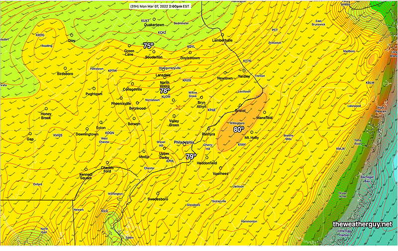
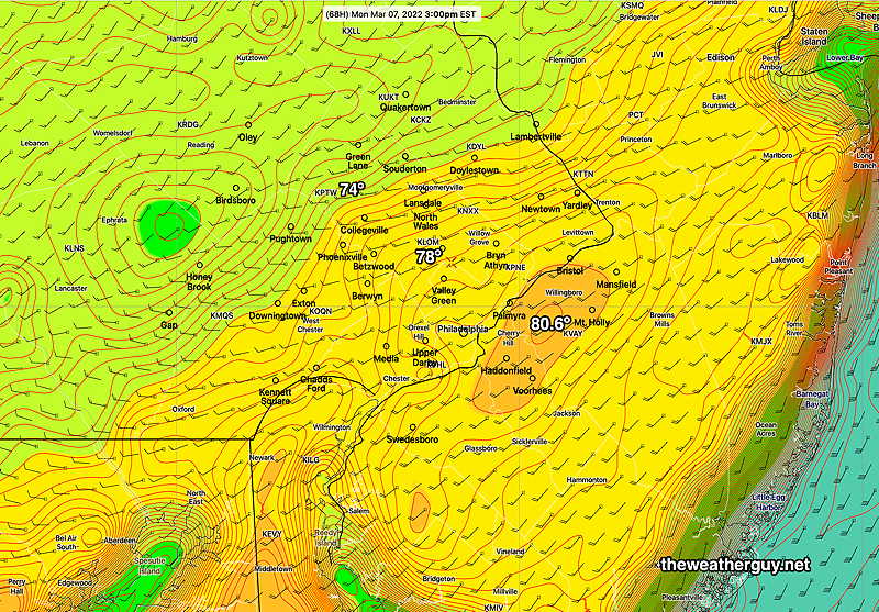
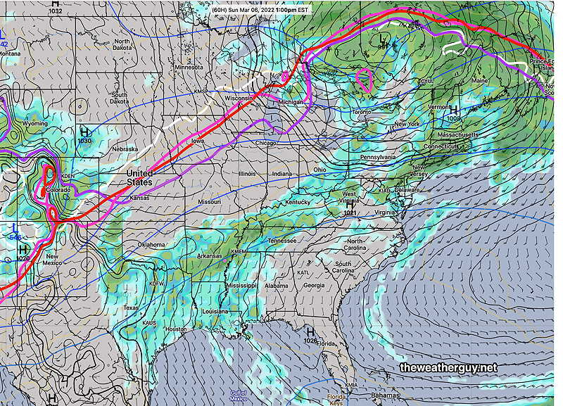
A cold sunny morning, with possibly a period of cloudiness mid morning, will give way to an upper air disturbance bringing considerable cloudiness mid afternoon Sunday. There’s a chance of a quick snow flurry late afternoon or evening.
It will remain unseasonably cold but less windy. High temperature 35º ± 1.7º
Show More
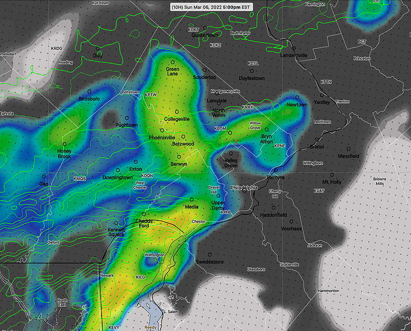
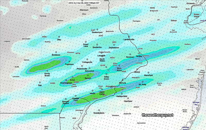
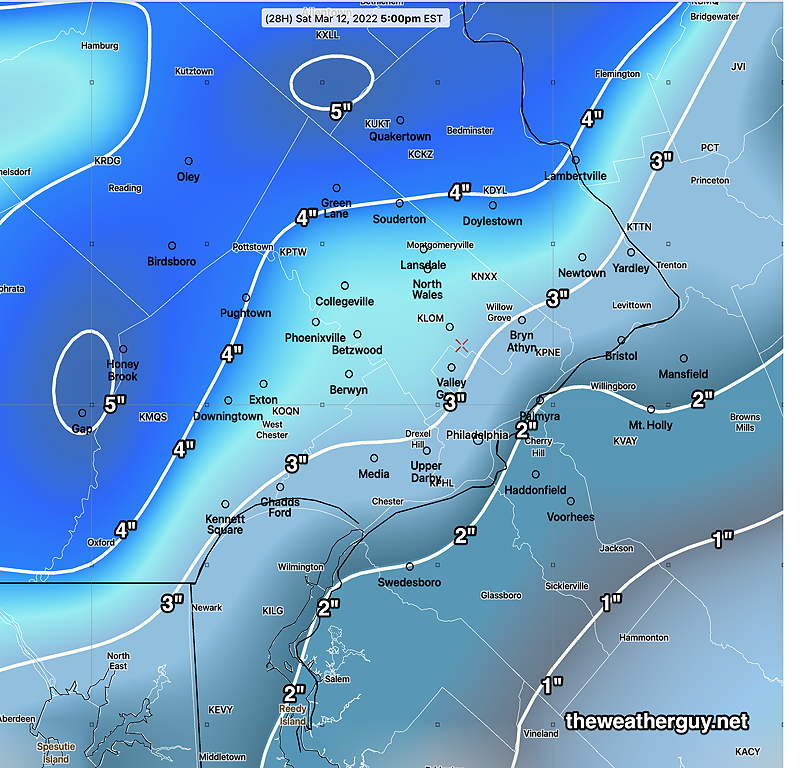
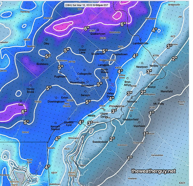
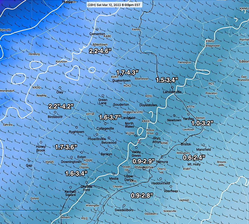
Update Sat @ 2:46 PM —Some flurries and snow squalls on the way. The latest HRRR shows possibly another inch of snow! Snowfall accumulation amounts have been at the lower end of the forecast range. Looking at yesterday’s models, the CMC-RGEM and German ICON had predicted the lower snowfall in the range we have received. Last night’s GFS/NAM/HRRR and HIRESW models over-predicted accumulation. The NBM forecast, which “blended” all of them, did pretty good, maybe a bit too high. Here’s official NWS snow totals— Update Sat @ 9:00 AM — The latest 12z NBM snow forecast— As of 9 AM, the precip is already changing to graupel (frozen melted snow) and the winds are picking up. Update Sat @ 7:28 AM — Last night’s 1AM model runs (06z) have moved towards the mid and lower end range of last night’s NBM forecast. The general range still looks good. Expect the winds to pick up dramatically with the temperature drop between 9 and 11 AM. Update Sat @ 7:01 AM — I removed an update made at 11:47 last night. ‘Never try to do weather forecasting in bed with an iPad’. Update Fri @ 10:16 PM — No significant changes with tonight’s models; the usual range of snow totals, similar to those posted earlier. Rain changes to snow between 8 AM (western suburbs) and 10 AM (just west of city) to 11 AM (Philadelphia) and tapers to flurries between 3 and 5 PM. Warm ground and March’s high solar angle will interfere with accumulations at start and likely reduce accumulations on roadways. There will be some compression of initial snow due to wetness. With temperatures dropping and water-snow ratios changing in time, I don’t know that any model algorithm will be able to accurately capture this event’s snow totals. That said, I’m turning it over to the NBM (model blend). With a two inch spread, I think the graphic below will do the best, but keep in mind that some models have much more and and a few have less— Previously Posted Fri 6:03 PM — The potential for a weekend storm was mentioned last Sunday and the evolution of the forecast for this storm has been ongoing with Wednesday’s post. The trend has been for an quicker and colder storm with rain turning to accumulating snow. While there had been little accumulation originally forecast, all of the models last night began showing some accumulation. Temperatures drop from 45º after midnight to below 32º by 9-10 AM, according the latest GFS. Today’s trend towards increasing snow totals has continued. The reason: increased forecast total precipitation, a faster moving storm and cold air entering as early as 9-10 AM in Philadelphia and 7-8 AM in western suburbs. That’s about 3 hours earlier than previously forecast last night. Forecast QPF is as high as 1-2 inches of water, compared to the previously forecast 0.6 inches. Part of the cooling allowing for the rapid transition to snow will be the result of a phenomenon known as dynamic cooling— heavy precipitation causes cold air to be brought down from the upper levels and phase changes and evaporative effects also chill down the atmosphere. Here’s the latest GFS snow totals — Here’s the latest NAM-NEST forecast — As is often the case, the NAM and NAM-NEST forecast higher amounts than the GFS. Often an average of the two is a good guesstimate. Sometimes, it’s best to let the Model Blend (NBM) do all the heavy lifting. Here’s the NBM 25th percentile through 75th percentile snow forecast— It will become very WINDY. Sustained winds of 20 mph with gusts 35-40 mph forecast. So where are the uncertainties? Well, the 12z ECMWF still has temperatures dropping a few hours later, although the 18z ECMWF hasn’t become available yet. The ICON is forecasting only 1.2 ” where the GFS is forecasting 3″ The 18z Canadian GEM has a similar forecast as the ICON. Previously Posted Fri 6:03 PM — An upper air disturbance will bring considerable mid-level cloudiness on Sunday. Some sun also expected. It will remain breezy and unseasonably cold. High temperature 35º ± 1.7º
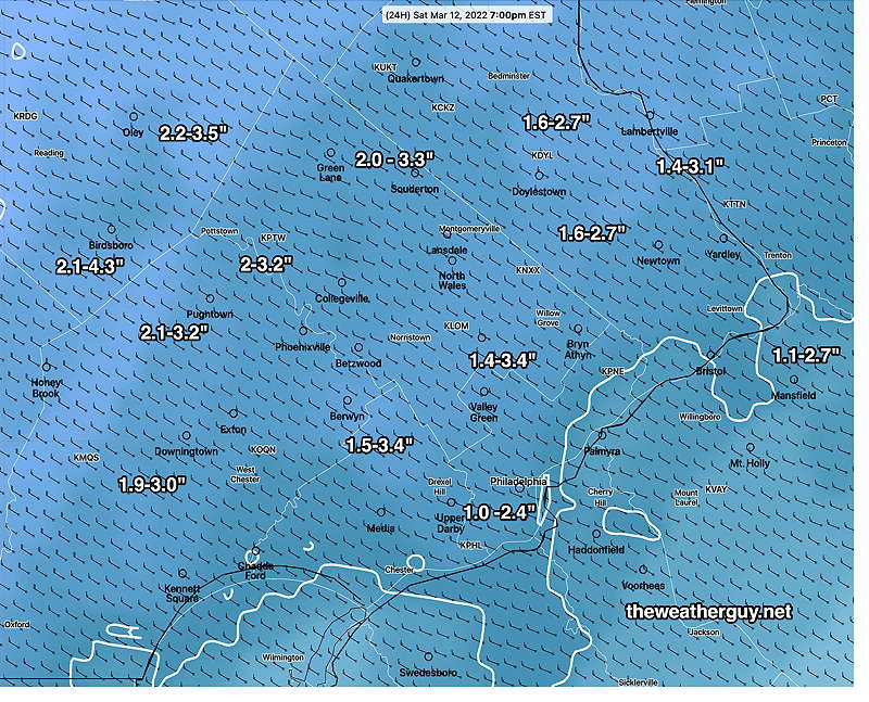
...Bucks County...
Chalfont 1.7 in 1231 PM 03/12 Trained Spotter
New Hope 1.5 in 1145 AM 03/12 Trained Spotter

...Chester County...
West Caln Twp 3.0 in 1226 PM 03/12 Trained Spotter
Malvern 2.7 in 0122 PM 03/12 Public
2 WNW Phoenixville 2.5 in 1223 PM 03/12 Public
East Coventry Twp 2.0 in 1200 PM 03/12 Trained Spotter
Phoenixville 1.5 in 0145 PM 03/12 Trained Spotter

...Delaware County...
Boothwyn 0.5 in 1200 PM 03/12 Public


...Montgomery County...
New Hanover Twp 3.5 in 1233 PM 03/12 Trained Spotter
Trooper 3.2 in 1050 AM 03/12 Public
Norristown 3.1 in 0130 PM 03/12 Trained Spotter
East Norriton 1.3 in 1215 PM 03/12 Trained Spotter

...Philadelphia County...
Phila Int Airport  Trace in 0100 PM 03/12 ASOS

Sunday Forecast