Category Archives: Philadelphia Area Weather Forecasts

WEEKEND WEATHER FORECAST

#weather #paweather #wx #pawx #philadelphia #phillywx

Sunday Forecast Update

Update Sat 06/03 @ 8:45 PM — Little change in Sunday’s forecast. High temp 74.0º with a higher than usual standard deviation of 2.8º

The blocked pattern we’re in remains little changed through the end of the week. There’s some evidence that the cool cyclonic flow we’re in will breakdown sometime next weekend and that the block may shift or lose amplitude by the middle of the month.

NAEFS upper air (jet stream level 250 mb) wind flow for Tuesday shows several impulses expected to circulate around upper low over New England. These may spawn surface low pressure with an increased chance of some light shower activity on Tuesday

There’s also some suggestion that another upper low may move in to replace this one. We’ll have to wait to see.


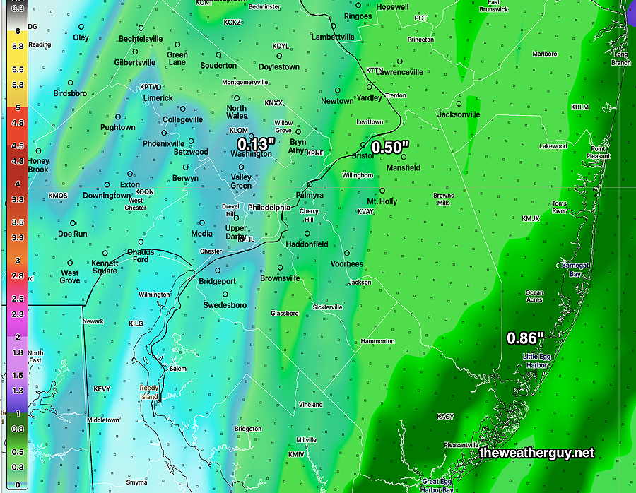
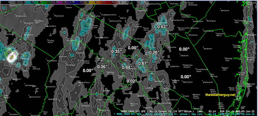
How much rain did we get?

Update Sat 06/03 @ 10:42 AM —So how much rain did we get Friday evening? Here’s the MRMS radar- rain gauge estimate —

MRMS estimate of rainfall over the Philadelphia area Friday evening. Not much in most areas with a few lucky exceptions. (Click on image for a larger view.)

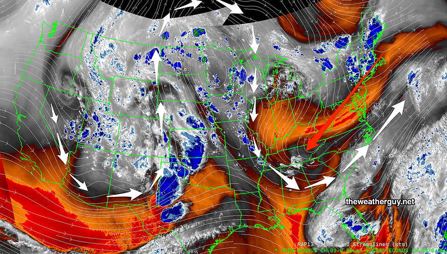
Update Sat 6/03 8:30 AM — More sun currently than forecast by most models (with the exception being the Canadian HRDPS). With most models, including the NBM, still showing the development of instability clouds, I’m going to stick with the forecast of cloudiness developing late morning into mid-afternoon, but it’s a low confidence forecast.


Previously Posted Fri 5:49 PM —

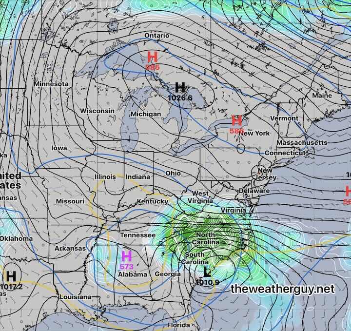
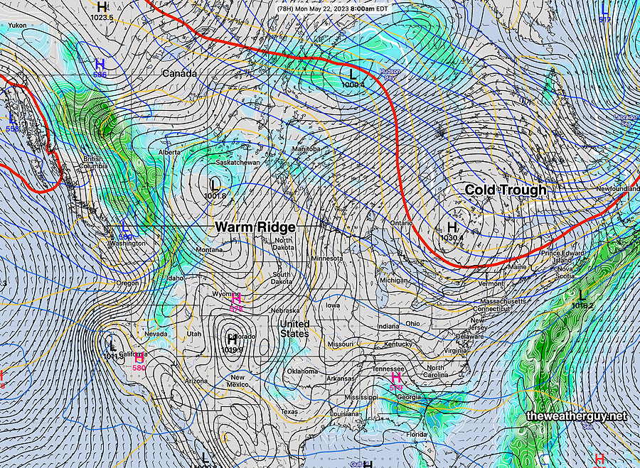
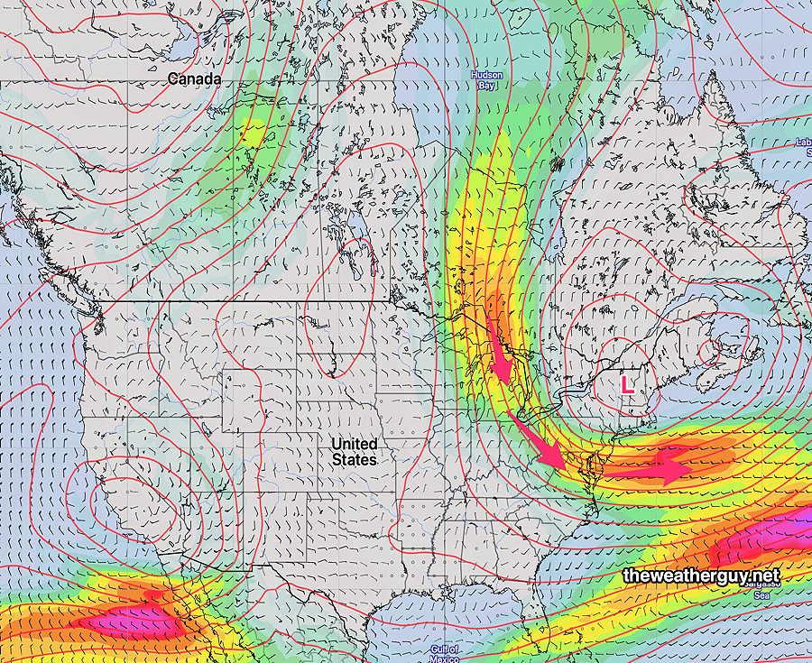
The blocking pattern will continue into this weekend as a well-entrenched Omega block (Ω) gets reinforced with a deepening cyclonic dip over our area that is pushing southwestward. A backdoor cold front is moving through this evening propelled by the upper level cyclonic dip—

Omega Block (white jet flow arrows) with sharpening upper air trough pushing southwestward (red arrow) (Click on image for a larger view.)

Saturday

An upper cyclonic flow will cause instability cloudiness. Minor chance of a sprinkle in the morning. A considerable amount of cloudiness morning into mid afternoon. More sunshine by late afternoon. Breezy and cool.

High temperature 74.1º sd 2.0º ( NBM model— location Blue Bell, PA)

Sunday

Sunny and cool. Breezy.

High temperature 75.3º sd 2.4º ( NBM model— location Blue Bell, PA)


WEEKEND WEATHER FORECAST

#weather #paweather #wx #pawx #philadelphia #phillywx

Monday Forecast Update

Update Sun 05/28 @ 6:19 PM— Some cloudiness moved in today as expected and Monday will be similar with high clouds from the city northward and some thicker mid-level cloudiness in areas south of the city.

The Jersey shore will be chilly with an easterly wind flow and significant cloudiness from Atlantic City southward. Some sprinkles possible around Cape May and Delaware.

High Temperatures Monday—

NBM High Temperatures Monday. (Click on image for larger view.)

Looking ahead, another Omega block takes hold over the coming weekend. No rain expected until June 7th!


Update Sun 05/28 @ 7:18 AM — We may see some periods of clouds from the city and southward today along with periods of sun. Northward of the city, things look good. The Jersey Shore will see cooler temps from an easterly wind and some light showers can’t be ruled out in far southern areas (Cape May) and Delaware later in the day. I’ll update later today.


Previously Posted Fri 3:11 PM —

There haven’t been any postings this past week because I’ve been away, but I’ve been keeping an eye on the models and the local weather remotely.

We remain in a very dry pattern with a stalled upper low in the southeastern US and a persistent upper ridge and surface high pressure system blocking any rain from moving into the Philadelphia area from the south. This will continue over the weekend.

The latest NAEFS model forecast for Sunday shows this setup—

NAEFS forecast for Sunday morning. (Click on image for larger view.)

This very dry pattern is a bit of a concern, with our still being in May. Our springtime weather is often much wetter. Hopefully things change; if not, I see the likelihood of parched lawns and stressed trees this summer, as we had last summer. Possibly worse.

Anyhow, it may be premature to worry about a “pattern” with just three weeks of minimal rainfall. I guess we’ll see.

The forecast for this weekend is straightforward, provided the system to our south remains to our south. More uncertainty for Monday.

Saturday

Sunny with high thin cirrus cloudiness at times as some moisture from the south tries unsuccessfully to move northward.

High temperature 76.7º sd 1.4.º ( NBM model location Blue Bell, PA)

Sunday

Sunny but a bit more cloudiness southern areas, especially late in the day. Moisture from the south still trying to move northward will cause the cloudiness towards Delaware and South Jersey.

High temperature 78.8º sd 1.8º ( NBM model location Blue Bell, PA)

Monday – Memorial Day

Sticking with the NBM model, some cloudiness just north of the city, becoming sunny in the afternoon. Cloudy in areas south of the city, especially South Jersey and Delaware. Some very light sprinkles are possible in the same areas.

NBM clouds forecast 1PM Monday. Clouds recede partially southward during the afternoon. ( Click on image for larger view.)

High temperature 81.5º sd 2.1º ( NBM model location Blue Bell, PA)


WEEKEND WEATHER FORECAST

#weather #paweather #wx #pawx #philadelphia #phillywx

Update Fri 5/19 4:05 PM — This afternoon’s models suggest a heavier band of rain may develop directly over Philadelphia. That would be a significant change in the forecast of the past several days.


Previously Posted Fri 9:45 AM —


A coastal system will brush the Philadelphia area with light showers as it moves northeastward early Saturday morning.

A cold front approaches from the west during the day Saturday and moves through early Saturday evening with showers and possibly a few thundershowers. Most of the energy and rain will move up to our west missing us.

The models are in general agreement that the immediate PHL area and some areas to our immediate west likely will miss out in some much-needed rain—

HREF model forecast for total precipitation for Saturday. (Click on image for a larger view.)

Following the cold front, we’ll re-emerge into the same general pattern of a cooler and dry weather pattern—

NAEFS forecast for Monday shows pretty much the same pattern we’ve been in: a cool trough pattern over the northeastern US and a warm ridge over the west.

Saturday

Clouds and showers in the morning, mainly from the city and east into NJ. Becoming sunny thought high cirrus clouds for much of the day. Clouds roll in later afternoon with some light showers in the evening. Many places from the city and immediately westward may not see any showers.

High temperature74.4º sd 2.9º ( NBM model location Blue Bell, PA)

Sunday

Sunny. Breezy

High temperature 77.7º sd 2.0º ( NBM model location Blue Bell, PA