Category Archives: Philadelphia Area Weather Forecasts

WEEKEND WEATHER FORECAST

#weather #paweather #wx #pawx #philadelphia #phillywx

Sunday Forecast Update
Sun 04:27 PM Forecast Review — The clouds did move in about 3 PM, as forecast last night. One of these days, I’ll learn that the latest model isn’t always the best one and I’ll leave “well-enough alone”.

Update Sun 06/18 @ 9:42 AM — Last night’s models have sunny skies for today, so I’m going to drop the cloud forecast for the 3-6 PM time frame.

There is an upper air disturbance just northwest of Pennsylvania that doesn’t appear to be captured by last night’s models—

Sunday Morning Water Vapor Satellite image showing upper air disturbance northwest of Erie PA. It appears this will move north of Philadelphia this evening with just some clouds moving in about 6-7 PM. (Click on image for a larger view.)

Some cloudiness with this disturbance is expected this evening after 6 PM, mostly north of the city.


Sunday Forecast Update

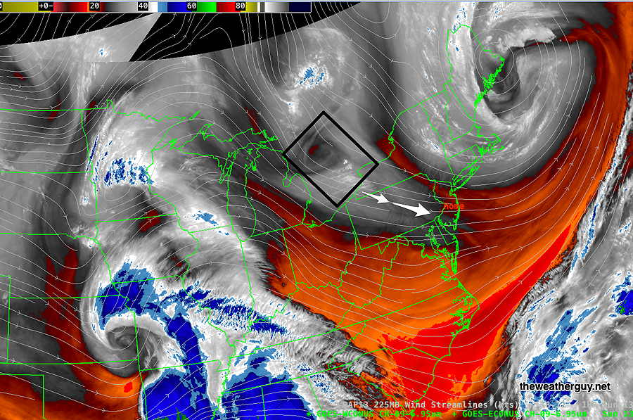
Update Sat 6/17 10:36 PM — Tonight’s high resolution models show some similarity to today’s which correctly predicted the periods of cloudiness and the few pop up showers we had. (One missing ingredient tomorrow is a strong jet streak.)

So despite the model cloud algorithms again have little to no clouds for us on Sunday, I’m thinking that an increase in cloudiness with some isolated showers is a possibility, especially areas north of Philadelphia. Most likely time frame is 3-6 PM. Not a high confidence forecast with this change.


Update Sat 6/17 10:56 AM — Mobile quick update. This morning’s high resolution models show more clouds and pop up showers today than previously forecast.


Update Sat 06/17 @ 9:27 AM — There’s a bit more hazy/sunshine cloudiness than forecast by the models right now. A new download of the HRRR shows some potential hazy sunshine/cloudiness through the day. Not captured by the models’ built-in cloud algorithms—

Todays latest HrRR shows hazy sunshine though some potential cloudiness on Saturday. (Click on image for a larger view.)

Here’s the same with superimposed vertical motion—

12z HRRR relative humidity fields with vertical motion (red/yellow/violet areas) (Click on image for a larger view.)

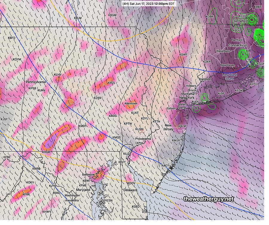
Ordinarily, the built-in cloud algorithms for the HRRR and RAP tend to overstate cloudiness. Interestingly, when there’s strong cyclonic upper flow, they tend to understate it. The above shows relative humidity fields at different levels of the atmosphere above 50-60%. Combined with areas of vertical motion, we get some cloudiness and maybe some sprinkles.


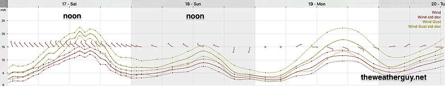
Update Sat 6/17 8:42 AM — Looking at last night’s models, I’m returning to a modified original forecast for Saturday: Some instability cloudiness possible, but mostly sunny. An isolated sprinkle possible, mainly north of our area, remains a possibility. Becoming WINDY around noontime.


Update Fri 6/16 10:52 PM — Tonight’s models show no clouds or showers on Saturday. Sunny, but windy.


Previously Posted Fri 5:14 PM —

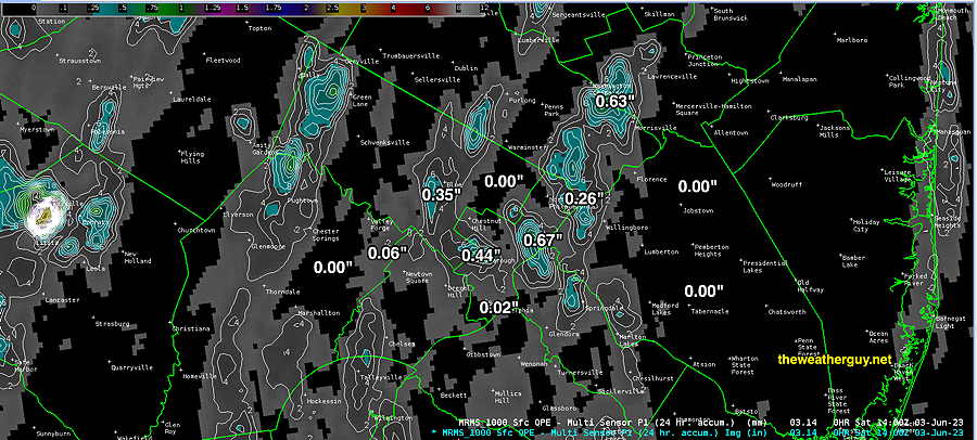
Rainfall totals for Friday were posted here.

Some showers now in central PA may make it into the western suburbs later this evening, but are forecast to dissipate before reaching the city.

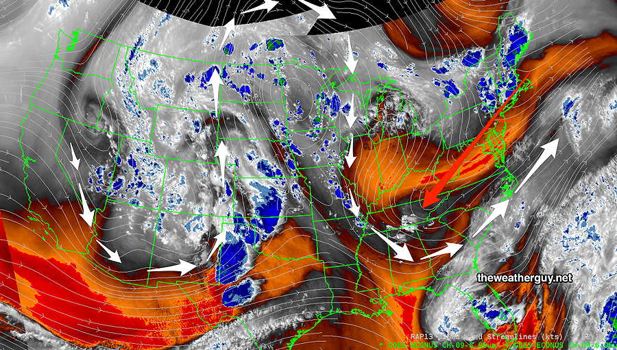
High pressure builds in for the weekend, but the upper air cyclonic flow will be with us on Saturday and significantly less on Sunday. (The re-established Omega block across the continent will keep us in some degree of upper air cyclonic flow until Wednesday or Thursday.)

Saturday

The upper air cyclonic flow keep things somewhat cooler than an average June day. Some instability cloudiness possible, but mostly sunny. A widely scattered sprinkle after 4 PM, mainly far north of our area, remains a possibility. Few areas will see them.

It it will be breezy to almost WINDY.

NBM wind meteogram (Click on image for a larger view.)

High temperature 79.6º sd 1.7º ( NBM model— location Blue Bell, PA)

Sunday

High pressure at the surface. Mostly sunny

High temperature 82.6º sd 0.7º ( NBM model— location Blue Bell, PA)


WEEKEND WEATHER FORECAST

#weather #paweather #wx #pawx #philadelphia #phillywx

Sunday Forecast Update — Monday Outlook

Update Sun 06/11 @ 9:01 AM — Today, we’ll finally see some summer-like weather. High temperatures 89º (Blue Bell) to 91º (Philadelphia). Some areas will experience some cloudiness at times during the afternoon today, but “partly to mostly sunny” is the standard terminology.

Dew points, according the the NBM, will be in the upper 50s instead of the upper 60s (as forecast yesterday), so it won’t be as humid as previously predicted.

Monday looks to be “interesting”, as a cold front moves through with much needed rain. Things are looking better for a good soaking in many (but not all) areas. The Canadian models are treating this as a warm front in the morning, followed by a cold front in the evening.

As a result, the RGEM and HRDPS have been predicting some shower activity as early as the late morning, followed by thunder showers from the afternoon through 9 PM.

Our NOAA models are underplaying the warm front and emphasizing the strong cold front, with showers and thunderstorms, from mid afternoon into the evening.

06z HRRR total accumulated rain forecast by Tuesday morning. Every model will show a very different range and areal coverage of precip, so don’t take the locations of the higher totals literally. (Click on image for a larger view.)

Precipitable water (PWAT) is in the 1.7″ to 2″ range, so some areas may get rainfall in that upper range. Generally 0.6″ to 2+ inches of rain is expected.

No tornadic activity is expected, and while strong storms are possible, many of the severity parameters are in the moderate range.

(I’m sure there will be official “severe thunderstorm warnings”, since there are liability issues in not issuing these. If you or your house gets hit by lightning, I guess it’s ‘severe’. )

Severity parameter forecasts have a strange way of dramatically increasing the day of the event, so I’ll be keeping an eye on this.


Saturday-Sunday Forecast Update

Update Sat 06/10 @ 9:28 AM — There’s some uncertainty with the amount of cloud cover for Sunday afternoon. Last night’s models showed only high level cirrus cloudiness, but several models are suggesting some periods of some mid and low level clouds (with sunny breaks) by mid afternoon.

The Canadian HRDPS is also showing the possibility of widely scattered showers/thundershowers far north of the city by 3-4 PM

Today’s 06z HRDPS forecast rain rate for 3-4 PM Sunday. (Black-grey = clouds). (Click on image for a larger view.)


Previously Posted Fri 5:30 PM —

Following the passage of an upper air trough through our area Friday evening, high pressure in the western Atlantic will circulate warmer air into our area over the weekend—

Today’s 12z ECMWF shows the departing upper low (blue L arrow) and the Bermuda High (H) in the Atlantic and its southwesterly flow bringing in warmer (and cleaner) air for the weekend. Out in the Midwest is our next system to affect us on Monday. (Click on image for larger view.)

As mentioned last week in several posts, there appears to be a breakdown happening in the long-standing Omega block (Ω) that has been responsible for our cooler and dry weather for the past 5 weeks.

The new pattern, expected by the end next week, will likely be much warmer for us, but it’s unclear that it will become much wetter as well.

Indeed, Monday’s cold front that should bring some significant showers and thunderstorms to areas west of us, but may not bring all that much rain to Philadelphia and New Jersey. We’ll have to see.

Saturday

Mostly sunny.

High temperature 80.4 sd 2.0º ( NBM model— location Blue Bell, PA)

Sunday

Mostly sunny in the morning, gradually increasing cloudiness in the afternoon as some moisture from the system in the Midwest moves in aloft.

High temperature 88.0º sd 1.5º ( NBM model— location Blue Bell, PA)

WEEKEND WEATHER FORECAST

#weather #paweather #wx #pawx #philadelphia #phillywx

Sunday Forecast Update

Update Sat 06/03 @ 8:45 PM — Little change in Sunday’s forecast. High temp 74.0º with a higher than usual standard deviation of 2.8º

The blocked pattern we’re in remains little changed through the end of the week. There’s some evidence that the cool cyclonic flow we’re in will breakdown sometime next weekend and that the block may shift or lose amplitude by the middle of the month.

NAEFS upper air (jet stream level 250 mb) wind flow for Tuesday shows several impulses expected to circulate around upper low over New England. These may spawn surface low pressure with an increased chance of some light shower activity on Tuesday

There’s also some suggestion that another upper low may move in to replace this one. We’ll have to wait to see.


How much rain did we get?

Update Sat 06/03 @ 10:42 AM —So how much rain did we get Friday evening? Here’s the MRMS radar- rain gauge estimate —

MRMS estimate of rainfall over the Philadelphia area Friday evening. Not much in most areas with a few lucky exceptions. (Click on image for a larger view.)

Update Sat 6/03 8:30 AM — More sun currently than forecast by most models (with the exception being the Canadian HRDPS). With most models, including the NBM, still showing the development of instability clouds, I’m going to stick with the forecast of cloudiness developing late morning into mid-afternoon, but it’s a low confidence forecast.


Previously Posted Fri 5:49 PM —

The blocking pattern will continue into this weekend as a well-entrenched Omega block (Ω) gets reinforced with a deepening cyclonic dip over our area that is pushing southwestward. A backdoor cold front is moving through this evening propelled by the upper level cyclonic dip—

Omega Block (white jet flow arrows) with sharpening upper air trough pushing southwestward (red arrow) (Click on image for a larger view.)

Saturday

An upper cyclonic flow will cause instability cloudiness. Minor chance of a sprinkle in the morning. A considerable amount of cloudiness morning into mid afternoon. More sunshine by late afternoon. Breezy and cool.

High temperature 74.1º sd 2.0º ( NBM model— location Blue Bell, PA)

Sunday

Sunny and cool. Breezy.

High temperature 75.3º sd 2.4º ( NBM model— location Blue Bell, PA)