
#Philadelphia #weather #PAwx
Friday Weather Update
But today, I put in an unusually large effort to forecast the storms, but to no avail. The models were all pretty much wrong in one way or another. I reluctantly have reached and agree with the conclusion, “All models are wrong, but some are useful.” — George EP Box , noted British statistician.
Going forward, I’m going change my approach to thunderstorm forecasting.
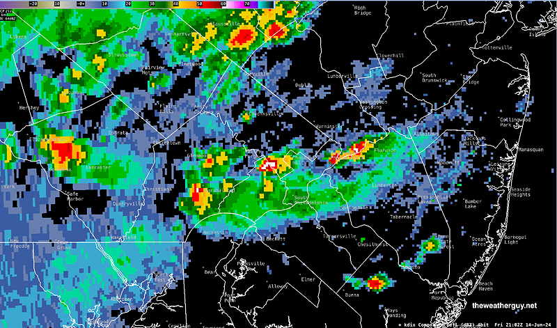
Posted Friday 06/14/24 @ 5:16 PM — With all this prognosticating today, some heavy cells have popped up early and not where forecast!
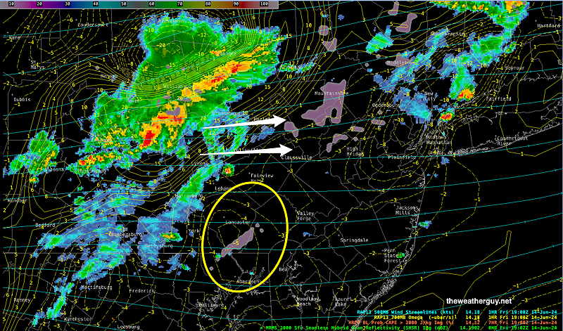
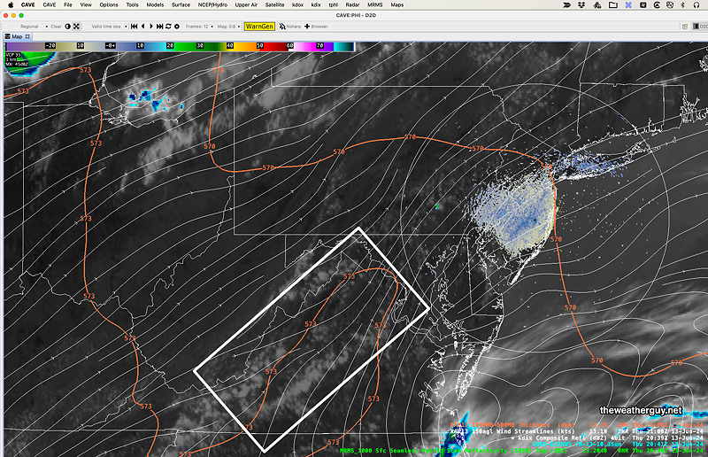
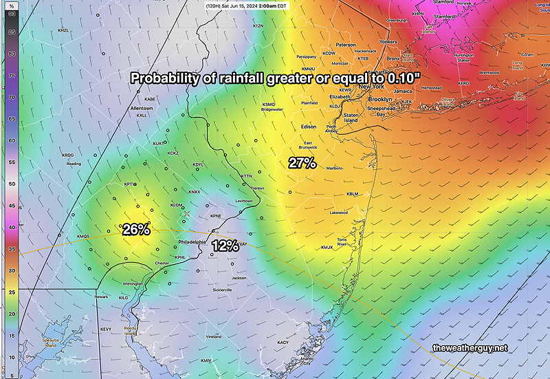
Posted Friday 06/14/24 @ 3:18 PM — The current radar (MRMS) and RAP model depicts the current conditions that support the forecast for the heaviest thunderstorms to move off to our north. Check out the graphic caption for more info—
Based on this, the forecast posted earlier this morning (below) appears to be supported. Of course when it comes to weather —a dynamic and chaotic process — things could change.
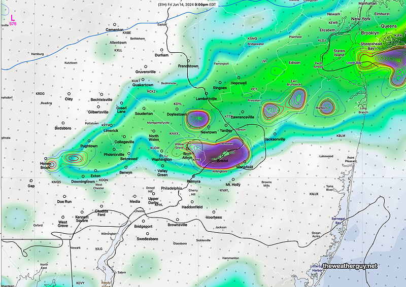
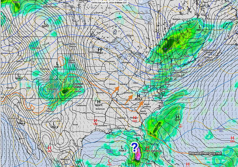
Posted Friday 06/14/24 @ 12:30 PM — The latest Canadian HRDPS model captures the forecast I’ve been trying to convey with my earlier update. It shows heavier storms to our north and west, but large areas of the immediate Philadelphia area receive no rain!
As many of my regular readers know, the model exact placement of forecast heavy rain is something that very often comes up short. But this trend where the heavier activity skips over Philadelphia and re-forms in NJ is something different models are all suggesting.
Despite my forecast of low severity potential here in Philadelphia, always follow the the official NWS forecast warnings in these situations.
Friday’s ‘Storms’
Posted Friday 06/14/24 @ 8:18 AM — Last night’s models continue with the forecast of a highly broken line (maybe batch) of showers and storms affecting our area late afternoon into evening. The heaviest activity will remain north of us and some areas in the immediate Philadelphia area may see little in the way of rain or storms. A severe weather event here is low probability. A 3 hour time lapse of the 06z HRRR captures this—
A second group of showers and possibly thundershowers moves through about 11 PM to midnight. We could use the rain, but this front, for reasons described in previous updates, likely won’t provide it. We’ll be entering a dry and hot stretch of weather starting late Monday.
I’ll update if this morning’s models move in a different direction.
Friday Weather Update
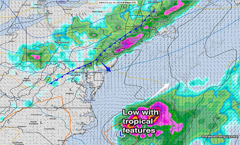
Posted Thursday 06/13/24 @ 5:30 PM —Several models show a disturbance moving in from the southwest this evening, possibly causing some showers and thunderstorms in Chester county, perhaps into the city. On satellite imagery, I see the disturbance but not any showers at this time. A low confidence event —
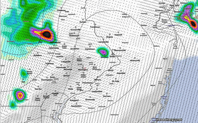
As for Friday, showers and thunderstorms move in ahead of the cold front as early as 4-5 PM far northwest suburbs and into the early evening (6-11 PM) in the city. As discussed in this morning’s update, the line of showers/thunderstorms will be broken and doesn’t appear to be overly severe, although a few spots show potential. —
Heaviest activity in central and northern NJ and in into Delaware and Maryland. The showers may linger and blossom a bit towards midnight before moving off for a nice weekend.
I’ll update Friday.
Thursday Friday Weather Update
Posted Thursday 06/13/24 @ 8:15 AM — Today, Thursday, will feel more like June here in Philadelphia, with temperatures approaching 90º in the mid to late afternoon and dew points moving from the comfortable mid 50s to the low 60s this afternoon.
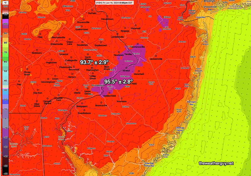
Friday will see hot weather with highs 90-93º and dew points moving into the more uncomfortable low to mid 60s.
Friday‘s cold frontal passage timing continues to change back and forth, but has reverted back to the late afternoon/early evening, more specifically 6 PM to 9 PM. A line of showers and thunderstorms will move towards us, but it appears that this line will become broken as a result of these storms not having upper air support (no adjacent jet streaks) and another system, now affecting Florida, will be out int he Atlantic to our east, robbing the front of some upward vertical motion. Some areas may see a heavy thunderstorm, but many may not.
The severe weather parameters in the CAM models (Convection-Allowing Models such as the HRRR) often don’t show possibility of severe weather until 24 to 12 hours before the event, so things may change with tomorrow’s forecast. Right now, things don’t look too severe.
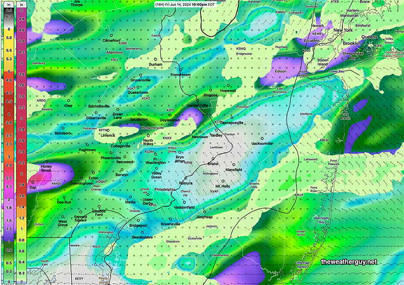
Total rainfall will only be in the 1/2″ range, with some locally higher amounts.
This upcoming weekend looks very very nice with cooler temperatures and low humidity. Heat returns after Monday.
Additional Forecast Changes Wednesday thru Friday
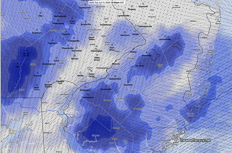
Posted Tuesday 06/11/24 @ 4:20 PM — We had significant cloudiness today at times, as forecast in my update yesterday. However the shower activity has been much less than forecast, continuing a recent trend where the model forecast total precip is over-stated.
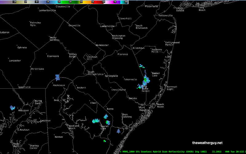
Here’s the current radar showing a paucity of rain. —
The latest models show more forecast changes through Friday.
First, tomorrow, Wednesday, will be cooler than previously forecast, likely staying in the low 80s. Some clouds at times, but there will be significantly more sunshine than today and more sun than had been forecast yesterday.
Thursday warms up, but not as hot as previously forecast, likely staying just under 90º. A few pop-up widely scatted thundershowers possible mid to late afternoon. Most areas dry.
The big forecast change is for Friday, where a cold front will be moving through during the mid to late afternoon into the evening. (Previously, the front was expected late evening into the night.) Thunderstorms, are possible late afternoons and early evening. Rainfall forecast is on the light side.
Highs will be in the near 90-92º, but there’s great uncertainty in that temperature due to uncertainty with clouds and the timing of the front. We may not get that hot. The standard deviation (uncertainty) is as high as ± 5º with some ensemble models and it’s likely trending towards the cooler range.
Forecast Change for Tuesday, Wednesday
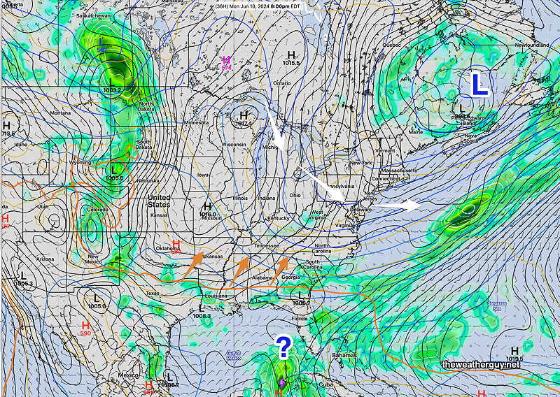
Posted Monday 06/10/24 @ 7:02 PM —This afternoon’s 18z models have added showers and thundershowers late afternoon Tuesday from the city eastward into NJ as well.
Posted Monday 06/10/24 @ 4:54 PM —Today’s models are now showing several upper air disturbances moving through our area early Tuesday morning and again late Wednesday morning through Wednesday afternoon. These disturbances will allow a warm front to move through about the same time frame.
Sunshine, but more cloudiness than previously forecast for both Tuesday and Wednesday, along with light widely-scattered showers, near Philadelphia before daybreak Tuesday morning and mostly in NJ Wednesday afternoon.
A rumble of thunder also possible, especially near the Jersey Shore, according to the ECMWF and Canadian models on Wednesday afternoon. Any showers will be light. Many/most areas will not see any rain, but considerable cloudiness at times.
End of Week Heat
Posted Monday 06/10/24 @ 9:00 AM — Following spectacular days Monday and Tuesday, seasonably warm temperatures return Wednesday and hot days are expected Thursday and especially Friday.
Friday is currently forecast to be especially hot—
Unfortunately, I don’t see much rain over the next week, with the only chance Friday night as a cold front moves through. That amount doesn’t currently look to be very high—
Previously Posted Sun 4:50 PM —Cooler than average and beautiful weather expected here through at least Thursday. The NAEFS forecast map for Monday captures the main features—
By the end of the week, hotter air begins to approach our area with temperatures possibly near or above 90º by Thursday or Friday.
Another cold front moves through later Friday into Saturday with a brief cool down for next weekend. Hot weather expected the following week.
Except for the cold front passage next Friday, things will be dry. It will take a tropical system to give us substantial rain with this pattern.