WEEKEND WEATHER FORECAST

Update Sat @ 5:07 PM Sunday’s forecast (below) remains on track with clearing from west to east between 10 AM and about noon. Colder, more seasonable temperatures on the way.

Next week has a flat jet flow (shown below) with little chance of any snow here in the Philadelphia area for Christmas.

No major weather events currently predicted for us, although there are some significant differences emerging in the long range ensemble models that may throw some spice into an otherwise straightforward outlook.


Update Fri @ 10:50 PM — Tonight’s models have the rain lingering until late morning. Then dark low clouds, but there’s the possibility of drizzle, fog and mist continuing. A memorably gloomy day with the low sun angle behind a thick, low cloud deck.

The sun returns by late morning Sunday.


Update Fri @ 5:55 PM — This afternoon’s models show little change in the forecast below. Saturday forecast changes are highlighted below.


Previously Posted Fri 10:20 AM —

This early edition forecast will be updated Friday evening.

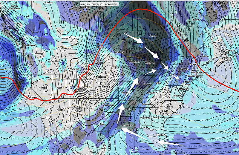
A blocked pattern with a split jet stream has affected our area and has given us the mild weather this past week, as described in the graphic caption below—

Jet Stream forecast for Sunday 10 PM. (300 mb wind speed). Blocked pattern due to major ‘kink’ (1) in the jet flow over Pacific has caused the upper scale ridge (2) to be with us for most of this past week. This ridge (2) will finally move offshore by Sunday evening, allowing more seasonably cold air to move in. However, the jet flow will be split between two streams, causing long range forecast uncertainty next week. A flat component to the jet (3) will move in for much of next week, but the southern jet may create some interesting weather.

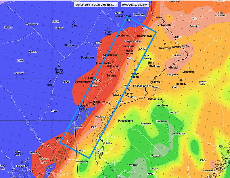
For this weekend, a cold front will move through as the above mentioned upper ridge (2) moves east into the Atlantic.

Saturday

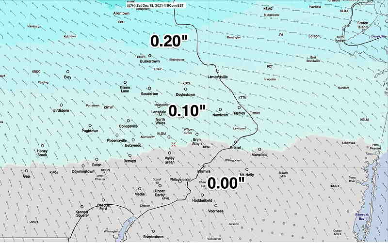
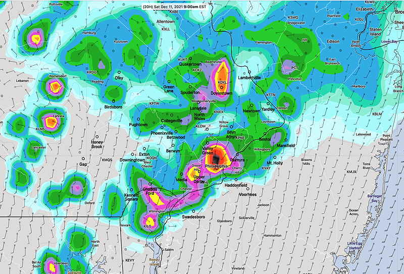
A departing high pressure system will bring an easterly damp, colder flow ahead of an approaching cold front. Most of the showers will move through early Saturday morning and be north of us by 9-10 AM.

The remainder of the day, dark low-level cloudiness and damp with a chilly easterly wind. Some fog and haze also expected. Showers return during the evening and after midnight ahead of the actual cold front. High temp 47.4º ± 3.0º NBM model Blue Bell.

Sunday

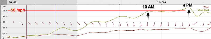
The front slowly moves through after midnight Saturday and Sunday will start cloudy, but clouds should break for sunshine about 10-11 AM. Somewhat windy. High temp 42.7º ± 2.1º NBM model, Blue Bell.

Winds
NBM Wind forecast Blue Bell PA

THIS WEEK’S WEATHER

Update Thu @ 9:14 PM — This afternoon’s models continue to forecast rain Saturday morning until about 10 AM, then just cloudy. Showers return by evening. Morning clouds on Sunday, then sunny


Update Thu @ 10:18 AM — Well, this morning’s HIRESW models have some rain in our area until about 10 AM Saturday, then just cloudy. So the NBM -based forecast update post below may be too optimistic with rain staying north.


Update Thu @ 8:45 AM — The models continue with very light rain/sprinkles north of the city. It will be quite cloudy, but the NBM has almost no rain in the Philadelphia area and south before 4 PM Saturday—

NBM 12z Model for Saturday at 4 PM. Almost no rain in Philadelphia during the daytime hours. (Click on image for a larger view.)

Model Blend (NBM) forecast 4 PM Saturday, showing little to no rain in the immediate PHL area through 4 PM. Rain overspreads the area Saturday night. High temperatures 51º ± 3º


Update Wed @ 9:21 PM — Not much change in the forecast. Warm weather (for December) expected on Thursday and Friday.

Low pressure moves in Friday night and Saturday with clouds and showers. The heavier rain remains far north of our area. The only change is that the system is moving a bit slower than had been previously forecast with my prior update.

GFS forecast for 5 PM Saturday (Click on image for a larger view.)

Sunday looks to become mostly sunny, but colder.

Next week looks colder still.


Update Tue @ 9:42 AM — The milder weather is on its way through the end of the week. The increase clouds mentioned below are also on their way.

The models are in good agreement about low pressure developing in the Mississippi Valley and moving over our general area on Saturday with rain for much of the day. High pressure builds in on Sunday with seasonably colder weather.

GFS surface forecast for Saturday noon. Low pressure will have moved into western Pennsylvania with rain in our area. Low pressure continues to develop off the coastline and moves into New England. (Click on image for a larger view.)

Previously Posted Sun 6:02 PM —

Following a very mild Saturday and a more seasonably cold Sunday, this week’s weather will be influenced by an upper air ridge. This upper ridge will bring above seasonal average temperatures to our area through Friday.

A secondary effect of this upper air ridge will be a flow of increasing moisture and development of significant cloudiness by Wednesday—

GEFS Wednesday forecasts showing increased moisture (blue-grey shading) and the strong upper ridge.

The entire ridge will shift east and flatten for the weekend. An increased chance of rain is likely by Friday or Saturday. Following the warmup this week, no extreme cold outbreaks are seen for us.

Right now, the long range outlook is for no snow storms through Christmas.

WEEKEND WEATHER FORECAST

Update Sat @ 6:05 PM — Some bright spots occurred today, but none of the sunshine I had though might been possible.

The front expected to move through our region a bit later, between 8-10 PM tonight with gusty winds and briefly heavy rain.

An overlap of high shear/high helicity is forecast by the HRRR in the blue boxed area around 9 PM. Fast moving, strong thunderstorms with high winds possible—

HRRR forecast 9 PM High shear/ high helicity. This area will move east/northeast. (Click on image for a larger view.)

Sunday’s forecast looks good.


Update Sat @ 9:43 AM — Most models this morning maintain the low cloud cover. I still think there’s a chance of sun breaking through in the early afternoon.

This morning’s models have some areas of high shear and high helicity about 6 PM near Philadelphia. Some severe storms could develop at that time—

HRRR forecast 6 PM Saturday. Blue boxed areas are areas forecast to have high helicity (contours) and high shear (shading). Severe thunderstorms area possible. (Click on image for a larger view.)

Wind gust forecasts have been reduced to about 40-45 mph instead of the 50 mph previously forecast.


Update Sat @ 8:22 AM — The new Canadian GEM model now predicts significant sunshine breaking through around 2 PM in areas from Norristown eastward. The cold front moves through 6-9 PM with showers and maybe some thunder. GUSTY WINDS this afternoon and with the frontal passage.


Update Fri @ 9:33 PM — Tonight’s early models have some changes: the heavy morning showers on Saturday, depicted in this afternoon’s HRRR rain graphic (below), now are forecast to move more north and west of the city. So it doesn’t look like the morning showers Saturday will be that heavy around the immediate PHL area.

Another change: the latest HIRESW-FV3 does have some bright spots and breaks of sunshine develop around noon and early afternoon. (mentioned below). If that occurs, expect the windy conditions to be somewhat more pronounced due to ” vertical mixing” of sun-warmed air with strong upper winds.


Initial Post Discussion—[post_published]

A warm front will move through the area Friday night into Saturday morning. Very mild air will move in behind the warm front. A very strong cold front moves through Saturday evening.

Saturday

Saturday’s forecast has changed somewhat since yesterday, especially with likely showers during the morning hours.

The warm front moves to our north about 6-8 AM. The latest HRRR shows some heavy shower activity about 6-9 AM in Philadelphia—

HRRR 1 hour precipitation rate 9 AM Saturday. Heavy rainfall forecast in some areas. (Click on image for a larger view.)

Most of the showers move to our northeast, but the HRRR and NAM-NEST are showing lingering widely scattered light showers/drizzle until late morning. (Earlier forecasts had the showers ending much earlier, then cloudy and windy.)

After the morning rain, most models keep us with low level clouds and very windy. I’ve seen situations where models incorrectly show little clearing following a warm front passage. So I while I would expect cloudy conditions, don’t be surprised if some sun breaks through during the afternoon.

It should be dry between noon and 6 PM.

High temperature 67.7º ± 2.3º (NBM Blue Bell)

It will become very WINDY, with most models having wind gusts of 40-50 mph, although the model blend (NBM) wind gusts are in the 35-40 mph range.

HRRR wind meteogram Blue Bell. High gusty winds forecast. (Click on image for a larger view.)

The front moves through between 7 PM and 9 PM Saturday evening with a quick burst of showers and high wind gusts.

Sunday

High pressure builds in for Sunday. Becoming mostly sunny and seasonably cold. Winds diminish. Breezy. High temperature 47.6º ± 1.1º (NBM Blue Bell)

Looking ahead… next week shows a large upper air ridge developing. Very mild weather likely.