WEEKEND WEATHER FORECAST PREVIEW

Update Thurs 8 PM highlighted below
Update Fri 11:30 AM highlighted below

High pressure that brought in the chilly weather for Thursday will be well off the coast by Saturday.

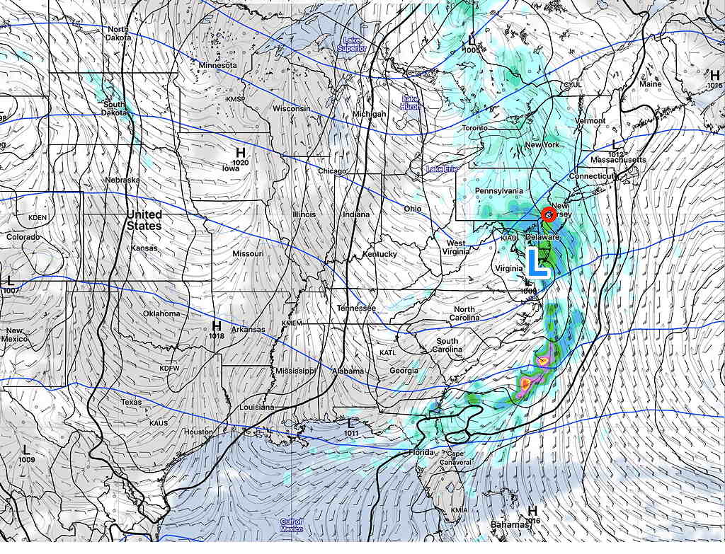
Low pressure advancing towards us will develop as it moves in our direction. Depending upon the model, it will be right over us or just to our south Saturday night.

GFS Model Surface Forecast Sunday at 2 AM  (Click on image for a larger view.)

Saturday

A return flow of moisture ahead of this low pressure system will bring considerable cloudiness for Saturday, but no rain expected during the daytime.

Update: Saturday will be sunny in the morning, then thickening high clouds. Mostly cloudy by about 3-4 PM Saturday.

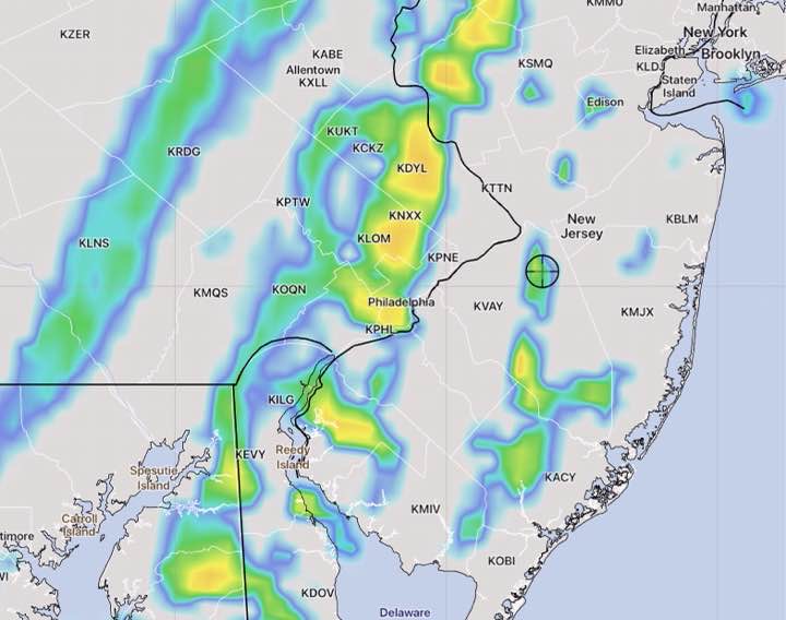
Rain should develop Saturday evening. Rain starts about 6-8 PM. Fairly heavy rain at night. Rain starts about 9-11 PM. Total amounts have decreased to about 0.6-0.9 inches of rain.

There are some differences between the Canadian and US models, but the US models have been consistent that we get about 0.75 + inches of rain Saturday night. (The Canadian GDPS has less development and much less rain.) High about 68º NBM Blue Bell with low spread (uncertainty) of 0.8º

Sunday

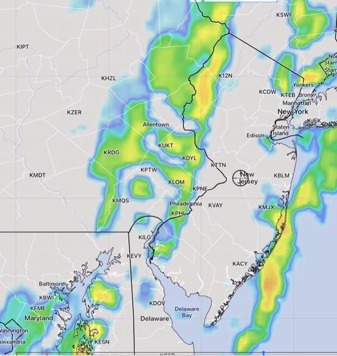
The big question is how much development, how quickly the storm leaves and how much of an increase in its size due to intensification on Sunday. The models have varied. The NAM has some clearing Sunday morning. The GFS, Canadian and Model Blend (NBM) have lingering showers and clouds into late morning or early afternoon.

Update: Most models are showing the rain ending in the early to mid morning Sunday with gradual clearing.

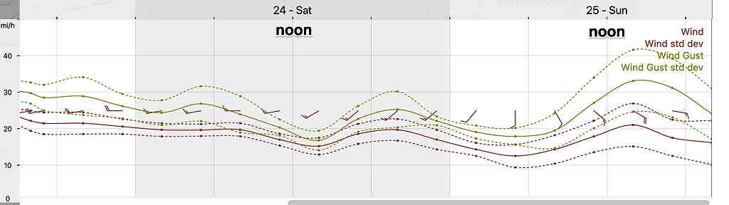
High about 65º NBM Blue Bell with moderate uncertainty of 2.8º Very Windy.

Wind Forecast

Windy on Saturday, Very Windy on Sunday  (Click on image for a larger view.)

THUNDERSTORMS WEDNESDAY?

Thu 10:02 AM Forecast Review — The HREF and HIRESW did well with forecasting yesterday’s frontal passage.

Updated Wed 8 AM highlighted.

A cold front will move through Wednesday between 12:30 and 4 PM. Thunderstorms were originally forecast to develop with this front although the forecast has been for less than 1/4 of an inch of rain to fall.

Fast moving system. Moving through Philadelphia closer to 12:30 to 2 PM (per HIRESW-FV3 shown in 2nd graphic below.) Cloudiness ahead will limit available energy. Strong wind gusts with system. Total rain about 0.25 inches water.

Tonight’s models are just becoming available and the RAP, HRRR and NAM are very unimpressive with the line of storms.

Also just available is the high resolution HIRESW-ARW.  It maintains a line of storms about 2 PM with somewhat higher rainfall and higher winds.

HIRESW-ARW MEM2 Model simulated Radar forecast 2 PM Wednesday 

The HIRESW-ARW did well last year with thunderstorm forecasts and we’ll see how it does tomorrow.

Another model of interest is the new, soon to be released HIRESW–FV3.  It has the showers and thunderstorms coming through an hour earlier, at 1 PM—


SOME BIRDS OF 2020-21

It’s been awhile since I posted some bird pictures. All of my bird pictures can be found in this site’s “Birds and Wildlife” category.

Usually I devote a single post to a single bird, but here’s a brief medley of some birds I captured on camera during late 2020 or early 2021 All, except the Pileated Woodpecker, were on our bird feeders or in our backyard.

Northern Flicker  (Click on image for a larger view.)


Northern Flicker (Click on image for a larger view.)


Yellow-bellied Sapsucker (Click on image for a larger view.)


Yellow-bellied Sapsucker  (Click on image for a larger view.)


Red-Tailed Hawk in the backyard Click on image for a larger view.)


A common, simple but pretty Nuthatch (Click on image for a larger view.)


Pileated Woodpecker seen in Fort Washington State Park in October 2020.
Captured (unfortunately) only on an iPhone at a distance.

At the present time, we have a pair of Red-bellied Woodpeckers that have created another home in an old tree in our backyard. I hope to have some decent videos of them soon.