WEATHER OUTLOOK

[su_note note_color=”#d9f2da”]Updated Fri 7AM:  The GFS seems to be the most consistent model with the others trending towards its solution— A front moves through Tuesday, with some light rain, as the low pressure system develops to our north and east. The cold air arrives too late for much snow in our area.

Specifically, the cold air doesn’t come in until the precipitation is ending late afternoon or early evening on Tuesday. At best, a coating to under an inch of snow is possible Tuesday by 8 PM  with an emphasis on the lower range.

Capturing the trend is the National Blend of Models (NBM) which has been slowly reducing its snow forecast for our area.  Here’s the current NBM snow forecast for Tuesday 8 PM:

NBM (new pre-release NBM version 3.2) Snow total forecast Tuesday 8 PM

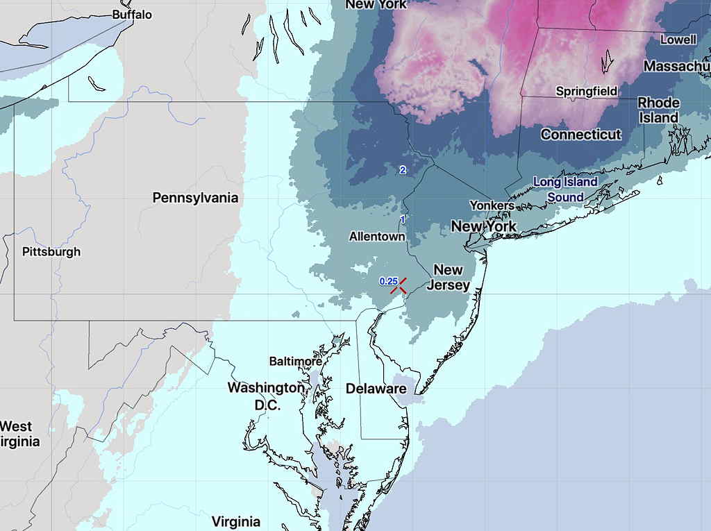
It’s likely the NBM forecast is over-done, even with its low snow totals of a coating of snow.

[/su_note]

…from yesterday (Thurs)—

[su_note note_color=”#d9f2da”]Updated Thurs 8 AM:  There’s still much uncertainty with a potential snowfall early Tuesday morning.  The Canadian CMC GDPS (Global Deterministic Prediction System) has sleet changing to snow here, while the GFS jumps the energy off the coast, mostly missing us.  Here’s the current Canadian model, showing the rain/snow line in red, moving over our area, changing sleet/rain to snow. Precip starts before daybreak and continues through Tuesday.  The current GFS forecast is very different with light showers, flurries.

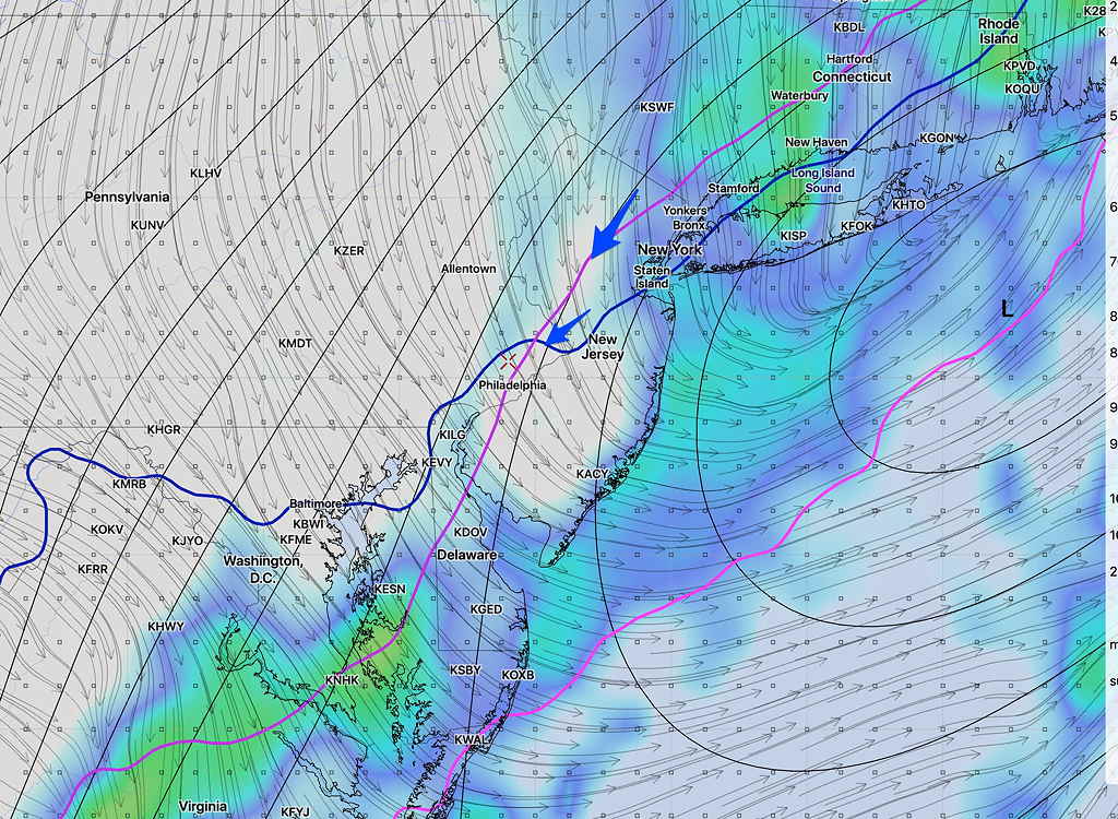
Here’s the current GFS forecast for 8AM Tuesday, showing the precipitation has departed by the time the cold air moves in (lines depicted by arrows.)

GFS forecast for 8 AM Tuesday (Lines with arrows show critical freezing temps in the upper atmosphere.)

[/su_note]

…from earlier this week:

As I mentioned over the weekend,  the period around Tuesday, November 12th looks to be interesting weather-wise.

Following the cold outbreak this coming Friday through Saturday, another cold outbreak is expected next Tuesday.  While this weekend’s dip in the jet stream will be broad and positively tilted, next week’s outbreak is likely to feature a highly amplified jet stream allowing development of a coastal storm.

The current Canadian model has a deep coastal storm with snow and sleet for us next Tuesday. The GFS had predicted something similar, but has recently backed away from this forecast scenario.

So there’s much uncertainty, but next Monday through Wednesday looks to be interesting.  Stay tuned.

SUNDAY UPDATE

Latest models show high temps about 51-52 Sunday afternoon (based on NBM and EDKMOS).    Over the weekend, I kept hearing about “cold, windy” conditions during the Eagles game.  Breezy, maybe, but winds are forecast to be about 7-9 mph with gusts to 13  — a rather routine wind profile.

THERE’S GOT TO BE SOMETHING GOOD ABOUT STANDARD TIME

This Sunday morning,  Eastern Daylight Saving Time changes to Eastern Standard Time — the early morning hours get lighter (at least initially), the afternoons gets darker earlier, and the daylight hours that are already shortened seem even shorter.

What could possibly be good about this?

Well, there’s at least one good thing —  the weather models (which are run on Universal Time”UTC” (previously called Greenwich Mean Time “GMT”) are available an hour earlier! On the east coast, this makes a giant difference.

Every evening, the National Center for Environmental Prediction begins incorporating the latest weather data measurements including weather balloon radiosonde data at 00 UTC, which is 7 PM Eastern Standard Time and 8 PM Daylight Saving Time.

The incredible amount of data to ingest and the number of calculations needed for models to output takes 2 – 4 hours to complete, even on super computers.

Since last March (the beginning of DST), every meteorologist, TV station, etc. on the east coast has had to make their evening  and 11 o’clock broadcasts without the latest GFS model data, simply because the first 24 hours of GFS forecast data hadn’t become available until 11:38 PM EDT — after the 11 o’clock news was over.

With the change to Eastern Standard Time, the GFS now becomes available at 10:38 PM EST— plenty of time to update the weather on the 11 o’clock news.

Similarly, the NAM whose 24 hour forecast data became available about 9:57 PM EDT will now become available at 8:57 PM EST.

For those interested, the exact model time availability can be found here.

For amateurs who enjoy weather forecasting and for those who do it professionally, this one hour difference makes all the difference in the world.

It’s a small conciliation for the shorter days and the colder weather, but it’s something. 🙂

Over the years, I have talked about this on previous blog posts—here,  and here.


[su_note note_color=”#d9f2da”]BTW, the GFS is showing a frigid outbreak for the time period around Nov 12th.[/su_note]