WINTER WEATHER UPDATE SUN 4:15 PM

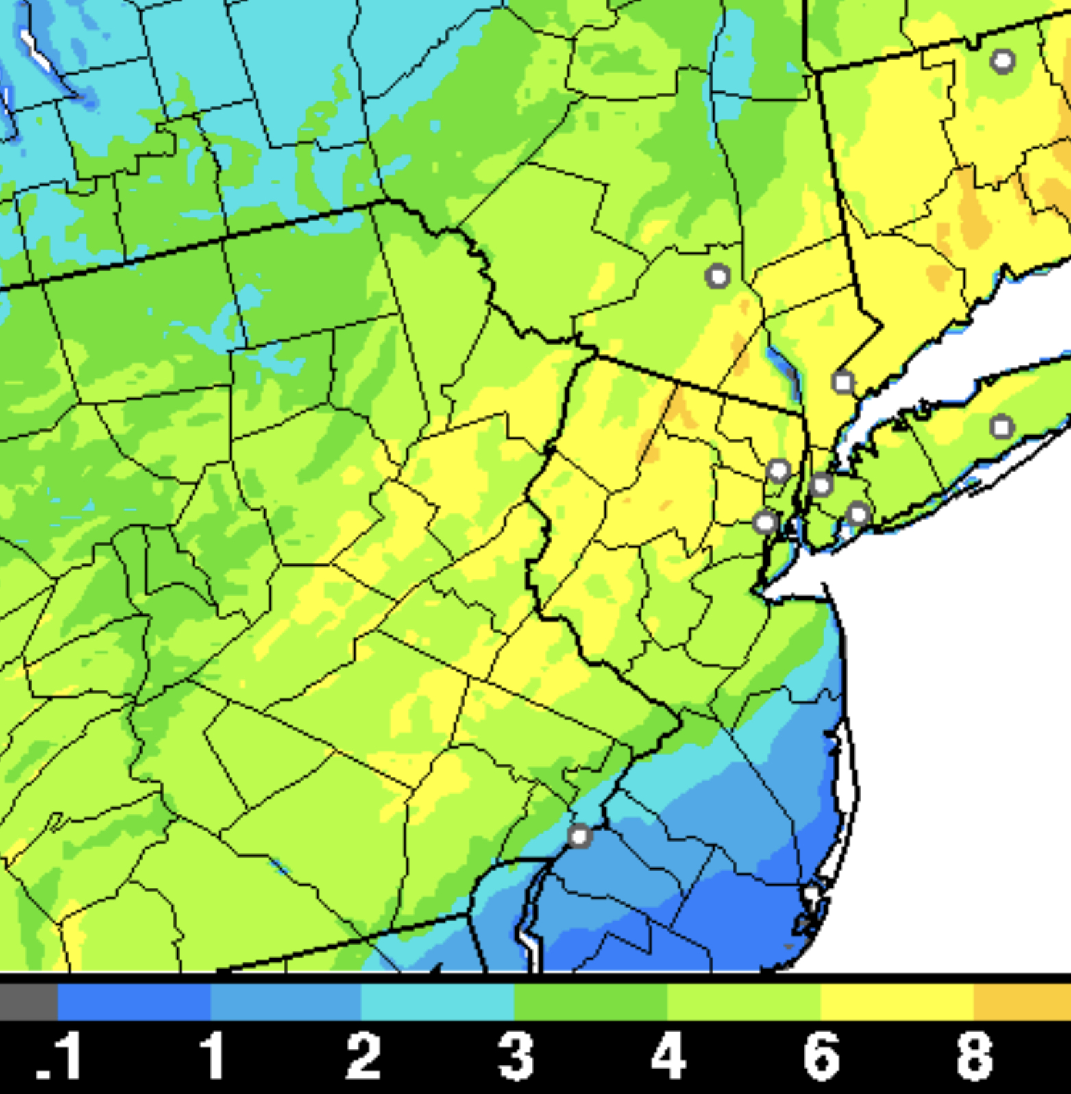
This afternoon’s NAM model (yes, the model run I would prefer not to rely on) is in.    QPF has increased to 1.26 inches water. Precipitation tapers off around 2 AM.  So, some heavy rain, even some convective rain (thunder) possible with the mix of sleet and snow.

The rain we have will mix with sleet and snow.  And it may be all-snow for a period.

No change in my forecast. The upper atmosphere remains too warm to support all-snow in much of the immediate Philadelphia area.  While some snow will fall, accumulations will be highly limited by a mixing in of sleet and rain.

The areas (in green) in the graphic below will also have significant sleet and rain, reducing the snow accumulations considerably.  If you look back at the postings of the past several days, this white line is further north and west than previous forecasts.

critical temp
White line- Critical temperatures. Northwest of the line mostly snow,  Southeast of the line, a mix of sleet, snow and rain.

Combined with temperatures that are at or above freezing at the surface, I don’t expect snow accumulations to be very impressive in the areas in green above.

Philadelphia, south NJ (east of the Delaware) will have minimal accumulation. Immediate suburbs north and west about 2-3 inches of heavy mixed snow and sleet, increasing to 7-10 inches in the far north and west. The further north and west, the more accumulation.

It’s not that you won’t see some snow in these green shaded areas, but how much can really accumulate? I guess we’ll see.

STORM UPDATE SUN 11:30 AM

Updated to include snowfall graphic

The latest NAM and GFS models have become available.  Much of  what I wrote earlier this morning still holds. Here are the trends-

Precipitation starts 2-4 PM, mostly as rain in our area, then mixes with sleet and snow. A mix of sleet, rain and snow falls for much of the storm. Temperatures at the surface are shown as above freezing by most of the statistical models.

QPF values have increased to over 1.10 inches water. (NAM) Temperatures at the surface remain above freezing according to the statistical models. The average temperatures in the lower atmosphere are at or below freezing.

Ordinarily, this would be a slam dunk major snowfall, BUT temperatures in the upper atmosphere become too warm to support snow during the heaviest QPF.

The short range models continue with a mix of sleet, rain and snow.  The changeover to all snow late in the storm occurs after the heaviest has past.

Philadelphia, south NJ (east of the Delaware) will have minimal accumulation. Immediate suburbs north and west about 2-3 inches of heavy mixed snow and sleet, increasing to 7-10 inches in the far north and west. The further north and west, the more accumulation.

Hrrr
Experimental HRRR snowfall totals

This is a tough forecast.  My regular readers of this blog know that predicting accumulation from these storms can sometimes be a choice of upper atmosphere temperatures versus lower temperatures.

Despite the snow-supportive temps in the lower atmosphere, I think the “high 500mb thickness” representative of a warm upper atmosphere will cause more rain and sleet to fall than snow in Philadelphia and immediate suburbs. I went down this wrong path in November. This storm will be a good test of the same forecast issue.

It would be easier to predict a large snowstorm for Philadelphia and the immediate suburbs but I’m not going with that at this time.