
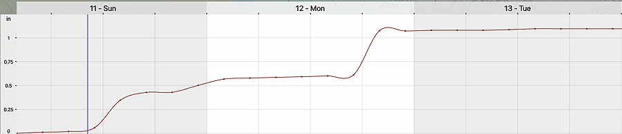
Updated Sun 9/11 10:54 PM — Additional rain, possibly heavy, will move through Monday evening. Another inch of rain, possibly two inches, may fall.
Update Sun 09/11 @ 11:03 AM — Please look at the comments link just above for some information that regulars to this blog might find interesting!
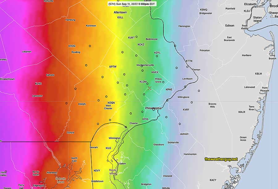
Update Sun 09/11 @ 11:02 AM — Current radar shows rain has overspread much of the area
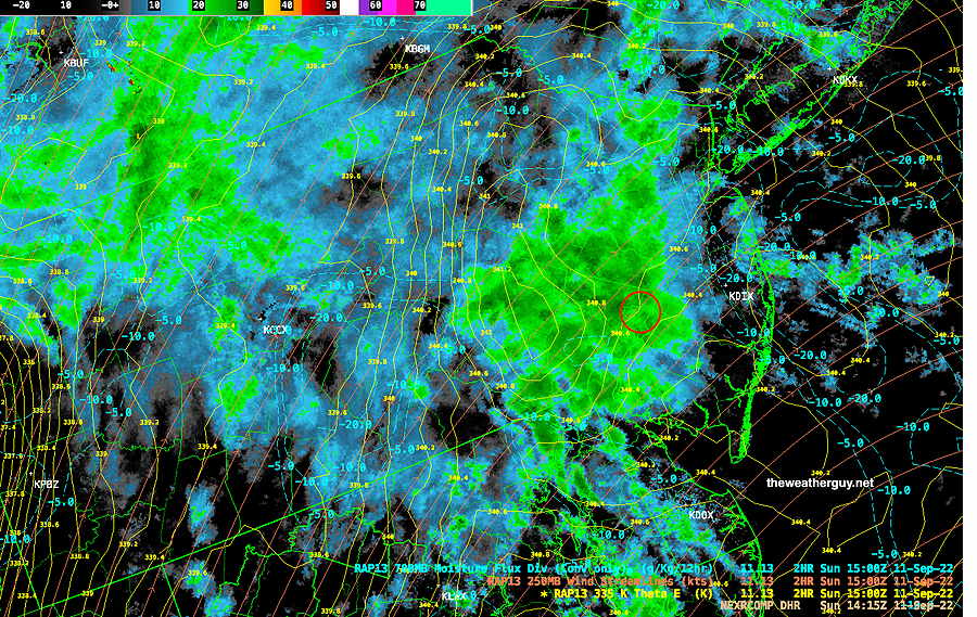
The rain should continue.
Show More
Updated Sat 9/10 10:56 PM — My usual habit of checking current radar and satellite images before a forecast update lapsed tonight. Regardless of the models, current radar shows some showers at our doorstep. So, I guess we know when the rain will start. BTW, only the ECMWF had forecast this early start. Update Sat 09/10 @ 9:43 PM — There’s still some uncertainty about the start of the rain tomorrow in the immediate PHL area. The trend has been for some showers to move in as early as daybreak or early morning. Periods of rain on and off during the day. Anywhere from 0.5″ to 1.0″ expected tomorrow through Sunday evening. Additional rain expected Monday into Tuesday. Updated Fri 9/09 10:54 PM — Tonight’s models are cranking out some moderate rain for Sunday afternoon and evening. Updated Fri 9/09 8:23 PM — A continuing change with the onset of showers on Sunday. This afternoon’s Canadian high resolution HRDPS, the German ICON, and the ECMWF models forecast an earlier start— as early as 8 AM Sunday. Our US models are still forecasting the rain to move into the immediate Philadelphia area between 12 and 2 PM. With the moisture approaching faster, expect some fog early Saturday morning before the sun burns through about 11 AM. Saturday: fog early, then sunshine by late morning. Clouds move in mid-afternoon on Saturday. (no fog today!) Sunday: Showers in western suburbs as early as Sunday morning, moving into the city around noontime. Update Fri 09/09 @ 12:41 PM — This morning’s GFS has moved towards the ECMWF with a faster approach of Sunday’s system. Saturday: Clouds move in mid-afternoon on Saturday. Sunday: Showers in western suburbs as early as Sunday morning and moving into the city around noontime. A break in the action mid-afternoon before more showers move in during the evening. Previously Posted Fri 10:50 AM — A dry flow over us will keep delightful September weather over our area through Saturday. Extensive dry flow is visible on current satellite water vapor imagery— High pressure over our area Friday and Saturday will slowly move offshore to our east as the warm front moves up from the south. By Sunday, the high pressure system will be off the coast, possibly blocking the advance of showers and rain to our south and west until late afternoon or evening— The uncertainty in this forecast will be the degree of blocking provided by the high off the coastline and the timing of the showers on Sunday afternoon or evening. The NBM (model blend) maintains the block and keeps the showers in far western areas for much of the afternoon and early evening. Here’s the NBM probability forecast for rain on Sunday at 5 PM— While several models (and model blend) keep the rain to our west for much of the day, the ECMWF has been consistently aggressive in bringing rain in as early as Sunday morning. I’m leaning towards late afternoon at this time. Sunny and pleasant. Some clouds move in during the late afternoon and evening. High temperature 82.5º sd 2.1º NBM model Blue Bell, PA Cloudy with increasing chance of rain moving in during the mid to late afternoon. (rain significantly earlier western areas) High temperature 76.7º sd 4.1º NBM model Blue Bell, PA (higher than normal sd – uncertainty) Some models have a good, soaking rain late Sunday night into Monday with rainfall about 1″

Saturday
Sunday
Hey Glenn. I am your neighbor, Pauline’s husband, and Cyan’s friend. I am also the volunteer administrator for the James Turrell “Greet the Light Skyspace” at CHFM. One of the most challenging responsibilities is predicting precipitation. We can’t open the roof and run the lighting sequence if there is any risk of precipitation during the the 65 minute window the roof is open. We try to give ticket holders a few hours advance warning if we can’t open since some travel from as far away as Washington and NYC. 85% of our programs run Sunday evenings, starting at sunset. I’m wondering if we might be able to plug into your expertise to predict the precipitation risk for our events?
Hi George, I’m sure I could provide some direct help and we should talk.
Perhaps some of the best help I could provide would be to give you some readily available online links to find the forecast rain probability. One of the best is the direct NBM (Model Blend) text output. The NBM is considered the best model for rain probability and the data is updated every few hours.
I’ve pre-configured the URL for you to provide the model output for Philadelphia Airport, Wings Field Blue Bell, and Northeast Philadelphia airport.
https://www.weather.gov/mdl/nbm_text?ele=nbs,nbe,nbh&sta=klom,kphl,kpne
While direct model output for a specific location is not available from this site, the output here is close enough for your needs.
It provides hourly probability (P01) in percentage (on an hourly basis, anything greater than 18% and increasing is meaningful) and the amount (Q01) in hundredths of an inch.
The tricky part is converting to the UTC time to Eastern standard or Eastern Daylight time. So in the example below, this is the NBM model from 0700 (3 AM) and the first row (labeled UTC) and the column labeled “14” is 10AM today.
Looking down the probability is 48% and the quantity of rain is 2= 0.02″