Last night’s model runs show a somewhat earlier approach of the rain Sunday afternoon, now expected between 2 and 5 PM, earlier far southwest of Philadelphia.
Indeed, current observations (Real Time Analysis) in West Virginia and Virginia show a larger swarth of rain now than had predicted by most of the models. The model blend has moved the precipitation earlier.
Tue 05:03 PM Update — This afternoon’s NAM-NEST, just available, has the heaviest “action” as the front moves into NJ between midnight and 3 AM. Very heavy rain and high wind gusts possible.
Tue 12:10 PM Update — Heavy rain and gusty winds. Reviewing this morning’s models, the rain will move in in two main waves.
The first round about 3-4 PM, with the possibility of some thunderstorms. Available energy (CAPE) is in the low range, so thunderstorms should be not that impressive.
The second round will be between 9 and 1 AM. The actual front moves through about midnight. Helicity values very high (>300 J/Kg) with the frontal passage, especially in western suburbs. High wind gusts (35-40mph) expected ahead of the actual front. CAPE values low, so thunder not expected with this second round.
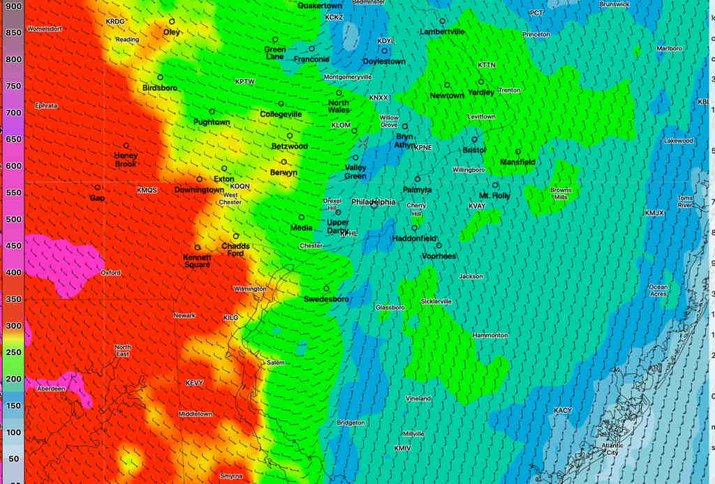
NAM NEST Helicity values at 11:30 PM Tuesday. (Click on image for a larger view.)
Total amount of rain will be 1.25-1.5 inches with some locally heavier amounts possible.
Brief Update Wed 08:55 AM — Model-predicted high temperatures in the Philadelphia area on Friday are trending warmer- a summer-like Friday! High temps most likely in the mid 80s with dew points in the 60s.
Truly summer-like weather after these unseasonably chilly past few days! It will be breezy and increasingly windy/gusty later in the afternoon.
A cold front approaches later Friday afternoon with showers and thunderstorms moving from northwest to southeast. Current predicted time frame for the showers/thunderstorms is 4 -7 pm for the immediate PHL area (NAM) but closer to 9 PM (GFS)