Update Fri @ 12:58 PM — Last night’s models continue to show showers developing in the entrance region of a jet streak as an upper airvorticity develops. The HREF on this with its simulated radar forecast superimposed on the currently forecast jet streak position—
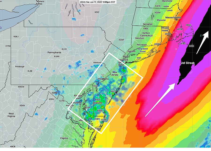
HREF forecast for 1 PM Saturday shows jet streak (enhanced wind speed of the jet stream) and the simulated radar in the white box area (the left entrance region of the jet streak.) The reason—there is enhanced upward vertical motion in this entrance regions. Notice that the position of the jet streak is somewhat further east than yesterday’s graphic, showing that the position of the showers will be further to the east than previous forecasts. (Click on image for a larger view.)
The position of the jet streak may change again and so will the forecast. Currently, most models have a mix of sun and clouds for Saturday with widely scattered showers mostly mid-day and early afternoon.
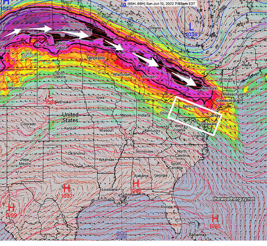
For Sunday— another jet streak approaches as a ridge in the center of the country moves eastward. This time we will be in advancing exit region of the jet streak which also has enhanced upward motion. A warm front slowly moves through with this feature and we’ll have the chance of thunderstorms and showers. Details unclear at this time. Based on the NBM, Sunday will be cloudy in the morning, then a mix of clouds/some sun and thunderstorms during the early and late afternoon. The latest models suggest the possibility of strong storms Sunday
GFS forecast for Sunday 7 PM. Another jet streak approaches along with a warm front. Enhanced upward vertical motion (this time) in the in this region will result in showers and thunderstorms. Timing details unclear at this time.
Check back for my regular “Weekend Weather Forecast” this evening.
Updated Thu 11:26 PM — Tonight’s models continue with a limited period of showers on Saturday. Not all areas will see showers. The most likely period is 11 AM-2PM. The models differ on the location, The NBM is the most aggressive with the shower coverage .
Update Thu @ 9:04 AM —The latest models have backed off considerably on the rain forecast for Saturday. A much weaker surface low expected to form, triggered by a jet stream level trough. Just some showers expected. This forecast may continue to change.
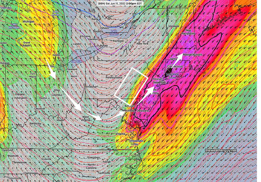
ECMWF forecast for Saturday at 2 PM. Dip in the jet stream with moderately strong jet streak places us in the “left entrance region” of the jet streak (white box), an area of upward motion. (Click on image for a larger view.)
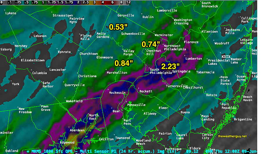
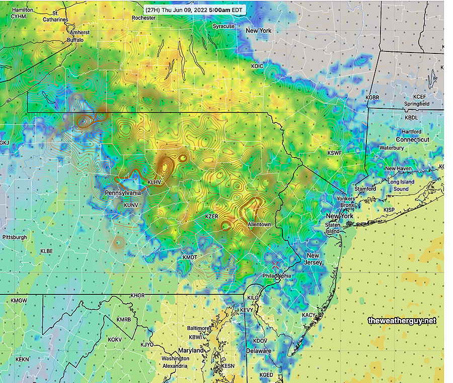
Heavy rain last night but not in the severe range. Heaviest rain axis was in our immediate area, according to the MRMS. Somewhat similar area to that depicted in the RAPensemble graphic (NARRE) below.
MRMS 24 hour precip summary (Click on image for a larger view.)
Update Wed @ 8:19 PM — This afternoon’s models continue with thunderstorms beginning about 11 PM (south of Philadelphia) and moving north through our area. This is the first of two waves of activity. Some of those storms will be strong.
HRRR forecast for 11 PM . Wave #1 approaches at 11 PM. Wave #2 moves mostly northwest of our area, but we’ll still have rain and storms with this second wave.
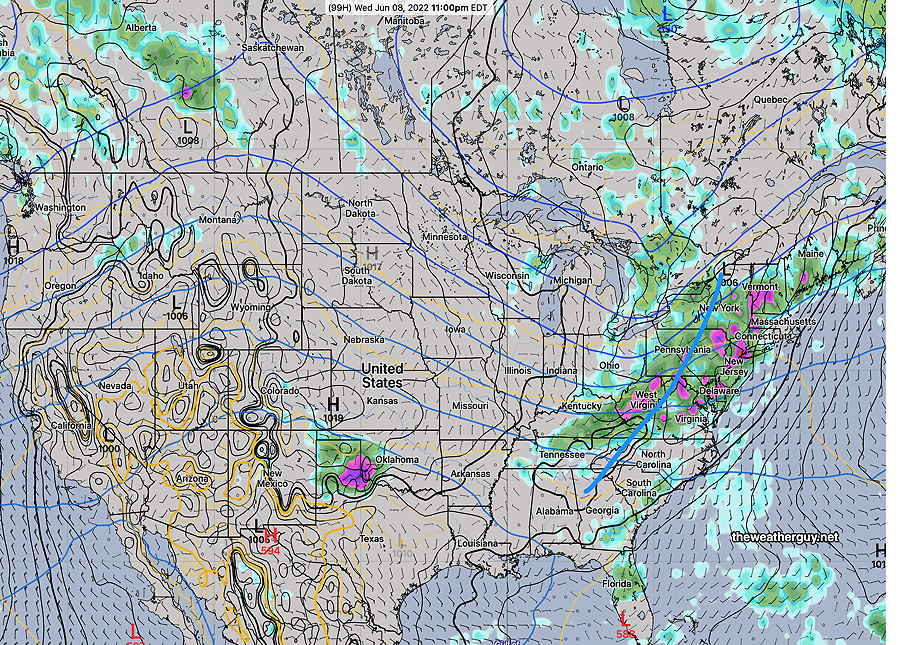
Another upper air wave moves through about 5 AM setting off additional storms. The models are still showing this second wave’s maximum impact will be in the Allentown area and far northwest suburbs.
23z RAP Ensemble (NARRE) model mean 3 hour precip at 5 AM shows general areas of heaviest rains. Displayed as 3 hour totals, final amounts will be greater. (Click on image for a larger view.)
Update Wed @ 8:17 AM — The HREF shows the highest forecast shear, CAPE and helicity will be in far northwestern suburbs about 5 AM Thursday.
HREF (06z) showing highest CAPE and Helicity, shear is near Allentown early Thursday morning at 5 AM. Heaviest thunderstorm activity will be there. (Click on image for a larger view.)
Updated Tue 10:49 PM — The NAM-NEST shows the potential for some very strong storms before daybreak Thursday. Elevated CAPE, shear, and helicity.
Updated Tue 10:17 PM — Tonight’s models are showing more impressive rainfall with Thursday’s system. A generalized 1-1.25” of rain with locally heavier amounts. Theres’s a chance of embedded thunderstorms towards daybreak Thursday.
Updated Tue 6:13 PM — A strong low pressure system north of our area is providing the windy conditions today. As has been the case recently, the heavier precipitation has been moving to our north.
Some light showers possible later this evening/tonight (Tuesday) with clearing on Wednesday. Clouds move in later Wednesday.
Yet another somewhat stronger low pressure system will move to our north on Thursday. We’ll see more rain (less than 0.4 inches) but the heaviest activity will be north of Allentown.
The same upper level jet flow with a trough will bring more showers on Saturday. Things look like they’ll clear on Sunday. Temperatures remain somewhat on the cool side.
Updated Mon 6:42 PM — The timing of forecast features has already changed considerably from yesterday’s post.
The latest GFS show some showers late Tuesday afternoon with a warm front. Skies now mostly clear on Wednesday, with a chance of widely scattered showers. A cold front associated with low pressure will bring rain, possibly briefly heavy, late Wednesday night and before daybreak on Thursday.
Another low affects us over the weekend; the exact timing may change, as did this week’s forecast. Stay tuned.
Previously Posted Sun 5:43 PM —
Following a picture-perfect weekend, the coming week looks more unsettled as a ridge builds on Tuesday with a cold front moving through Wednesday with considerable showers and thunderstorms. (The latest ECMWF shows some showers as soon as late Tuesday afternoon.)
GEFS jet stream wind forecast (250 mb) for Tuesday at 5 AM showing weak upper ridge over the Northeast. (Click on image for a larger view.)
For Wednesday—
ECMWF forecast for Wednesday showing considerable rain/thunderstorms ahead of a cold front. (Click on image for a larger view.)
After the cold front, the upper winds become a trough by Thursday—
GEFS jet stream wind forecast (250 mb) for Thursday at 8 PM showing the upper ridge has now transformed to a weak trough. (Click on image for a larger view.)
It should be noted that the ECMWF has a much sharper trough moving through with considerably more rain for Wednesday than the GEFS.
Unfortunately, another disturbance is poised to move in for part of next weekend.