Tag Archives: Hurricane Milton

THIS WEEK’S WEATHER

#Philadelphia #weather #PAwx #Milton

Hurricane Milton Update

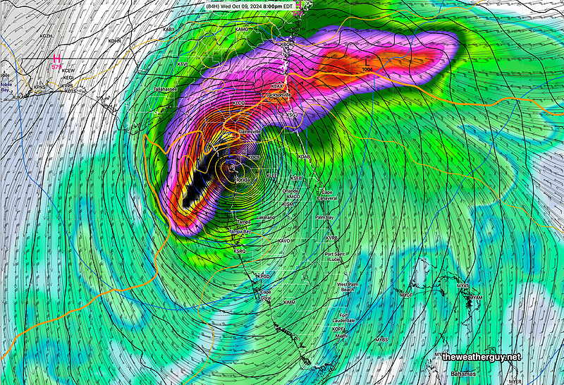
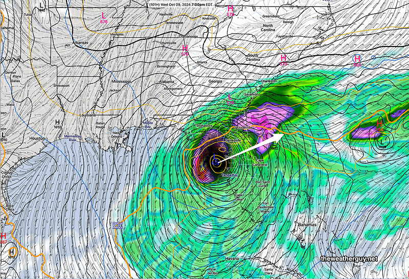
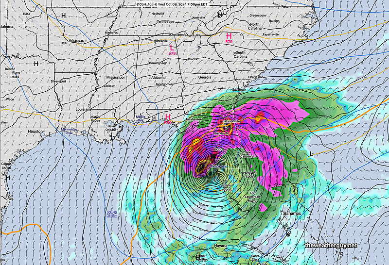
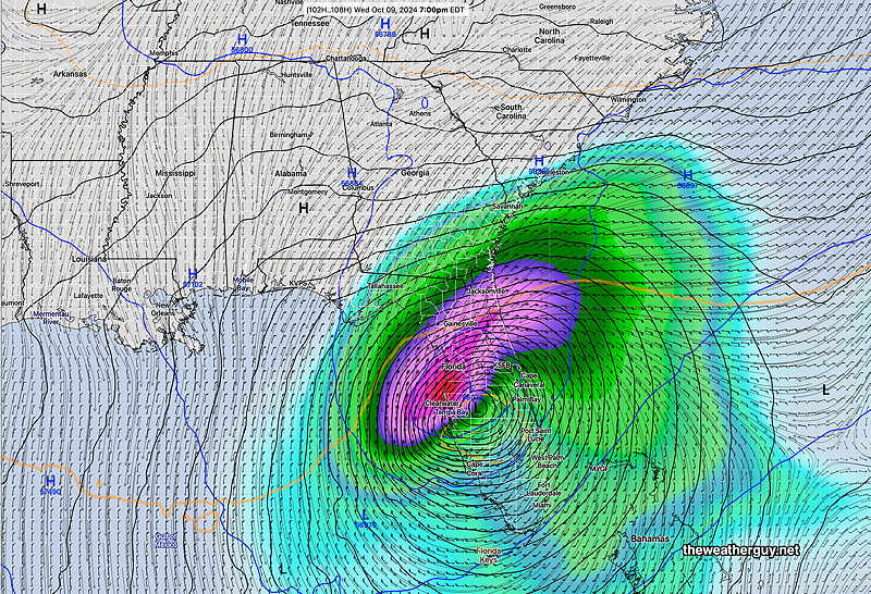
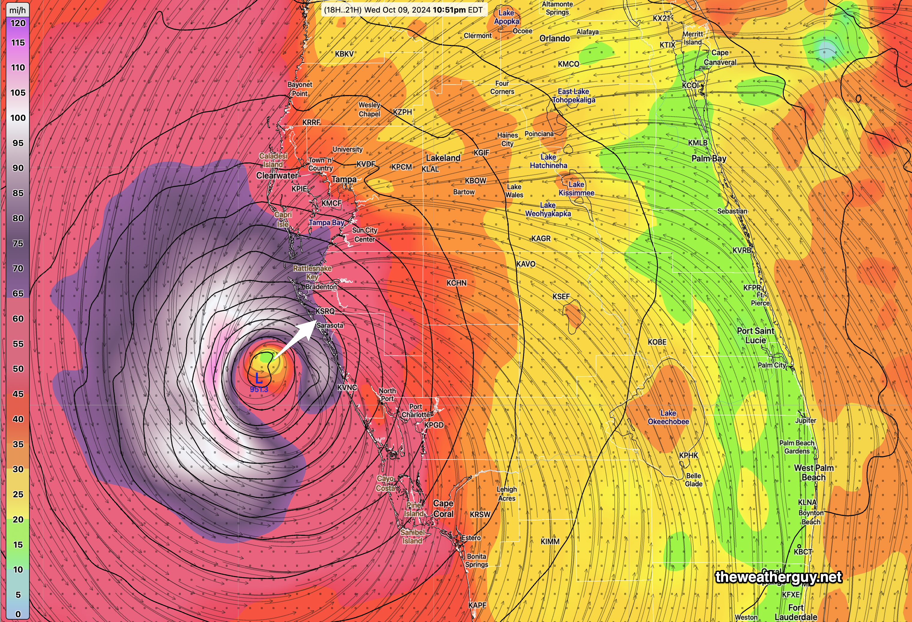
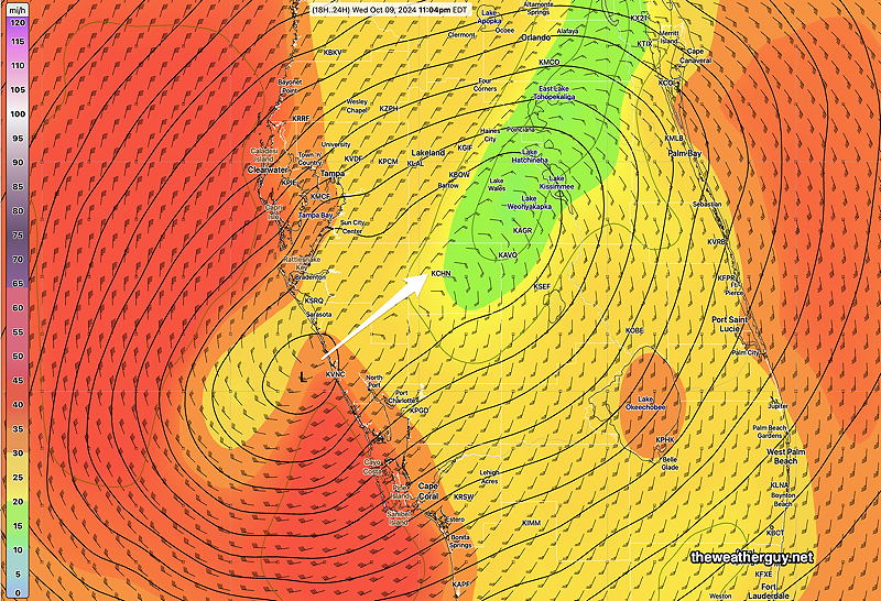
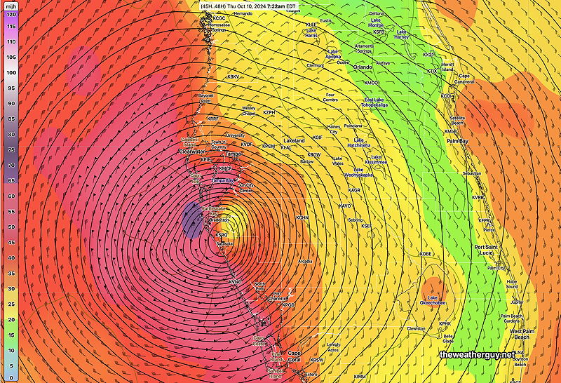
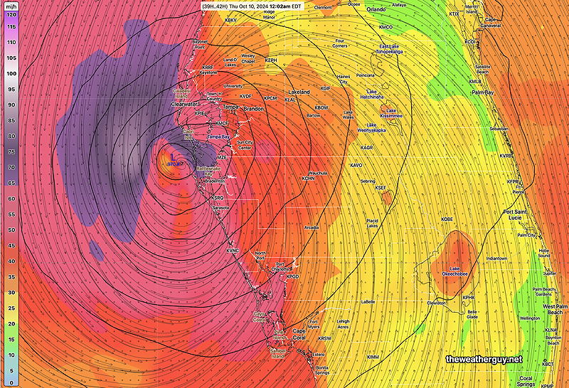
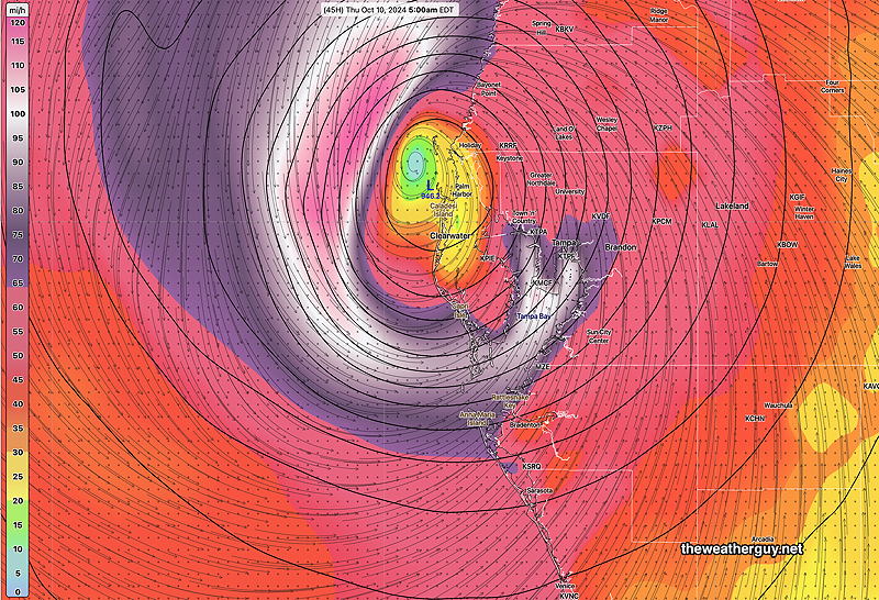
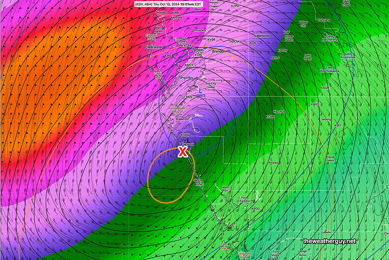
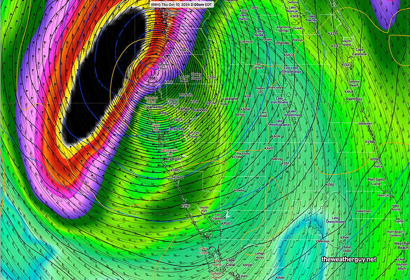
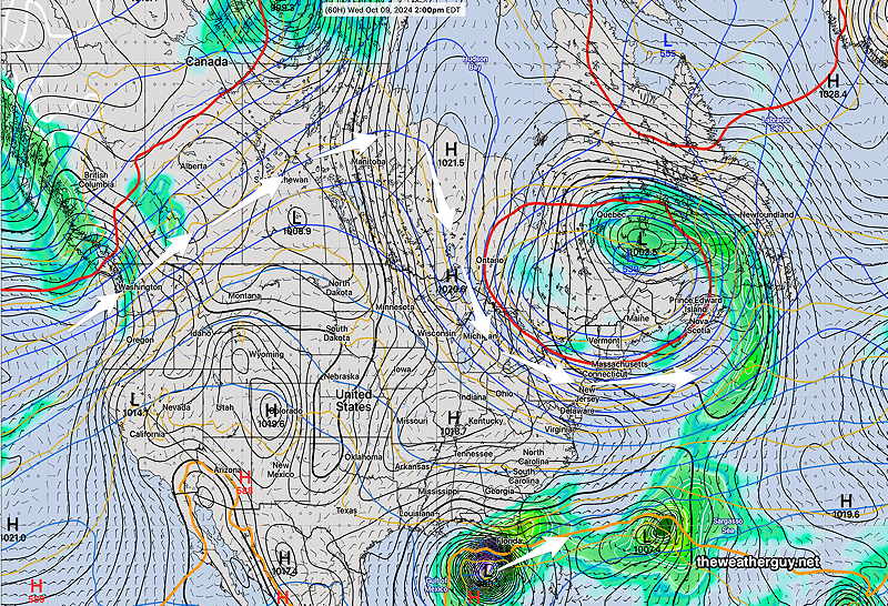
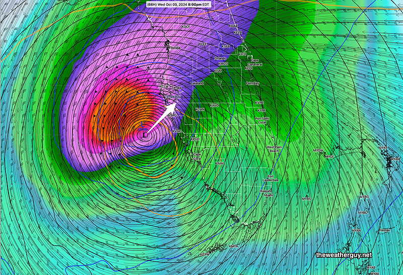
Posted Wednesday 10/09/24 @ 4:31 PM —The latest models are suggesting Milton will make landfall between 11 PM and midnight, just south of Tampa Bay, possibly closer to Sarasota—

12z HAFS B wind/pressure forecast for 11 PM tonight. Landfall between Sarasota and Tampa Bay. (Click on image for a larger view.)

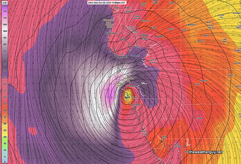
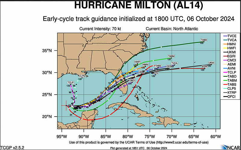
There remains uncertainty in the exact location of landfall. Here’s a few models—

Milton Landfall – various models (Click on image for a larger view.)

Hurricane Milton Update

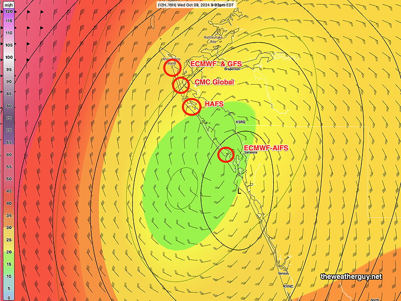
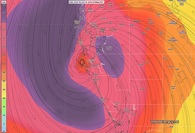
Posted Wednesday 10/09/24 @ 9:55 AM —Both the latest ECMWF AI model and NOAA’s newest hurricane model, the HAFS B, has Hurricane Milton making landfall between 10 PM and midnight south of Tampa Bay, closer to Sarasota

The latest HAFS B model wind/pressure forecast for ~10 PM tonight (Click on image for a larger view.)

Here’s the ECMWF-AIFS has been consistent with this landfall location—

06z ECMWF-AIFS wind/pressure forecast for ~ 10 PM tonight (Click on image for a larger view.)

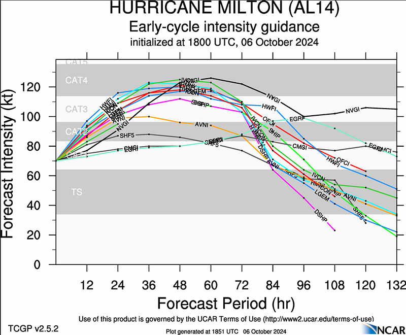
The hurricane intensity models all have Milton downgrading to a Category 3 before it makes landfall.

A landfall south of Tampa Bay may be better for the Bay area as wind flow will be westward instead of eastward in that region. It will be worse for Naples, Venice, etc.


Hurricane Milton Update

Posted Tuesday 10/08/24 @ 4:27 PM — The latest ECMWF has delayed Milton’s landfall until 7 AM Thursday morning, closer to Sarasota. The AI version is similar—

12z ECMWF Milton landfall around 7 AM Thursday morning just north of Saratoga (Click on image for a larger view.)

NOAA’s newest hurricane model, the HAFS B has an earlier landfall further north near Tampa Bay—

12z HAFS B forecast for midnight Wednesday into Thursday morning. (Click on image for a larger view.)

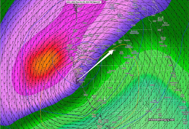
Posted Tuesday 10/08/24 @ 3:00 PM — Today’s models have trended towards a somewhat later landfall for Milton, sometime in the early morning hours of Thursday.

Here’s NOAA’s high resolution Hurricane model, the HWRF, one of several NOAA hurricane-specific models—

Todays 12z HWRF model wind speed and surface pressure forecast at 5 AM. Notice the northward track of this model. with landfall north of Clearwater. (Click on image for a larger view.)

There’s still a range of landfall predictions and there’s no reason to believe this is the correct one.


Posted Tuesday 10/08/24 @ 10:41 AM — The latest ECMWF-AIFS model shows Hurricane Milton reaching landfall just before midnight Wednesday into Thursday near Sarasota. This AI model has been extremely consistent in forecasting this storm and consistent about its track.

10-08-24 06z ECMWF-AIFS forecast for Thursday at 12:01 AM. Rainfall shading (Click on image for a larger view.)

In contrast, the GFS is slightly north, directly entering Tampa Bay—

10-08-24 06z GFS Winds at 12:28 AM Thursday. Slightly north of the ECMWF-AIFS, forecast track, entering Tampa Bay. (Click on image for a larger view.)

Hurricane Milton Update

Posted Monday 10/07/24 @ 5:20 PM —The latest ECMWF-AIFS has become available. I’m leaning towards this model because it was the first to forecast this hurricane over a week ago and it did quite well with forecasting Helene’s track.

The latest ECMWF-AIFS takes the storm just north of Sarasota about 10 PM to midnight Wednesday—

10-07-24 12z ECMWF-AIFS forecast for 10 PM Wednesday evening. Shading is rainfall rate. (Click on image for a larger view.)

Note that our GFS model is significantly further north with Milton’s landfall and is somewhat slower, making landfall about 2 AM Thursday—

10-07-24 12z GFS has a track further north and somewhat slower, reaching landfall north of Clearwater at 2 AM Thursday. (Click on image for a larger view.)

The operational version of the ECMWF is closer to the GFS than it’s own AI version.

Just an acknowledgement that this is a dynamic situation, no single model should be relied upon and the official information from the National Hurricane Center should be utilized.


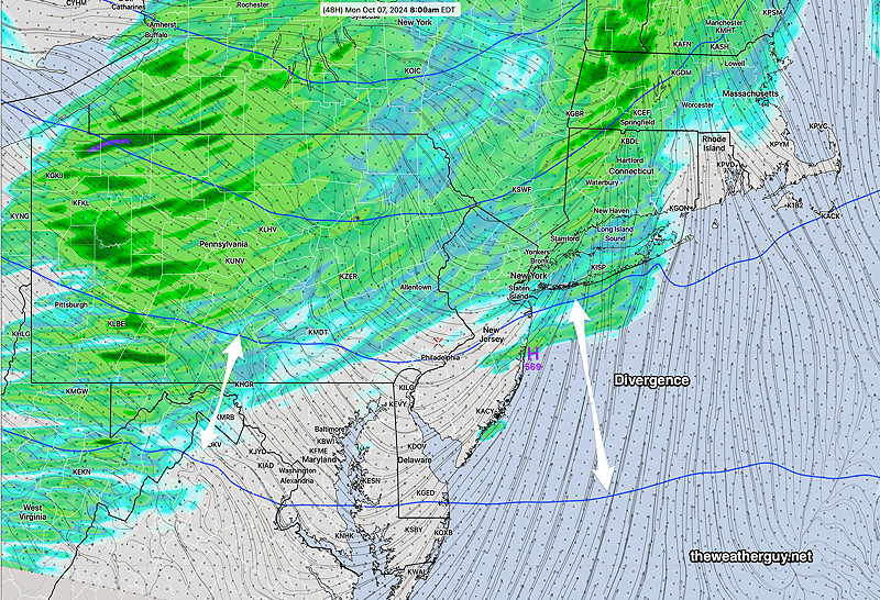
Quiet Here Weather-wise. And then there’s Milton

If I had some time off as a meteorologist in the northeast, this week would be a great time to take an extended vacation.

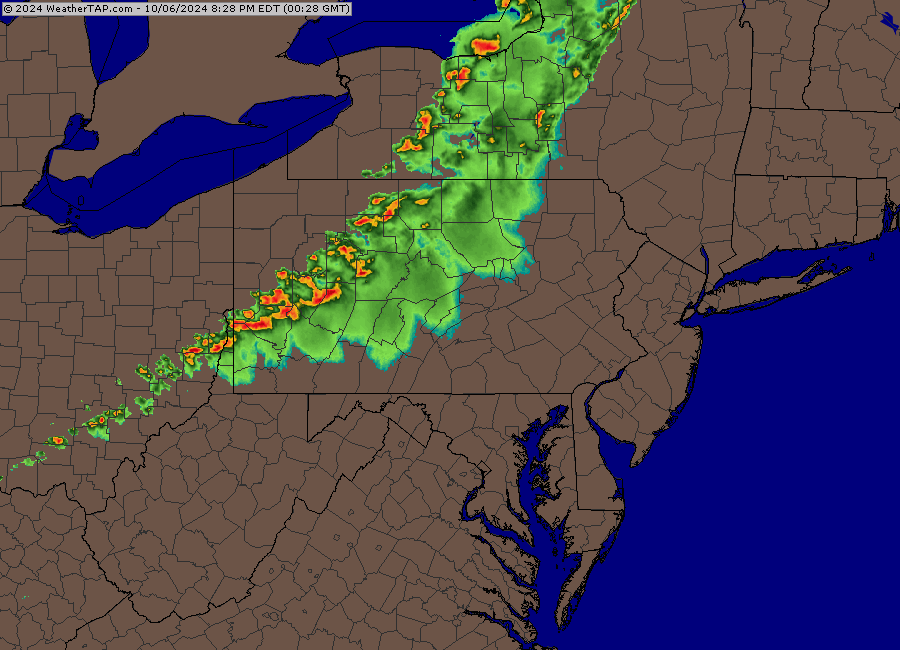
Fair weather and no significant rainfall for our area for at least a week!

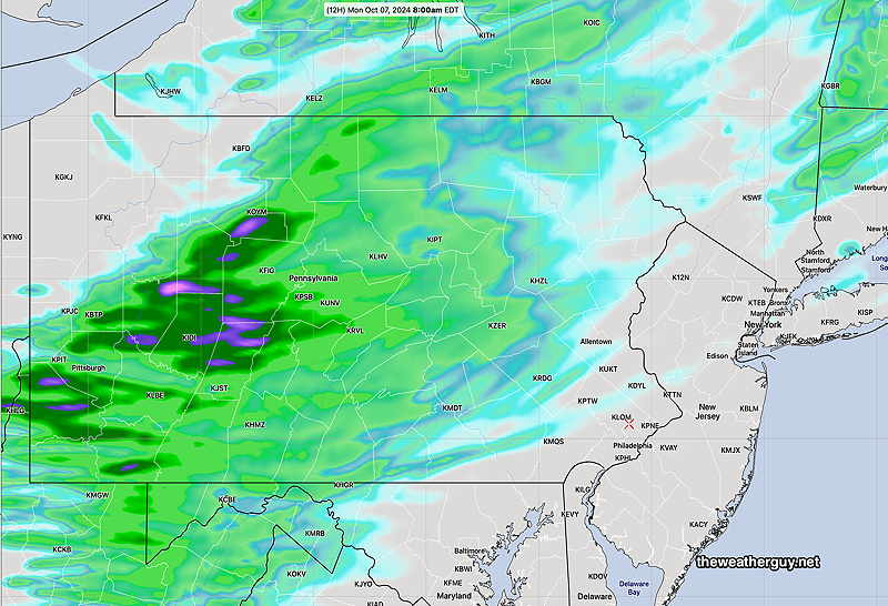
A very amplified high pressure ridge will fill the central and western US while the northeast will be under the influence of an upper trough—

Monday morning Water Vapor image with superimposed RAP model parameters. Upper trough over our area, strong blocking ridge over the central and western US. Hurricane Milton visible. (Click on image for a larger view.)

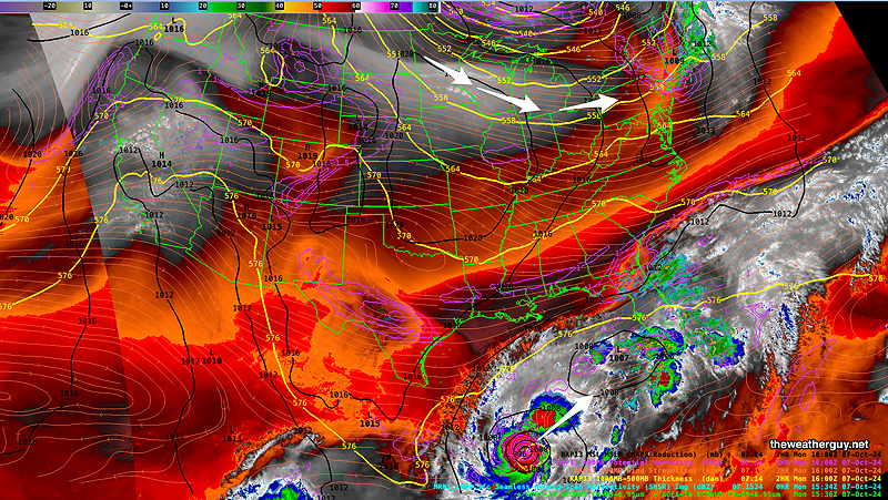
By Wednesday, the upper low closes off to our northeast and nothing but dry high pressure is available to affect our weather—

NAEFS forecast for Wednesday at 2 PM. Large ridge and high pressure to affect our weather. (Click on image for a larger view.)
Hurricane Milton

The ECMWF AIFS had successfully predicted the formation and likely track of what is now known as Hurricane Milton well over a week ago. It did this long before the regular models showed any specific development. It also was very successful with the general track of Helene.

The ECMWF-AIFS latest run shows the following possible landfall between 8 PM Wednesday and 1 AM Thursday—

10-07-24 06z ECMWF-AIFS forecast for Hurricane Milton at 8 PM. Milton shows signs of weakening somewhat as it approaches south of Tampa Bay. (Click on image for a larger view.)

More updates on Milton later today.


WEEKEND WEATHER FORECAST

#Philadelphia #weather #PAwx

Sunday Night Rain Update

Posted Sunday 10/06/24 @ 9:44 PM — Current radar suggests some heavy rain moving into Philadelphia after midnight. It would be wrong.

Radar Sunday night at 9:40 PM (Click on image for a larger view.)

Here’s the latest HRRR, just available —

10-07-24 00z HRRR total rainfall for tonight. (Click on image for a larger view.)

Every high resolution model has this line of storms falling apart by the time it gets to Philadelphia. I’m going with the models, not the radar. We’ll see what happens.

I often chuckle when the TV weather people too frequently use the expression “I’m tracking the storms”. Weather is dynamic, not a train. On this blog, I avoid that expression like the plague.


Hurricane Milton Update

Posted Sunday 10/06/24 @ 3:14 PM —The latest model guidance is forecasting a major hurricane for the west coast of Florida. There is some question about the timing and exact point of landfall, but the intensity looks to be at least a Category 3 or likely a Category 4 storm.

The latest GFS has a northern track, further north than several other models—

10-06-24 12z GFS forecast pressure/rainfall 8 PM Wednesday evening.

Milton looks to be a fast moving but dangerous storm.


Sunday Forecast Update

Posted Sunday 10/06/24 @ 8:55 AM — While some of the lower resolution global models (GFS, ECMWF) still show a line of showers after midnight in our area from a cold front, the higher resolution models (HRRR, RRFS, NAM-NEST, HRDPS,) show very spotty rainfall with low or no rain accumulations in many areas.

Here’s the NAM-NEST forecast total rainfall —

10-06-24 0tz NAM=NEST total rainfall Sunday night (Click on image for a larger view.)

Here’s the HRRR total rainfall forecast for tonight—

10-06-24 06z HRRR forecast rainfall for tonight (Click on image for a larger view.)

Either way, not much in the way of rainfall. The reasons are discussed below.

Hurricane Milton

Posted Saturday 10/05/24 @ 7:55 PM — A new tropical system has developed in the Gulf, likely to intensify and be named Hurricane Milton.

Those following this blog know that the ECMWF-AIFS has been forecasting this development and track for days. While I hadn’t posted the German ICON model, it too was an early forecaster of this system.

The several runs of the GFS have jumped on board with a forecast track that would affect areas recently hurt by Hurricane Helene.

Here’s the latest GFS with a central pressure of 954 mb, likely at least a Category 2 , possibly Category 3 storm —

Today’s 18z run of the GFS. Forecast time is 7 PM Wednesday Central pressure 954 mb (Click on image for a larger view.)

The latest German ICON is further south and slower —

Today’s 18z German ICON model forecast for 7 PM Wednesday. (Click on image for a larger view.)

This morning’s ECMWF is a bit further south (as is the Canadian Global) with this storm—

Todays 12z ECMWF forecast for 7 PM Wednesday. Central pressure 969 millibars. (Click on image for a larger view.)

The model that has been forecasting this for almost a week, the artificial intelligence/machine learning model has a track further south and a bit faster with landfall—

Todays’ 12 ECMWF-AIFS forecast for 7 PM Wednesday (Click on image for a larger view.)

Hurricane Tracks often change and I expect changes in these model forecasts. But a strong system to affect parts of Florida looks high probability.


Update Sat 10/05 5:38 PM — Watching the Phillies game and “doing the weather”. The latest models do show a hurricane at least Category 2 moving into central Florida from the western Gulf. More details after the game


Originally Posted Sat @ 12:27 PM — —Beautiful weather for this weekend. The chance of rain has significantly diminished for our area for Sunday night.

Why are we not getting any rain?

People have asked why we’re not getting rain. The reason is a persistent lower and upper level high pressure system, that both blocks the rainfall and results in downward vertical motion in our area.

More importantly, this persistent high pressure has caused the jet stream to be to our north, resulting in upper level downward motion unfavorable for rain in our area. My conjecture is the global warming has caused the resulting warmer air mass to be larger resulting in a more northern jet flow, along with a smaller air mass of colder air to our north.

As a result, we’re in the in an area of both upper air divergence and the we’re also in the “right exit region” of the jet streak.

Here’s the latest HRRR. Notice the increasing divergence of heights of the 500 mb winds resulting in downward motion and diminishing chance of rain in our area. (Click on image for a larger view.)

Additionally, we’re located south of the jet streak, specifically in the right exit region, also resulting in downward motion unfavorable for rain in our area—

The right exit region has downward motion

The right exit region 2 AM Monday morning. Downward motion in our area. The terms entrance and exit regions are very confusing and not intuitive. (Click on image for a larger view.)

Here’s the HRRR predicted total rainfall for Sunday night. The upper level divergence and position of the exit regions affect our rainfall —

Total rainfall expected Sunday night into Monday. Little to no rain again for us! (Click on image for a larger view.)

I’ll be updating this page about the the likely hurricane to affect Florida later today. (It appears the AI model of the ECMWF has been the first to identify the likely storm. I should note that the German ICON model has been forecasting something similar for several days. )

Check back later today.