Posted Sunday 01/14/24 @ 6:40 PM — Watching the Cowboys lose and waiting for tonight’s NAM run.
Here’s the trend. This storm has become more interesting, as some of the precipitation may mix with sleet and rain from the city eastward on Tuesday morning before ending, limiting the total snow depth for the storm. Models are ranging from a generalized 1 inch total (GFS), 1-2 inches (ECMWF) and 2-3 (NAM)
I’ll be updating after the next NAM before 10 PM.
Sunday & Tues Snow Update
Posted Sunday 01/14/24 @ 10:21 AM — Just a quick update. The arctic front is in central PA and will move in with rain showers followed by a quick changeover to snow flurries. Timing is about noon to 3PM. The most activity may be north of the Philadelphia area. Increasingly windy and gusty through the daytime hours. High winds about 2 -3 PM.
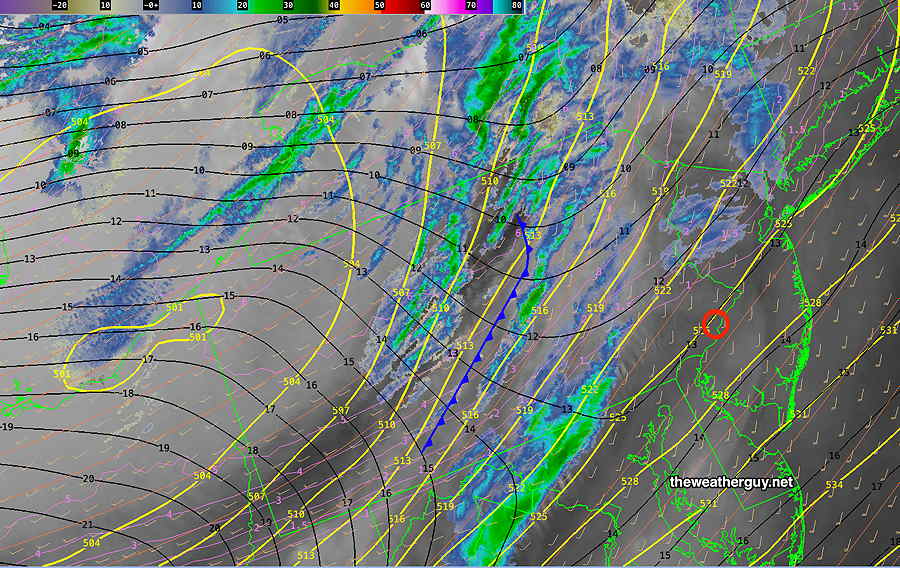
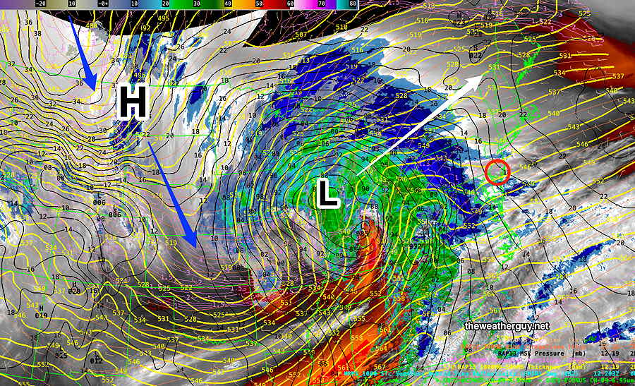
Current satellite water vapor image with superimposed RAP model 500-1000 mb thickness lines (yellow), Mean Sea Level Pressure isobars (black contours) potential vorticity (fine violet contours) with superimposed MRMS RADAR. Front is in central PA at 10 AM
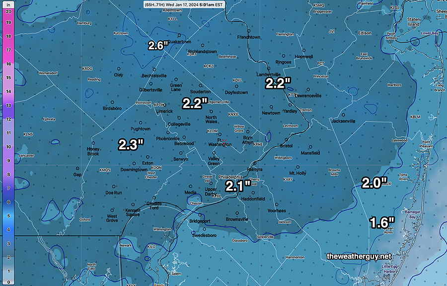
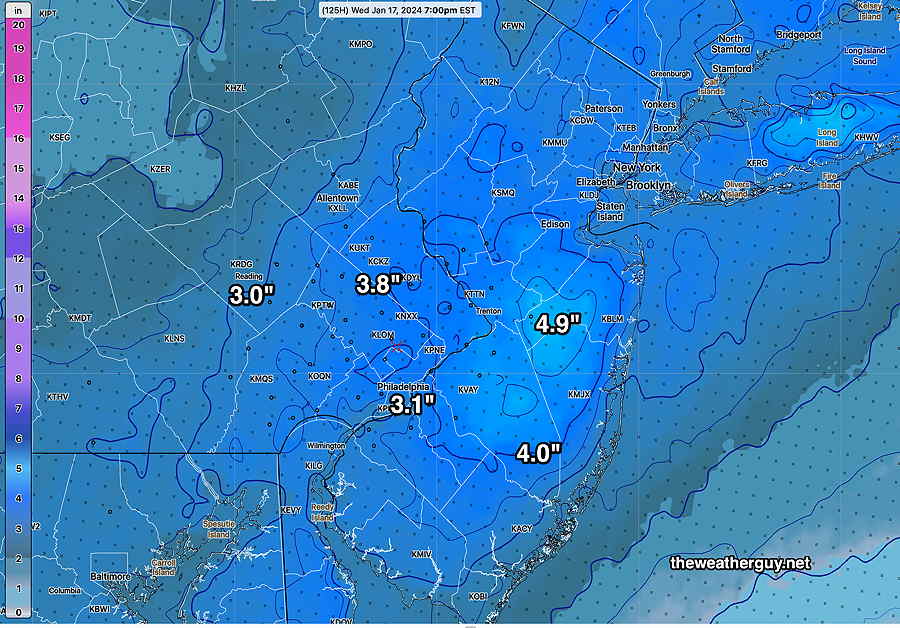
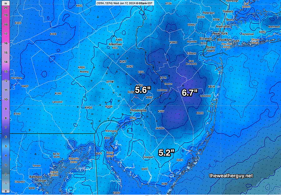
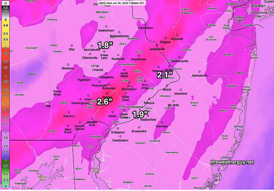
As for the snow late Monday into Tuesday, most models have come together with a generalized 2-2.5 inch snowfall. More specifics later this afternoon. Here’s the latest 13z NBM model snow total forecast—
Sunday Forecast Update
Posted Saturday 01/13/24 @ 9:48 PM — The sharp arctic front moves through with strong winds, dark clouds, and a fast moving squall-type line that may start as rain showers but likely ends as snow showers. It’s forecast to move through 11AM west 1 PM east.
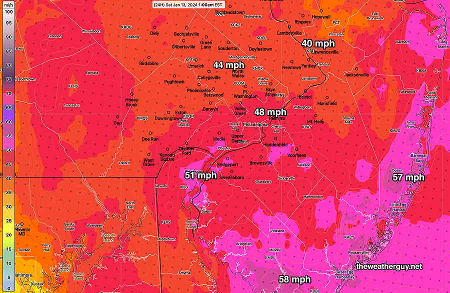
Wind gusts 40-50 mph as the front approaches and continues through much of Sunday afternoon.
Regarding the system(s) that approaches late Monday, it’s becoming clear that the models are having trouble with the forecast because the energy is divided between two jet flows. The northern system will result in some snow Monday night into early Tuesday morning. About 1-2 inches of snow are likely by Tuesday morning. The southern stream system, which has much more moisture, will move mostly to our east.
The NAM, German ICON and Canadian models are the most aggressive with the snowfall totals. Here’s the latest NAM, just available—
01-14-24 00z NAM snow depth forecast by 10 AM Tuesday. (Click on image for a larger view.)
The NAM above only forecasts out to 84 hours, so additional snow after that point isn’t shown.
Here’s the latest model blend (NBM) which forecasts out much further in time—
01-14-24 00z NBM snow totals by early Wednesday morning (Click on image for a larger view.)
I still expect these forecasts to change over the coming days. This dual system is more difficult to model than most. Stay tuned.
Snow Outlook
Posted Saturday 01/13/24 @ 4:02 PM — It looks like we’re going to have a snow squall come through about 11 AM to 1 PM from west to east on Sunday. A fast burst of snow showers with gusty winds even though temperatures will be well above freezing.
The models are back to predicting about 1-2 inches of snow in our area, starting Monday evening from a coastal system. (The latest NAM shows somewhat more snow in some areas.) Still a low confidence forecast.
Update
Posted Saturday 01/13/24 @ 11:10 AM — These showers moving through at this morning were shown on last night’s 06z models. Somehow, I got caught up in the Tuesday snow forecast and I didn’t look last night’s forecast for this morning. (Gee, I hope I don’t lose this job!)
Anyhow, now that the showers are moving through, I reviewed which models captured it. Last night’s 00z models (7 PM EST) didn’t show much. The 06z models (1AM EST) did.
BTW, I’ve been paying considerable interest in the beta version of the RRFS model being developed; the NOAA Model Development Group is using AWS to distribute these experimental model runs.
The RRFS is far from perfect, but some of its forecasts regarding light rain seem to be at least as good (light rain) or better (cloud cover) than the HRRR. It’s still at beta version 0.77 and may not become operational until late 2024 or very early 2025.
Anyhow…
For Sunday, the arctic front moves though between 11 AM and 1 PM Sunday with some snow flurries. Windy with plummeting temperatures.
Regarding the Tuesday forecast, the Tuesday period has just come into the range of the NAM model. The NAM does show some precipitation here but interestingly, it shows it too warm resulting in a light mix of rain sleet and snow. So, there’s still an uncertain forecast for Tuesday’s storm.
Posted Saturday 01/13/24 @ 9:04 AM — One more thing. It does appear we will have a line of snow flurries move through Sunday, about noontime with the arctic cold front expected to pass through. Temperatures plummet in the afternoon. The rest of the weekend forecast posted yesterday remains intact.
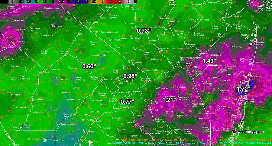
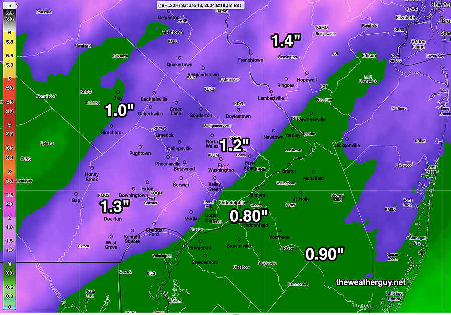
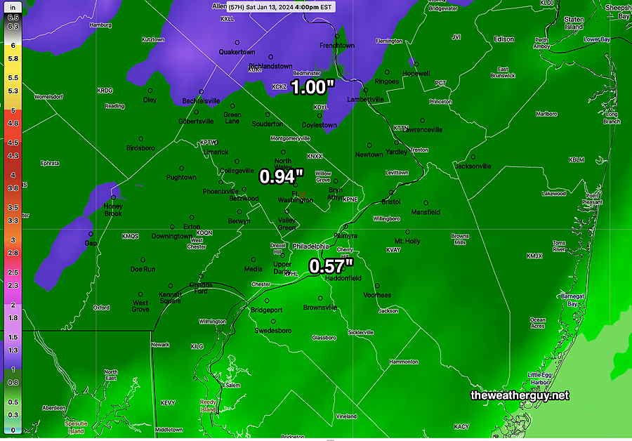
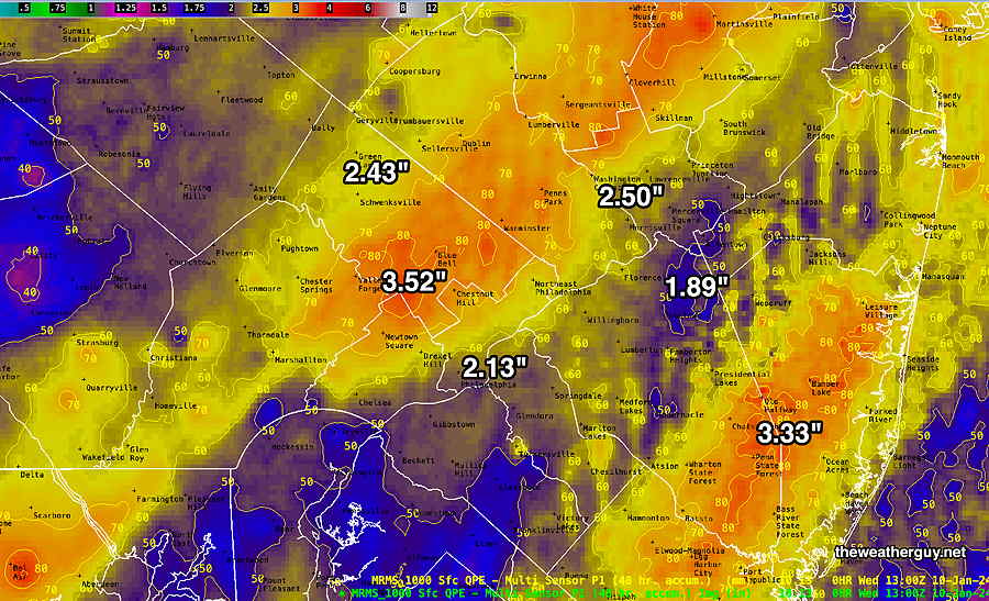
Sat 8:43 AM —Forecast Review — This storm wasn’t modeled as well as the last and wasn’t as severe. (luckily) We had the first clue when Friday had much more sunshine than had been forecast and the rainfall started two hours later than originally forecast. Looking as this morning’s MRMS rainfall totals, the banding of heavy rain set up in NJ, not west of Philadelphia as had been forecast. Based on the debris in my garden, it doesn’t look like the winds were as strong as had been predicted either.
MRMS combined rain gauge & radar-based measurement of rainfall received. Color shading is in inches. Line contour numbers are in mm (25.4 mm= 1 inch) (Click on image for a larger view.)
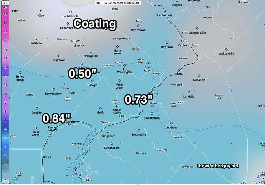
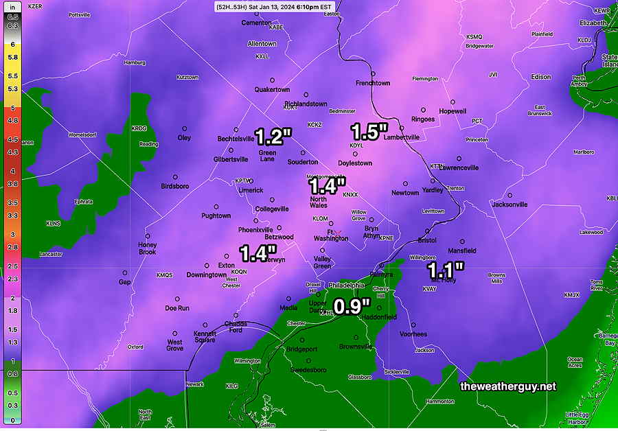
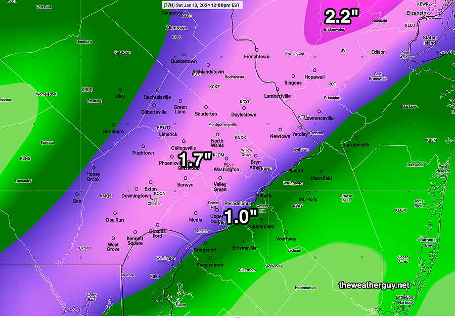
Posted Saturday 01/13/24 @ 8:51 AM — Speaking of forecasts, the snow storm that was a possibility for Tuesday is looking to have a more eastward track. The ECMWF was forecasting this from the start. As a result our area now looks to get only a coating to an 3/4 of an inch of snow on Tuesday. So forget about those snow totals I knowingly posted prematurely yesterday. Some models (Canadian, German ICON) still show somewhat heavier snow, so the forecast remains uncertain.
Here’s the latest GFS snow forecast which shows generally a coating. From experience, low snow totals in this range can mean virtually no accumulation
01-13-24 06z GFS snow totals Tuesday morning. Quite a change! (Click on image for a larger view.)
Previously Posted Fri 5:10 PM —
Deep low pressure will move into the Great Lakes area with another round of rain and winds tonight (Friday) —
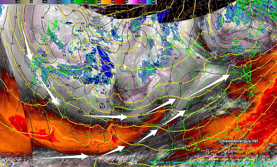
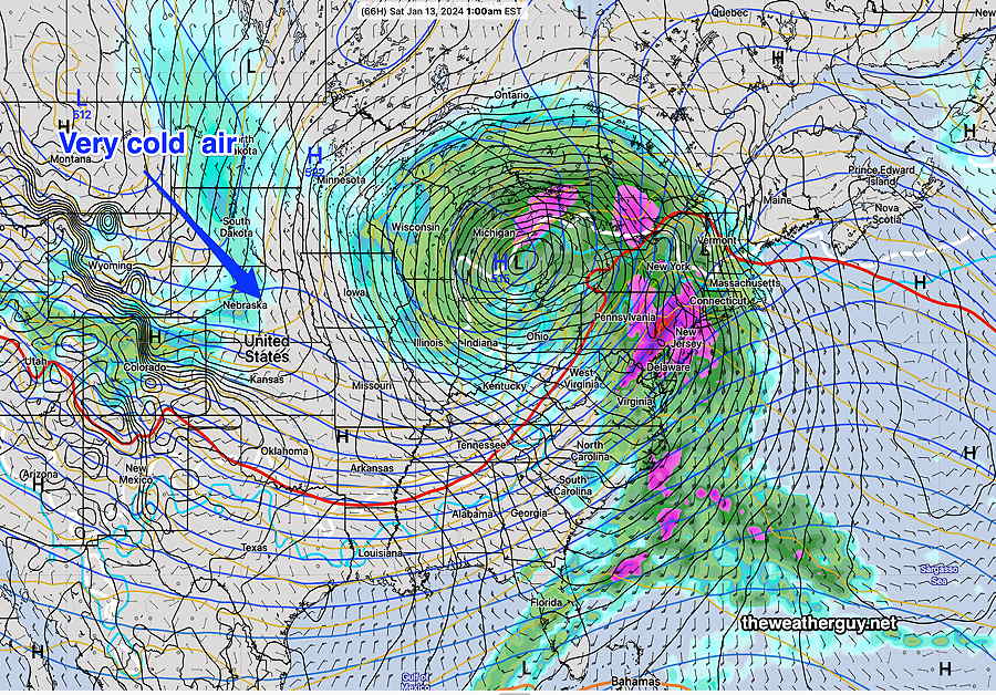
Current satellite water vapor image at 4:00 PM Friday with superimposed RAP model 500-1000 mb thickness lines (yellow), Mean Sea Level Pressure isobars (black contours) potential vorticity (fine violet contours) with superimposed MRMS RADAR. The low will track to the Great Lakes and pull a cold front through Saturday morning. Very cold high (H) pressure sinks southward. The pressure gradient between the deep low and the cold high will cause windy conditions on Saturday and Sunday.
Friday Night – Saturday
Clouds moved in somewhat later than had been forecast on Friday and the rain start may be delayed until 8-10 PM. The NBM is still forecasting similar amount of rainfall in a very short period of time—
Latest 18z NBM total rainfall tonight. (Click on image for a larger view.)
Winds will increase towards midnight and be gusting 40-50 mph by 1AM, and will remain gusty into Saturday.
The rain ends Saturday morning before daybreak and there will be very gradual clearing. Plenty of clouds in the morning, perhaps with some sunny breaks. Still more clouds and sun in the afternoon.
Temperatures will be falling throughout the day, from a high in the 50s early morning to near 30º by evening. Quite windy with gusts near 40 mph throughout much of Saturday.
Sunday
A secondary cold front moves through Sunday morning with considerable cloudiness and gusty winds. Scattered snow flurries are looking likely as the front moves through mid-day. A mix of clouds and some sun Sunday afternoon and continued windy. High temperatures again early, about noon and then falling.
Late Tuesday into Wednesday Possible Snow
There’s still considerable spread regarding the forecast of a coastal storm Tuesday into Wednesday. I’ll be covering it over the weekend, but current best guesses is 2-5 inches on our area.
It’s really too soon to be posting this and it will certainly change—
01-12-24 19z NBM model forecast snow depth by Wednesday evening. (Click on image for a larger view.)
Check back over the weekend for updates. BTW, there’s a chance of another storm next Friday into Saturday.
Posted Friday 01/12/24 @ 7:29 AM — First, tonight’s rainstorm. No significant changes seen in the forecast for tonight’s flooding rains. The rainfall map from last night’s models is similar and the high wind gusts expected also similar.
Here’s the wind gusts expected at 1 AM Saturday morning—
01-12-24 06z NBM model forecast mean wind gusts at 1 AM Saturday morning. (Click on image for a larger view.)
Friday evening, rain moves in between 6:30 PM and 9 PM from southwest to northeast. It’s a fast moving system and the rain ends before daybreak, possibly with a few lingering sprinkles early morning.
A mix of clouds and perhaps some sunny breaks Saturday morning. Considerable cloudiness early afternoon, then more sunshine by mid to late afternoon. WINDY.
Snow Storm Tuesday?
Several models, with the noted exception of the ECMWF, are predicting a coastal low to intensify and bring mostly snow to our region. The storm is still 120 hours in the future and only in the range of the global models and their ensembles.
I know there are plenty of snow lovers who follow this site and I’m providing a snow accumulation graphic below just to give an idea of what I think is possible.Way to early to take this literally and with the ECMWF not buying into the snow forecast, this is a low confidence situation—
01-12-24 06z NBM based snow accumulation calculation through Wednesday evening. (Click on image for a larger view.)
Beginning tomorrow (Friday) morning, I’ll be covering that potential Tuesday snowstorm here; the chance of a significant snowstorm, especially for western and northern suburbs, has moved from speculation to possible.
Friday Rain Storm
Posted Thursday 01/11/24 @ 5:51 PM — This afternoon’s NBM has increased the expected total rainfall for Friday night in our area.
Here’s the latest—
01-11-24 19z NBM model total rainfall forecast for Friday night. (Click on image for a larger view.)
Rain moves in somewhat later, about 9 PM from west to east. Rainfall heavier than previously forecast, per above graphic.
Windy towards midnight with gusts 40-50 mph—
01-11-24 NBM 19z wind meteogram for Blue Bell, PA (Click on image for a larger view.)
Rain tapers off mid to late morning Saturday. It remains very windy.
Today, Thursday will have early clouds breaking for sunshine. Highs Blue Bell -45º Philadelphia – 47º. Still somewhat windy and gusty.
Friday will be partly cloudy in the morning, becoming cloudy by the early afternoon. Rain begins between 6 PM and 9 PM, an hour or so earlier southwest Chester county. Total rainfall looks to be significantly less than Tuesday’s storm. Wind gusts again may approach 40-50 mph at night.
01-11-24 12z NBM total rainfall is forecast to be considerably less than Tuesday night’s storm (Click on image for a larger view.)
Winds
01-11-24 06z NBM wind meteogram for Blue Bell, PA (Click on image for a larger view.)
Saturday: rain will end mid morning, becoming partly cloudy/sunny. VERY WINDY. Colder
Sunday: partly sunny/cloudy, less windy. There may be some snow flurries in the afternoon as a secondary cold front moves through with an upper air disturbance.
Monday: Colder
There’s increasing signal for some (an inch or two) of accumulating snow late Tuesday. Still uncertainty.
Today, I updated my Winter OutlookPage about potential future storms in the coming weeks.
Friday into Saturday Rain Storm
Posted Wednesday 01/10/24 @ 7:46 PM — This afternoon’s models have backed off on the heavy rain in our area Friday night.
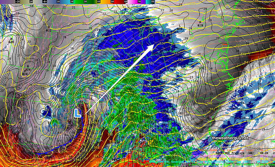
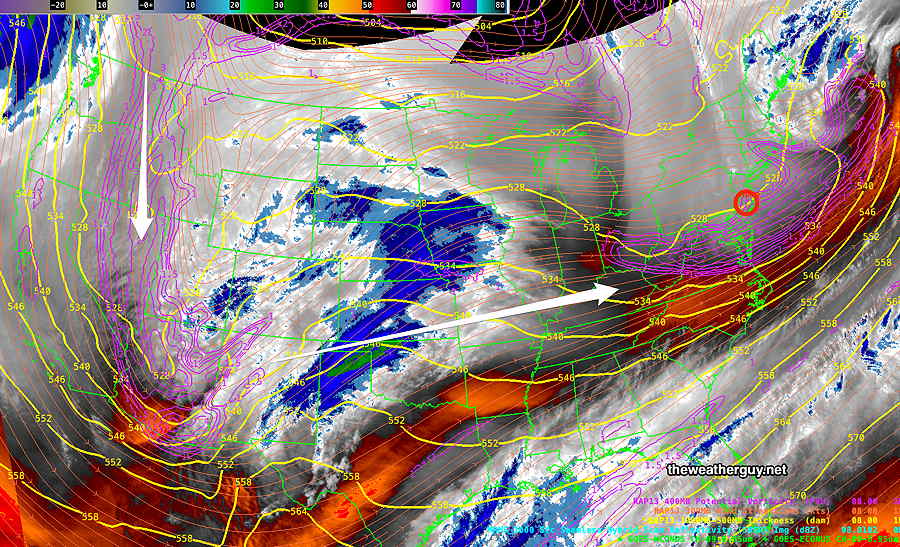
Posted Wednesday 01/10/24 @ 5:02 PM — Another disturbance dropping down in the northern jet stream flow will combine with a southern jet stream disturbance, creating yet another similar, (but not as powerful) low pressure system—
Current (Wed afternoon) satellite water vapor image with superimposed RAP model 500-1000 mb thickness lines (yellow), Mean Sea Level Pressure isobars (black contours) potential vorticity (fine violet contours) with superimposed MRMS RADAR. A strong disturbance (violet contours) in the northern jet dropping down along the Pacific coast will combine with the southern jet flow, spawning yet another low pressure system. (Click on image for a larger view.)
The NAEFS model’s forecast for 1 PM Saturday shows the combined jet stream and an enhanced area of high speed winds called a jet streak—
01-10-24 12z NAEFS model jet stream wind level (250 mb) forecast for Saturday at 1 PM. White area is >185 mph winds aloft.
This will be another night-time moderately heavy rain event.
Here’s the storm as forecast by the today’s ECMWF at 1 AM Saturday—
01-10-24 12 z ECMWF forecast for 1 AM Saturday morning. Another night-time heavy rain event. (Click on image for a larger view.)
Rainfall will be moderately heavy, not as heavy as Tuesday night’s storm, but saturated ground conditions will make be problematic. Wind gusts again will be high around midnight, in the 40-50 mph range!
Here’s today’s GFS forecast total precip—
01-10-24 12z GFS forecast total rainfall expected by noon Saturday. (Click on image for a larger view.)
It looks like the rain will begin after 6 PM Friday, earlier far western suburbs. Faster moving, it will end around daybreak Saturday with some clearing.
Stay tuned for updates.
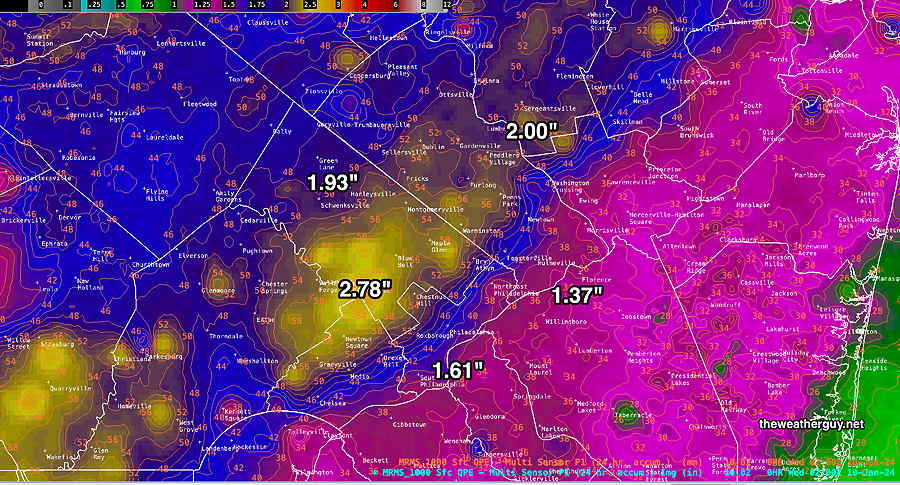
Wed 8:32 AM —Forecast Review —That was an impressive storm and the rainfall and wind forecasts were spot on.
Here’s the MRMS based final summary of the total rainfall we received with this storm —
MRMS combined rain gauge & radar-based measurement of rainfall received. Color shading is in inches. Line contour numbers are in mm (25.4 mm= 1 inch) (Click on image for a larger view.)
Just to note, the storm moved as had been expected and exited about an hour or two sooner than had been forecast.
For those of you who might want to follow the river flooding, the USGS (Unites States Geological Survey) maintains river gauges and posts live, real-time data on their web site . For the Perkiomen Creek-
I’ll be posting about the next rain storm late Friday and the cold outbreak to affect us next week later today.
Height of the Storm
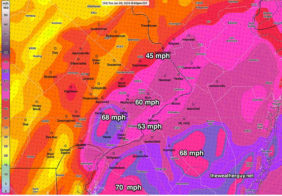
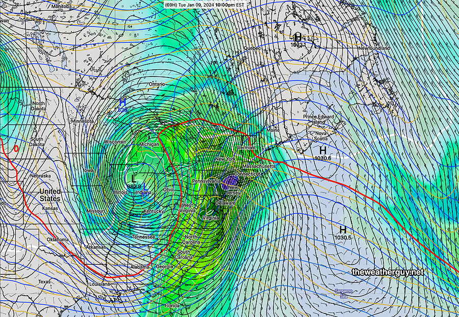
Posted Tuesday 01/09/24 @ 9:26 PM — Hearing the wind outside our home, I had to run another RTMA download. Here’s the wind gusts measured/interpolated at 9 PM—
0200z RTMA (9 PM EST) actual wind gusts measured/interpolated. (Click on image for a larger view.)
Incredibly, the 01z HRRR has higher wind gusts for us at 10 PM!
MRMS combined rain gauge & radar-based measurement of rainfall received through 9 PM. Color shading is in inches. Line contour numbers are in mm (25.4 mm= 1 inch) (Click on image for a larger view.)
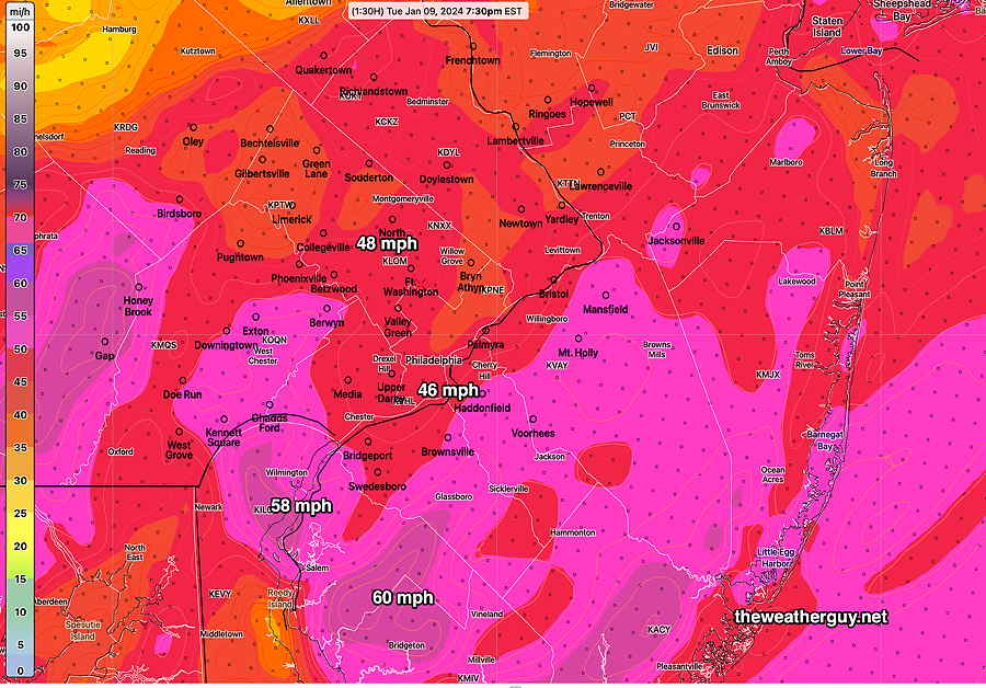
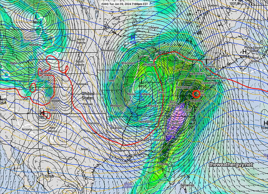
Posted Tuesday 01/09/24 @ 7:56 PM — We’re approaching the height of the storm. Here’s actual measured and extrapolated wind gusts measured at 7:30 PM tonight—
RTMA 7:30 PM (Click on image for a larger view.)
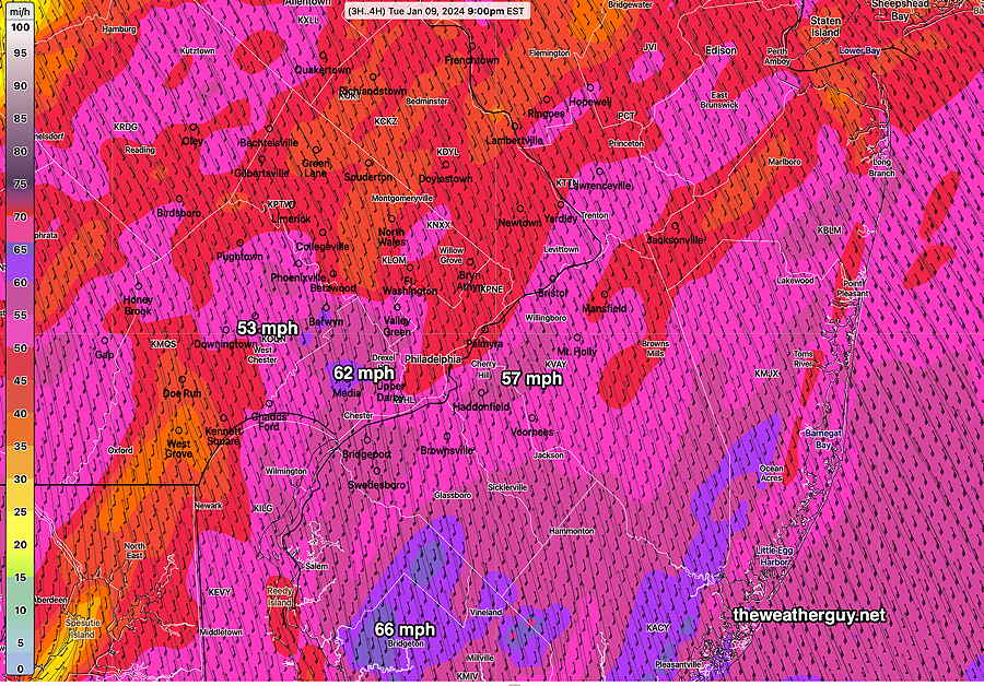
Here’s what the latest hourly HRRR model is forecasting for 9 PM—
01-09-24 23z HRRR wind gust forecast for 9 PM. (Click on image for a larger view.)
Heaviest Rain and Wind
Posted Tuesday 01/09/24 @ 4:11 PM — The heaviest rain and the highest winds will be this evening through about 1 AM.
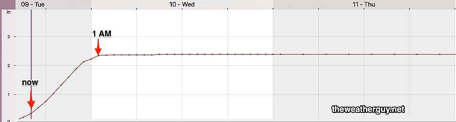
The rain should increase in intensity by 5 PM and remain quite heavy. An additional 2.2 inches + is possible, bringing the totals to 3 + inches in many areas.
18z NBM model rainfall. “now” is 4 PM. Steep slope shows 2.3 inches in (Blue Bell) over a 12 hour period! (Click on image for a larger view.)
The big concern is the wind and wind gusts, expected to peak between 10 PM and midnight in the immediate Philadelphia area. Here is the latest NBM model wind gust forecast for 10 PM—
01-09-24 18z NBM model blend wind gust forecast with standard deviations at 10 PM. (Click on image for a larger view.)
The NBM , as an average of numerous models, tends to be conservative with its wind forecasts. The latest NAM and NAM-NEST (not shown) have well over 65 mph gusts for a large portion of the area.
Tuesday Storm Update
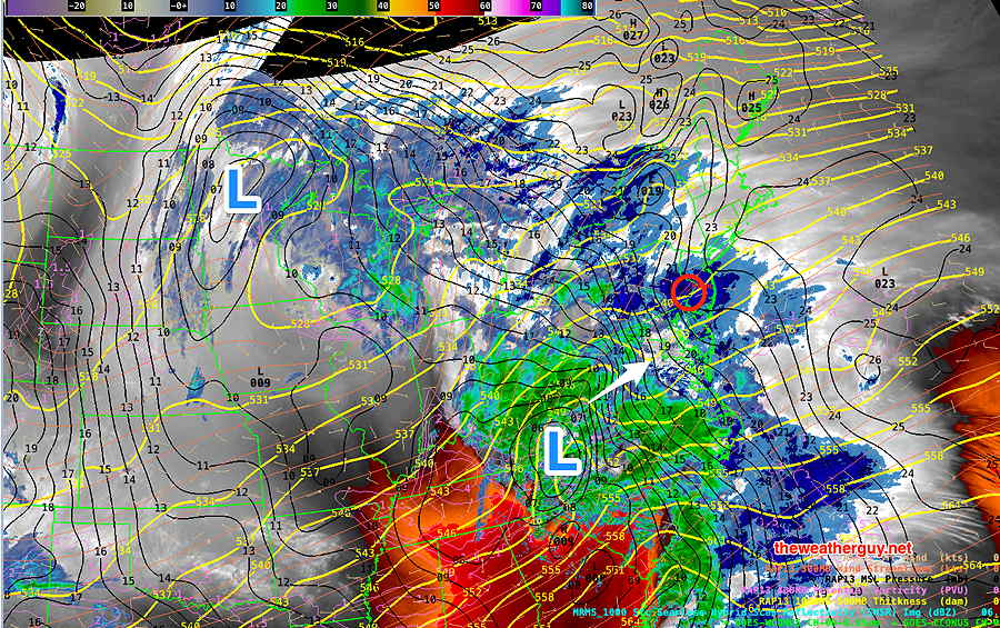
Posted Tuesday 01/09/24 @ 11:36 AM — Here’s the current water vapor image of the storm at 11:30 AM—
Current satellite water vapor image with superimposed RAP model 500-1000 mb thickness lines (yellow), Mean Sea Level Pressure isobars (black contours) potential vorticity (fine violet contours) with superimposed MRMS RADAR. (Click on image for a larger view.)
This morning’s models continue with a basically similar forecast. Each model varies somewhat with rain totals and the areal placement of the heaviest rain bands. Here’s this morning’s latest HREF model. (The HREF, being an ensemble model combines various higher resolution models into a statistical mean.)
01-09-24 12z HREF accumulated rainfall by 3 AM Wednesday. (Click on image for a larger view.)
The latest Canadian HRDPS is very similar. (The latest GFS, ECMWF and German ICON models have trended towards the heaviest rain in Northern NJ and NYC, but still crank out over 2 inches of rain in our immediate area.)
We’ve had several storms over the past month that threatened heavier rainfall. The issues with this storm:
• HIGH WINDS and WIND GUSTS around 50-60+ mph. • Saturated ground conditions, existing snow cover north and high river levels at the start. River Flooding appears likely. Flooding often occurs towards the end of the storm and in the hours afterwards.
Highest winds increasing in the evening and especially towards midnight, ahead of the cold front passage about 1 AM or so.
Tuesday Storm Update
Posted Monday 01/08/24 @ 10:43 PM — Tonight’s high resolution models continue with same forecast, but there will be bands of rainfall of over 3 inches. Wind gusts continue to be forecast in the 50-60 mph range in the period between 9 PM and midnight Tuesday evening. The leading edge of the rain moves in between 8 AM and 11AM.
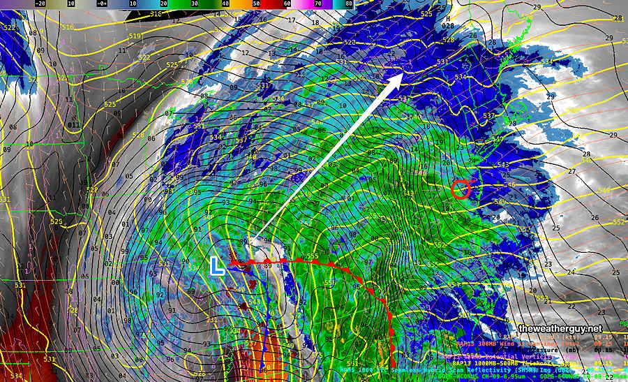
Posted Monday 01/08/24 @ 5:49 PM — A deep low pressure system and associated sharp cold front will affect our weather on Tuesday into early Wednesday with heavy rain, high winds and likely stream and river flooding.
Current satellite water vapor image at 5 :30 PM Monday with superimposed RAP model 500-1000 mb thickness lines (yellow), Mean Sea Level Pressure isobars (black contours) potential vorticity (fine violet contours) with superimposed MRMS RADAR.
The latest NBM accumulated precipitation forecast is for a generalized 2 to 3 inches of rain, beginning with light spotty showers as early as 9-11 AM (earlier in Chester and Delaware counties) with increasingly heavy rain into the evening and around midnight—
01-08-24 18z NBM accumulated rainfall through 1AM Wednesday. (Click on image for a larger view.)
Of concern is the increasing wind velocity and gusts expected with this deep low. Gusts over 50 mph and overall sustained winds of 30 mph will be likely towards midnight Tuesday.
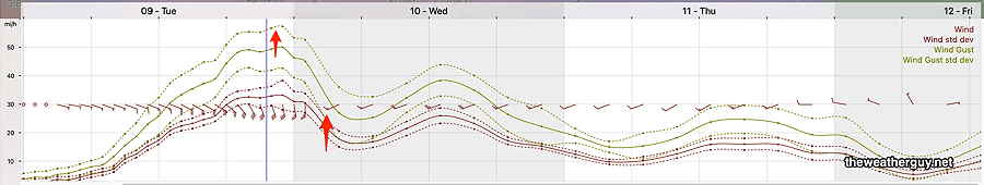
NBM wind and wind gust meteogram for Blue Bell PA. High winds and gusts towards midnight. The front comes through with an abrupt change in wind direction at about 2 AM Wednesday (second red arrow) (Click on image for a larger view.)
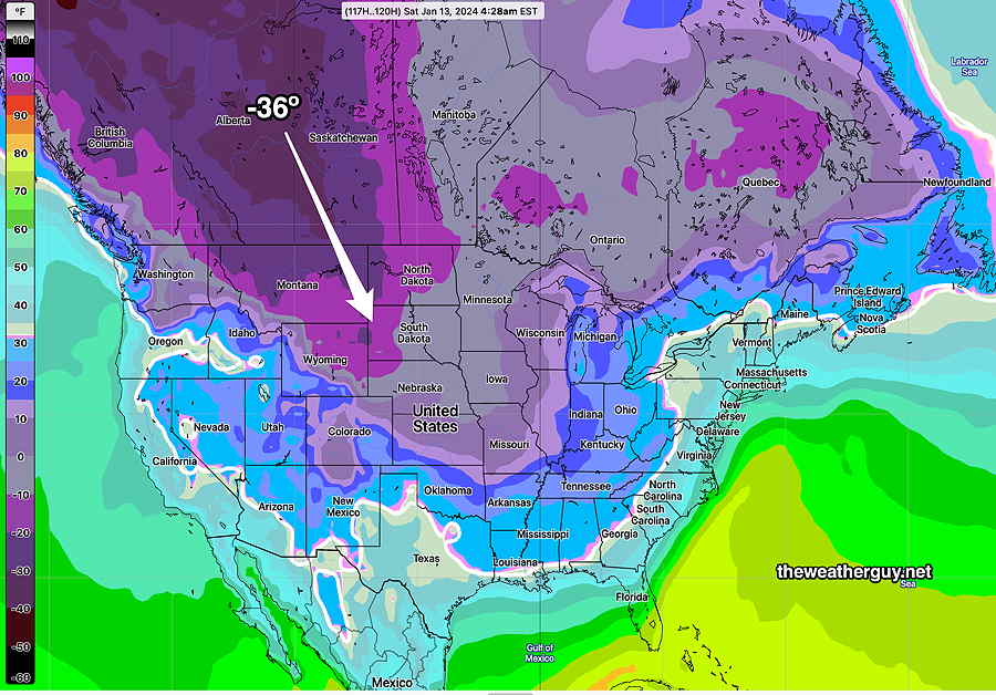
Another rainstorm is expected late Friday afternoon into Saturday morning bringing yet another 2 inches or rain. Following this storm, deep cold air is poised to move into the US—
01-08-24 12z NAEFS temperatures Saturday morning. Deep cold air mass in Alberta Canada is poised to descend into the US. (Click on image for a larger view.)
Tuesday Rain Storm Update
Posted Monday 01/08/24 @ 8:23 AM — The deep low pressure system looks to be moving in somewhat earlier than previously forecast. The rain moves in about 9-11 AM from the southwest, somewhat earlier in Chester and Delaware counties.
I know the models often predict wind gusts that seem to be in excess of those actually seen, but the wind gust model forecasts with this storm appear unusually impressive, with several models showing wind gusts anywhere from 50- 60 mph gusts and higher at the shore. These will occur Tuesday evening
01-08-24 06z GFS winds and gusts wind meteogram for Blue Bell, PA Also notice the wind shift about 1-2 AM indicating the cold front passage. (Click on image for a larger view.)
Rainfall is expected to be 2-3 inches in our area. With snow melt occurring due to warm winds bringing near 60º temperatures Tuesday evening, river flooding is looking increasingly likely.
Previously Posted Sun 8:48 PM —
A storm system near Arizona/Colorado will move northeast to the Great Lakes and rain from this system will move in Tuesday afternoon ahead of a cold front Wednesday.
Current satellite water vapor image (Sunday evening) with superimposed RAP model 500-1000 mb thickness lines (yellow), jet level wind streamlines (orange contour-arrows) potential vorticity (fine violet contours). This system will bring rain to our area Tuesday into Tuesday night. (Click on image for a larger view.)
Rain associated with this system will move in on Tuesday, likely in the early afternoon, and will become heavy Tuesday evening as temperatures rise to almost 60º. The rainfall is expected to be heavy (about 2″) but recent trends have reduced it from the 3″ previously forecast. Some river flooding is possible. High winds will be an issue.
01-07-24 18z NAEFS forecast for Tuesday at 7 PM Heavy rain expected here, but the heaviest rain now is forecast to be south and north of the Philadelphia area. A cold front moves through Wednesday. (Click on image for a larger view.)
But a quick look at tomorrow, Monday— mostly sunny, windy in the morning, diminishing winds in the afternoon. High in the low 40s.
Incredibly, another heavy rain event this coming Saturday.
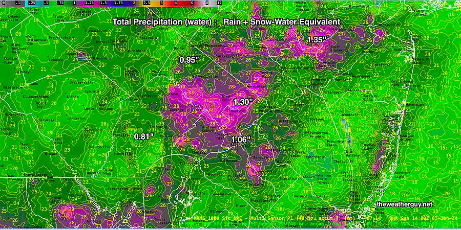
Posted Sunday 01/07 @ 10:11 AM —How much precipitation (water) did we receive (combined rainfall plus snow water equivalent)?
MRMS combined rain gauge & radar-based measurement of rainfall received. Color shading is in inches. Line contour numbers are in mm (25.4 mm= 1 inch) (Click on image for a larger view.)
With recent heavy rains and this recent past rainfall/snowfall, the concern exists for flooding with Tuesday night’s upcoming rain storm.
Sunday Forecast Update
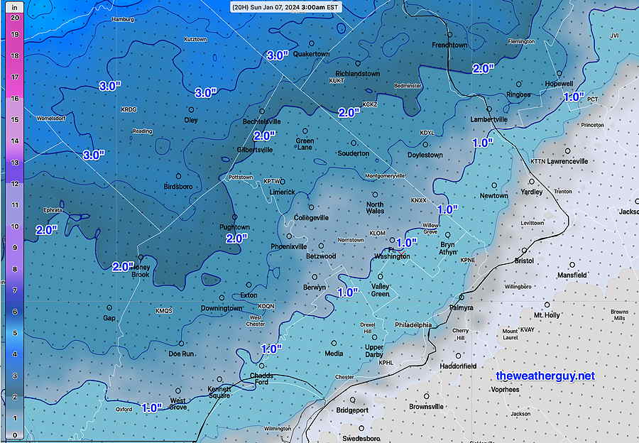
Posted Sunday 01/07 @ 9:42 AM — Colder air has moved in aloft and some of the the precip is changing to snow flurries this morning. No further accumulation is expected.
There was a wide range of snow totals, fairly well-predicted by the model forecasts. The “official” snow totals for our region can be found here.
The storm is departing and clouds are expected to linger until early to mid afternoon. (In NJ, for the Eagles game, it will be cloudy with some light spotty rain and or snow showers possible.)
We should see some clearing skies here about 2-4 PM. High temps about 40-42º.
A major rain storm is forecast for Tuesday into Tuesday night with temperatures approaching 60º. With recent heavy rains and areas of snowfall, flooding is appearing quite likely.
NAEFS for Tuesday night—
01-07-24 06z NAEFS forecast for Tuesday at 10 PM. Very heavy rain (3 inches+) expected for our entire area. (Click on image for a larger view.)
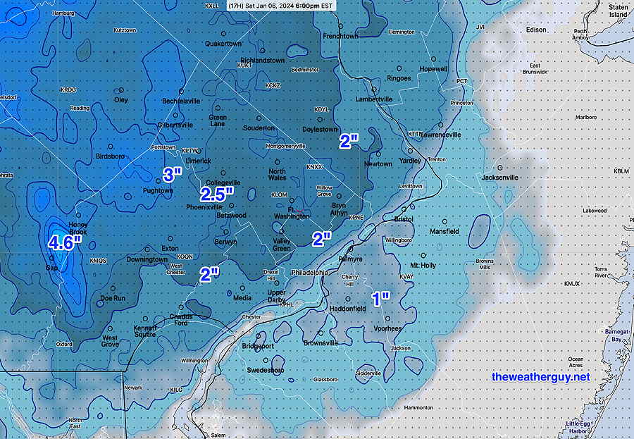
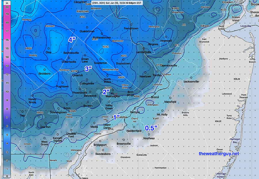
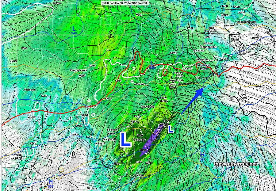
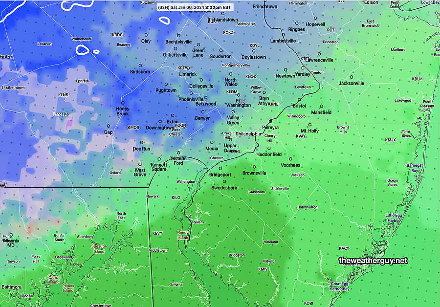
Posted Saturday 01/06 @ 2:21 PM — Heavier snow and a changeover to heavier rain has begun to move into our area. Still heavier rain is poised to move in—
MRMS Precipitation RATE with blackcontourindicating edge of Precipitation Type. The rain-snow line is just southeast of the city at 1:42 PM (Click on image for a larger view.)
There hasn’t been any significant change in the forecast snow amounts from this morning’s update. FYI, this morning’s HRDPS model joined the NBM with similar snow amounts.
I was hoping that the new, still-experimental RRFS model would be available for this storm, but they’ve been updating the model this week and it was not being run. To my delight, the NOAA Model Development Group ran it this morning. Here’s the RRFS snow forecast—
01-06-24 12z Experimental RRFS model under development. Snow forecast for today. (Click on image for a larger view.)
Saturday Forecast Update
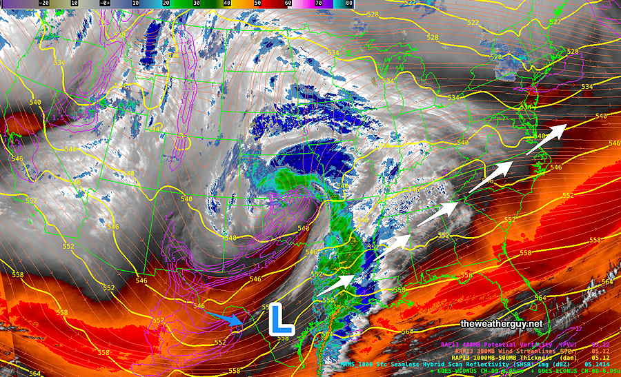
Posted Saturday 01/06 @ 9:13 AM — The system is approaching as forecast—
Current satellite water vapor image (~ 9 AM) with superimposed RAP model 500-1000 mb thickness lines (yellow), Mean Sea Level Pressure isobars (black contours) potential vorticity (fine violet contours) with superimposed MRMS RADAR.
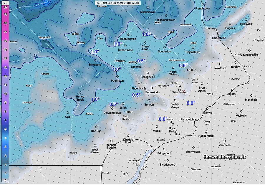
The latest NBM (12z) just became available and I wanted to post it. It shows a slight increase in the snow totals from last night’s run and greater similarity to last night’s NAM—
01-06-24 12z NBM snow totals (Click on image for a larger view.)
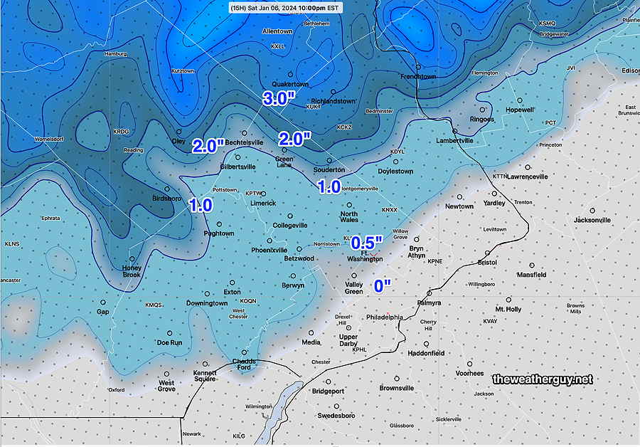
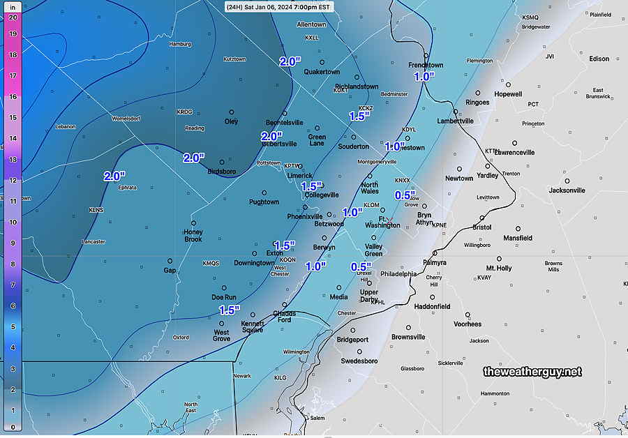
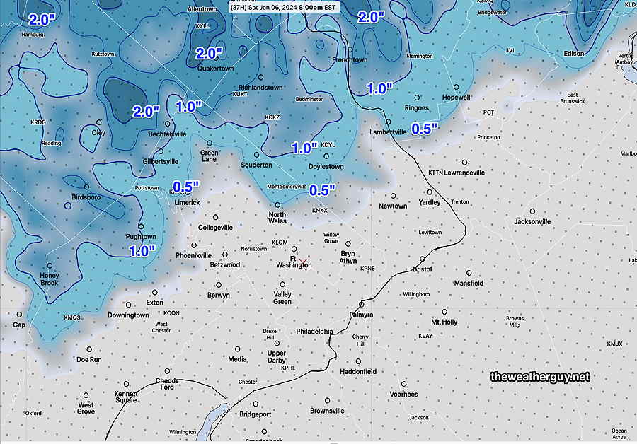
I’m going with the NBM forecast snow totals above, but I do want to post the latest Canadian HRDPS, which still is forecasting higher totals—
01-06-24 06z HRDPS forecast snow totals at 6 PM today. The HRDPS has been very good in situations where there’s snow to rain changeovers. I guess we’ll see. (Click on image for a larger view.)
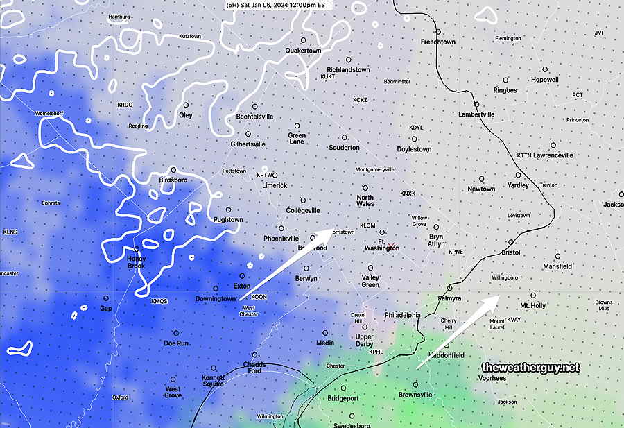
Snow or rain, depending on your location is expected to start around noon to 1 PM, earlier southwest —
01-06-24 12z NBM Precipitation type/probability. Blue is snow green is rain. The transition line is apparent as it moves in. (Click on image for a larger view.)
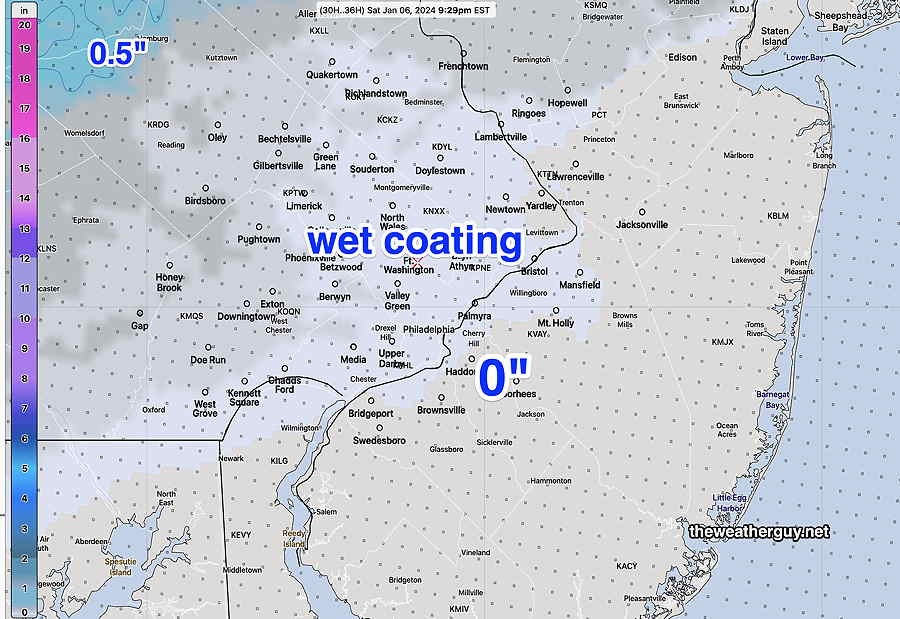
The any snow in the immediate area transitions to all rain 4 PM to 8 PM from southwest to northeast. Tapers to non- accumulating snow flurries and sprinkles Sunday morning
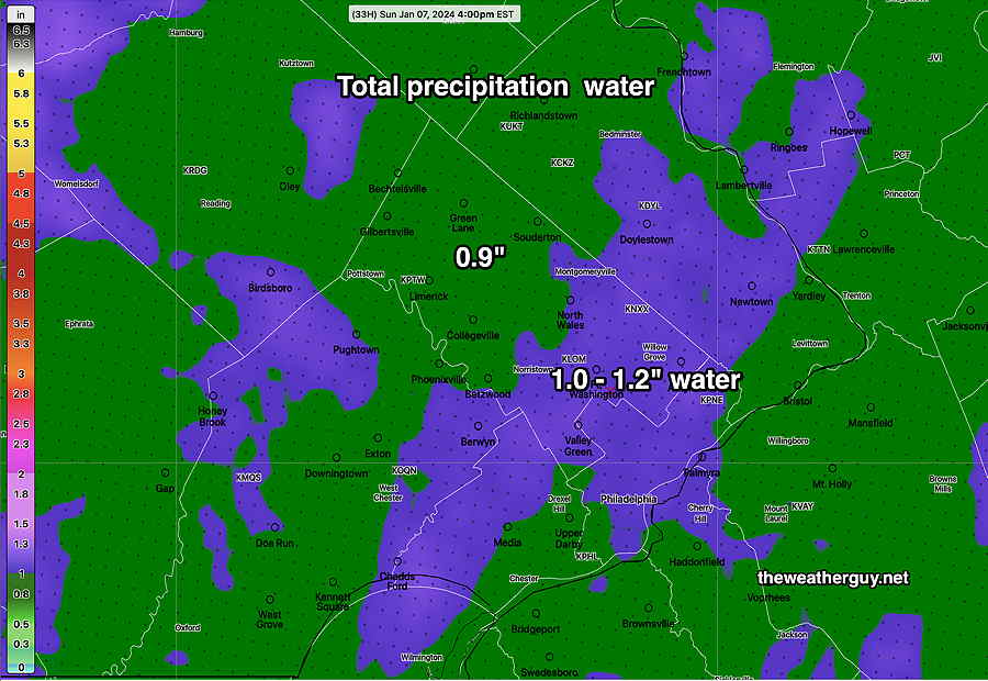
Total Rainfall and combined “snow-water equivalent” near 1 inch or more—
NBM total rainfall +water equuivalent of fallen snow (Click on image for a larger view.)
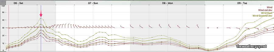
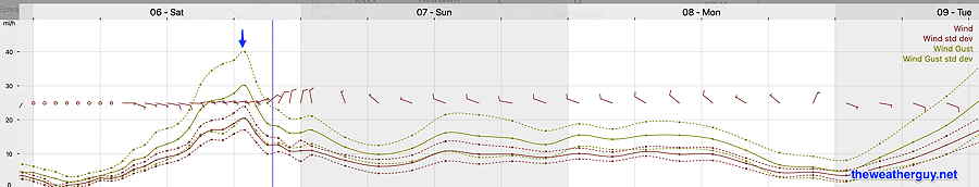
Winds increase Saturday evening—
Updates later this afternoon, between 5 and 6 PM.
Winter Storm Update
Posted Friday 01/05 @ 10:09 PM — One more thing I’ve glossed over… we’re not going to be getting much snow, but the total precipitation will be over an inch of rain or combined snow water equivalent. So whatever snow we get will turn into a heavy rain event with wind gusts Saturday evening.
Posted Friday 01/05 @ 9:09 PM — Tonight’s HRRR continues with a minimal to non-snow event for us and I’m leaning towards that, since it’s backed up by the NBM —
01-06-24 00z HRRR snow totals. Contours are labeled with snow depths. (Click on image for a larger view.)
As pointed out in my earlier post, the Canadian HRDPS was showing somewhat more snow. With my long standing mantra, “Never Ignore the NAM”, I’m posting tonight’s NAM snow forecast for old time’s sake, which is somewhat similar to the HRDPS —
01-06-24 00z NAM Snow forecast through 7 PM Saturday. (Click on image for a larger view.)
Weekend Storm Update
I’ve already committed to a mostly rain event, starting as light snow and changing to rain avoiding accumulations in most areas.
Of interest is the Canadian HRDPS model which maintains a cold lower atmosphere longer as heavy precipitation moves in sooner. The HRDPS is forecasting heavier snow before a later changeover to rain around 5 PM.
Here’s the latest HRDPS snow accumulation max at 7 PM—
01-05-24 18z HRDPS snow totals (Click on image for a larger view.)
I’m just putting this out there because the HRDPS did very well with precipitation types last year. If we get more snow than the NBM and HRRR are forecasting, it won’t be a complete surprise. This is what makes this so interesting.
Posted Friday 01/05 @ 4:48 PM — The forecast continues to change in the direction of a much warmer, inland system for us with late coastal redevelopment off of NJ.
The latest NAM-NEST captures the newer track of the storm, which pushes warm air into our area—
01-05-24 NAM-NEST forecast for 7 PM Saturday has the main low moving up from the southwest over Maryland. The inland track brings even more warm air into the system for us. A secondary low forms off of the NJ coast. Heavy rain now seems likely for eastern NJ. Note that the surface freezing line is way to our north (white contour) and the 540 thickness line (red contour) to our north indicates a warmer atmosphere.
As a result, any snow that develops around noontime will quickly mix with and change to rain by late afternoon and early evening. Any accumulation Saturday afternoon will be reduced considerably by fairly heavy rain Saturday evening. Indeed, it looks like this storm is essentially a rain storm for us.
As the system moves through and the secondary low develops off the coast of NJ, expect some big wind gusts Saturday evening.
NBM winds/wind gusts peak early evening Saturday. (Click on image for a larger view.)
Here’s the latest model blend (NBM) snow totals, a significant change from previous forecasts—
I’m already keeping my eye on the next storm, a rain storm for us, for much of Tuesday.
Weekend Storm Outlook
Previously Posted Fri 10:01 AM —
The development of this approaching storm system has been forecast by the models for almost two weeks and its general evolution so far hasn’t had many surprises. Despite being in a favorable location for heavy snow in our region (in colder ‘normal’ past winters), the lack of deep cold this winter will result in a mixed bag of precipitation types, now mostly rain. The latest model trend is for much less (or no) snow accumulation (see below).
Friday morning, the storm is currently just off the coast of Texas—
The precipitation will reach our area, from southwest to northeast, about noon to 2 PM, somewhat earlier in western Chester county. It will begin as light snow/flurries but will increase in intensity and mix with rain as early 3 PM in many locations that start as snow.
01-05-24 12z NBM Precipitation type at 3 PM. Many locations are all rain or a mix except north and west of the city. (Click on image for a larger view.)
By 10 PM, most areas are just receiving rain with temps in the mid to upper 30s—
01-05-24 12z NBM precip type/ conditional probability at 10 PM. (Click on image for a larger view.)
A change back to some wet snow will occur as some cold air aloft mixes back in as the low pressure depart early morning Sunday.
01-05-24 12z NBM forecast 7 AM Sunday. Mostly light rain, some wet snow mixed in. Temps above freezing here. (Click on image for a larger view.)
Light sprinkles, spotty showers and snow flurries persist until early afternoon. The Eagles will have mostly dry conditions, temps around 37º, not too windy, at game start.
Total snow accumulation forecast continue to diminish to zero in many areas—
Latest 01-05-24 12z HRRR shows virtually no snow for much of the immediate PHL area. (Click on image for a larger view.)