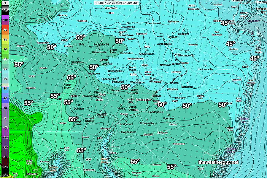
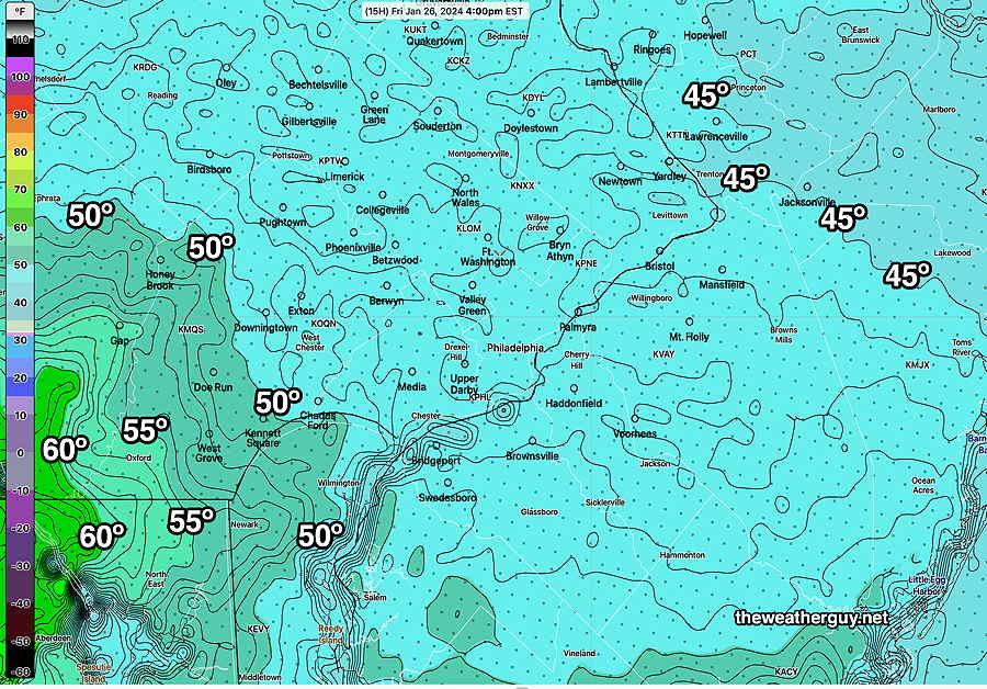
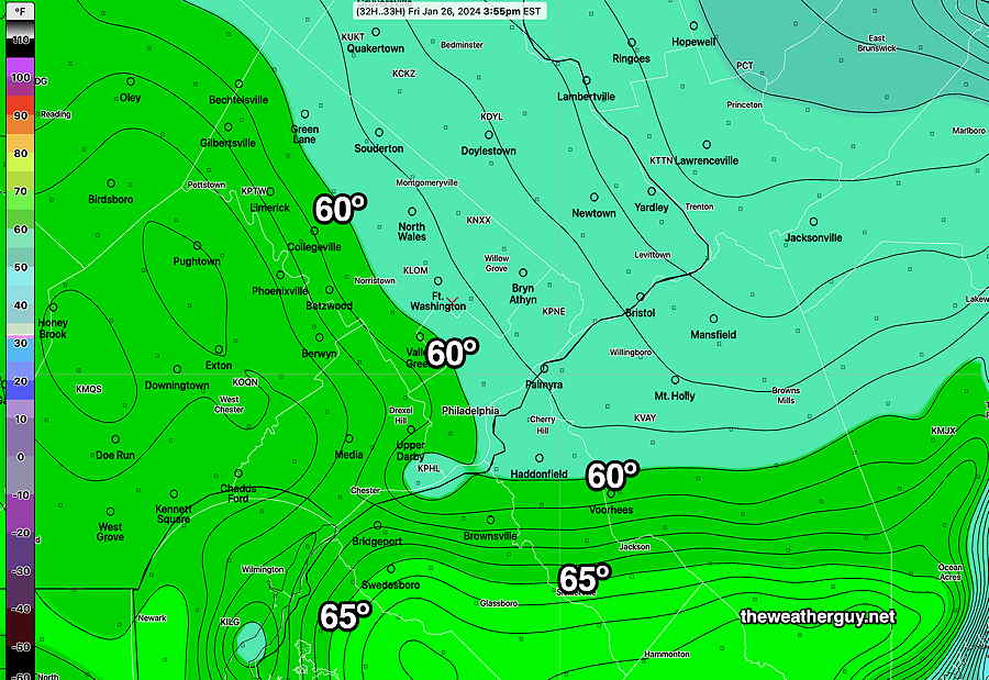
Fri 4:29 PM —Forecast Review — The high temperatures were closer to the NAM-NEST forecast, as was the cloud cover and drizzle mist. The warm front never made it through our area.
Here are the actual temperatures recorded by the RTMA—
RTMA (Real Time Mesoscale Analysis) at 3:15 PM, actual temperatures . Contours are 1º increments. (Click on image for a larger view.)
Friday Forecast Change
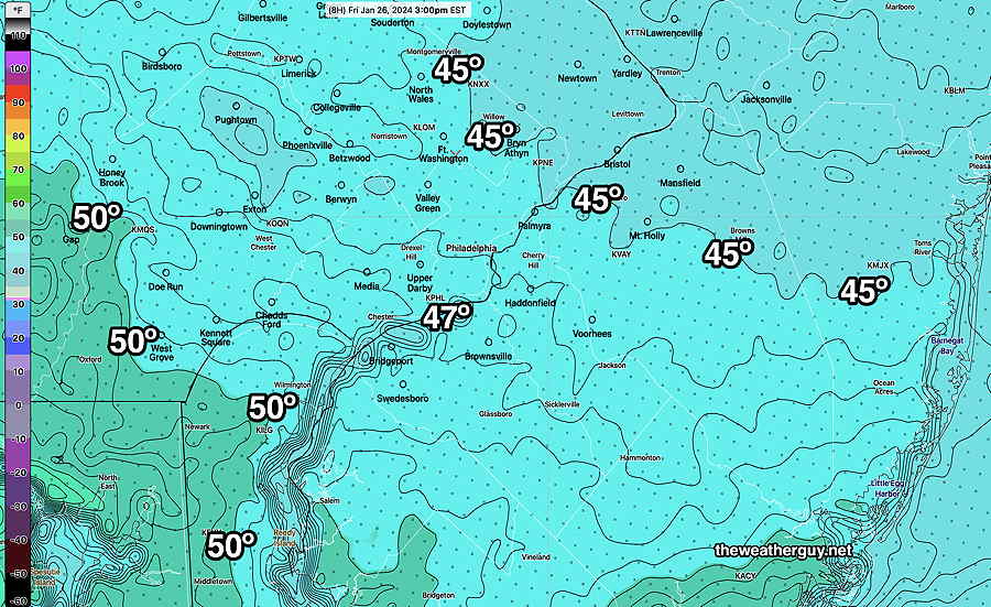
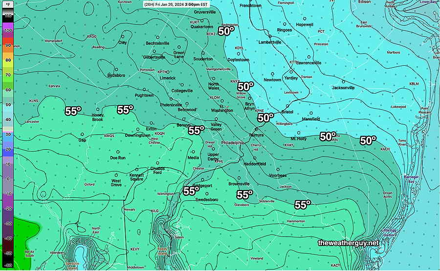
Posted Friday 01/26/24 @ 11:11 AM — It looks like the NAM-NEST forecast will be closer to reality, perhaps a bit too cold. Here’s the latest NAM-NEST (12z)
01-26-24 12z NAM_NEST high temperatures for Friday. The NAM-NEST has been the consistent colder temperature forecast. (Click on image for a larger view.)
If we’re going totally with the NAM-NEST model, instead of the clearing and sunshine around noontime (as forecast by the other models), the NAM-NEST keeps us cloudy all day! It even keeps the drizzle going in some areas through the afternoon. This is what happens when one “ignores the NAM”.
Posted Friday 01/26/24 @ 8:39 AM — A quick mobile update. Well, I just viewed this morning’s (12z) HRRR which just became available after tunneling into my weather data server. It is leaning towards a much cooler day with high temperatures in the low 50s. My guess is later runs of the NBM will show this trend too. Perhaps I should learn to follow my own mantra— “Never ignore the NAM”. (In this case, the NAM-NEST).
Friday’s Temperatures
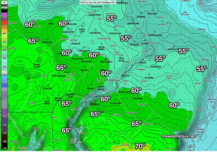
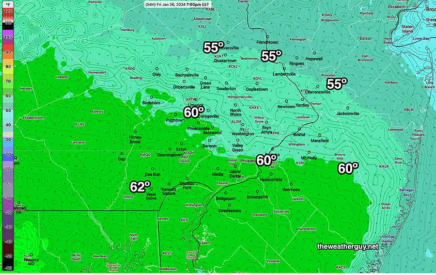
Posted Friday 01/26/24 @ 6:56 AM — The models have trended closer to the 60º+ promised earlier in the week. Here’s the latest NBM—
01-26-24 06z NBM high temps for Friday. (Click on image for a larger view.)
As mentioned, consistent with this forecast has been the HRRR. Also consistent (but often forecasts too warm in this location) is the Canadian HRDPS—
01-26-24 06z HRDPS high temps. (approx) (Click on image for a larger view.)
So I’m forced to go with the warmer NBM forecast. It’s designed to do the heavy lifting with these sort of forecasts. BUT…
Just food for thought is the NAM-NEST. It’s still maintaining much colder temperatures. I’ve seen it correct in these situations. If the warm forecast goes bust, we’ve ignored the NAM-NEST—
01-26-24 06z NAM-NEST. Much cooler temps than the other models. Could it be correct?? (Click on image for a larger view.)
So How Warm will it be Friday?
Posted Thursday 01/25/24 @ 5:03 PM — That’s a great question. The latest models have a ± 10 degree spread (sd=10º) which is as large as I’ve ever seen in a less than 24 hour forecast.
The latest (18z) GFS keeps us in the 50s as does the NBM and HREF forecast. The NAM-NEST is forecasting the upper 40s for us while the HRRR is consistently forecasting 65º. The HRRR is probably our most advanced model.
Here’s the latest HREF which combines and time lags several different models—
01-25-24 18z HREF forecast high temps for Friday. Contours are 1º intervals. In Philadelphia, there’s an uncertainty of ± 10 degrees, which is as large as it gets. (Click on image for a larger view.)
As much as I want it to be 65º on Friday, my experience whenever the NAM-NEST is so cold with warm front passages in winter, means the warm front doesn’t make it through. (It’s different in Spring and Summer, where the NEST can be too cold. )
I’m planning on biking on the Schuylkill Trail Friday whether it’s 48º or 65º. I just hope they’ve dealt with the mud!
Posted Thursday 01/25/24 @ 11:06 AM — I’ve waited to update to review this morning’s models. The forecast for Friday, which has been “up in the air” based on the large spread in model forecasts, has not clarified and it’s not clear that we break out into sunshine by mid to late morning with temperatures in the mid 60s, as forecast consistently by the HRRR!
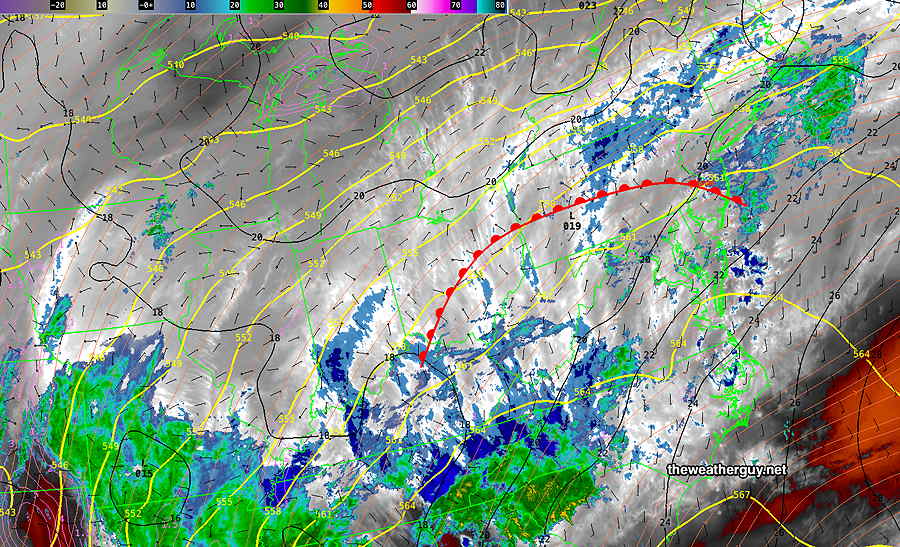
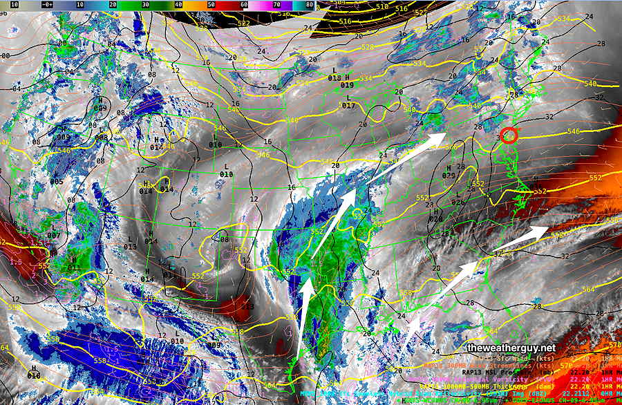
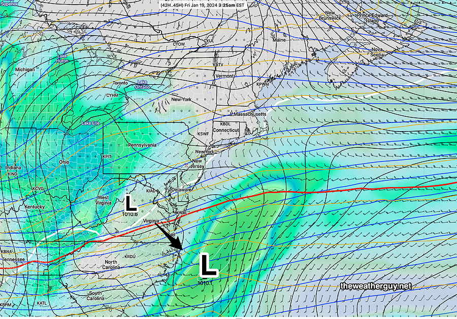
Basically, it’s not clear whether the warm front will move far enough north of our area on Friday. The warm front is somewhat stationary near us and waves of low pressure will move over us on Thursday into early Friday morning delivering an additional 0.75″ of rain. —
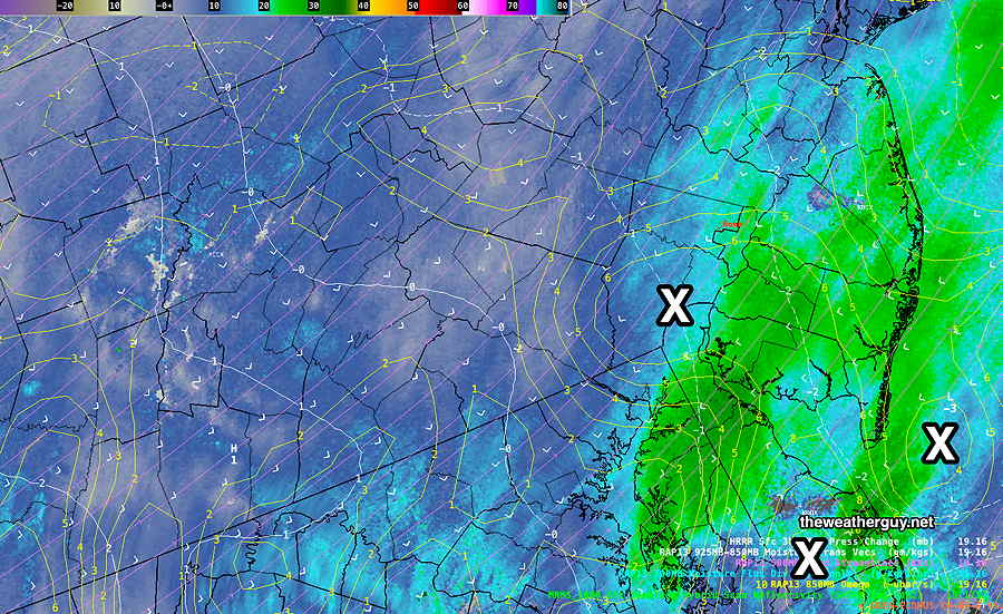
Current satellite water vapor image Thursday 11 AM with superimposed RAP model 500-1000 mb thickness lines (yellow), Mean Sea Level Pressure isobars (black contours) potential vorticity (fine violet contours) with superimposed MRMS RADAR. Warm front position drawn based on wind direction at the surface. (Click on image for a larger view.)
The model blend (NBM )still has us in considerable cloudiness into mid afternoon with a high in the mid 50s and the HREF, an ensemble model based on several models keeps us in the mid 50s with clouds not really breaking until 1-2 PM, earlier in western suburbs.
Here’s this morning’s 12z model blend (NBM) —
01-25-24 12z NBM high temp forecast for Friday. The trend has been downward, (Click on image for a larger view.)
In contrast, the latest Canadian RGEM (which does tend to run a bit too warm in our area) is closer to the much warmer HRRR —
01-25-24 12z Canadian RGEM (RDPS) (Click on image for a larger view.)
Winter warm front passages are notorious for slow northward movement in our area. I’ll keep an eye on it.
Posted Wednesday 01/24/24 @ 8:02 PM — The forecast for the next few days continues to be a challenge and it appears to have changed considerably from yesterday. As described over past posts, the high temperature as forecast by the model blend (NBM) has had huge standard deviations, indicating high spread in the model forecasts and much higher uncertainty in the overall forecast.
Wednesday certainly turned out bit more dismal than expected and if you liked today, you’ll like Thursday which promises to have much more rain, perhaps with a break in the action mid day.
Several things have changed with today’s model guidance—
• The gusty winds forecast around midnight are now only forecast by the GFS. The wind gust forecasts from the other models are not impressive. • The timing of each bolus of rain and each wave along the warm front varies. Some models have the rain ending around daybreak Friday with possible breaks of sun. Other models have rain lingering until at least noontime and remaining cloudy. • The much promised 60º+ temperatures on Friday are not a certainty and the forecast trend for temperatures stay in the 50s here. Essentially, the warm front may not make it north past Philadelphia. • The front will return as a weak cold front and temperatures on Saturday look to be lower than whatever we reach on Friday.
It’s a good thing all forecasts aren’t this challenging.
Here’s the model blend (NBM) high temperature forecast. Note that this temperature forecast is the average based on the many models that comprise the NBM.
Statistically, these highs temps are very uncertain with a standard deviation (think of it as “±” ) 7º. We could hit near 70º; we could stay in the 50s.
This afternoon’s 18z NBM shows highs that are somewhat lower than this morning’s forecast and with an even larger standard deviation. (Click on image for a larger view.)
Posted Wednesday 01/24/24 @ 8:24 AM — A warm front will move through tonight around midnight an very windy conditions will develop at that time as a very strong low level jet (about 3000 feet above) moves over us.
Before that time, I’ll have to retract my forecast of cloudy but “dry” conditions today, Wednesday, as some models are cranking out light drizzle or very spotty showers.
I keep hearing on the radio about highs of over 60º; That that will occur on Friday, not Thursday. We’ll only be in the mid 50s at best on Thursday, late afternoon.
The warm front clears our area on Friday and we’ll be in the low 60s by mid to late afternoon. (There’s still an unusually high “spread” in model forecast high temperatures of ± 5.5º, capturing high uncertainty in that high temperature; it could be higher, it could be lower.)
High temperatures on Friday—
01-24-24 06z NBM high temperatures for Friday (Click on image for a larger view.)
Posted Tuesday 01/23/24 @ 7:26 PM — We had more sunshine today (Tuesday) than had been forecast.
Wednesday does appear to be cloudy, but dry until the evening. There’s a large spread (higher than usual uncertainty) in the high temperatures forecast on Wednesday, with the GFS keeping us in the low 40s while the NBM and HRRR has us reaching 46º.
Around midnight Wednesday into Thursday morning, rain will move in with very GUSTY WINDS.
Much of Thursday will have periods light rain and temperatures are expected to reach the low 50s but still with a wide spread in the model forecast highs. (The GFS keeps us only in the mid 40s.)
Friday looks damp and wet early, then cloudy with temperatures in the low 60s!
Saturday looks cloudy but mild and dry. An easterly wind will keep us from being as warm as Friday.
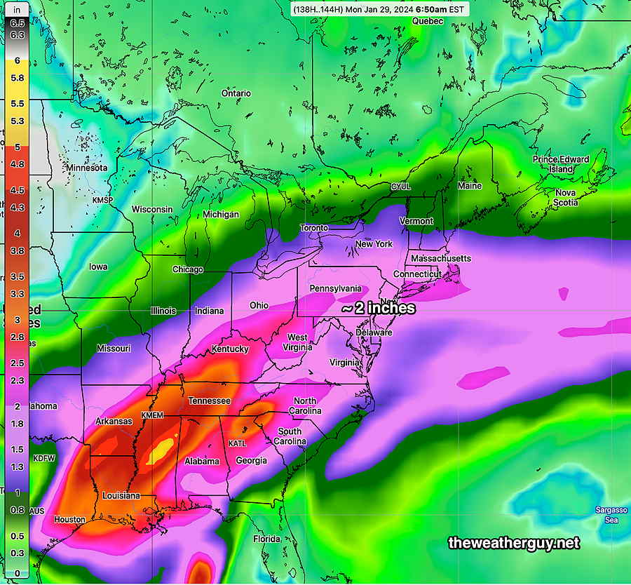
Between Wednesday and Monday morning, we will likely have received another 2 inches of rain—
Todays’ GEFS model’s accumulative rain through Monday morning. (Click on image for a larger view.)
Just wanted to mention that the large spread in the forecast high temperatures usually indicates large uncertainty in cloud cover and the forecast in general. I expect daily forecast specifics to change.
Posted Monday 01/22/24 @ 4:46 PM — The stream of moisture continues to take shape and poised to move in late Tuesday into Wednesday and especially Thursday into Friday—
Current satellite water vapor image (Monday afternoon) with superimposed RAP model 500-1000 mb thickness lines (yellow), Mean Sea Level Pressure isobars (black contours) potential vorticity (fine violet contours) with superimposed MRMS RADAR.
Plenty of clouds are expected Tuesday but rain is expected to stay to our north.
Light rain develops before daybreak Wednesday, but the heavy rain probably won’t move in until Thursday into Friday. Another round of rain, possibly late Saturday into Sunday. I expect the exact timing of each system to change.
Over this time period, we may get another 2 inches of rain total!
So we’ll be getting milder weather through Saturday, then a chill down early next week.
The beginning of February may be quite mild.
Previously Posted Sun 9:39 PM —
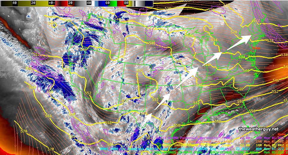
This week will feature a transition from a very cold upper level trough to a building upper level ridge with moisture from a southwesterly flow from the Gulf of Mexico. Here’s the current water vapor image showing the developing moisture conveyor belt from the Gulf—
Water Vapor image with RAP model thickness contours and jet stream wind streamlines. The disturbance developing in Texas will bring a continuous stream of moisture from late Tuesday possibly through Saturday or Sunday. (Click on image for larger view.)
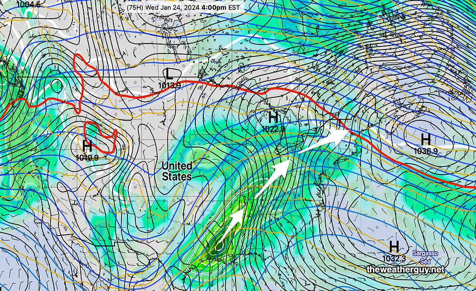
The NAEFS forecast for Wednesday captures the developing flow of moisture and low pressure systems that will move in from the southwest—
NAEFS forecast for Wednesday at 4 PM shows the developing moisture stream from our southwest. (Click on image for larger view.)
Monday will be the nicest day (sunshine-wise) but also still the coldest. There may be a period of cloudiness during the day Monday as some moisture from the system moves off to our northwest.
Gradual moderating temperatures through the week with rain expected by late Tuesday. Temperatures by Friday may be near 60º but it might be quite wet. An inch or more of rain is possible by Friday. Frozen ground, existing snow cover, saturated frozen ground may result in some flooding, although the exact level of a flooding threat isn’t known just yet.
Posted Sun, 01/21/24 @ 3:38 PM— I’ve updated this past Friday’s snowforecastreviewwithsome new information and insights.
Previously Posted Fri 6:01 PM —
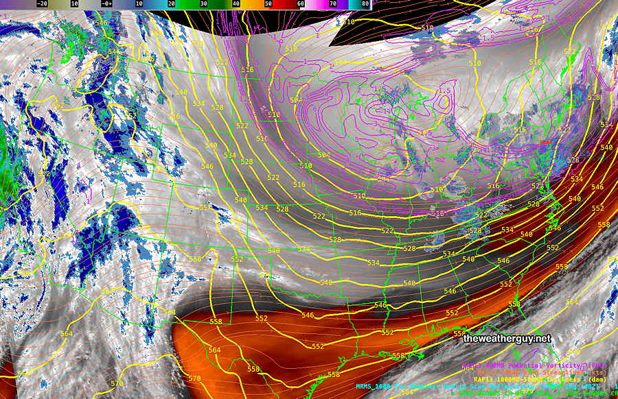
The low pressure system that brought us the snow Friday will be followed by a very cold high pressure system, and the upper aircyclonic flow and pressure gradient will result in cloudiness on Saturday and windy conditions both Saturday and Sunday.
Current satellite water vapor image with superimposed RAP model 500-1000 mb thickness lines (yellow), jet level wind streamlines (orange contour-arrows) potential vorticity (fine violet contours) and superimposed MRMS radar. The upper low over the Great Lakes will drift eastward. (Click on image for a larger view.)
Saturday
Some sun in the morning, followed by mostly cloudy skies late morning into the mid afternoon. Clouds should diminish late afternoon. WINDY and extremely cold.
High temperature 23º ( NBM model— location Blue Bell, PA) High temperature 24º ( NBM model— location Philadelphia, PA) above average confidence.
Sunday
Sunny and continued windy in the morning, less windy in the afternoon. Still very cold, but not as cold as Saturday.
High temperature 29º ( NBM model— location Blue Bell, PA) High temperature 30º ( NBM model— location Philadelphia, PA)
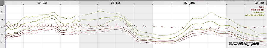
Winds
NBM wind meteogram for location Blue Bell, PA (Click on image for a larger view.)
Extended Outlook
I don’t see any more snow through the end of January. Moderating temperatures later this coming week. There may be a big warm up later in the month into February.
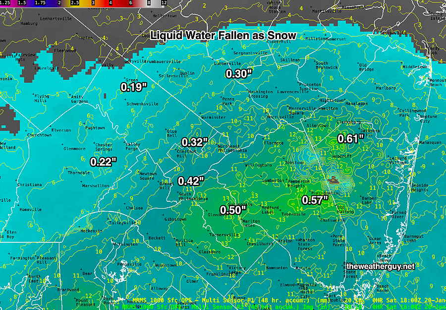
Sun 01/21/24 @ 3:13 PM —Forecast Review — I’ve done some additional thinking and research regarding this storm, to answer the question, ‘why were the forecast snow totals too low’?
My first inclination was that the snow water ratio was higher than expected. But I decided to look at the actual water values that fell. Here’s the MRMS liquid water totals for the storm —
MRMS 48 hour precipitation accumulation summary (water values) shows that the actual water that fell as snow was much higher than any of the models had forecast. (Click on image for larger view.)
In most areas the actual water that fell as snow was at least 0.1 – 0.4 inches higher than the models had forecast. Even at a snow-liquid ratio of 11, the snow totals forecast were going to be at 1.5 to over 4 inches too low.
Many models had forecast as little as 0.23″ water (GFS ECMWF) and 0.30″ water (NAM, NBM). Since all model snow forecasts start with the actual water expected to fall, the model snow accumuation forecast was destined to come up short.
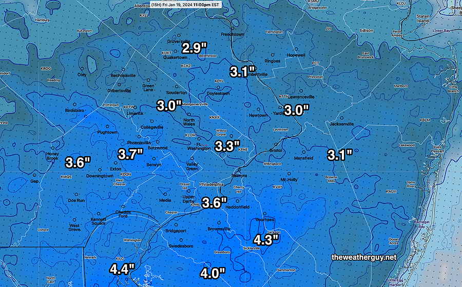
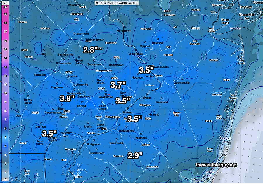
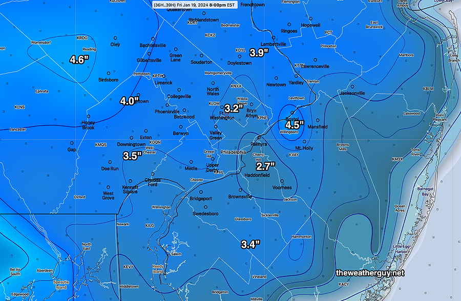
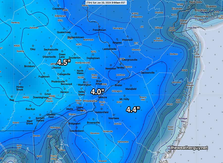
Posted Friday 01/19/24 @ 2:57 PM — The snow is beginning to taper off around here and I’ll be getting out the snow shovel when it ends about 4 PM to 7 PM.
Fri 2:57 PM —Forecast Review — I’ve read several NWS snow total reports and the final final totals won’t appear for a few hours.
In my neck of the woods, we’ve had 4.5″ of snow so far at 2:55 PM and my guess is that the totals in the immediate PHL area will be in the 4-5″ range with higher amounts close to 6″ south into southern Delaware County and South Jersey.
I think the NWS did a fine job with their forecast of 3-6″and my forecast of 3.3″ or so underestimated the snowfall. Influenced by the lower totals predicted by the GFS and Canadian CMC- HRPS, I ended up “ignoring the NAM”.
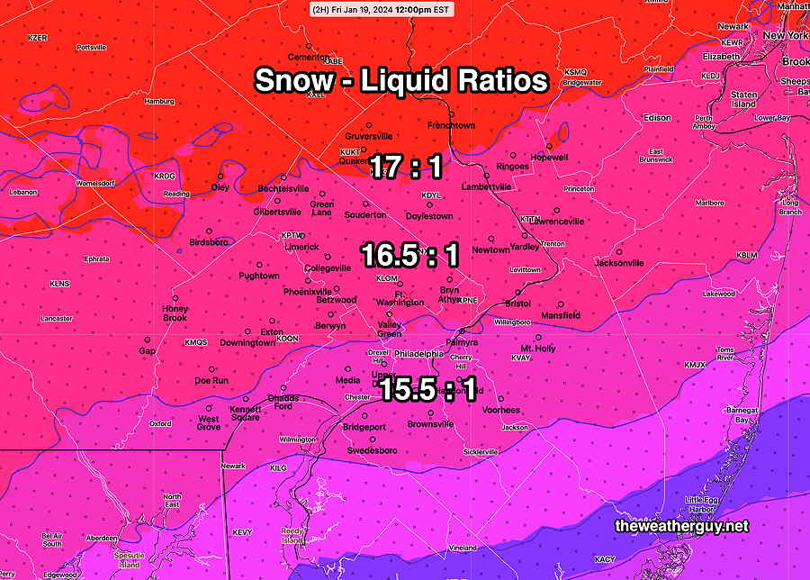
That said, I still would have come in low on the snow totals had I used the NAM precip amounts. The snow:water ratio that generally works here is 10:1 or 11:1. Because of the cold temperatures, the snow:water ratio during this storm was 15:1, 16:1 and higher.
I did not know that the NBM has a new parameter, SNOWLR (snow-liquid ratio). I’ve always wanted that number for forecasts, and the next storm, I’ll use it.
This was the SNOWLR at noon today, as calculated by the NBM—
With the ratio as high as it was, the snowfall was about 50% more than I had (and would have) forecast, even if I had used the NAM.
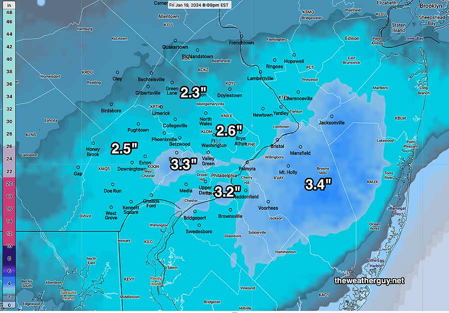
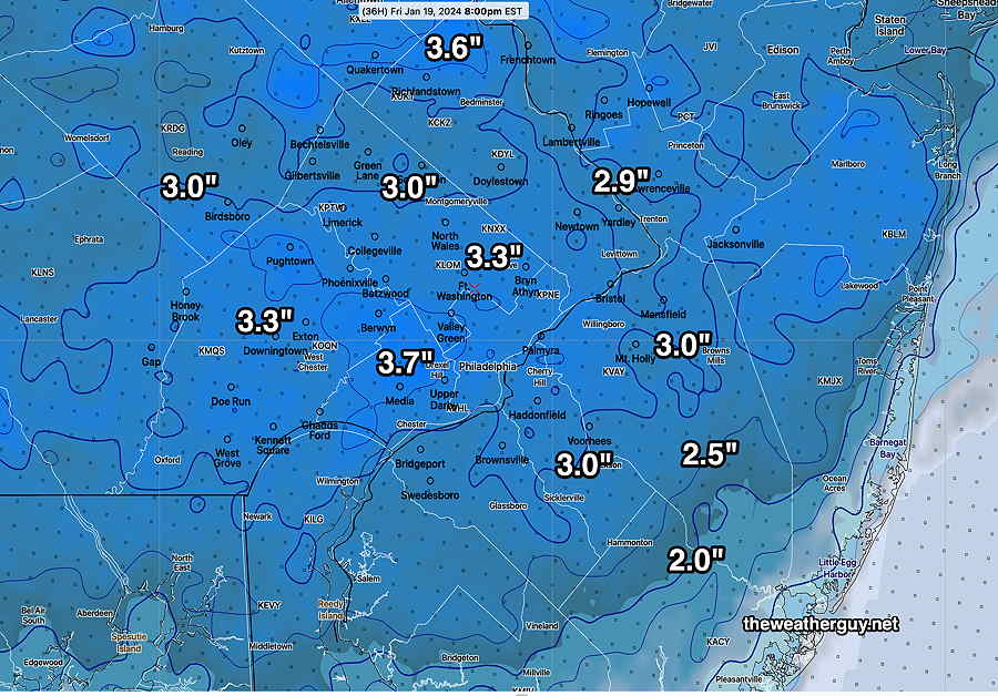
Friday Snow Update
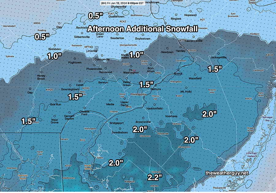
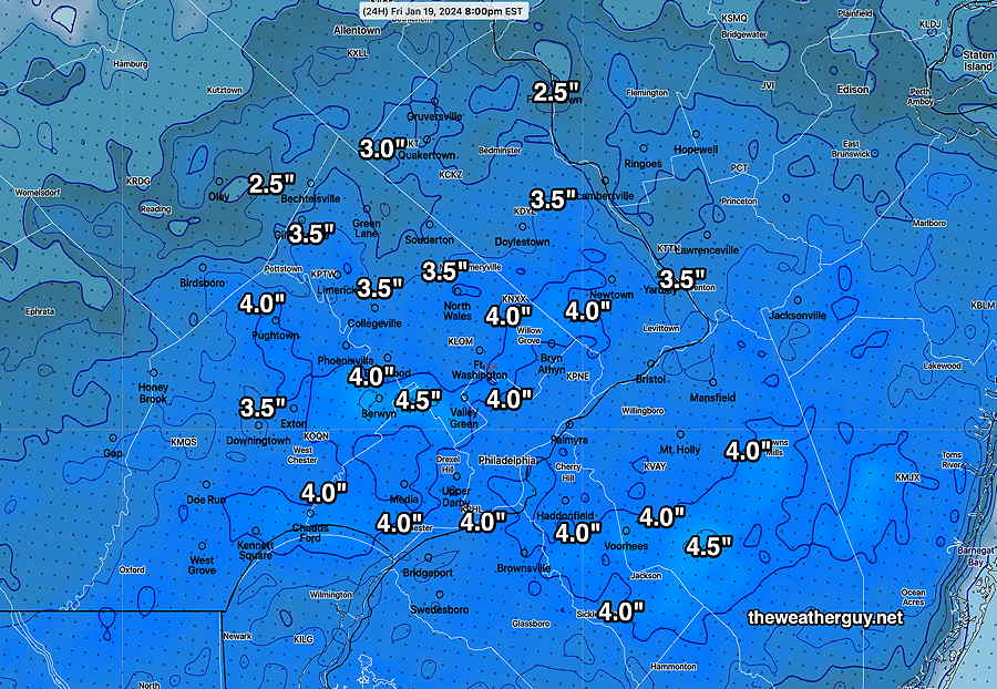
Posted Friday 01/19/24 @ 12:42 PM — It appears that we will have an additional 1-2 inches of snow from noon to about 4-7 PM when it tapers off and ends.
Additional snow forecast from noon onward—
NBM 17z additional snowfall from noon onward. 50 percentile forecast (Click on image for a larger view.)
Posted Friday 01/19/24 @ 12:30 PM — I wish I could take back that last blog entry below. What looked like an area of precipitation moving off to the east was actually not moving at much at all. In fact, in the short term, it’s blossoming.
A persistent area of vertical motion (called Omega) has developed right over our area and South Jersey which will keep the snow falling into the early afternoon. We already have 3.25″ of snow in our neck of the woods.
Water Vapor with MRMS radar and superimposed RAP model Omega. The area of upward vertical motion is showing persistence in our neck of the woods. (Click on image for a larger view.)
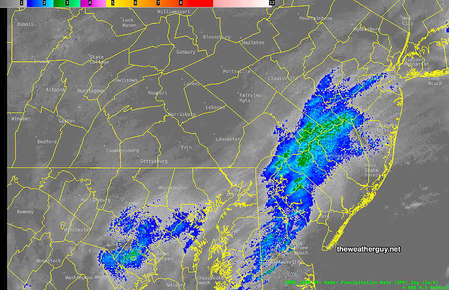
Posted Friday 01/19/24 @ 11:01 AM — I think we’re beginning to see why the Canadian models (and the GFS) were so light on the snowfall forecasts. The band of heavy snow is ready to exit our area, as shown by the latest MRMS—
MRMS precipitation rate at 11 AM. (Click on image for a larger view.)
Friday Snow Update
Posted Friday 01/19/24 @ 9:41 AM — The latest 01z NBM available shows a general 3-4″ snowfall in our area. 4-6″ are possible in South Jersey and Delaware. Here’s the NBM forecast for additional accumulated snowfall (meaning, add what you already had at your location at 8 AM.)
01-19-24 01z NBM accumulated snowfall cumulative. (Click on image for a larger view.)
The snowfall totals are still predicted high because this is and will be a very light weight snowfall where the snow-water ratio is closer to 15:1 instead of the usual 10 or 11:1.
Posted Friday 01/19/24 @ 7:32 AM — A fast look at some models show a total snowfall of 2.0-3.5 inches for our region, the lesser amounts north of Philadelphia and there may be somewhat higher amounts in south Jersey. Our NOAA based models cluster around 3.0-3.3 inches. The Canadian high resolution has been consistent in the low end of the spectrum, around 2 inches in the immediate PHL area.
I’ll post some new graphics before 10 AM this morning.
Snow Forecast Update
Posted Thursday 01/18/24 @ 9:46 PM — The latest ECMWF, German ICON, and Canadian models ( all from this afternoon) are still in the 2 inch to 3 inch snowfall range and our higher resolution models are in the 3-4 inch range. Tonight’s NAM and NAM-NEST have moved those 4 inch values to southern Chester counties, with lesser amounts in the north.
I’m going with the NBM model snow forecast below. The latest available (01z) is shown below. With the global models so much different, it would not surprise me if this NBM is in the high range and we get less —
01-19-24 01z NBM model accumulated snowfall totals by 8 PM. (Click on image for a larger view.)
Light snow flurries are around the area tonight. The snow starts about daybreak and it will be light in the morning. Heaviest snow will be towards noon and early afternoon. It tapers to flurries about 4-6 PM.
Commentary About Snowfall Predictions
The interesting thing about snowfall predictions is that somehow we weather people think we can successfully predict, within an inch or two, how much snowfall we’ll receive in any location. The truth is that we really can’t do that, any more than we can predict within a 0.10 inch how much rain will fall in any location during a rainstorm.
Anyone looking at recent heavy rainstorms I’ve covered in this site knows that the model data I’ve posted about rainfall totals in advance of the storm never reflect exactly what happened, sometimes not even closely.
A simple comparison of my MRMS actual rainfall post-storm reviews show the predicted rainfall amounts in any one area often many tenths of an inch off, sometimes a full inch or two off. And the axis of the heavy rain banding is never exactly as the models forecast.
So when it comes to snowfall, these glaring limitations in precipitationforecasting get magnified by a factor of anywhere from 10 to 15, based on the snow to water ratio!
A mere tenth of an inch more or less of water will translate into a prediction error of anywhere from 1 to 1.5 inches of snowfall . Add to this the process of snowfall compaction and melting and it’s a miracle we do as well as we do.
Just something to keep in mind with snowfall predictions.
Forecast Change -Update
Posted Thursday 01/18/24 @ 5:25 PM — Here’s the latest GFS, which has finally come closer in line with the other models. After all is said and done, I’m leaning towards the NBM posted earlier below.
01-18-24 18z GFS just available. Snow forecast based on a 10-1 snow-water ratio. The color scheme on the GFS looks different because it’s not a high resolution model. The numbers refer to the fine green contours. (Click on image for a larger view.)
While I’m at it, I’ve been busy working on the coding to extract the median snowfall from the NBM model. (What is generally posted is the mean or average, since the NBM blends many different models.)
After too many weeks/hours of work coding, I think I’ve finally got the NBM mediancumulativesnowfall calculation working. And here it is—
Today’s 19z NBM median snowfall accumulation. The median, also referred to as the 50th percentile, is the value at which half of the models that comprise the NBM are above this amount and half of the models comprising the NBM are forecasting below this amount. (Click on image for a larger view.)
The next models to look at will be available after 9:40 PM. If things change, I’ll update.
Posted Thursday 01/18/24 @ 4:09 PM — Sorry folks, but this has been a unusually difficult storm to forecast, where the global models, including the GFS, GEFS, ECMWF, CMC Global, have been forecasting lower snowfall while our higher resolution models are forecasting almost twice as much snowfall. So there’s a choice of the low estimate (1.5-2 inches) and the higher forecast of 3.5-4.5 inches.
The model blend (NBM) is supposed to do the heavy lifting in this situation. While it’s heavily weighted towards the HRRR, it uses over 40 models for its statistically weighted forecasts and even includes the Australian models in its latest version! That said it’s been very consistent in its own way and here’s the latest NBM forecast —
Today’s 19z NBM mean snowfall just available. Its snow forecasts have been fairly consistent over the past day. (Click on image for a larger view.)
For the record, the NAM is still in the 4.5 inch range, and the latest HRRR has many 4 inch locations, especially southward in NJ. I’m waiting to see the 18z GFS available in less than 1 hour.
Posted Thursday 01/18/24 @ 1:58 PM — This morning’s models show a distinct trend downwards in the snow totals for Friday. This may disappoint many snow lovers, but the predominance of this morning’s models have only about 1.5, maybe 2.5 (3), inches of snow here, depending upon temperature and snow-water ratios. The “heavier” snowfall looks to be somewhat spotty and localized.
This morning’s models have the jet streaktalked about yesterday further south than previously forecast, causing the area of heavier precip to miss our area. The slight phasing between the two systems will occur further out in the Atlantic.
I’m taking liberties in posting below the snow forecast from the still-experimentalRRFS model, but I think it captures the trend well and it’s been quite consistent with its low snow forecast—
01-18-24 12z RRFS (experimental – under development) (Click on image for a larger view.)
Will this change? Probably not, but check back later.
Friday’s Snow Update
Posted Thursday 01/18/24 @ 9:46 AM — The latest NBM (13z with the updated precip forecasts) shows a generally similar snowfall —
01-18-24 13z NBM snowfall accumulation (Click on image for a larger view.)
The latest NAM (below) is in a similar range. In this case, I would lean towards the NBM (above).
01-18-24 12z NAM snow accumulation for Friday (Click on image for a larger view.)
It will be interesting to see if the GFS, ECMWF and Canadian models come onboard with these amounts. They are forecasting much lower totals. Updates later this afternoon.
Updated Thursday 01/18/24 @ 9:12 AM — While I lean towards “Never Ignore the NAM”, this is one of those storms where there is a large discrepancy between the NAM and the GFS (and ECMWF). Looking at the precipitation totals (I’m not using the built-in snow model parameters), the NAM is in the range of a general 4.5-5″ now while the GFS and ECMWF remain in the range of 2.5-3″
It’s not clear whether this spread in snowfall amounts will remain, but in these situations, I generally split the difference. That translates into 3.5″-4.5″ or so. Reviewing the Canadian models, there’s a likelihood that the snowfall totals will only fall in the 2.5″-4″. The trend is towards lower amounts at this time.
Interestingly, this morning’s 12z NBM has that range—
01-18-24 12z NBM total snowfall for Friday (Click on image for a larger view.)
A bunch of new models are coming out between 9 and 10 AM, specifically the NAM, NAM-NEST, HRRR and the updated 13z NBM. (The 01z 07z, 13z and 19z NBM model runs have major updates to precipitation forecasts.)
I’ll update later this morning.
Update on Friday’s Snowfall
Posted Wednesday 01/17/24 @ 10:11 PM — “Never Ignore the NAM” is my long standing mantra. Here’s tonight’s NAM —
01-18-24 00z NAM snowfall based on a conservative snow-water ratio of 10:1 (Click on image for a larger view.)
Posted Wednesday 01/17/24 @ 9:30 PM — Some additional models, including some high resolution models now becoming available. Here’s the latest HRRR forecast which I think may be running a bit on the low side—
01-18-24 00z HRRR shows the latest accumulated snow from the storm expected to start early Friday morning. (Click on image for a larger view.)
I’ll be updating tomorrow morning with the newer models.
Posted Wednesday 01/17/24 @ 5:20 PM — One more thing… the latest GFS, just available, is completely on the low end for additional snow on Friday. It’s only forecasting a generalized 2 inches of snow total for much of the area. Very different! So there’s big spread here in the forecasts.
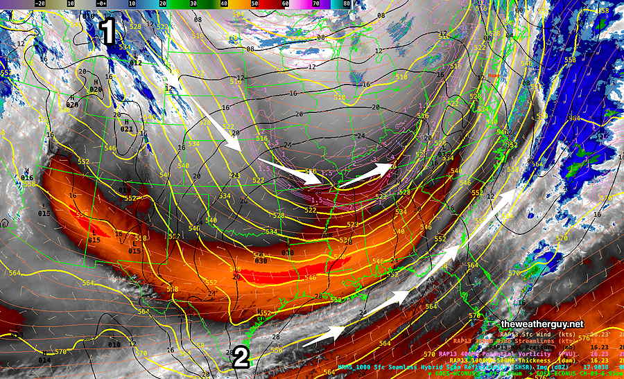
Posted Wednesday 01/17/24 @ 4:12 PM — An interesting development with this coming storm, as captured by today’s ensemble models and mentioned yesterday in the water vapor image caption.
It appears that the two low pressure systems will merge into one, with the possibility of throwing back additional moisture into our area.
Today’s 12z NAEFS shows merger of the two systems into a stronger coastal system. (Click on image for a larger view.)
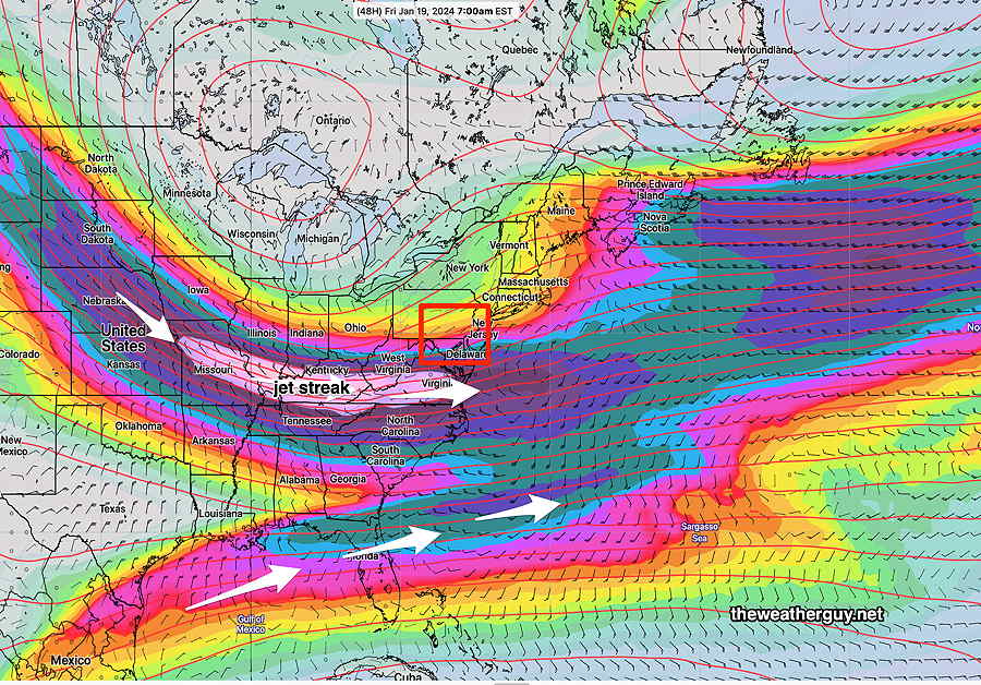
Additionally, we will be in a enhanced area of vertical upward motion caused by the jet stream, specifically an area that’s called the “left exit region of the jet streak”.
NAEFS jet streak position at 7 AM Friday. Our area (red box) is in the ‘left exit region” of the jet streak (area of enhanced speed in the jet stream flow) This region has enhanced upward vertical motion, causing enhanced precipitation. (Click on image for a larger view.)
This usually results in enhanced precipitation in this region.
Plenty of cold air should limit changeover to sleet and freezing rain to eastern NJ.
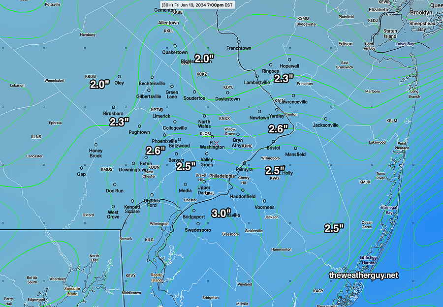
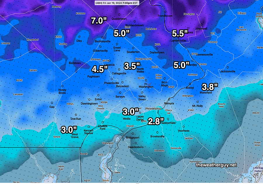
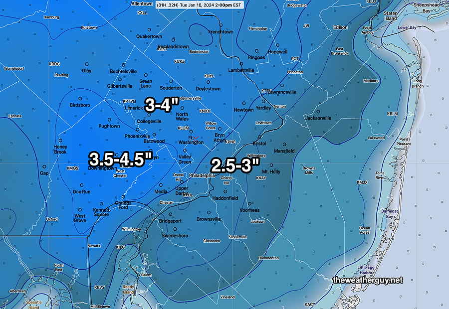
Putting this all together, I’ve assembled a new best estimate map of the expected snow totals—
My own snow total map. The first number in each area is the latest NBM forecast. The second number is based on the NAM-NEST forecast. (Click on image for a larger view.)
There’s still plenty of time for the models to change, but the ingredients are there for a larger storm.
Stay tuned.
Friday’s Snow
Posted Wednesday 01/17/24 @ 9:26 AM —The expected storm is still in the range of just a few higher resolution models (84 hour forecast range) but by later this afternoon, we’ll be entering into the range of most of the short range high resolution models ( 48 -60 hours).
Here’s the current view—
• This will be all-snow, no expected changeover to sleet of freezing rain in the immediate PHL area, except at the immediate shore. Low temperatures will result in higher snow-water ratios.
• The Global models (GFS, ECMWF, ICON, CMC) are forecasting a generalized 2″ – 2.5″ snowfall, beginning with light snow before daybreak Friday and getting heavier in the morning and into early afternoon.
• The shorter ranger models (NAM CMC-RGEM), both 84 hour forecast models, are closer to 2.5″- 4.5″
• The few 60 hour models (NAM-NEST, experimental RRFS) forecasts don’t include all of the duration of the storm but they’re suggesting 2.5 to maybe 3″.
So, at this point I’m thinking a likely 2.5-3″ snowfall, but it would not surprise me if this goes closer to 4″, and maybe 5″, northwest suburbs. The latest CMC-RGEM captures that forecast—
01-17-24 06z Canadian RGEM forecast snow, with some modification by me to adjust for temperature and existing snow totals. (Click on image for a larger view.)
I’m providing this just as a first “guesstimate”. I’ll be updating later today.
Another Similar Snowfall Friday?
Posted Tuesday 01/16/24 @ 10:06 PM — The Friday time frame has just entered into the range of the somewhat higher resolution models (84 hours).
Here’s the latest NAM, just available—
01-17-24 00z NAM model just available shows interaction between the two low pressure systems described in my the water vapor image below.. The NAM current forecast would be 3-4 inches of snow in our area Friday. The NAM is noted for over-estimating precip in the long term, so I expect this snow forecast to change, possibly greatly in either direction. (Click on image for a larger view.)
Things will change by Friday. Stay tuned.
Posted Tuesday 01/16/24 @ 7:40 PM — Following very cold weather for both Wednesday and Thursday, Friday appears to be shaping up for another rather similar storm like we had today. I’ve been covering it on my Winter OutlookPage
Still much uncertainty as this storm will again consist of two centers, one coastal and one inland. Some models are suggesting 3-4 inches of snow. Way to early to know for sure.
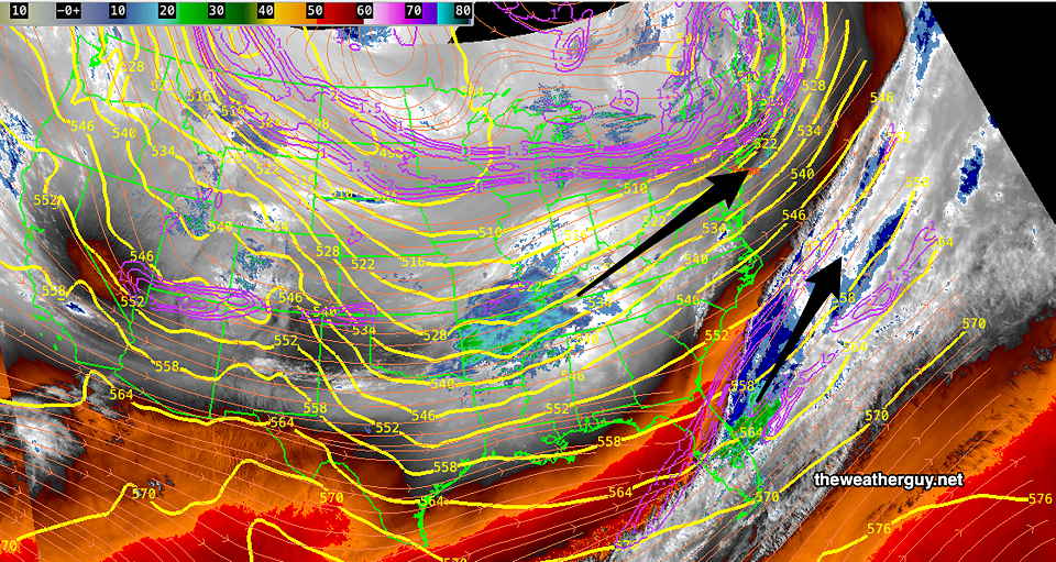
The energy for these systems are visible on satellite water vapor imagery—
01-16-24 Water vapor image shows disturbances (1) in the northern stream and (2) in the southern stream. These may interact with each other; too soon to tell. (Click on image for a larger view.)
Tuesday – Wednesday
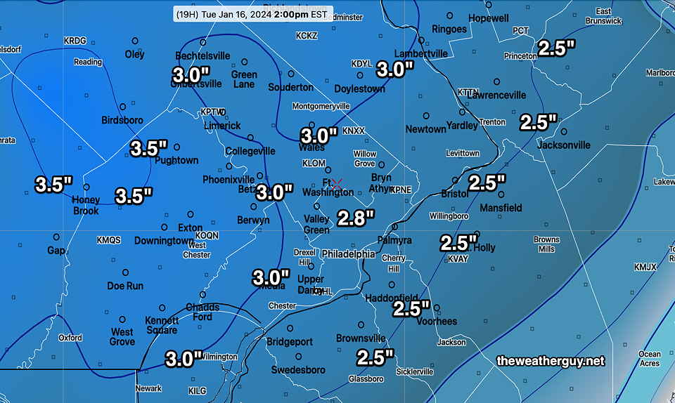
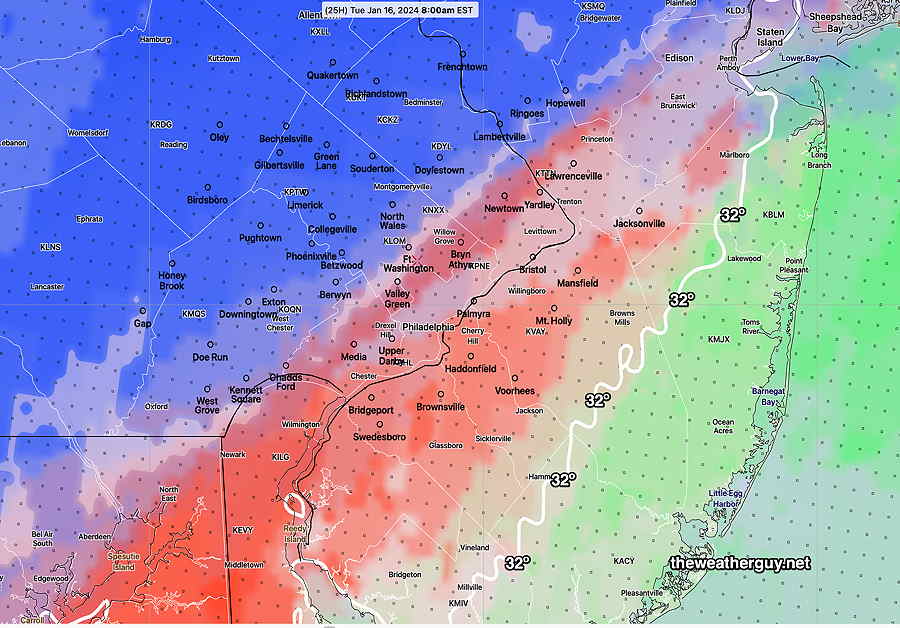
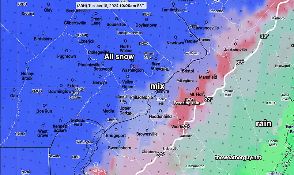
Posted Tuesday 01/16/24 @ 9:56 AM —Light precipitation, mostly freezing rain, possibly changing back to snow flurries until about 2-4 PM. It remains cloudy for the balance of the day, maybe some reduced cloud cover before sunset.
01-16-24 12z NBM precip type forecast at 2 PM today.
Wednesday looks to be clear and cold. Highs in the 20s.
In fact, it looks like we remain in winter’s grip through the coming weekend. Some winter weather possible Friday, covered in the Winter OutlookPage.
Update Mon 01/15 @ 9:47 PM— Eagles half time update: Latest NAM just available maintains the previous forecast, including the changeover to freezing rain/rain between 6 AM and 8 AM just north of the city. A change with tonight’s models: light snow/mix ends a bit later, between noon and 2 PM.
01-16-24 00z NAM model snow totals through 2 PM Tuesday (Click on image for larger view.)
Update Mon 01/15 @ 5:05 PM— Just wanted to post the latest GFS model snow totals, which show less of a changeover to freezing rain and higher snowfall amounts. Frequent visitors to this site know my mantra, “never ignore the NAM” when it comes to snow, but I’m thinking this may be the time to follow the GFS. I guess we’ll find out.
01-15-24 18z GFS snow totals. (Click on image for larger view.)
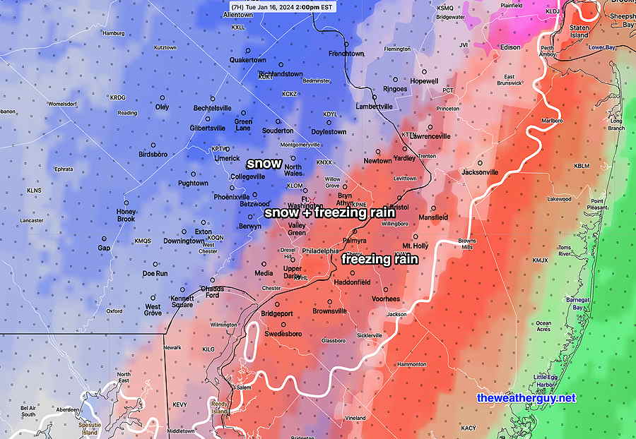
Posted Monday 01/15/24 @ 4:11 PM —We’ve had some non-accumulating flurries break out ahead of the main area of precipitation. The accumulating snow will develop, from south to north, between 6 PM and 8 PM.
Here are the trends based on the latest models:
• Expected snowfall totals continue to slightly increase but may reach their maximum about 6-8 AM Tuesday before being tamped down by freezing rain and sleet. • Transition to freezing rain is likely to occur further northwest of the city than previously forecast. • Precipitation ends as snow flurries about 10 AM to noon.
The transition from snow to freezing rain/sleet occurs in this area between 6 AM and 9 AM as shown below—
01-15-24 18z NAM forecast precipitation type. (Click on image for a larger view.)
The final snow totals will depend upon how accurate the transition to from snow to freezing rain/sleet is forecast. Here’s the latest NAM-NEST snow totals which assumes a significant changeover from snow—
01-15-24 18z NAM-NEST snow totals (Click on image for a larger view.)
Should the changeover not occur, an additional 1.5 inches is possible. The RGEM captures that scenario—
The Canadian RGEM captures a somewhat colder storm—
01-15-24 12z Canadian RGEM total snow (Click on image for a larger view.)
Snow Update
Posted Monday 01/15/24 @ 8:49 AM — Some of this morning’s 12z model runs are beginning to become available. Here are the current trends with the light snowfall expected Monday evening into early Tuesday—
• Light snow overspreads the area, from south to north, from 6 PM to 8 PM • Light snow continues through the night • A changeover to sleet and mostly freezing rain occurs, from southeast to northwest, beginning at 6 AM Tuesday. • The NBM shows a transition to freezing rain extends just beyond the city limits by 9 AM, reducing snow totals in this area. • Light precipitation ends as flurries between 11 AM and 1 PM Tuesday.
01-15-24 12z NBM Precipitation TYPE forecast at 8 AM Tuesday (red/orange= freezing rain) (Click on image for a larger view.)
Here’s the latest NAM forecast snow accumulation, which may be on the high side—
01-15-24 12z NAM snow accumulation (Click on image for a larger view.)
Here’s the NBM snow accumulation which may also be on the high side—
01-15-24 12z NBM snow accumulation through 11 AM Tuesday (Click on image for a larger view.)
I’ve posted the available NBM 12z model data. The NBM specifically updates precipitation in it’s 13z model run. I’ll post an update if there’s a significant change.
Check back later this afternoon.
Previously Posted Sun 9:25 PM —
An upper air trough and cold high pressure will be a dominant factor in our weather this week. With the trough in place, disturbances developing along the edge of the trough will combine with energy from an active southern branch of the jet stream will allow at least two possibilities for winter weather storms this week.
The current water vapor captures the situation today and the scenario for late Monday into Tuesday’s storm—
Current satellite water vapor shows two disturbances that will interact and affect our weather late Monday into Tuesday. The northern disturbance will be the primary weather maker for us and its inland track will bring in some warmer air aloft late Tuesday. Some unknown affect of the southern disturbance may increase the uncertainty with this system regarding available moisture and the thermal profile: snow vs mix vs rain. (Click on image for larger view.)
Monday: Following a cold sunny start of the day, high clouds will quickly be replaced by cloudy conditions by early afternoon. Light snow moves in from the south between 5 PM- 7 PM. Highs likely won’t reach 32º in most areas.
Tuesday: Light snow continues into daybreak Tuesday. Only about 1 inch to 1.5 inches are likely by 8 AM, at which point there will be a transition to sleet and freezing rain/rain in some areas from southeast to northwest. (The latest ECMWF is colder.) Temperatures remain below freezing for much of the area northwest of the city, so freezing on surfaces may be an issue. Precipitation ends around noon.
Here’s the NBM precipitation type at 10 AM Tuesday, just before ending as flurries around noontime—
01-15-24. 00z NBM Precipitation Type at 10 AM Tuesday morning. (Click on image for larger view.)
The total water equivalent expected to fall is between 0.17 and 0.35 inches of water. Due to melting and compaction, the models are forecasting anywhere from 1-2.5 inches of snow with a mix of sleet on top. (If it were to fall as all snow, it might be as much as 4+”.) Here’s the NBM forecast —
Tonight’s 00z NBM cumulative snow accumulation (Click on image for larger view.)
The latest HRRR and NAM, just available while writing this, is trending colder and snowier—
01-15-24. 00z HRRR just available is colder without the transition to sleet in the city and with somewhat more snow accumulating. (Click on image for larger view.)
Temperatures may barely exceed freezing, so icy conditions may be an issue despite the relatively low accumulations.
There’s plenty of time for things to change. Check back tomorrow.
I’m keeping my eye on a potential system on Friday. See preliminary comments on my Winter OutlookPage.