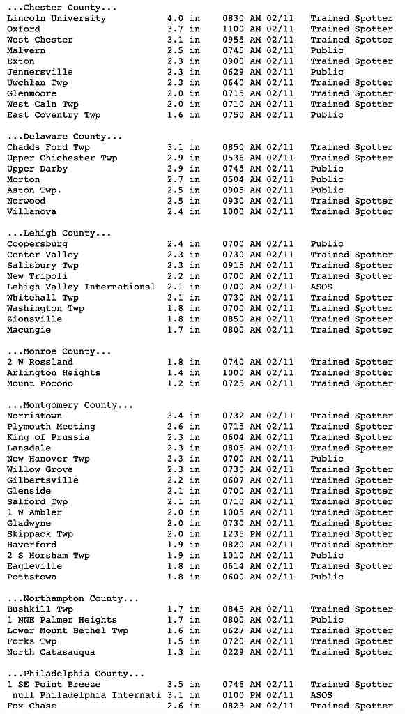
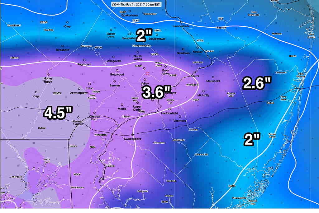
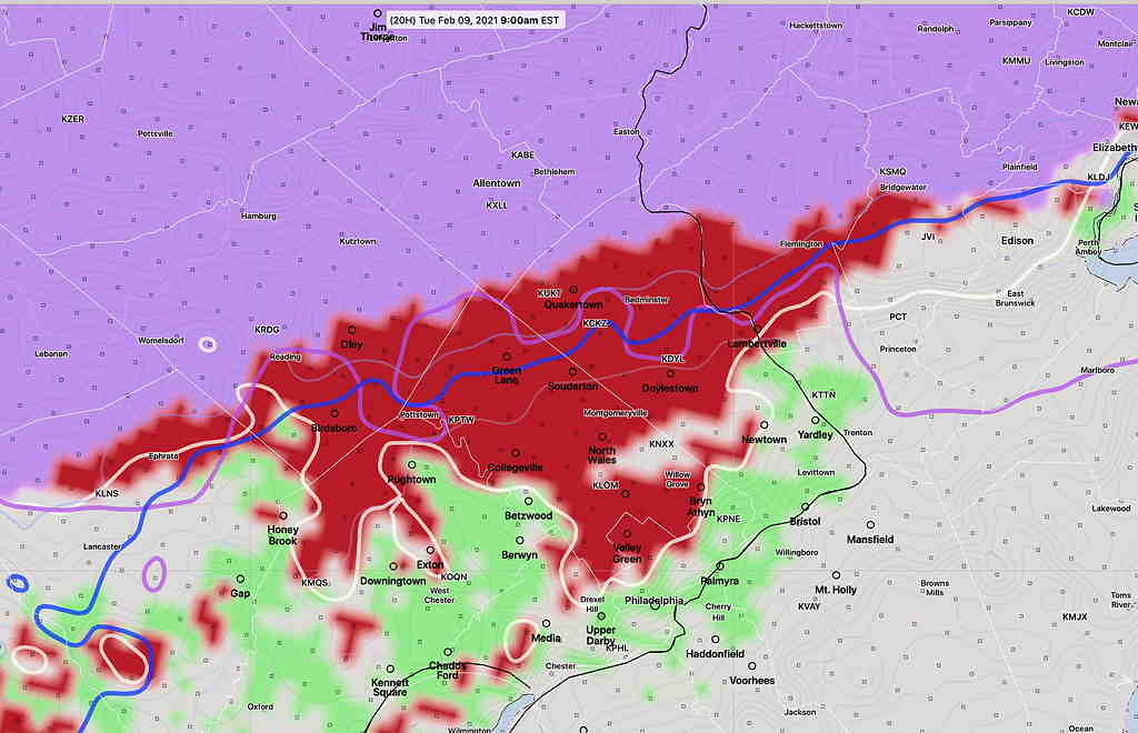
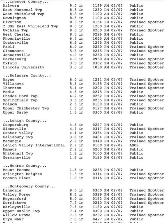
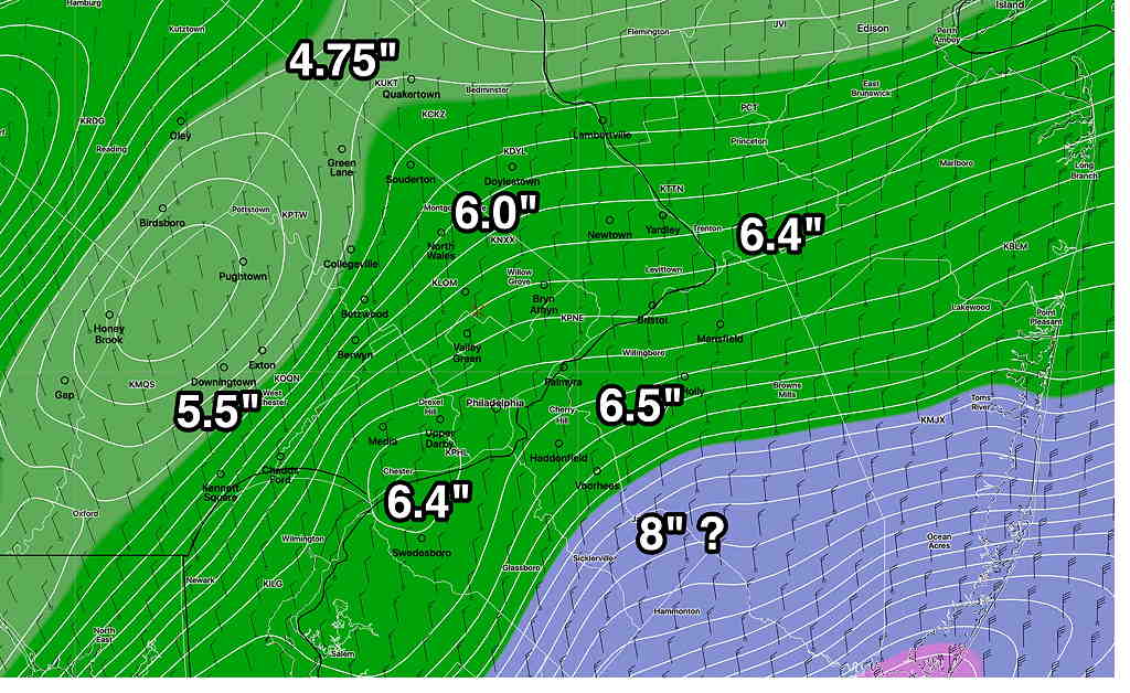
Thu 04:15 PM Forecast Review — Here are the official NWS snow totals for the immediate PHL area for Wednesday night’s snowfall.
Snow totals from the NWS (Click on image for a larger view.)
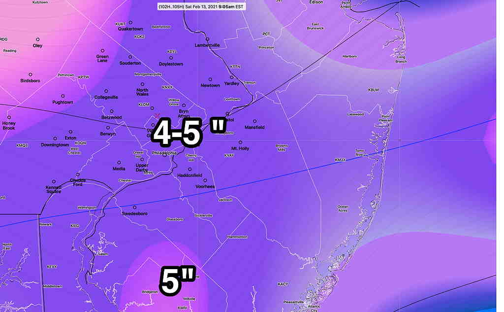
Forecast Updated Wed 10:50 PM —Tonight’s GFS is unchanged from this afternoon’s model run and remains about 1 inch greater than the NAM posted just below. In past years, an average between the GFS and NAM models has worked. We’ll know by mid to late morning tomorrow.
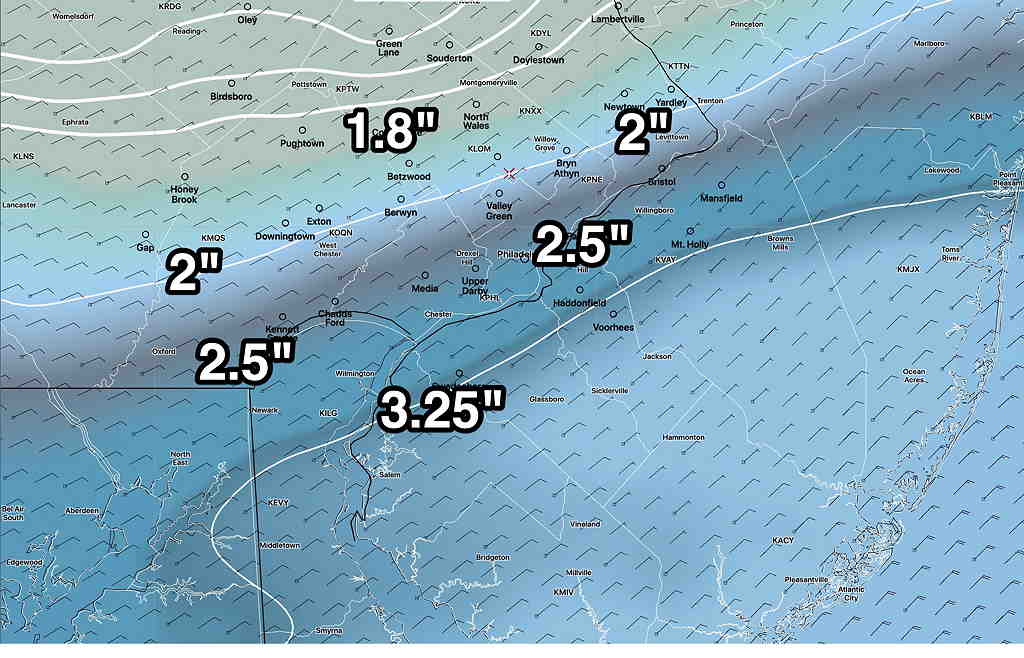
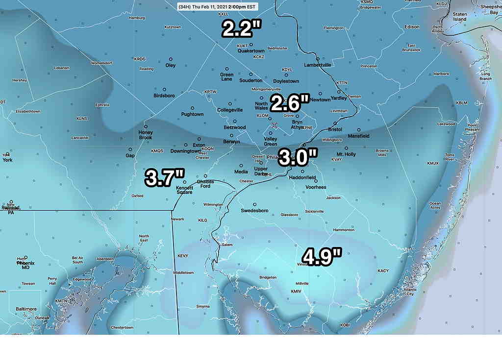
Forecast Updated Wed 9:45 PM —Tonight’s HRRR, RAP, NAM and NAM-NEST models just became available and they have brought down the snow totals a bit from the afternoon models. Here’s the latest NAM—
Tonight’s NAM 00z model with snow totals based on a 10:1 snow water ratio (Click on image for a larger view.)
Also available at this hour is the new WRF-ARW, whose snow totals are similar to the afternoon ranges below. So I think we’re splitting hairs here, as we all know that the models can’t really be this precise. I think we’re back to the 2-4″ range for the immediate Philadelphia area, less further north.
The new GFS and Canadian models won’t be available until after 10:30 PM. If I’m still awake, I’ll update! 🙂
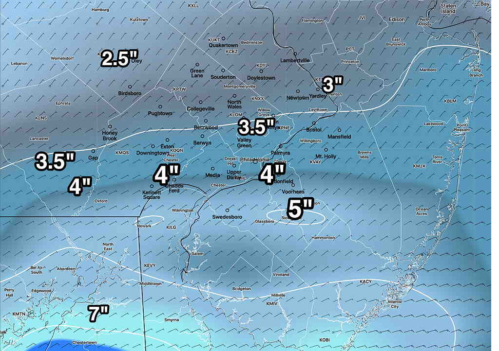
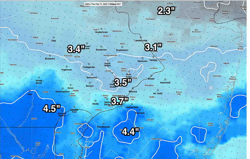
Forecast Updated Wed 5:26 PM — The models are on-board with snow for tonight (Wednesday), developing between 8 and 10 PM and ending about 10 AM Thursday. This afternoon’s GFS has just come out (I’m using the soon-to-be-released GFS v.16 here)—
GFS v 16 Snow accumulation based on Water-Snow Equivalence 10:1 (Click on image for a larger view.)
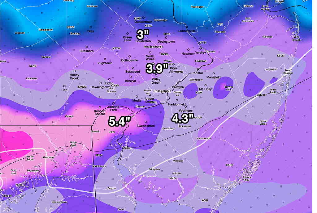
To present another viewpoint, here’s the latest Canadian Regional “GEM” model—
CMC- Regional GEM Snow Water Rate (Click on image for a larger view.)
It still looks like the Friday storm will miss us, passing by to our south. Another, more-developed storm is now scheduled for Saturday afternoon instead of Sunday. This also looks like the bulk of its snow will pass to our south, but some accumulation is expected here. Stay tuned for updates.
Forecast Posted Wed 9:10 AM —
The latest models have converged on a similar snow accumulation forecast for Wednesday night into Thursday morning. (At least that’s the case right now. )
The impulse moving in from the west will pass just to the south of us. We’ll be on the cold side of the ‘storm’. As mentioned last night, the somewhat greater accumulations will be just south of Philadelphia.
Current RAP (Rapid Update) model (Click on image for a larger view.)
HRRR (High Resolution, Rapid Refresh) model (Click on image for a larger view.)
Model Blend NBM (Click on image for a larger view.)
Things may change, as they always seem to do. That said, there’s pretty good agreement with these models.
As for the second storm that had been expected to affect us later Thursday into Friday, it appears it will be moving to our south, essentially missing us.
There’s additional uncertainty about the weekend storm; its track seems to be further south as well.. Stay tuned.
Forecast Updated Tue 10:25 PM — Tonight’s models have begun to come in. The trend is for both Wednesday night’s impulse and the second one to take an increasingly southern track. Areas from Philadephia and north will have 1-2 “, but areas south (southern Delaware, Chester counties and southern NJ) may have 2-4 inches. The second disturbance later Thursday into Friday may miss us entirely. Stay tuned .
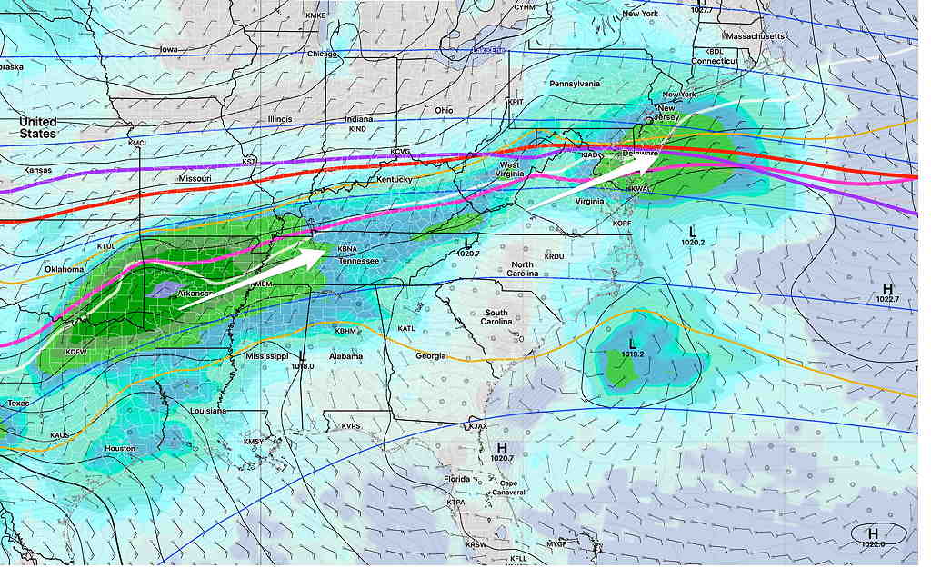
Forecast Updated Tue 5:53 PM — The setup described yesterday continues to evolve into a complex and uncertain forecast as several impulses develop from a plunge of cold arctic air. The first impulse will move through late Wednesday evening into Thursday morning. Snow totals of about 3 inches are possible by noontime Thursday morning, but the snow may continue into Friday as the second impulse moves in.
The forecast beyond noontime Thursday becomes unclear.
Some models have moved the track of this second impulse on Friday to our south; the second impulse may miss us.
SREF forecast Thursday morning showing the two impulses. (Click on image for a larger view.)
It’s unclear if these impulses will arrive as discrete, separate systems or whether they will be diffuse less potent and more disorganized.
The model blend (NBM) has snowfall from Thursday into Friday with periods of heavier snow Thursday and again on Friday. There is much uncertainty with these multiple systems.
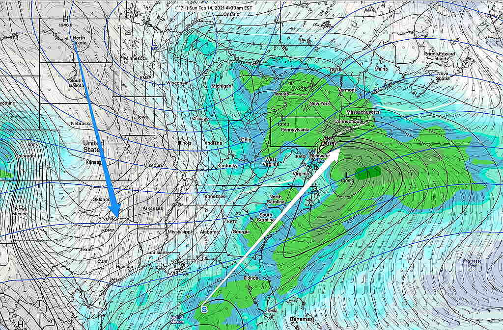
The GEFS continues to forecast a nor’easter for us late Saturday into Sunday
GEFS showing plunge of cold air (blue arrow) and track of coastal low (white arrow) (Click on image for a larger view.)
Stay tuned…
Forecast Updated Tue 9:03 AM — The very light snow/freezing rain that had been expected early today is likely to stay to our north this morning. The areas of positive vorticity as depicted on yesterday’s map will be the only areas getting any precip from this weak disturbance.
The latest ICON model shows a more significant snowfall for late Wednesday through Thursday with a generalized 4-5 inches of snow total by Friday morning
ICON Snow Forecast for late Wednesday through Thursday (Friday morning totals) (Click on image for a larger view.)
We all know that these numbers are not worth that much at this point in time, but it’s useful to know that significantly more snow is possible.
Stay tuned
From Monday at 5:54 PM…
Cold air that had been sequestered in Canada for much of January has begun to plunge into the continental US. The plunge of cold air is such that it will push the jet stream south, providing a boundary and track to bring stormy weather to the Philadelphia area over the next week or so.
GEFS Temperature forecast for Sunday showing region of likely storm development (Click on image for a larger view.)
As this week progresses, several weaker disturbances will affect our area as this boundary develops into a highly amplified jet flow. Two relatively weak disturbances will affect us prior to Sunday’s storm.
Tuesday
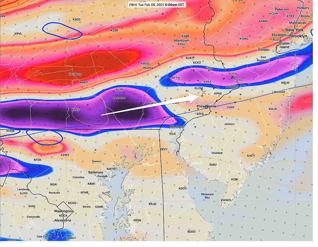
A mid-level disturbance (areas of “vorticity” at 14,000 feet and above) will move through in the early morning Tuesday. There’s hardly a surface low pressure development with this disturbance, but it shows as vorticity maxima—
NAM 700 mb and 500 mb absolute vorticity Tuesday 6 AM. We’ll be in the area of negative vorticity (blue and violet), limiting the precipitation, but areas to our north will have significantly more precip.(Click on image for a larger view.)
Though moisture is limited, there will be enough lift to cause precipitation. The precipitation will move in prior to temperatures warming up. There’s a very good chance of very light snow and very light freezing rain, maybe sleet, during the period 6 AM -10 AM Tuesday morning.
NAM-NEST PTYPE 9 AM Tuesday (red =freezing rain) (Click on image for a larger view.)
Most models are on-board with this forecast, but be advised that in recent storms, the models have been too cold at the surface and freezing rain hasn’t materialized. This time, both the GFS and NAM model groups have the freezing line just south of Philadelphia at the start. Accumulations won’t be an issue here in Philadelphia, but slippery conditions are likely. (Total QPF is about 0.10 inches water)
Wednesday Night into Thursday
A similar setup is expected to move in late Wednesday into Thursday. This disturbance will have more moisture and is expected to be stronger than Tuesday’s with maximum lift area over the PHL area. The Canadian models have been consistent moving this in Wednesday afternoon, but most other models keep the onset timing early Wednesday evening through Thursday morning. Current snow forecasts range from 1-3 inches.
GFS forecast 8 AM Thursday morning (Click on image for a larger view.)
Sunday
A more significant coastal storm is expect to affect us on Sunday, the result of the plunge of cold air and the resultant amplified jet configuration, as mentioned at the beginning of this post. No details right now, but significant snow is possible. Some models have this storm approaching as early Saturday evening.
GEFS Surface Forecast Sunday 1 PM (White line is near ground level freezing isotherm) (Click on image for a larger view.)
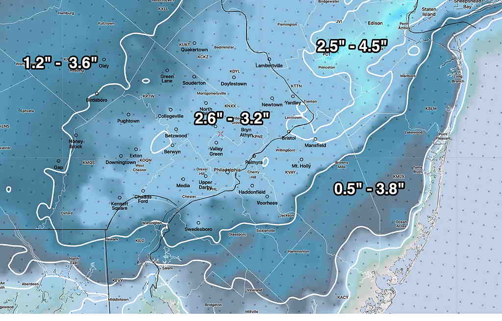
Sun 1:45 PM Forecast Review — What would have been my forecast if I had used last night’s NAM for the snow totals (which I did not)? —
NAM from 7 PM Saturday; Snow forecast based on accumulated precip converted to snow at 1:10 ratio. The 8″ amount is questioned because the snow was expected to mix with rain.
Every storm is different and a learning experience. The Model Blend (NBM) is supposed to do all the heavy lifting for a forecast, but it hasn’t been too good at blending or there’s bad info going into the blender.)
One more thing. Official Final Snow totals DO include compaction. (We have 4 inches at 12:24 PM.) If you shovel away 3″ of snow and you measure another 3″, the total snowfall isn’t necessarily 3+3=6. Official snow totals are measured immediately after the snow stops and the model algorithms assume compaction based on PTYPE, temperature, density.
Forecast Updated Sun 11:20 AM — We have an interesting comment from Downingtown that they have gotten six inches on metal surfaces, 4 inches on driveway.
The latest GFS model run from 7 AM just became available at 10:38. Incredibly, it only show 4.3 inches of snow (for Downingtown!). Here, I have about 3.0-3.5 inches at 11 AM.
Only the NAM has (may have) gotten this right, with about 5-6 total inches consistently forecast for the PHL area. While I mentioned the NAM model’s higher totals each previous post, I discounted it in favor of the NBM. It’s all a learning experience. (Interestingly, the NAM had much more sleet and much less snow during our last 48 hour storm. Go figure!)
The latest hourly HRRR has snow ending about 3 PM ± 1 hour.
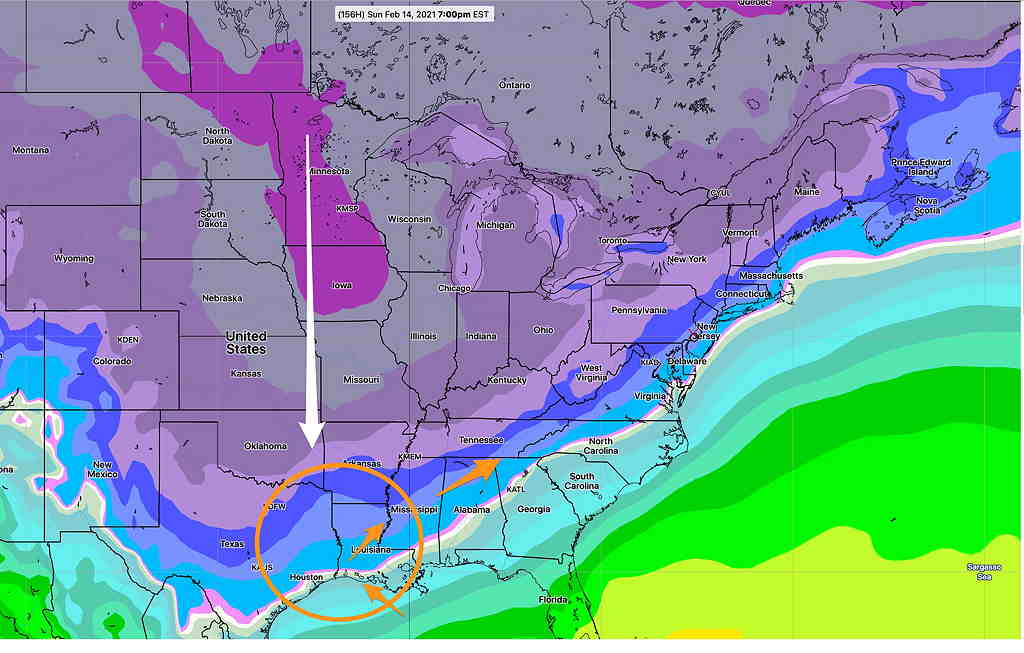
Forecast Updated Sun 9:33 AM — This morning’s models have become available. The main heavier axis of precip (rain/snow) has shifted east into NJ. The complicating issue in predicting snow accumulation is that the temperatures in NJ for the heaviest snow are forecast to be 35º and some precip will mix with rain in NJ.
Temperatures near ground are a bit warmer than forecast, allowing considerable snow compaction, lowering final totals in some areas.
Here’s the latest Model Blend (NBM) from 12z (7AM)
NBM (7AM model run Snow forecast.) I’ve gone to the higher range of percentiles. Notice the range in NJ is much larger than in Philadelphia indicating higher uncertainty.
I’m still working on this forecast. Posting it as incomplete at 9:33
Forecast Continued Sun 10:02 AM — The RAP continues to forecast about 4 inches of snow for the immediate PHL area.
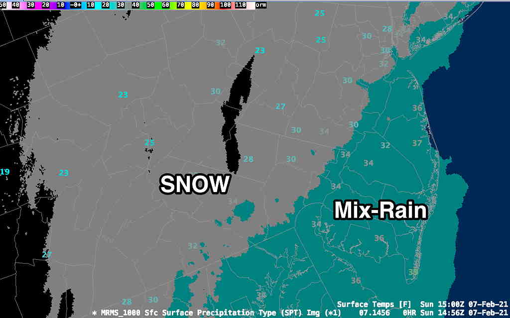
Here’s the real-time NWS MRMS (Multi-Radar Multi-Sensor) precipitation type and temps at 10AM—
NWS MRMS Live data capture at 10 AM, showing transition to mixed in NJ which current temperatures are above 32º