#Philadelphia #weather #PA
Friday Night Light Snow Update
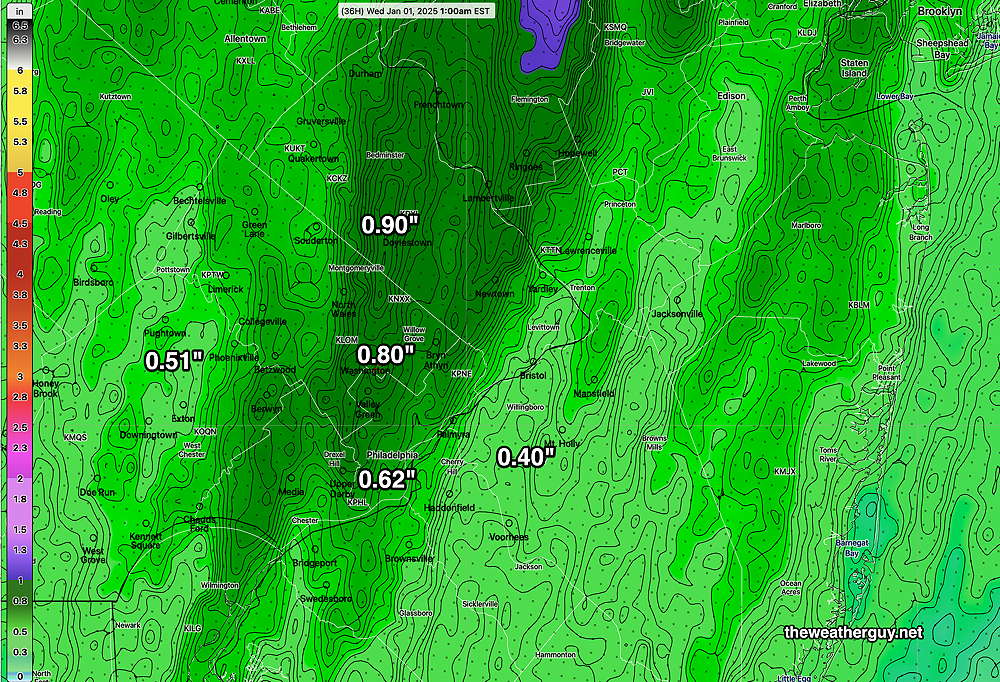
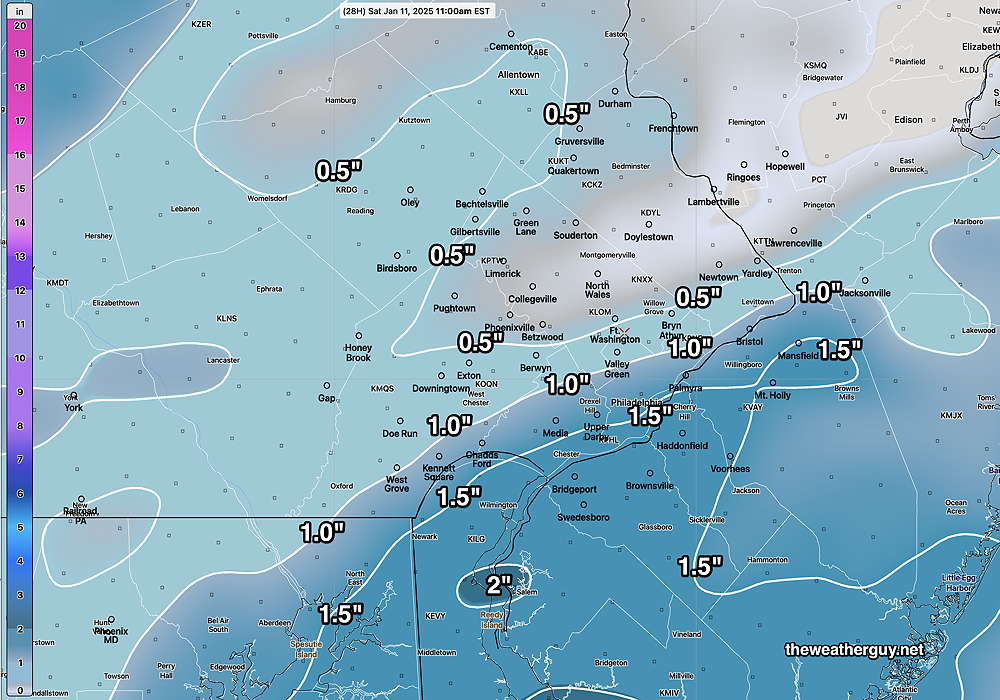
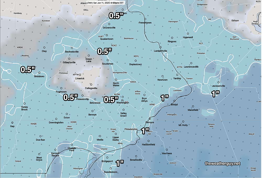
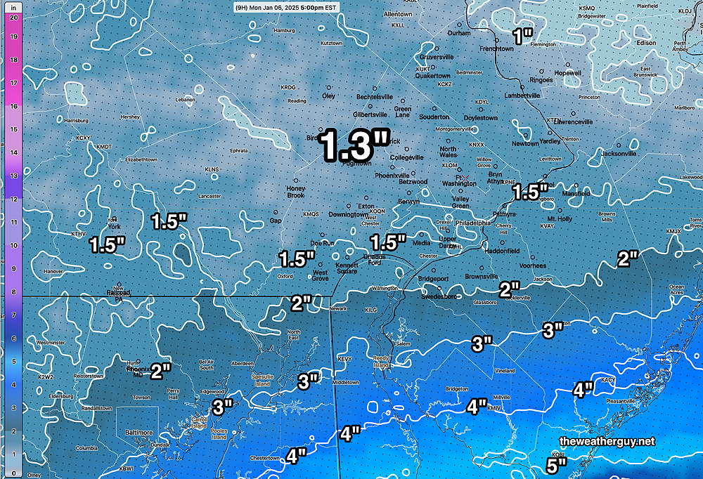
Posted Friday 01/10/25 @ 9:15 AM — The latest NAM (12z) just became available. Here’s its snow totals for tonight, starting about 11 PM and ending about 8 -9 AM Saturday morning.
Due to the highly unbalanced political environment on X, I’ve considerably cut back auto-posting there. To receive all forecast postings, I recommend following me on mastodon.social or bluesky.social
Friday though Sunday Weather Outlook
Posted Thursday 01/09/25 @ 5:10 PM —Gradually moderating temperatures Friday through Sunday. Lincoln Field may see 39º-40º on Sunday afternoon.
Friday— Sunshine in the morning, thickening clouds in the afternoon.
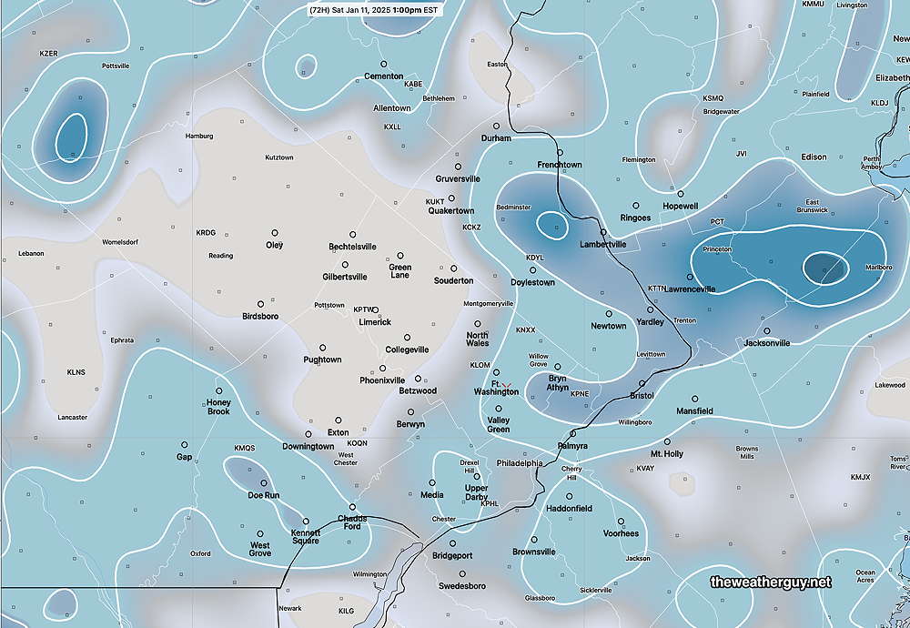
Saturday— Each day’s forecast has seen decreasing amount of snow accumulation for Philadelphia. The latest model blend (NBM) precipitation update at 19z shows minimal and variable snow accumulation here in Philadelphia and areas north and west. It’s low values are the result of many of its constituent models showing almost no snow—
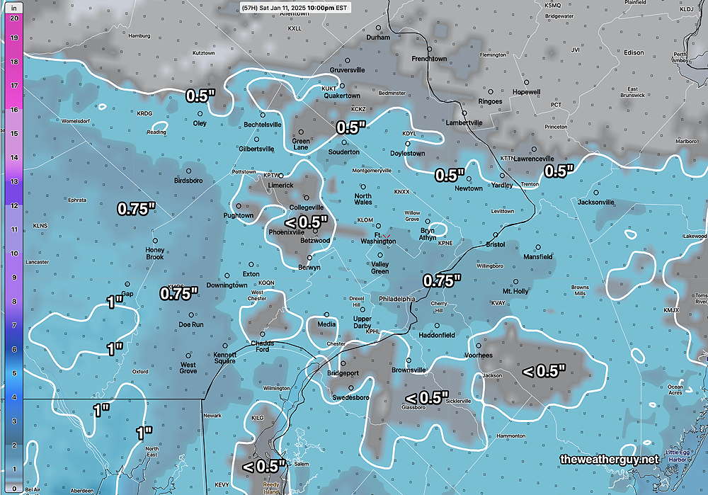
Regulars here know I always value the NAM when it comes to snow here. The NAM shows more snow than the NBM—
While the NAM appears quite different than the NBM, the entire range of snowfall for both models is quite low.
Sunday looks to be mostly sunny and not all that windy for the Eagles game. Highs 39º-40º
Thursday through Saturday Outlook
Posted Wednesday 01/08/25 @ 5:05 PM — Continued cold weather with a slight moderation Saturday.
Thursday— Clouds very early, then sunny and continued cold.
Friday— Sunny early, then gradually thickening clouds for the balance of the daytime hours.
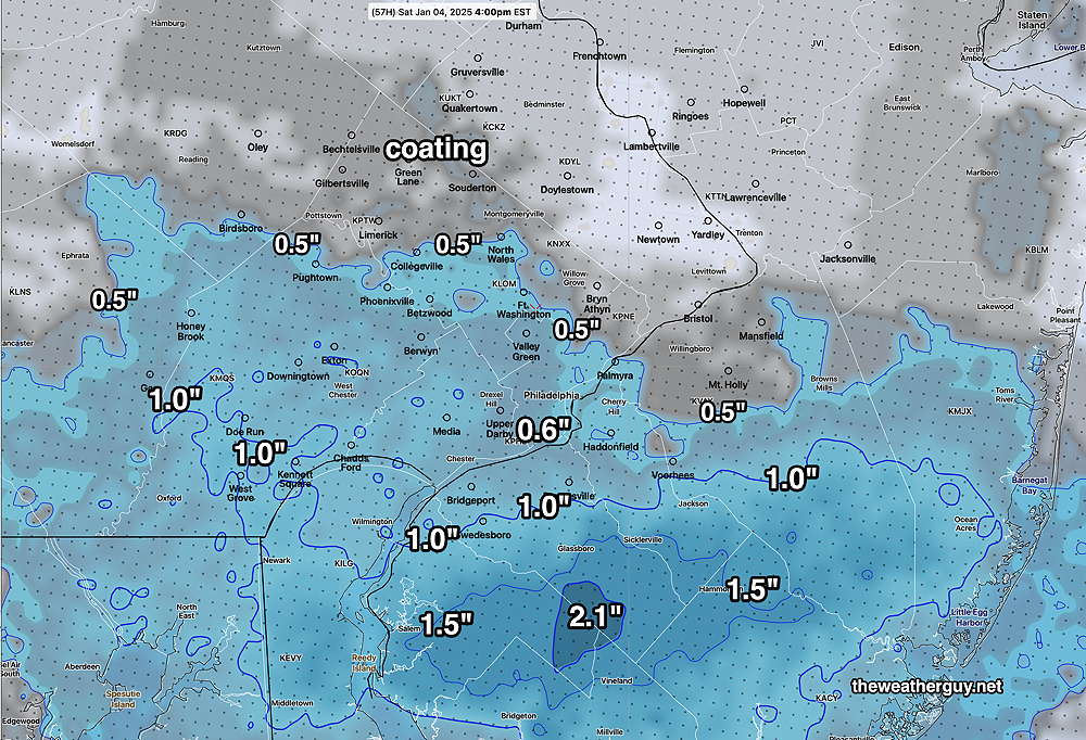
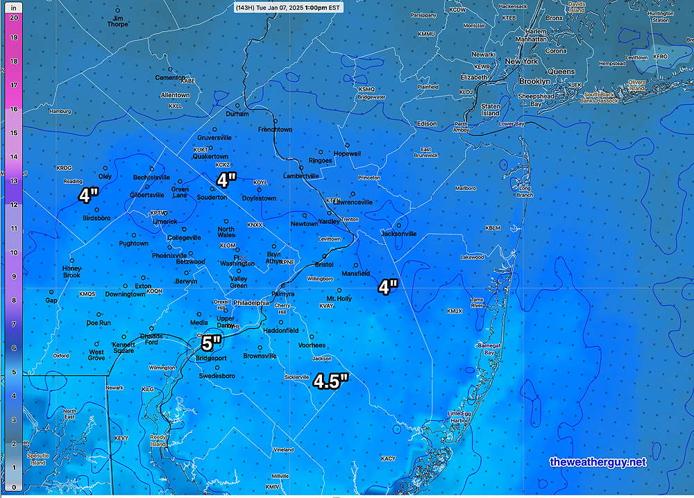
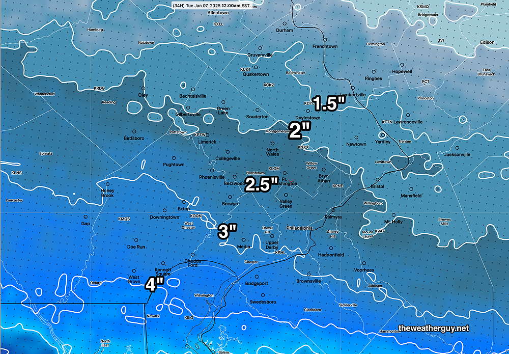
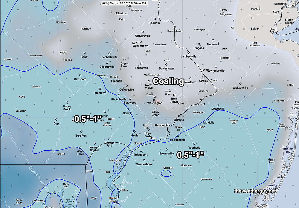
Saturday—The storm that had been expected on Saturday increasingly looks to move to our south and any snow we receive will mostly be due to a weak upper trough that moves through in the morning. Any snowfall looks spotty and likely less than an inch.
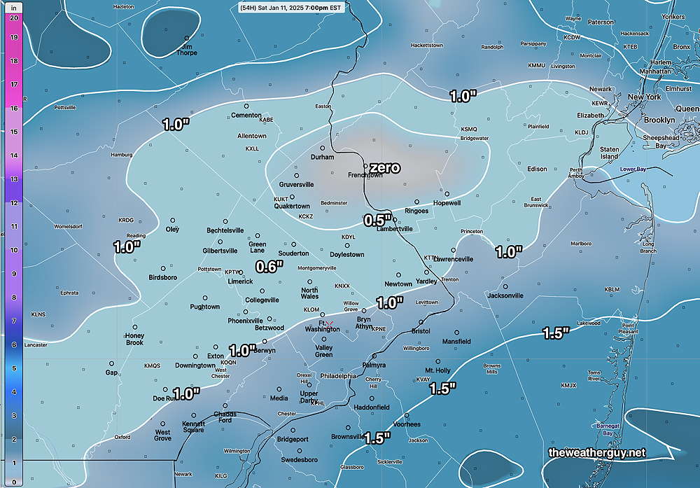
Here’s the latest NBM snowfall forecast for Saturday—
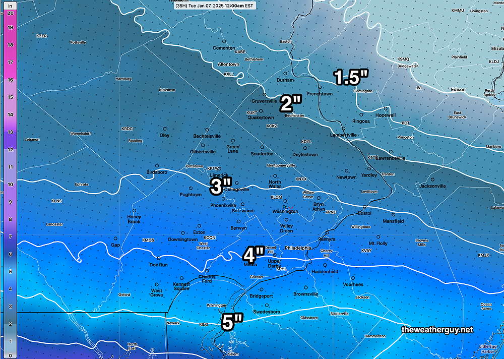
The NAM’s forecast is much more spotty—
The ensembles still show uncertainty in the track. Stay tuned.
Wednesday through Saturday Outlook
Posted Wednesday 01/08/25 @ 9:05 AM — The forecast for periods of cloudiness today seems to be on-track. There should be some periods of sun and additional periods of cloudiness.
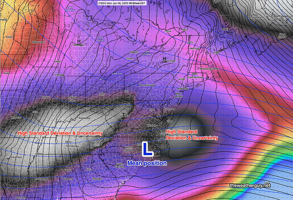
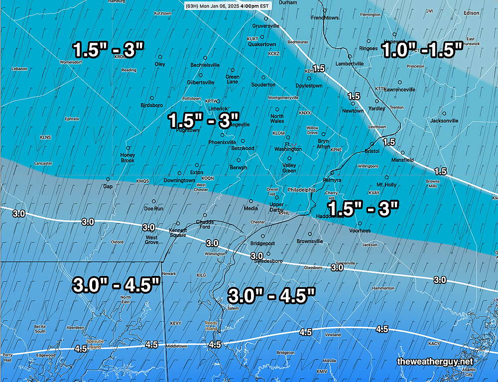
As for Saturday’s potential light snow, the models have come closer together forecasting about 1 inch, some possibly of as much as 1-2 inches falling mostly Saturday morning. There’s still uncertainty in the speed and track, as shown by the latest ECMWF ensemble (statistical) model—
Updates late this afternoon.
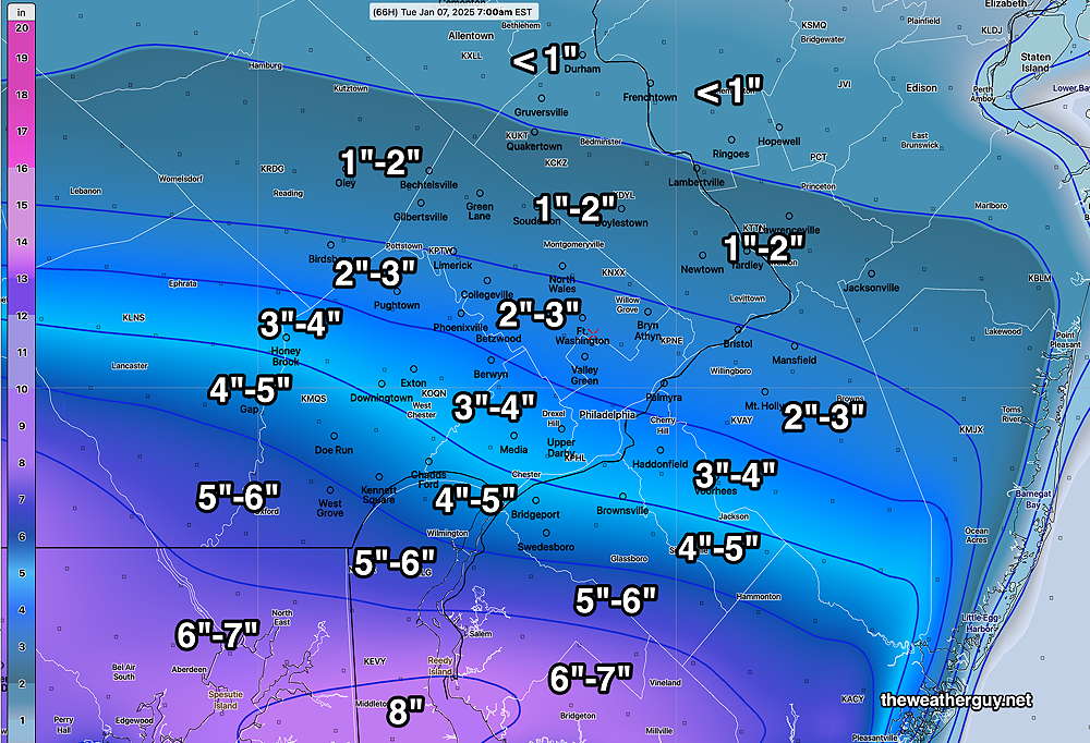
Posted Tuesday 01/07/25 @ 9:58 PM —Later models today and this evening are leaning towards a more southern storm track. Possible snow Saturday is looking closer to an inch or so accumulation. Updates tomorrow.
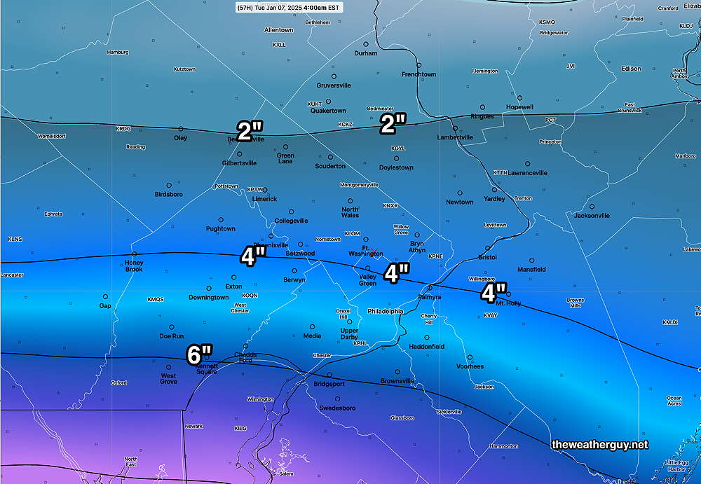
Posted Tuesday 01/07/25 @ 5:39 PM — The cold weather is expected to continue through Friday. A low pressure system off the coast will likely bring some snow on Saturday.
Here’s the highlights for the coming days—
Wednesday— Cold, with a bit more cloudiness at times during the day
Thursday— Sunny and continued cold.
Friday— Sunny early, then thickening clouds in the afternoon.
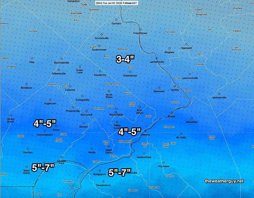
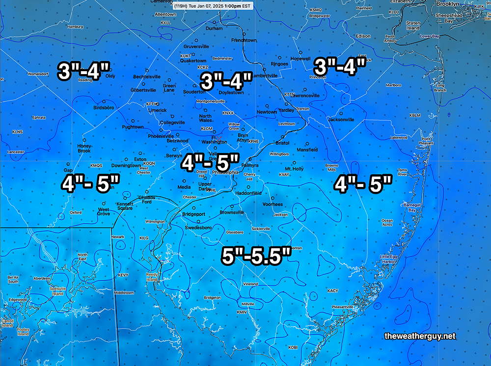
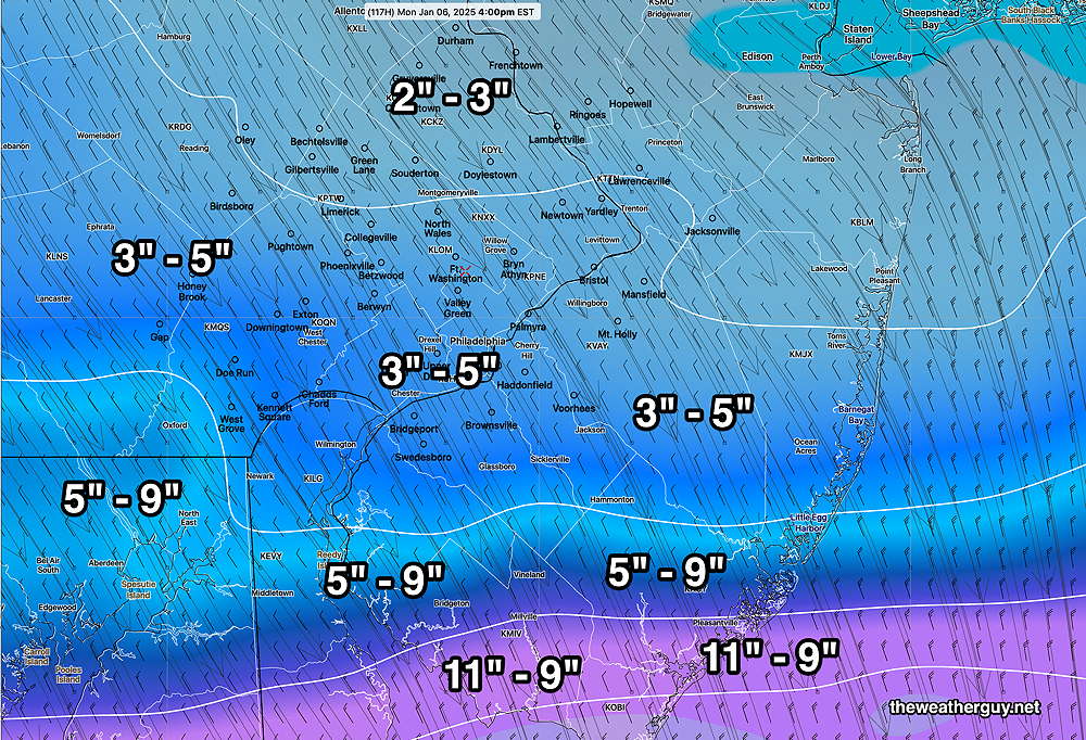
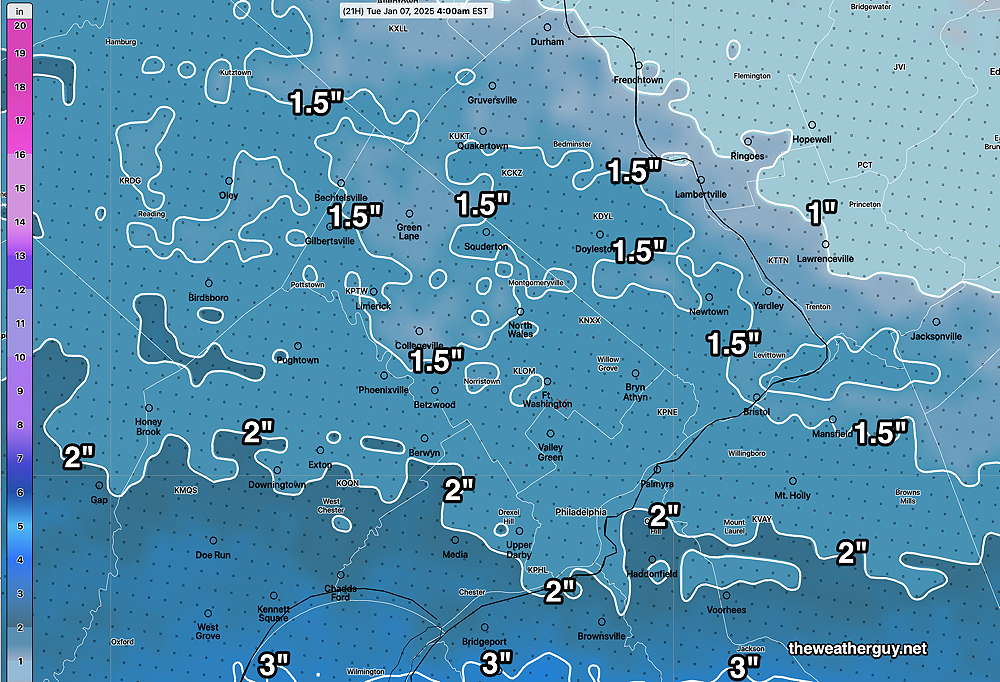
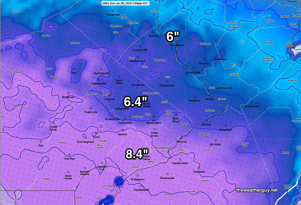
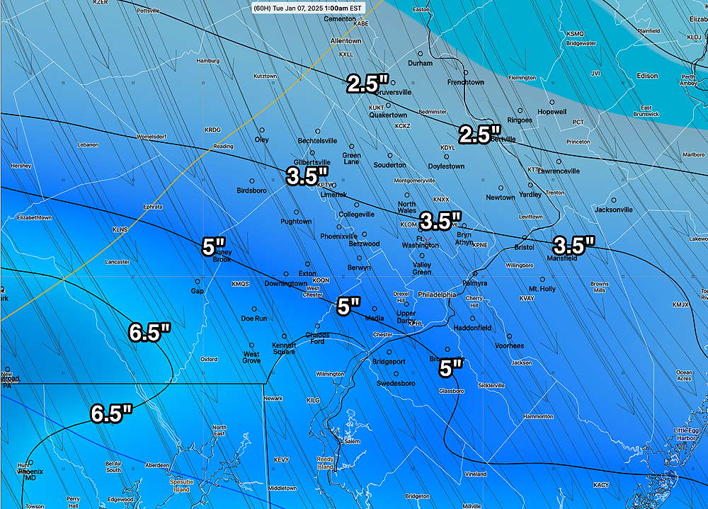
Saturday — The models are coming closer together with the ECMWF now somewhat closer to the coast and the GFS somewhat further east with its coastal forecast than it was showing yesterday. Snow appears likely, but a change to sleet SE of the city looks likely as well. Current snowfall in the 2-4″ range is currently forecast, but that will change in either direction.
Here’s the latest GFS forecast for Saturday—
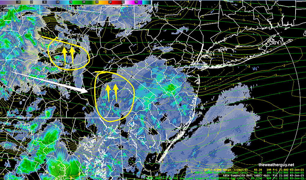
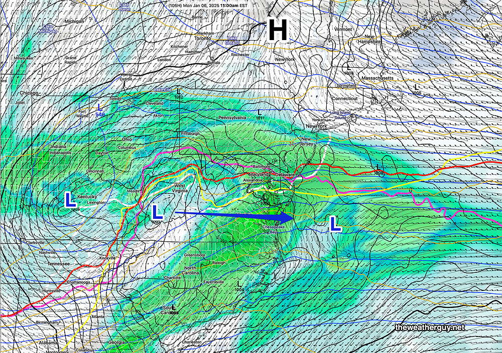
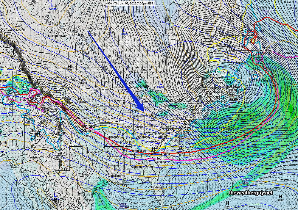
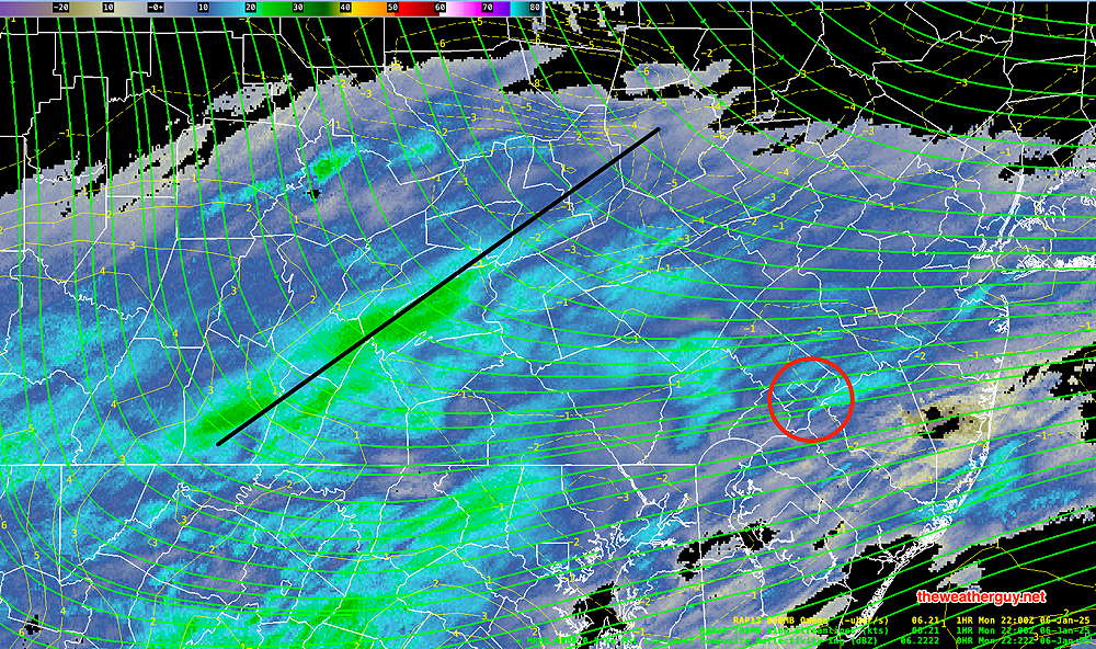
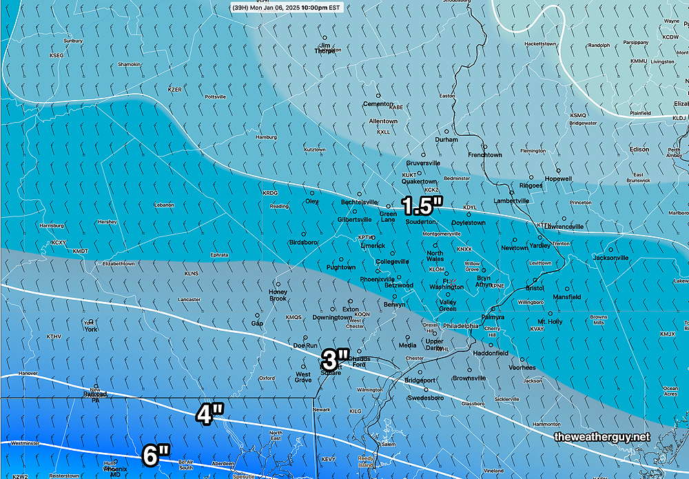
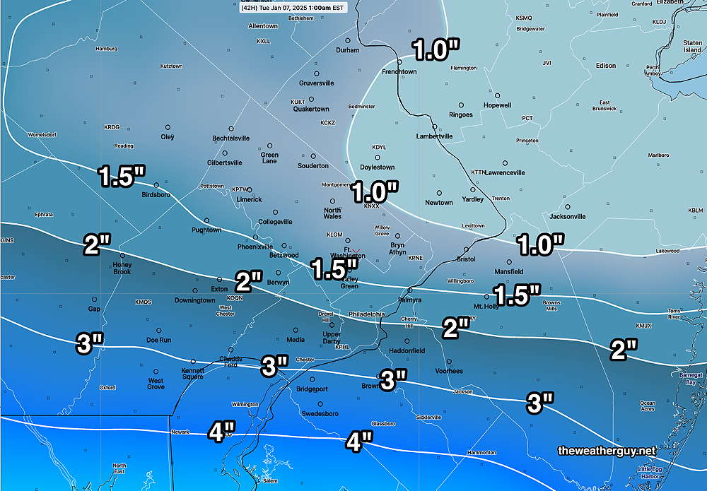
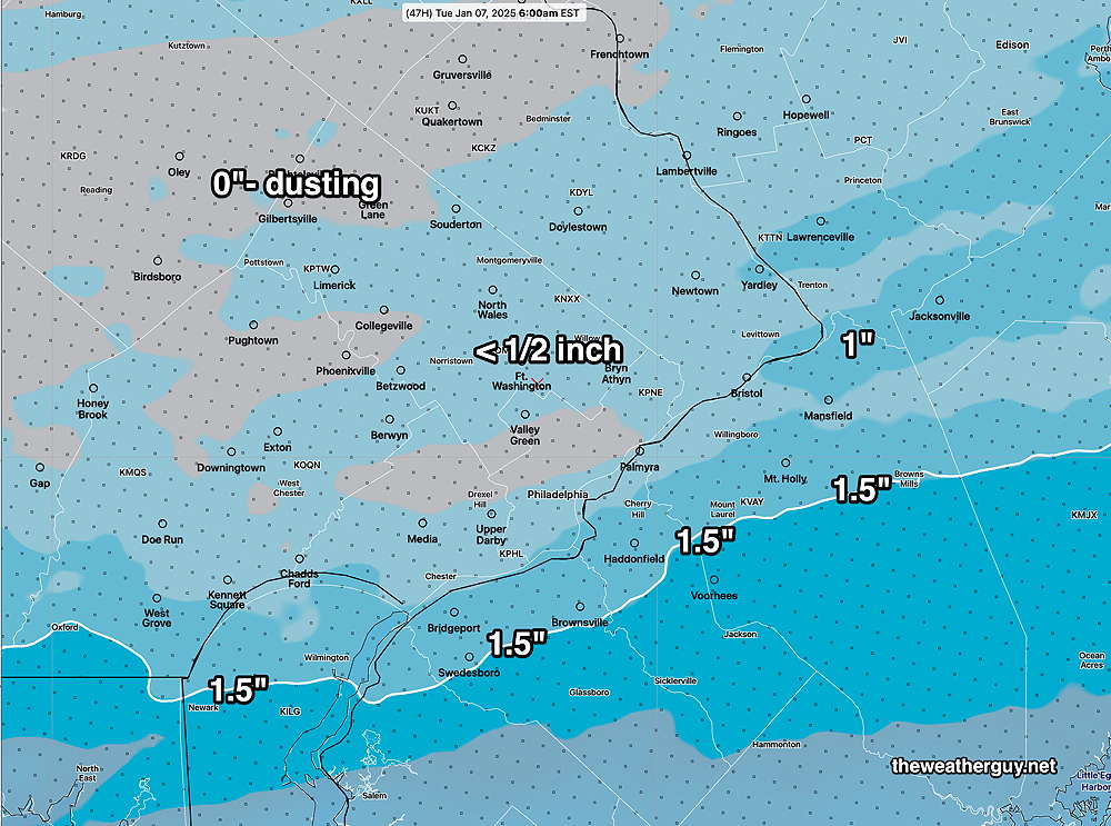
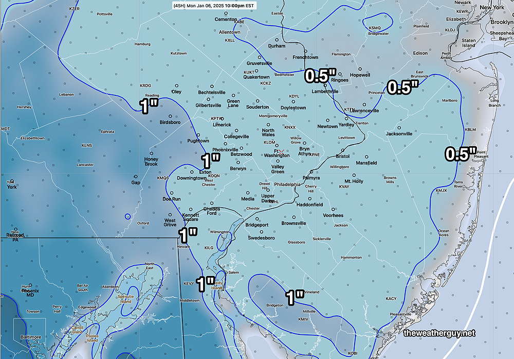
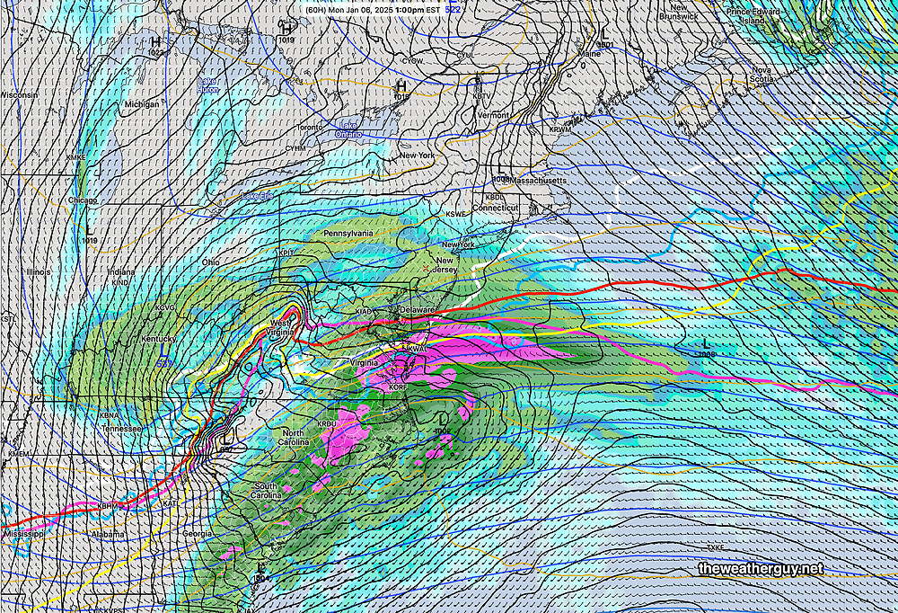
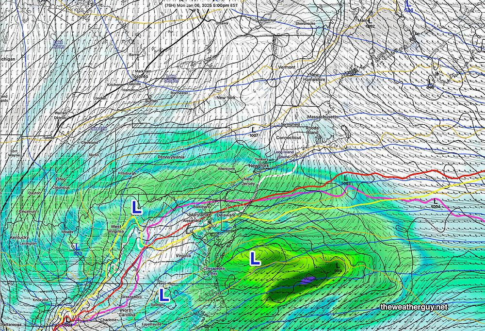
Posted Monday 01/06/25 @ 5:57 PM — “Hey. it’s snowing out”, said my wife a few minutes ago. I said, “that was supposed to move well to our south.” Yes, it’s snowing out and I can’t find a model that predicted this today. Current MRMS radar—
Tuesday Through Friday
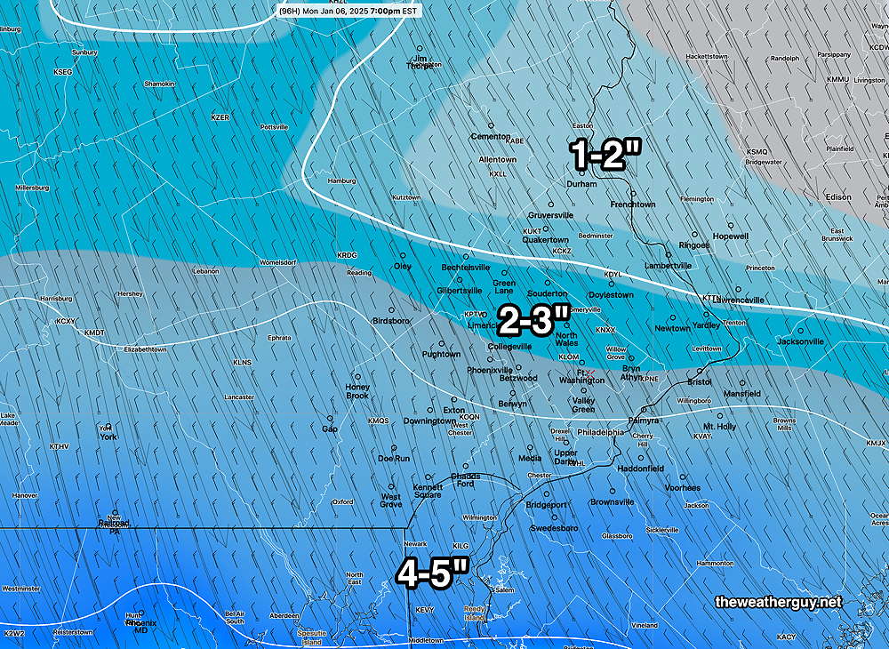
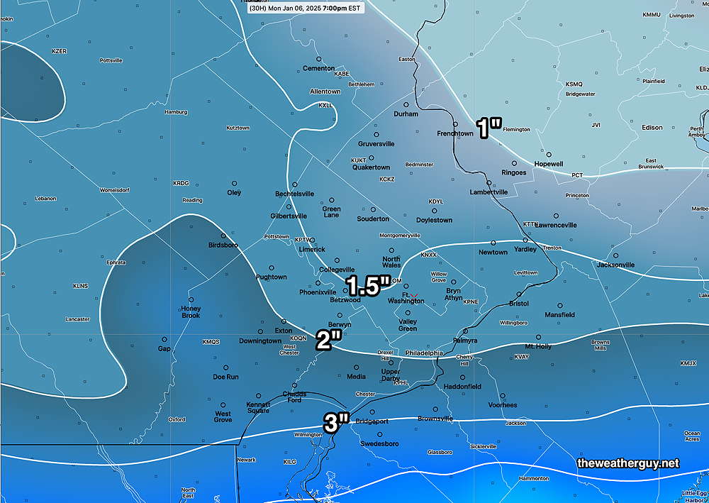
Posted Monday 01/06/25 @ 5:14 PM —A second low pressure system will bring some snow again this evening to far southern areas and will move out before daybreak Tuesday. This week from Tuesday through Friday will be partly to mostly sunny and quite cold as high pressure builds in from Canada.
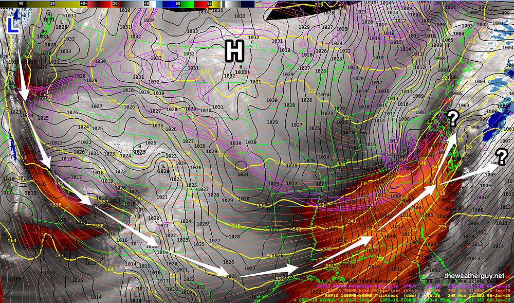
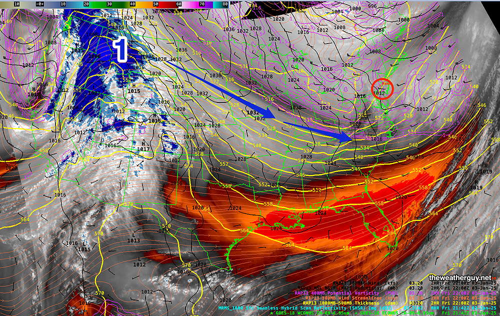
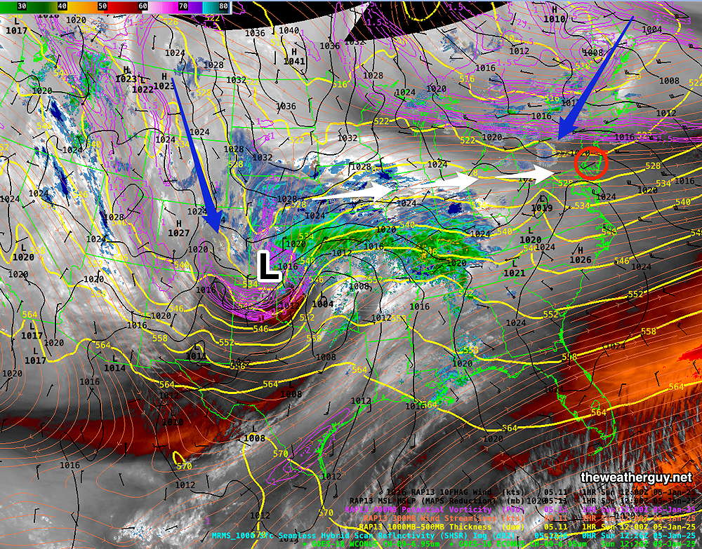
Another disturbance in the Pacific Northwest today (see above WV image) will move down to the Gulf of Mexico, then either out to sea or up the coast by Saturday.
There is the potential for a [snow] storm here Saturday according to the latest GFS, GEFS, NAEFS and Canadian Global, or just some light snow according to the latest ECMWF. Too soon to call. Stay tuned.
Due to its highly unbalanced political environment, I’ve considerably cut back auto-posting there. To receive all of my forecast updates, I recommend following me on mastodon.social or bluesky.social.
Previous postings about this snowfall from the past several days can found here.
Monday Snow Update
Posted Monday 01/06/25 @ 10:21 AM — While the NBM model updates hourly, its 01z 07z 13z 19z model runs include newly precip precip data. The previous posting was the 12z NBM.
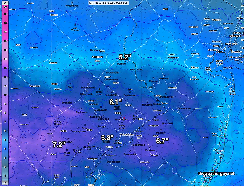
Here’s the 13z NBM (8AM) with refreshed precip data. Additional snow totals from 10AM forward—
Posted Monday 01/06/25 @ 9:31 AM — The snow began as forecast and should continue light through noon, then become spotty in the afternoon and taper off.
Here’s the additional snow accumulation from 7 AM onward, based on the NBM. (Add to what already fell in your location at 7 AM.)
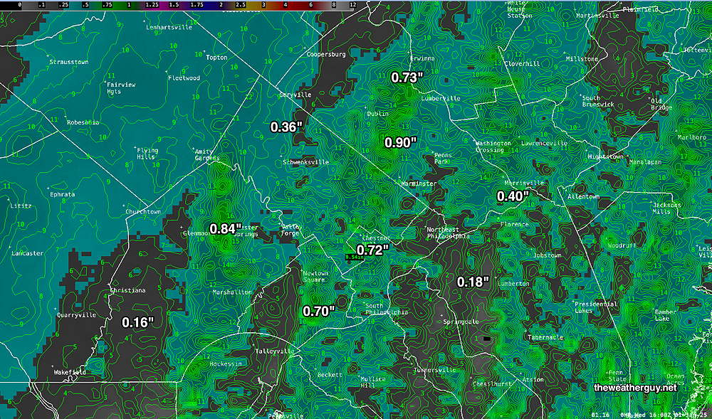
Final Snow Accumulation Call
Posted Sunday 01/05/25 @ 5:34 PM — There’s a solution to the snow forecast dilemma. The Model Blend (NBM) initializes with the HRRR, combines many models (last count 43) and statistically weights each based on how well each did forecasting the previous 6 hour period. It also weights each model based on their overall track record. Quite a process.
Here’s the latest NBM with a precipitation update—
The above is in line with the latest GFS and is where I would hang my hat on tomorrow.
Snow Lovers to be Disappointed Monday?
Posted Sunday 01/05/25 @ 4:07 PM — It’s not very often that I can correct a subject heading simply by adding a question mark! At this website, you actually get to see the (forecast) sausage being made.
First, snow moves in from the southwest between 3 AM and 6 AM and tapers off to snow showers during Monday evening.
The afternoon models have trended back towards slightly higher snow totals in the Philadelphia region. Here’s the latest NAM, my preferred model for snow when there is blocking high pressure to the north—
The HRRR, a much more advanced model than the NAM, has been the most consistent over the past two days with consistently higher forecast snow accumulations. As you’ll see, there’s quite a difference in forecast amounts—
The ECMWF also shows snow, but there’s an 8 hour delay in release of their free data, so this model run is from 7AM (12z) this morning—
I don’t think any single model is going nail it down but an average of the NAM and HRRR looks about right.
Posted Sunday 01/05/25 @ 12:21 PM — After reviewing the new GFS, RGEM and HRDPS, the threat of a moderate snowfall on Monday is no longer on the table. I’ll post new graphics later, but about 1 to 1.5” near the city, less north, and about 2 possibly 3 inches southern Delaware and Chester counties.
Posted Sunday 01/05/25 @ 9:48 AM — As has been the forecast trend over the past day, high pressure nosing down from the northeast will greatly limit moisture from moving into our area. Several global models first caught this trend but some of NOAA models were slow to pick up on it.
The models are all moving in the same direction now. Here’s the latest NAM snow forecast—
The NAM-NEST has even less—
The 13z NBM is so low that I want to check my calculation graphics before posting it.
Blocking High Pressure to Limit Snowfall in Philadelphia
Posted Sunday 01/05/25 @ 7:40 AM — As mentioned over the past day, most models, especially the ECMWF, Canadian RGEM and German ICON, along with the ECMWF- AIFS model and several ensemble models have forecast blocking high pressure to nose down into the Philadelphia area from the northeast and block moisture from moving aloft over us. Less snow than previously forecast is the result.
The NAM, NAM-NEST, NBM and last night’s HRRR were still predicting moderate snowfall for us.
Here’s the current setup—
Snow lovers will be disappointed with the current trend, but here’s the Canadian RGEM which has consistently downplayed snow accumulation here and is representative of many model trends—
The next major model run at 7 AM (12z) is being processed by the supercomputers as I write this. The NAM NAM-NEST and HRRR will be available soon, as will the 01z NBM with updated precip data.
I’ll update by 10 AM today.
Previously Posted Saturday 01/04/25 @ 10:05 PM — A quick update with tonight’s latest 00z models, the NAM and the HRRR. The NAM continues in the general moderate range as seen earlier—
The HRRR is an eye-opener and possibly a single model run error—
Updates Sunday morning after 9:45 AM with the newer 12z models.
Previously Posted Saturday 01/04/25 @ 5:05 PM — I’m glad I gave this the title of “Potential Winter Storm”, since more and more models are forecasting high pressure to nose down from the northeast, blocking any significant snowfall in our area and to our northeast.
The European (ECMWF), Canadian RGEM and German ICON models are now forecasting a minimal snowfall for Philadelphia on Monday. However our US -NOAA models continue to forecast a moderate snowfall.
Perhaps the most striking in the low range is the RGEM, which just became available and shows little to no snow!—
The latest ECMWF that’s available is from this morning. It also trends towards low snow totals—
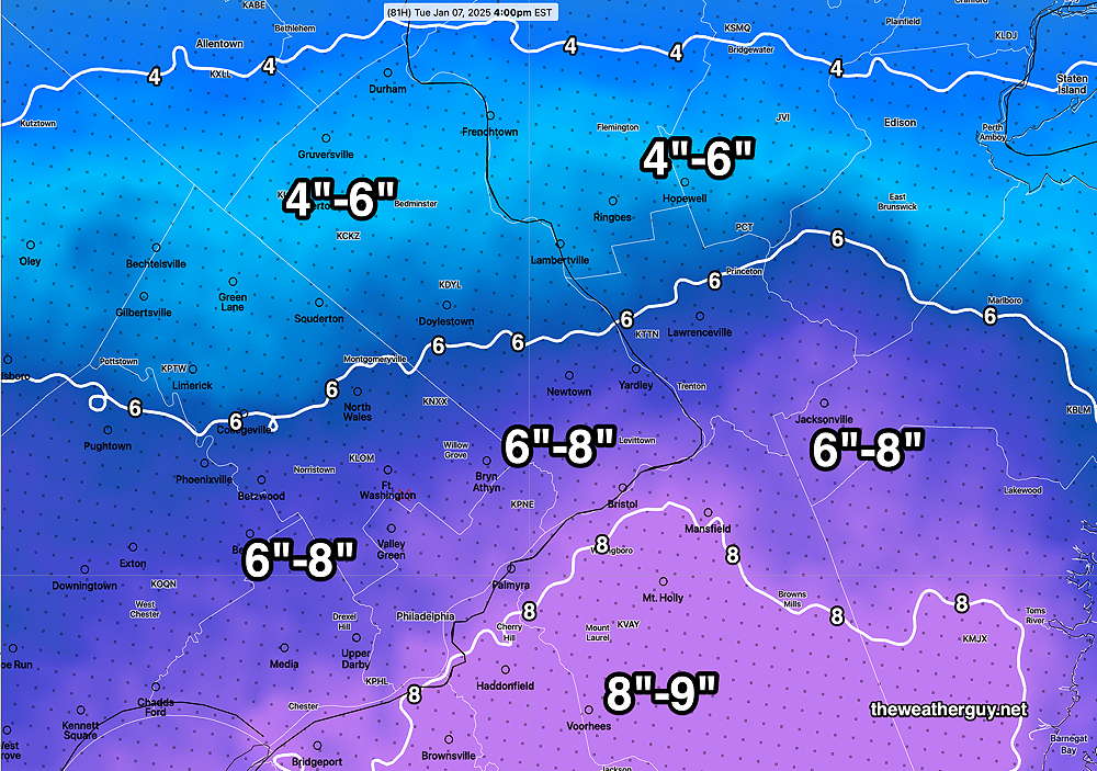
The GFS is still predicting a moderate snowfall—
Long time readers of this blog know my mantra, “Never ignore the NAM”.
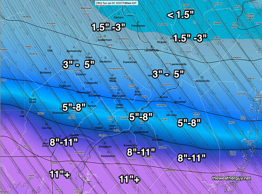
The NAM is also still predicting a moderate snowfall here—
As they say about elections, it’s too soon to call. But there’s a wide range of forecasts.
The NAM does tend to run high about 48 hours out, so I’m inclined to hang my hat on tomorrow’s NAM runs. In its favor, it generally captures any southward suppression of snowfall.
You would think the AI models would be useful. The ECMWF-AI model is leaning towards the low end, with a range of 1.5″- 3″ for most of the Philadelphia area.
So I’m still leaning towards the moderate snowfall of the GFS and NAM, but with knowledge that this might be incorrect.
Previously Posted Saturday 01/04/25 @ 11:51 AM — This morning’s (06z) ECMWF continues to show much less of a snow shield north of this system. Here’s its snow forecast—
Previously Posted Saturday 01/04/25 @ 9:16 AM — There are differences between the European Model (ECMWF) and the NOAA models, with the NOAA models forecasting a more northern shield of precipitation (snow) than the ECMWF. The ECMWF forecast has the low pressure system to our south—
I’m inclined to stay with our NOAA models.
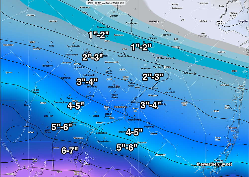
Reviewing the latest NAM and NBM, here’s the latest snow accumulation forecast—
Here’s the latest NBM forecast—
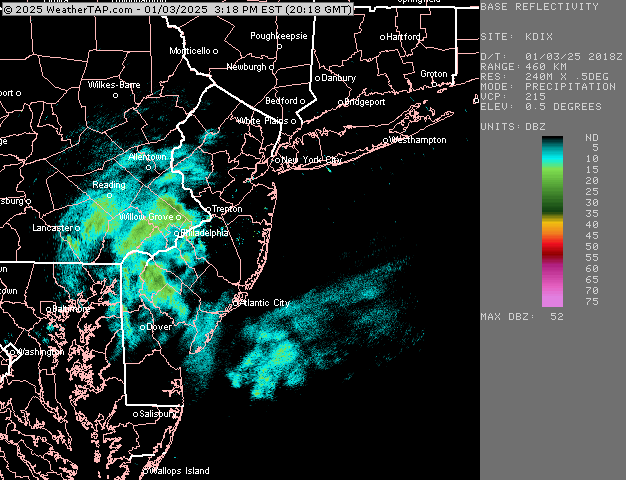
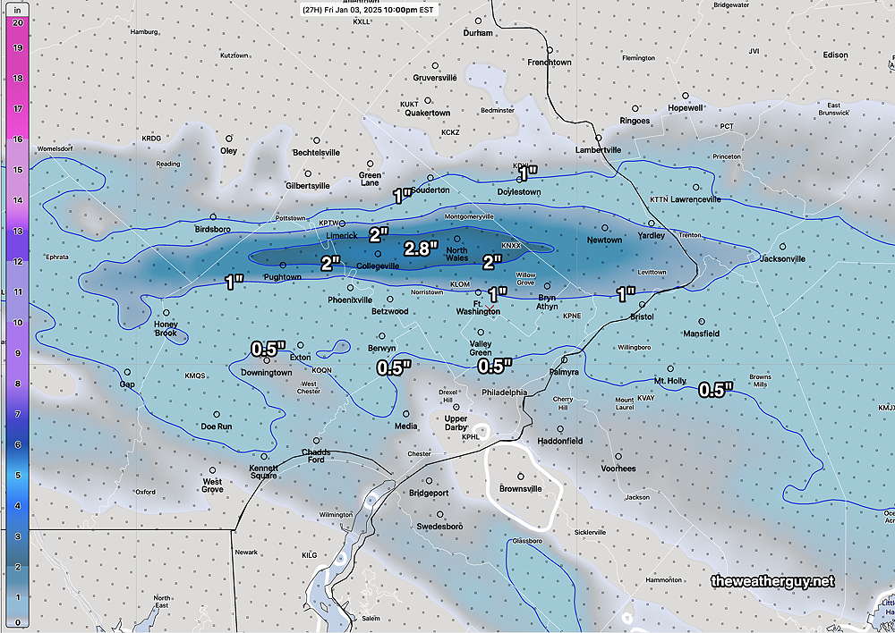
Previously Posted Friday 01/03/25 @ 9:56 PM A quick update. After looking over the afternoon models, and tonight’s NAM, the trend has been for a southern track for the heaviest snow. The global ensemble (statistical) models are remarkably similar with similar areas of uncertainty in position and speed of the system.
I’m posting the latest snow forecast, based on the latest NAM model which just became available—
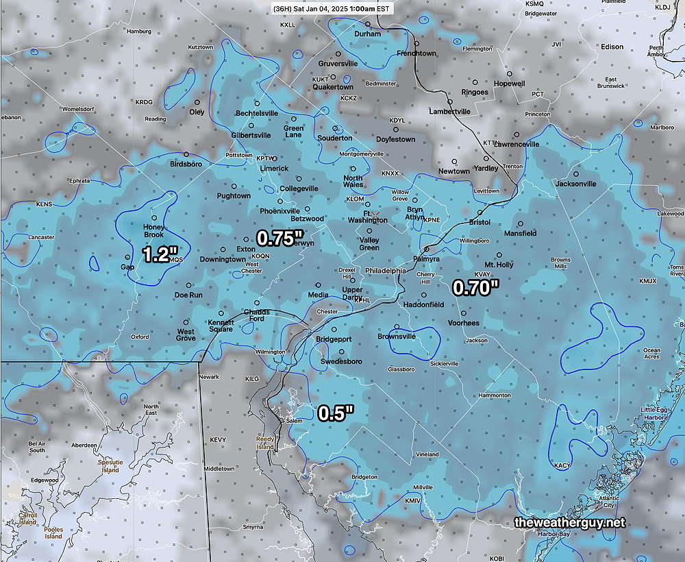
Previously Posted Friday 01/03/25 @5:51 PM —There remains uncertainty with the final track of the storm and the degree of intensification. The general trend has been for a track that’s further south, giving the Philadelphia region less snowfall than had been predicted yesterday.
Here’s the current GFS forecast, showing several low pressure centers.
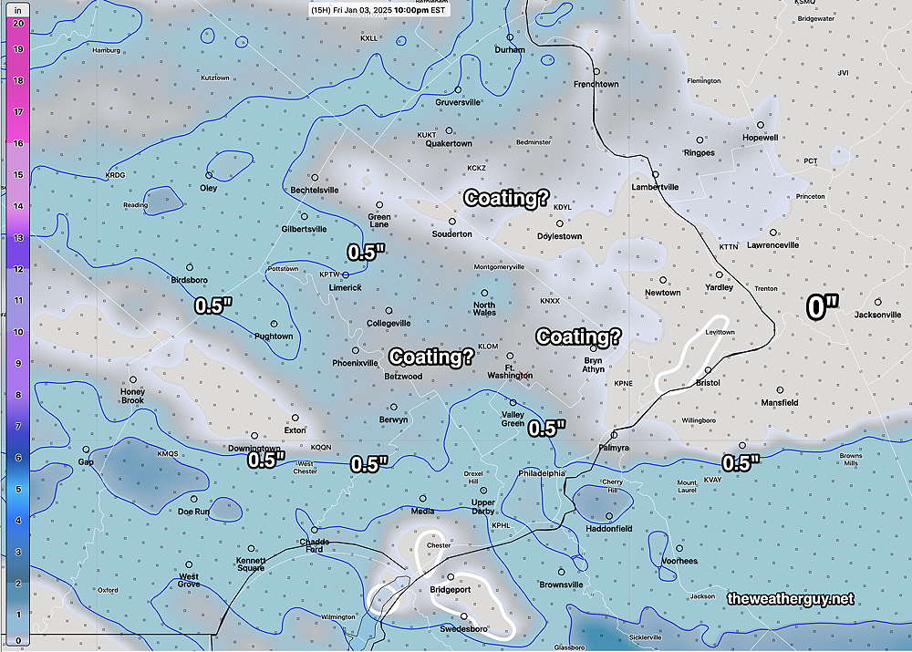
Here’s what I’m calling for, based on the latest NBM precipitation forecast—