SUNDAY FORECAST UPDATE

Updated Sun 7:25 AM highlighted below:

This update is really a cut and paste from my original forecast from Friday.

A weak warm front will move in before daybreak on Sunday. Some scattered showers before daybreak. Clouds early will break for sunshine by afternoon. 

As a result of this warm front, Sunday will have noticeably higher humidity (dew points) than Saturday. Dew points will move back into the uncomfortable 70º range.

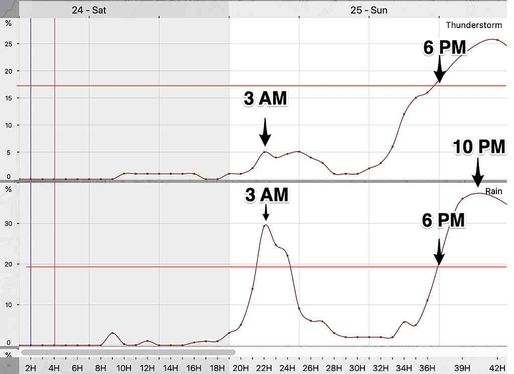
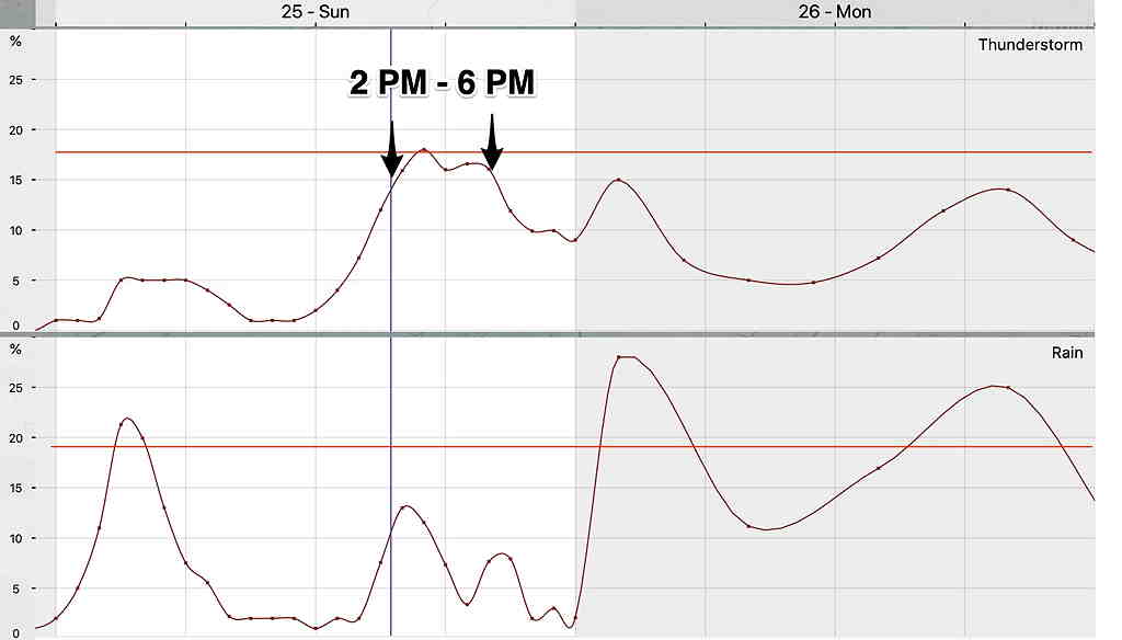
Today’s models have the weak front moving through earlier on Sunday afternoon than previously forecast. Latest models have scattered showers and thunderstorms developing in western suburbs as early as 2 PM. High temp tomorrow 89.4º 88.3º± 1.2º Dew points uncomfortable, near 70º

Most models have the activity diminishing as it moves into NJ.

More rain later Sunday night, after midnight.

Meteogram timing still on-track

NBM precip forecast for Sunday, Blue Bell, PA (The peak probability is 2-6 PM and is not that impressive. ) Click on image for a larger view.
Canadian GEM regional model forecast 2 PM Sunday (Click on image for a larger view.)

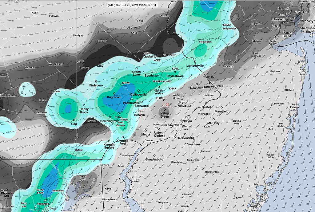
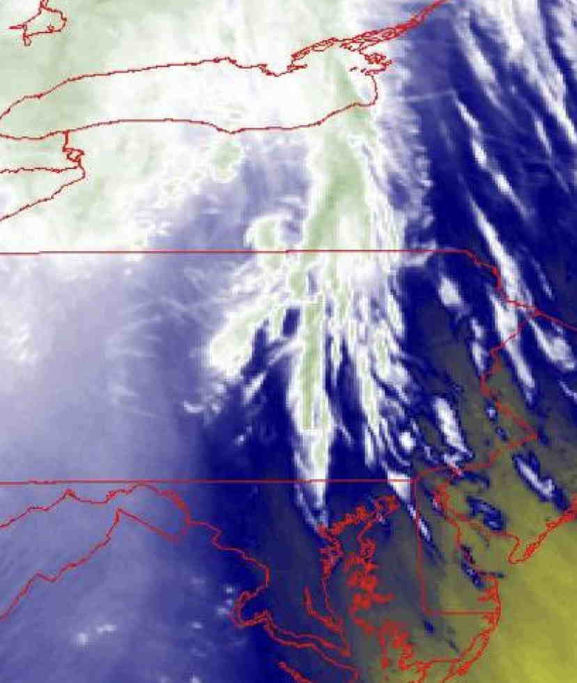
Water Vapor Imagery and Advancing Warm front

I love looking at the clouds and seeing what they tell about the model weather forecasts. Today’s approaching warm front is visible on water vapor imagery. Latest water vapor imagery is can be seen at this link.

Unlike visible satellite imagery, the colors of water vapor imagery indicates the water vapor temperature and height. Here we see upper air disturbances spilling out ahead of the warm front just west of central PA about 2 PM Saturday.
The advancing upper air disturbances visible on water vapor to the north and west caused the development of some mixed clouds and cumulus clouds with vertical growth on the Pennsylvania side of the Delaware River at about 3 PM Saturday.

WEEKEND WEATHER FORECAST

Updated on Sat 9:12 AM highlighted below


The cooler, less humid air mass that moved in will continue to influence our weather on Saturday. Two weak fronts will move in Sunday.

Saturday will be partly sunny. Return of moisture aloft may result in some cloudiness in the afternoon with a slight chance of an isolated shower far ahead of an approaching warm front. High temperature 86.0º ± 1.3º NBM model Blue Bell. Dew points in the upper 50s to near 60º.

UPDATED NBM thunderstorm/rain probabilities timing meteogram for Blue Bell, PA; MOST OF THE ACTIVITY IS STILL FORECAST TO REMAIN JUST TO THE WEST OF PHILADELPHIA SUNDAY EVENING. (Click on image for a larger view.)
Latest NBM precip forecast 8 PM Sunday. (Click on image for a larger view.)

A weak warm front will move in before daybreak on Sunday. Some scattered showers before daybreak. Clouds early will break for sunshine by afternoon.

As a result of this warm front, Sunday will have noticeably higher humidity (dew points) than Saturday. Dew points will move back into the uncomfortable 70º range. High temperature 87.0º ± 2.2º NBM model Blue Bell.

A weak surface trough may move through on Sunday evening with scattered showers and maybe some thunderstorms especially in western suburbs.


Outlook

While we’ll be moving back into the 90º+ range by Tuesday, the extreme heat being forecast for the middle of the country does not appear to make it into our area because we’ll still be a slightly different upper air situation—

Jet stream level flow on Friday. Extreme heat is kept from our immediate area. (Click on image for a larger view.)

Weather… and Other Things 'Up in the Air'