Following a milder Thursday, a cold front will move through Thursday evening with showers. Friday will be colder again, but the frontal boundary will return as a warm front on Saturday with significant mid level cloudiness.
Clouds break for a time on Sunday before more clouds move in late afternoon ahead of a stronger cold front on Monday. A significant storm develops late Monday, but the main impact of this storm may miss us.
Update Sun 11:50 AM — Several models have a few hours of sunshine mid afternoon on Sunday.
Update Sat @ 5:53 PM — The cold front came through about 1:30 PM today, within the forecast range but a little later than Friday’s models had suggested.
As mentioned in the Sunday forecast, it still looks like Sunday will have considerable mid-level cloudiness develop during the morning with possible breaks of sunshine in the afternoon. The cloud cover will be mid-level clouds and suggest a winter-like day. A strong upper air disturbance will cause the cloudiness—
GFS Jet stream level forecast for 2 PM Sunday, Notice the jet streak just entering our area. The same active flow will bring another cold front through Monday. (Click on image for a larger view.)
Another front moves through Monday.
Update Fri 9:52 PM —Tonight’s models are coming in with lighter precipitation (< 0.10 “) on Saturday than the earlier GFS-based forecast. Timing 11:30 AM to 2 PM. WINDY. Remainder of forecast unchanged.
Initial Post Discussion—[post_published]
The GFS was ahead of the pack predicting the frontal passage today and the afternoon clearing. I’m going to lean towards the GFS for the weekend forecast. The weekend will will feature a cold front passage Saturday and much colder weather for Sunday.
GFS “simulated radar” forecast for 1 PM Saturday. (Click on image for a larger view.)
Saturday
A strong cold front will move through mid-day Saturday from about 11:30 AM through 1:30 PM. Temperatures fall rapidly after the frontal passage.
Clouds and winds will increase during the morning, and by about noon, showers will develop. The GFS and HIRESW-FV3, ICON and Canadian GEM models are predicting showers with the frontal passage.
However, the latest HRRR has the showers passing by to our north and some other models have negligible precipitation. I’m leaning towards the GFS which has 0.20 inches of rain falling.
Temperatures in the 50s in the morning will drop into the 40s by early afternoon and into the 30s by nightfall.
Sunday will be sunny in the early morning, but an upper air disturbance, moisture and instability will cause considerable cloudiness by late morning into the afternoon. Skies may break for sun at times in the afternoon. It will be cold. Breezy. Highs 48.1º ± 0.9º
Update Fri @ 7:18 AM — The models have trended towards the line of the heaviest rain shearing off north and west of the city. While we still will be getting some substantial rain, the remaining line of storms may weaken as it passes through Philadelphia about 9 AM.
Update Thu @ 5:03 PM — Based on Thursday afternoon’s models, it appears that the cold front will move through about 7 -9 AM Friday morning. There’s enough CAPE to produce some thunderstorms and enough precipitable water to produce some briefly heavy downpours. Wind gusts 30- 40 mph, according to the HRRR. Rain until about noon. Most of the models have clouds breaking for sun in the afternoon.
HRRR Simulated Radar forecast 8 AM Friday (Click on image for a larger view.)
A period of showers possible early afternoon Saturday with the second cold front, as described below.
Update Thu @ 10:26 AM — The forecast continues to clarify somewhat (based on the GFS), with rain from the first front moving through after midnight tonight (Thurs) and tapering and ending around noon on Friday. Gusty winds Friday morning. About 1 inch of rain possible, more to the north and west. Partial clearing possible Friday afternoon. The model blend (NBM) is moving closer to this GFS forecast of rain ending earlier on Friday.
The morning HIRESW models have joined the GFS with rain ending late morning Friday. Any showers mid-day Saturday and Saturday afternoon with the second front appear to be light.
The first front stalls to our south as low pressure develops along and moves up towards us on Saturday. The GFS has additional showers developing around noontime on Saturday as this stronger cold front moves through. Gusty winds about 30 mph. It should be noted that the NBM still keeps us dry on Saturday, indicating there is a lack of model consensus with the GFS’s forecast but the latest HIRESW-FV3 (closer to the GFS in data input and structure) has considerable rain for Saturday afternoon.
The model blend (NBM) tends to be a lagging forecast, by its very nature and design. When there are changes in the forecast, the NBM can be slow to reflect those changes.
Update Wed @ 8:28 PM — The GFS continues to forecast the rain ending late Friday morning with the passage of a cold front with partial clearing possible in the afternoon. The model blend (NBM) continues to prolong the rain through much of Friday afternoon. I’m leaning towards the GFS model at this time.
The GFS consistently shows the colder air hanging back on Friday and then moving through Saturday with a second cold front that is swept through by low pressure that develops along the first cold front. So Saturday look like it will have some rain for at least the first part of the day. The model blend (NBM) has us dry. Clearly, there are uncertainties with the forecast.
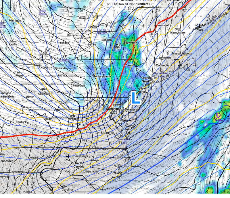
GFS forecast for Saturday 12 PM. Red line is “540” thickness line (1000-500 mb thickness) denoting the edge of an airmass that is cold enough to support snow. It’s a bit more complicated… Don’t expect any snow here. (Click on image for a larger view.)
Update Wed @ 7:56 AM — Forecast differences between the GFS (which has the rain ending Friday morning) and the NAM / SREF which has the rain remaining through much of Friday. The model blend (NBM) sides with the NAM and lingering rain.
Update Tue @ 8:55 PM — Temperatures today were higher than forecast. A weak front moves through before daybreak Wednesday so tomorrow’s high temps may be closer to the mid 60s.
The model trend is for Friday’s cold front to move through our area somewhat earlier than had been previously forecast. Showers may begin as early as the evening Thursday. It appears the front will move off the coast Friday morning, so Friday does not look as rainy as had been previously forecast.
This afternoon’s GFS shows that second low, mentioned in my post below, forming along the front bringing some rain Saturday morning, This will sweep a secondary cold front through Saturday. Not all models on-board with this GFS forecast.
Initial Post Discussion—[post_published]
The beautiful weather (although chilly) we’ve been having is expected to continue through much of Thursday. Moderating temperatures expected through the week with highs reaching the low 60s. Average highs are 55º (Blue Bell) and 57º (Philadelphia).
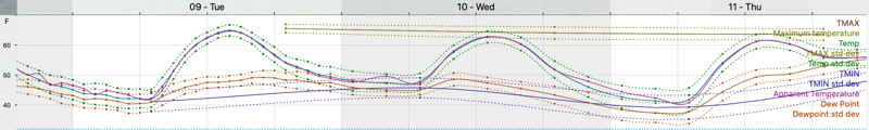
Model Blend (NBM) Temperature forecast Tues-Thurs. (Click on image for a larger view.)
Deep low pressure over the Great Lakes will pull a warm front, then a cold front through our area.
The warm front is forecast to move through after midnight Thursday with the cold front following during the morning on Friday. Windy conditions will accompany both fronts. About 1 inch of rain is forecast.
A second low may form along the front, prolonging the rain. Much colder weather is expected for the weekend and is forecast to last well into next week.
GFS forecast for Friday at 10 AM. Yes, that’s snow in the violet shading (Minnesota-Wisconsin) There’s some “bagginess” in the isobars over Maryland suggesting a secondary low pressure system may form prolonging the rain here on Friday.